Related Research Articles

The Greater London Council (GLC) was the top-tier local government administrative body for Greater London from 1965 to 1986. It replaced the earlier London County Council (LCC) which had covered a much smaller area. The GLC was dissolved in 1986 by the Local Government Act 1985 and its powers were devolved to the London boroughs and other entities. A new administrative body, known as the Greater London Authority (GLA), was established in 2000.

The London Borough of Southwark in South London forms part of Inner London and is connected by bridges across the River Thames to the City of London and London Borough of Tower Hamlets. It was created in 1965 when three smaller council areas amalgamated under the London Government Act 1963. All districts of the area are within the London postal district. It is governed by Southwark London Borough Council.

Kidbrooke is an area of South East London, England, in the Royal Borough of Greenwich 7+1⁄2 miles (12 km) south-east of Charing Cross and north west of Eltham.

Poplar is a district in East London, England, now part of the London Borough of Tower Hamlets. Five miles (8 km) east of Charing Cross, it is part of the East End.
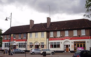
Elm Park is a suburban planned community in East London and part of the London Borough of Havering. Located 14.3 miles (23.0 km) east-northeast of Charing Cross, it is identified as a district centre in the London Plan with several streets of shops and a priority for regeneration. Prior to the construction of the extensive Elm Park Garden City development in the 1930s it was a scattered settlement of farms in the south of the parish of Hornchurch. Elm Park has been connected to central London by the electrified District line service since 1935 and the planned development of the area formed part of the interwar private housing boom that was interrupted by World War II. After the war Elm Park expanded with social housing and it has formed part of Greater London since 1965.

The districts of England are a level of subnational division of England used for the purposes of local government. As the structure of local government in England is not uniform, there are currently four principal types of district-level subdivision. There are a total of 294 districts made up of 36 metropolitan boroughs, 32 London boroughs, 164 two-tier non-metropolitan districts and 62 unitary authorities, as well as the City of London and Isles of Scilly which are also districts, but do not correspond to any of these categories. Some districts are styled as cities, boroughs or royal boroughs; these are purely honorific titles and do not alter the status of the district or the powers of their councils. All boroughs and cities are led by a mayor who in most cases is a ceremonial figure elected by the district council, but—after local government reform—is occasionally a directly elected mayor who makes most of the policy decisions instead of the council.

The London County Council (LCC) was the principal local government body for the County of London throughout its existence from 1889 to 1965, and the first London-wide general municipal authority to be directly elected. It covered the area today known as Inner London and was replaced by the Greater London Council. The LCC was the largest, most significant and most ambitious English municipal authority of its day.

The County of London was a county of England from 1889 to 1965, corresponding to the area known today as Inner London. It was created as part of the general introduction of elected county government in England, by way of the Local Government Act 1888. The Act created an administrative County of London, which included within its territory the City of London. However, the City of London and the County of London formed separate ceremonial counties for "non-administrative" purposes. The local authority for the county was the London County Council (LCC), which initially performed only a limited range of functions, but gained further powers during its 76-year existence. The LCC provided very few services within the City of London, where the ancient Corporation monopolised local governance. In 1900, the lower-tier civil parishes and district boards were replaced with 28 new metropolitan boroughs. The territory of the county was 74,903 acres (303.12 km2) in 1961. During its existence, there was a long-term decline in population as more residents moved into the outer suburbs; there were periodic reviews of the local government structures in the greater London area and several failed attempts to expand the boundaries of the county. In 1965, the London Government Act 1963 replaced the county with the much larger Greater London administrative area.

Bexley is an area of south-eastern Greater London, England and part of the London Borough of Bexley. It is sometimes known as Bexley Village or Old Bexley to differentiate the area from the wider borough. It is located 13 miles (21 km) east-southeast of Charing Cross and south of Bexleyheath.

Burgess Park is a public park situated in Camberwell the London Borough of Southwark, and is close to Walworth to the north, Bermondsey to the east and Peckham to the south. At 56 hectares, it is one of the largest parks in South London.
The new towns in the United Kingdom were planned under the powers of the New Towns Act 1946 and later acts to relocate populations in poor or bombed-out housing following the Second World War. They were developed in three waves. Later developments included the expanded towns: existing towns which were substantially expanded to accommodate what was called the "overspill" population from densely populated areas of deprivation.

Healthy Village or Healthy Village Estate is a public housing and Flat-for-Sale Scheme estate in Tsat Tsz Mui, near the western end of Quarry Bay, Hong Kong Island, Hong Kong, developed by the Hong Kong Housing Society. It is divided into 3 phases and located at Tsat Tsz Mui Road, King's Road and Pak Fuk Road respectively. It consists of 14 residential blocks completed between 1965 and 1997.
Wandsworth London Borough Council is the local authority for the London Borough of Wandsworth in Greater London, England. It is a London borough council, one of 32 in the United Kingdom capital of London. Wandsworth is divided into 20 wards, each electing three councillors. After the May 2022 election, 35 of these councillors were Labour and 22 were Conservatives, with 1 independent. The Conservatives had an overall majority on the council since 1978, until Labour won control in the 2022 election.

Brent London Borough Council is the local authority for the London Borough of Brent in Greater London, England. It is a London borough council, one of 32 in the United Kingdom capital of London. It is based at Brent Civic Centre in Engineers Way, Wembley.

Bromley London Borough Council is the local authority for the London Borough of Bromley in Greater London, England. It is one of 32 London borough councils.

Enfield London Borough Council is the local authority for the London Borough of Enfield in Greater London, England. It is one of 32 London borough councils in the United Kingdom capital of London.
Hammersmith and Fulham London Borough Council is the local authority for the London Borough of Hammersmith and Fulham in Greater London, England. It is a London borough council, one of 32 in the United Kingdom capital of London. Hammersmith and Fulham is divided into 21 wards, electing a total of 50 councillors. The council was created by the London Government Act 1963 as the Hammersmith London Borough Council and replaced two local authorities: Hammersmith Metropolitan Borough Council and Fulham Metropolitan Borough Council. The council was renamed on 1 January 1980.

Draped Seated Woman 1957–58 is a bronze sculpture by the British artist Henry Moore, cast in an edition of seven in the 1950s. The sculpture depicts a female figure resting in a seated position, with her legs folded back to her right, her left hand supporting her weight, and her right hand on her right leg. The drapery emphasises the female figure, but the facial features are abstracted and barely picked out.
Myatt's Fields South is a social housing estate located between Brixton Road and Camberwell New Road in South London. It is on land that once formed part of the Lambeth Wick estate.