Westminster

Last updated

Westminster
Westminster, 2023.jpg
Westminster Abbey St Peter.jpg
Western facade of Westminster Abbey
Greater London UK location map 2.svg
Red pog.svg
Westminster
Location within Greater London
OS grid reference TQ295795
  Charing Cross 0.58 mi (0.9 km)  NEbE
London borough
Ceremonial county Greater London
Region
Country England
Sovereign state United Kingdom
Post town LONDON
Postcode district SW1
Dialling code 020
Police Metropolitan
Fire London
Ambulance London
UK Parliament
London Assembly
List of places
UK
England
London
51°29′41″N00°08′07″W / 51.49472°N 0.13528°W / 51.49472; -0.13528

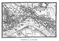
Westminster is the main settlement of the City of Westminster in London, England. It extends from the River Thames [1] to Oxford Street and has many famous landmarks, including the Palace of Westminster, Buckingham Palace, Westminster Abbey, Westminster Cathedral, Trafalgar Square and much of the West End cultural centre including the entertainment precinct of West End Theatre.

Contents

The name (Old English : Westmynstre) [2] originated from the informal description of the abbey church and royal peculiar of St Peter's (Westminster Abbey), west of the City of London (until the English Reformation there was also an Eastminster, near the Tower of London, in the East End of London). The abbey's origins date from between the 7th and 10th centuries, but it rose to national prominence when rebuilt by Edward the Confessor in the 11th century. Westminster has been the home of England's government since about 1200, and from 1707 the Government of the United Kingdom. In 1539, it became a city.

Westminster is often used as a metonym to refer to the Parliament of the United Kingdom, which sits in the Palace of Westminster.

Geography

Physical geography

The City and Liberty of Westminster and other historical Westminster administrative units (except the broader modern City of Westminster, a London Borough created in 1965) extended from the River Thames to the old Roman road from the City to western England, which is now locally called Oxford Street.

LondonBeforeHouses.jpg

{{{annotations}}}

LondonBeforeHouses.jpg
Westminster before urbanisation. The Roman road (modern Oxford Street) is shown to the north.

Thorney Island lay between the arms of the former River Tyburn at its confluence with the Thames, while the western boundary with Chelsea was formed by the similarly lost River Westbourne. [3] The line of the river still forms (with very slight revisions) the boundaries of the modern borough with the Royal Borough of Kensington and Chelsea.

Parishes and Places of the City and Liberty of Westminster. The lower Westbourne formed part of the western boundary, and Oxford Street the north. Westminster Civil Parish Map 1870.png
Parishes and Places of the City and Liberty of Westminster. The lower Westbourne formed part of the western boundary, and Oxford Street the north.

Further north, away from the river mouth, Westminster included land on both sides of the Westbourne, notably Knightsbridge (including the parts of Hyde Park west of the Serpentine lake (originally formed by damming the river) and most of Kensington Gardens).

Localities

Westminster includes the sub-districts of Soho, St James, Mayfair, Covent Garden, Pimlico, Victoria, Belgravia and Knightsbridge (shared with neighbouring Kensington).

The former City of Westminster merged with the neighbouring boroughs of Paddington and Marylebone in 1965 to form a larger modern borough. These neighbouring areas (except for a small area of Paddington in part of Kensington Gardens), lie north of Oxford Street and its westward continuation, Bayswater Road.

Open spaces

The district's open spaces include:

Origins and administration

The development of the area began with the establishment of Westminster Abbey on a site then called Thorney Island. The site may have been chosen because of the natural ford which is thought to have carried Watling Street over the Thames in the vicinity. [4] The wider district became known as Westminster in reference to the church.

Legendary origin

The legendary origin [5] is that in the early 7th century, a local fisherman named Edric (or Aldrich) ferried a stranger in tattered foreign clothing over the Thames to Thorney Island. It was a miraculous appearance of St Peter, a fisherman himself, coming to the island to consecrate the newly-built church, which later developed into Westminster Abbey. He rewarded Edric with a bountiful catch when he next dropped his nets. Edric was instructed to present the king and St. Mellitus, Bishop of London, with a salmon and various proofs that the consecration had already occurred. Every year on 29 June, St Peter's Day, the Worshipful Company of Fishmongers presents the Abbey with a salmon in memory of this event. [6]

Recorded origin

A charter of 785, possibly a forgery, grants land to the needy people of God in Thorney, in the dreadful spot which is called Westminster. The text suggests a pre-existing monastic community who chose to live in a very challenging location.

The recorded origins of the Abbey (rather than a less important religious site) date to the 960s or early 970s, when Saint Dunstan and King Edgar installed a community of Benedictine monks on the site. [7]

Between 1042 and 1052, King Edward the Confessor began rebuilding St Peter's Abbey to provide himself with a royal burial church. It was the first church in England built in the Romanesque style. The building was completed around 1060 and was consecrated on 28 December 1065, only a week before Edward's death on 5 January 1066. [8] A week later, he was buried in the church; and, nine years later, his wife Edith was buried alongside him. [9] His successor, Harold II, was probably crowned in the abbey, although the first documented coronation is that of William the Conqueror later the same year. [10]

St Peter's Abbey at the time of Edward's funeral, depicted in the Bayeux Tapestry BayeuxTapestryScene26.jpg
St Peter's Abbey at the time of Edward's funeral, depicted in the Bayeux Tapestry

The only extant depiction of Edward's abbey, together with the adjacent Palace of Westminster, is in the Bayeux Tapestry. Some of the lower parts of the monastic dormitory, an extension of the south transept, survive in the Norman Undercroft of the Great School, including a door said to come from the previous Saxon abbey. Increased endowments supported a community that increased from a dozen monks in Dunstan's original foundation, up to a maximum of about eighty monks. [11]

Local government

The Metropolitan Borough of Westminster was almost co-terminous with the older City and Liberty of Westminster, with ancient Oxford Street as the northern boundary. Westminster Met. B Ward Map 1916.svg
The Metropolitan Borough of Westminster was almost co-terminous with the older City and Liberty of Westminster, with ancient Oxford Street as the northern boundary.

Parish of Westminster St Margaret

John Norden's Map of Westminster (1593) John Norden's Map of Westminster Large version.jpeg
John Norden's Map of Westminster (1593)

Most of the parishes of Westminster originated as daughter parishes of St Margaret's parish, in the City and Liberty of Westminster, Middlesex. The exceptions to this were St Clement Danes, St Mary le Strand and possibly some other small areas.

The ancient parish was St Margaret; after 1727 this became the civil parish of 'St Margaret and St John', the latter a new church required for the increasing population. The area around Westminster Abbey formed the extra-parochial Close of the Collegiate Church of St Peter. Like many large parishes, Westminster was divided into smaller units called Hamlets (meaning a territorial sub-division, rather than a small village). These would later become independent daughter parishes.

Until 1900 the local authority was the combined vestry of St Margaret and St John (also known as the Westminster District Board of Works from 1855 to 1887), which was based at Westminster Town Hall in Caxton Street from 1883. [12]

City and Liberty of Westminster

The Liberty of Westminster, governed by the Westminster Court of Burgesses, also included St Martin in the Fields and several other parishes and places. Westminster had its own quarter sessions, but the Middlesex sessions also had jurisdiction.

Metropolitan Borough of Westminster

Westminster City Hall, completed in 1965 Westminster City Hall, Victoria Street SW1 - geograph.org.uk - 1284668.jpg
Westminster City Hall, completed in 1965

Under local government reforms in 1889, the area fell within the newly created County of London, and the local government of Westminster was further reformed in 1900, when the court of burgesses and the parish vestries were abolished and replaced by the Metropolitan Borough of Westminster. The borough was given city status at the same time, allowing it to be known as the City of Westminster and its council as Westminster City Council.

The City and Liberty of Westminster and the Metropolitan Borough of Westminster were very similar in extent, covering the parts of the wider modern City of Westminster south of the Oxford Street, and its continuations Hyde Park Place. The exception is that part of Kensington Gardens, south of that road, are part of Paddington.

Westminster merged with St Marylebone and Paddington in 1965, but the combined area was allowed to keep the title City of Westminster. [13]

History

For a list of street name etymologies for Westminster see Street names of Westminster

Royal seat

Bird's-eye view of Westminster in 1909 Bird Eye Pictures of London Westminster in 1909.jpg
Bird's-eye view of Westminster in 1909

The former Thorney Island, the site of Westminster Abbey, formed the historic core of Westminster. The abbey became the traditional venue of the coronations of the kings and queens of England from that of Harold Godwinson (1066) onwards.

From about 1200 the Palace of Westminster, near the abbey, became the principal royal residence, a transition marked by the transfer of royal treasury and financial records to Westminster from Winchester. Later the palace housed the developing Parliament and England's law courts. Thus, London developed two focal points: the City of London (financial/economic) and Westminster (political and cultural).

The monarchs moved their principal residence to the Palace of Whitehall (1530–1698), then to St James's Palace in 1698, and eventually to Buckingham Palace and other palaces after 1762. The main law courts moved to the Royal Courts of Justice in the late-19th century.

Medieval and Tudor

The settlement grew up around the palace and abbey, as a service area for them. The parish church, St Margaret's Westminster served the wider community of the parish; the servants of the palace and abbey as well as the rural population and those associated with the high status homes developing on the road from the City. The area became larger and in the Georgian period became connected through urban ribbon development with the City along the Strand.

Henry VIII's Reformation in the early 16th century abolished the abbey and established a cathedral – thus the parish ranked as a "City", although it was only a fraction of the size of the City of London and the Borough of Southwark at that time.

Indeed, the cathedral and diocesan status of the church lasted only from 1539 to 1556, but the "city" status remained for a mere parish within Middlesex. As such it is first known to have had two Members of Parliament in 1545 as a new Parliamentary Borough, centuries after the City of London and Southwark were enfranchised. [14]

Emanuel Hospital, Westminster, 1890 by Philip Norman Emanuel Hospital, Westminster, 1890 by Philip Norman.jpg
Emanuel Hospital, Westminster, 1890 by Philip Norman

The growing Elizabethan city had a High Constable, Bailiff, Town Clerk, and a keeper of the ponds. [15]

Victorian divide

Part of Charles Booth's poverty map showing Westminster in 1889. The colours of the streets represent the economic class of the residents: Yellow ("Upper-middle and Upper classes, Wealthy"), red ("Lower middle class - Well-to-do middle class"), pink ("Fairly comfortable good ordinary earnings"), blue ("Intermittent or casual earnings"), and black ("lowest class occasional labourers, street sellers, loafers, criminals and semi-criminals"). Booth coloured Victoria Street, with its new shops and flats, yellow. The model dwellings built by the Peabody Trust on the side streets off Victoria Street appear as pink and grey, signalling modest respectability, while the black and blue streets represent the remaining slum areas housing the poorest. Booth map of Westminster.jpg
Part of Charles Booth's poverty map showing Westminster in 1889. The colours of the streets represent the economic class of the residents: Yellow ("Upper-middle and Upper classes, Wealthy"), red ("Lower middle class – Well-to-do middle class"), pink ("Fairly comfortable good ordinary earnings"), blue ("Intermittent or casual earnings"), and black ("lowest class occasional labourers, street sellers, loafers, criminals and semi-criminals"). Booth coloured Victoria Street, with its new shops and flats, yellow. The model dwellings built by the Peabody Trust on the side streets off Victoria Street appear as pink and grey, signalling modest respectability, while the black and blue streets represent the remaining slum areas housing the poorest.

Charles Booth's poverty map showing Westminster in 1889 recorded the full range of income- and capital-brackets living in adjacent streets within the area; its central western area had become (by 1850) (the) Devil's Acre in the southern flood-channel ravine of the River Tyburn, yet Victoria Street and other small streets and squares had the highest colouring of social class in London: yellow/gold. Westminster has shed the abject poverty with the clearance of this slum and with drainage improvement, but there is a typical Central London property distinction within the area which is very acute, epitomised by grandiose 21st-century developments, architectural high-point listed buildings [17] and nearby social housing (mostly non-council housing) buildings of the Peabody Trust founded by philanthropist George Peabody.

Wider uses of the name

Given the focus on Westminster in English and British public life over centuries, the name "Westminster" is casually used as a metonym for the UK Parliament and for the political community of the United Kingdom generally. (The civil service is similarly referred to using the name of the northern sub-neighbourhood which it inhabits, "Whitehall".) "Westminster" is consequently also used in reference to the Westminster system, the parliamentary model of democratic government that has evolved in the United Kingdom and for those other nations, particularly in the Commonwealth of Nations and for other parts of the former British Empire that adopted it.

The term "Westminster Village", sometimes used in the context of British politics, does not refer to a geographical area at all; employed especially in the phrase "Westminster Village gossip", it denotes a supposedly close social circle of members of parliament, political journalists, so-called spin-doctors and others connected to events in the Palace of Westminster and in Government ministries.

Westminster from the dome on Methodist Central Hall.jpg
Panorama of Westminster taken from the roof of the Methodist Central Hall

Economy

The area has a substantial residential population. By the 20th century Westminster saw rising numbers of residential apartments with wealthy inhabitants. Hotels, large Victorian homes and barracks exist near to Buckingham Palace.

High Commissions

Westminster hosts the High Commissions of many Commonwealth countries: [18]

Education

Within the area is Westminster School, a major public school which grew out of the abbey, and the University of Westminster, attended by over 20,000 students.

Notable people

Related Research Articles

<span class="mw-page-title-main">City of Westminster</span> City and borough in London, England

The City of Westminster is a city and borough in London. It is the site of the United Kingdom's Houses of Parliament and much of the British government. It occupies a large area of central London, including most of the West End. Many London landmarks are within the borough, including Buckingham Palace, Westminster Abbey, Whitehall, Westminster Cathedral, 10 Downing Street, and Trafalgar Square.

<span class="mw-page-title-main">Kensington</span> District within the Royal Borough of Kensington and Chelsea in central London

Kensington is an area of London in the Royal Borough of Kensington and Chelsea, around 2.9 miles (4.6 km) west of Central London.

<span class="mw-page-title-main">Holborn</span> Human settlement in England

Holborn is a district in central London, which covers the south-eastern part of the London Borough of Camden and a part of the Ward of Farringdon Without in the City of London.

<span class="mw-page-title-main">Royal Borough of Kensington and Chelsea</span> Place in United Kingdom

The Royal Borough of Kensington and Chelsea is an Inner London borough with royal status. It is the smallest borough in London and the second smallest district in England; it is one of the most densely populated administrative regions in the United Kingdom. It includes affluent areas such as Notting Hill, Kensington, South Kensington, Chelsea, and Knightsbridge.

<span class="mw-page-title-main">Chelsea, London</span> District in west London, England

Chelsea is an affluent area in West London, England, due south-west of Charing Cross by approximately 2.5 miles. It lies on the north bank of the River Thames and for postal purposes is part of the south-western postal area.

<span class="mw-page-title-main">Metropolitan Borough of Westminster</span>

The Metropolitan Borough of Westminster was a metropolitan borough in the County of London, England, from 1900 to 1965.

<span class="mw-page-title-main">Metropolitan Borough of Chelsea</span> Former borough of London

The Metropolitan Borough of Chelsea was a metropolitan borough of the County of London between 1900 and 1965. It was created by the London Government Act 1899 from most of the ancient parish of Chelsea. Following the London Government Act 1963, it was amalgamated with the Royal Borough of Kensington in 1965 to form the Royal Borough of Kensington and Chelsea.

<span class="mw-page-title-main">Metropolitan Borough of Kensington</span> Former borough of London

The Metropolitan Borough of Kensington was a metropolitan borough in the County of London from 1900 to 1965, which since 1901 was known as the Royal Borough of Kensington, following the death of Queen Victoria, in accordance with her wishes.

<span class="mw-page-title-main">Central London</span> Innermost part of London, England

Central London is the innermost part of London, in England, spanning the City of London and several boroughs. Over time, a number of definitions have been used to define the scope of Central London for statistics, urban planning and local government. Its characteristics are understood to include a high-density built environment, high land values, an elevated daytime population and a concentration of regionally, nationally and internationally significant organisations and facilities.

<span class="mw-page-title-main">Cities of London and Westminster (UK Parliament constituency)</span> UK Parliament constituency in England, created 1950

Cities of London and Westminster is a constituency returning a single Member of Parliament (MP) to the House of Commons in the United Kingdom Parliament. It is a borough constituency for the purposes of election expenses and type of returning officer. As with all constituencies, the election is decided using the first past the post system of election. Since its creation at the 1950 general election, the constituency has always elected the candidate nominated by the Conservative Party.

<span class="mw-page-title-main">Brompton, London</span> Human settlement in England

Brompton, sometimes called Old Brompton, survives in name as a ward in the Royal Borough of Kensington and Chelsea in London. Until the latter half of the 19th century it was a scattered village made up mostly of market gardens in the county of Middlesex. It lay south-east of the village of Kensington, abutting the parish of St Margaret's, Westminster at the hamlet of Knightsbridge to the north-east, with Little Chelsea to the south. It was bisected by the Fulham Turnpike, the main road westward out of London to the ancient parish of Fulham and on to Putney and Surrey. It saw its first parish church, Holy Trinity Brompton, only in 1829. Today the village has been comprehensively eclipsed by segmentation due principally to railway development culminating in London Underground lines, and its imposition of station names, including Knightsbridge, South Kensington and Gloucester Road as the names of stops during accelerated urbanisation, but lacking any cogent reference to local history and usage or distinctions from neighbouring settlements.

<span class="mw-page-title-main">Thorney Island (Westminster)</span>

Thorney Island was the eyot on the Thames, upstream of medieval London, where Westminster Abbey and the Palace of Westminster were built. It was formed by rivulets of the River Tyburn, which entered the Thames nearby. In Roman times, and presumably earlier, Thorney Island may have been part of a natural ford where Watling Street crossed the Thames, of particular importance before the construction of London Bridge.

<span class="mw-page-title-main">City and Liberty of Westminster</span> Unit of local government in Middlesex, England

The City and Liberty of Westminster was a unit of local government in the county of Middlesex, England. It was located immediately to the west of the City of London. Originally under the control of Westminster Abbey, the local authority for the area was the Westminster Court of Burgesses from 1585 to 1900. The area now forms the southern part of the City of Westminster in Greater London.

<span class="mw-page-title-main">Kensal Town</span> Human settlement in England

Kensal Town is a sub-district of North Kensington located at the very north of the Royal Borough of Kensington and Chelsea where the Grand Union Canal forms the boundary with the City of Westminster. The area lies four miles north-west of Charing Cross and is part of the W postcode area. Kensal Town was an exclave of Chelsea from the middle ages, through to 1900.

<span class="mw-page-title-main">Westminster St Margaret and St John</span>

St Margaret was an ancient parish in the City and Liberty of Westminster and the county of Middlesex. It included the core of modern Westminster, including the Palace of Westminster and the area around, but not including Westminster Abbey. It was divided into St Margaret's and St John's in 1727, to coincide with the building of the Church of St John the Evangelist, constructed by the Commission for Building Fifty New Churches in Smith Square to meet the demands of the growing population, but there continued to be a single vestry for the parishes of St Margaret and St John. This was reformed in 1855 by the Metropolis Management Act, and the two parishes formed the Westminster District until 1887. St Margaret and St John became part of the County of London in 1889. The vestry was abolished in 1900, to be replaced by Westminster City Council, but St Margaret and St John continued to have a nominal existence until 1922.

The following is a timeline of the history of London, the capital of England and the United Kingdom.

<span class="mw-page-title-main">Eia</span> Former Medieval manor in Middlesex, England

Eia or Eye was an early Medieval manor in Westminster, Middlesex and is now a part of Central London. It was about one mile west of the Palace of Westminster/Whitehall, about 2 miles west-south-west of the walled City of London, and about half a mile north of the River Thames.

The following outline is provided as an overview of and topical guide to the city known as London:

<span class="mw-page-title-main">West London</span> Western part of London, England

West London is the western part of London, England, north of the River Thames, west of the City of London, and extending to the Greater London boundary.

References

Notes

  1. "London's Places" (PDF). London Plan . Greater London Authority. 2011. p. 46. Archived from the original (PDF) on 8 April 2012. Retrieved 27 May 2014.
  2. "Manuscript C: Cotton Tiberius C.i". asc.jebbo.co.uk. Archived from the original on 26 July 2011. Retrieved 24 November 2018. 'On þisum geare com Harold kyng of Eoforwic to Westmynstre'
  3. Boundary of Westminster and Chelsea 'The parish of Chelsea: Introduction', in A History of the County of Middlesex: Volume 12, Chelsea, ed. Patricia E C Croot (London, 2004), pp. 1–2. British History Online http://www.british-history.ac.uk/vch/middx/vol12/pp1-2 [accessed 19 December 2020].
  4. "Loftie's Historic London (review)". The Saturday Review of Politics, Literature, Science and Art. 63 (1, 634): 271. 19 February 1887. Retrieved 21 October 2015.
  5. "The Tale of a Fish - How Westminster Abbey became a Royal Peculiar" (PDF). Choir Schools' Association . Archived (PDF) from the original on 8 August 2019.
  6. "Fishmongers' Company". Westminster Abbey.
  7. Page, William (1909). "'Benedictine monks: St Peter's abbey, Westminster', in A History of the County of London: Volume 1, London Within the Bars, Westminster and Southwark". London. pp. 433–457. Archived from the original on 29 July 2018. Retrieved 28 July 2018.
  8. Eric Fernie, in Mortimer ed., Edward the Confessor, pp. 139–143
  9. Pauline Stafford, 'Edith, Edward's Wife and Queen', in Mortimer ed., Edward the Confessor, p. 137
  10. "William I (the Conqueror)". Westminster-abbey.org. 2016. Archived from the original on 16 September 2016. Retrieved 21 July 2016.
  11. Harvey 1993, p. 2
  12. GLA planning report PDU/0583/01 Archived 17 March 2012 at the Wayback Machine 2003
  13. "Local Government Act 1963". Legislation.gov.uk. Retrieved 25 April 2020.
  14. "Westminster | History of Parliament Online". www.historyofparliamentonline.org.
  15. M.R.P. (1981). "Constituencies:Westminster-Borough" The History of Parliament: the House of Commons 1558-1603, ed. P.W. Hasler, London: Boydell and Brewer. History of Parliament website Retrieved 12 July 2023.
  16. Richard, Dennis (2008). Cities in Modernity: Representations and Productions of Metropolitan Space. Cambridge University Press. p. 140. ISBN   978-0-521-46841-1.
  17. "OS Map with Listed Buildings". English Heritage. Archived from the original on 10 April 2011.
  18. "Foreign embassies in the UK". GOV.UK. Retrieved 10 August 2021.
  19. Byrne-Costigan, Ethna (1979). "Peg Woffington". Dublin Historical Record . 33 (1): 19. ISSN   0012-6861. JSTOR   30104171.

Bibliography

  • Manchee, W. H. (1924), The Westminster City Fathers (the Burgess Court of Westminster) 1585–1901: Being some account of their powers and domestic rule of the City prior to its incorporation in 1901; with a foreword by Walter G. Bell and 36 illustrations which relate to documents (some pull-outs) and artefacts. London: John Lane (The Bodley Head).
  • Davies, E. A. (1952), An Account of the Formation and Early Years of The Westminster Fire Office; (Includes black-and-white photographic plates with a colour frontispiece of 'A Waterman' and a foreword by Major K. M. Beaumont. London: Country Life Limited for the Westminster Fire Office.
  • Hunting, P. (1981), Royal Westminster. The Royal Institution of Chartered Surveyors. Printed by Penshurst Press. ISBN   0-85406-127-4 (paper); ISBN   0-85406-128-2 (cased).

Further reading