The London Borough of Islington is a London borough which forms part of Inner London, England. Islington has an estimated population of 215,667. It was formed in 1965, under the London Government Act 1963, by the amalgamation of the metropolitan boroughs of Islington and Finsbury.

Clerkenwell is an area of central London, England.

Holloway is an area of north London in the London Borough of Islington, England, 3.3 miles (5.3 km) north of Charing Cross, which follows the line of the Holloway Road (A1). At the centre of Holloway is the Nag's Head commercial area which sits between the more residential Upper Holloway and Lower Holloway neighbourhoods. Holloway has a multicultural population and includes the Emirates Stadium, home of Arsenal F.C.. Until 2016, it was the site of Holloway Prison, the largest women's prison in Europe. Before 1965, it was in the historic county of Middlesex.

Tufnell Park is an area in north London, England, in the London boroughs of Islington and Camden.

King's Cross is a district in the London Boroughs of Camden and Islington, located on either side of Euston Road, in the outskirts of north London and central London, England, 1.5 miles (2.4 km) north of Charing Cross. It is bordered by Barnsbury to the north, Clerkenwell to the southeast, Angel to the east, Holborn and Bloomsbury to the south, Euston to the west and Camden Town to the northwest. It is served by two major rail termini, St Pancras and King's Cross. King's Cross station is the terminus of one of the major rail routes between London and the North.

Islington is a district in the north of Greater London, England, and part of the London Borough of Islington. It is a mainly residential district of Inner London, extending from Islington's High Street to Highbury Fields, encompassing the area around the busy High Street, Upper Street, Essex Road, and Southgate Road to the east.

Highbury & Islington is an interchange station in the London Borough of Islington, north London for London Underground, London Overground and National Rail services.

Islington was a civil parish and metropolitan borough in London, England. It was an ancient parish within the county of Middlesex, and formed part of The Metropolis from 1855. The parish was transferred to the County of London in 1889 and became a metropolitan borough in 1900. It was amalgamated with the Metropolitan Borough of Finsbury to form the London Borough of Islington in Greater London in 1965.

Pentonville is an area in North London, located in the London Borough of Islington. It is located 1.75 miles (2.82 km) north-northeast of Charing Cross on the Inner Ring Road. Pentonville developed in the northwestern edge of the ancient parish of Clerkenwell on the New Road. It is named after Henry Penton, the developer of the area.

York Road is a disused station on the London Underground in Kings Cross, London, England, located between King's Cross and Caledonian Road, with its entrance at the corner of York Road and Bingfield Street.

Liverpool Road is a street in Islington, North London. It covers a distance of 1+1⁄4 miles (2.0 km) between Islington High Street and Holloway Road, running roughly parallel to Upper Street through the area of Barnsbury. It contains several attractive terraces of Georgian houses and Victorian villas, many of which are listed buildings. There are a number of pubs, small businesses and restaurants along its route, as well as some secluded garden squares. The vast majority of the street is residential, with a bustling shopping and business area at the southern, Angel, end.

Islington South and Finsbury is a constituency created in 1974 and represented in the House of Commons of the UK Parliament since 2005 by Emily Thornberry of the Labour Party. Thornberry served as Shadow Foreign Secretary from 2016 until 2020 and as Shadow Attorney General for England and Wales from 2021 to 2024.

Islington North is a constituency in Greater London established for the 1885 general election. It has been represented in the House of Commons of the UK Parliament since 1983 by Jeremy Corbyn, who was Leader of the Labour Party and Leader of the Opposition from 2015 to 2020. Since 2020, Corbyn has represented the seat as an independent. He was re-elected to Islington North as an independent in the 2024 general election.

Caledonian Road is a station on the Piccadilly line of the London Underground, between King's Cross St. Pancras and Holloway Road, and in Travelcard Zone 2. It was opened on 15 December 1906 by the Great Northern, Piccadilly and Brompton Railway. The building was designed by Leslie Green.

Emily Anne Thornberry, Lady Nugee is a British Labour politician who has been Member of Parliament (MP) for Islington South and Finsbury since 2005. She served as Shadow Attorney General for England and Wales from 2021 until the 2024 UK general election, and previously from 2011 to 2014. Thornberry has also served in a number of other senior positions on Labour's front bench, namely as Shadow Foreign Secretary from 2016 to 2020, Shadow First Secretary of State from 2017 to 2020 and Shadow Secretary of State for International Trade from 2020 to 2021.

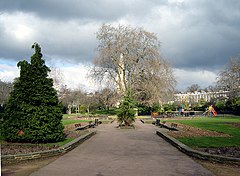
The London Borough of Islington is short of large parks and open spaces, given its status in recent decades as a desirable place of residence. In fact, Islington has the lowest ratio of open space to built-up areas of any London borough. The largest continuous open space in the borough, at 11.75 hectares, is Highbury Fields.

Lonsdale Square is a garden square in the Barnsbury district of Islington, North London. It is bounded by unusual Tudor Gothic Revival terraced houses, with picturesque gables and Elizabethan-style windows, and is probably unique among squares. All the houses are listed buildings. The central public garden contains flower beds and mature trees.

Finsbury Park is an area in north London, England, which grew up around an important railway interchange near the convergence of the Boroughs of Islington and Hackney and is named after the park in Haringey.

Caledonian Road in the London Borough of Islington, England, connects North London, from Camden Road near its junction with Holloway Road, and central London's Pentonville Road in the south. A a mile and a half long, it is known colloquially as the Cally and forms the entirety of the A5203.

The 2018 Islington London Borough Council election took place on 3 May 2018 to elect members of Islington London Borough Council in England. This was on the same day as other local elections. The council had previously had elections in 2014. The Labour Party retained control of the council, winning 47 of the 48 seats. The sole non-Labour councillor elected was Caroline Russell of the Green Party.