
The London Borough of Islington is a London borough which forms part of Inner London, England. Islington has an estimated population of 215,667. It was formed in 1965, under the London Government Act 1963, by the amalgamation of the metropolitan boroughs of Islington and Finsbury.

Islington is an inner-city area of north London, England, within the wider London Borough of Islington. It is a mainly residential district of Inner London, extending from Islington's High Street to Highbury Fields, encompassing the area around the busy High Street, Upper Street, Essex Road, and Southgate Road to the east.

An arcade is a succession of contiguous arches, with each arch supported by a colonnade of columns or piers. Exterior arcades are designed to provide a sheltered walkway for pedestrians; they include many loggias, but here arches are not an essential element. An arcade may feature arches on both sides of the walkway. Alternatively, a blind arcade superimposes arcading against a solid wall.

An alley or alleyway is a narrow lane, path, or passageway, often reserved for pedestrians, which usually runs between, behind, or within buildings in the older parts of towns and cities. It is also a rear access or service road, or a path, walk, or avenue in a park or garden.

The Angel, Islington, is a historic landmark and a series of buildings that have stood on the corner of Islington High Street and Pentonville Road in Islington, London, England. The land originally belonged to the Clerkenwell Priory and has had various properties built on it since the 16th century. An inn on the site was called the "Angel Inn" by 1614, and the crossing became generally known as "the Angel". The site was bisected by the New Road, which opened in 1756, and properties on the site have been rebuilt several times up to the 20th century. The corner site gave its name to Angel tube station, opened in 1901, and the surrounding Angel area of London.
Brixton Market comprises a street market in the centre of Brixton, south London, and the adjacent covered market areas in nearby arcades Reliance Arcade, Market Row and Granville Arcade.

Şişli is a municipality and district of Istanbul Province, Turkey. Its area is 10 km2, and its population is 276,528 (2022). Located on the European side of the city, it is bordered by Beşiktaş to the east, Sarıyer to the north, Eyüp and Kağıthane to the west, and Beyoğlu to the south. It is also the name of a specific area of Şişli district centered on the Sişli Mosque.

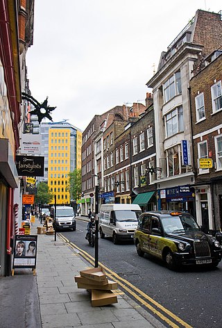
Upper Street is the main street of the Islington district of inner north London, and carries the A1 road. It begins at the junction of the A1 and Liverpool Road, continuing on from Islington High Street which runs from the crossroads at Pentonville Road and City Road and runs roughly northwards from outside the main entrance to Angel Underground station, then past the Business Design Centre, then splits at Islington Green, then past The Screen On The Green cinema, past Islington Town Hall, ending at Highbury & Islington tube station on Highbury Corner, where the A1 carries on as Holloway Road, part of the Great North Road.

The Adelaide Central Market is a major fresh produce market in Adelaide, South Australia. As one of the oldest markets in Australia, Adelaide Central Market has a large range of fresh food, including fruit and vegetables, meat and poultry, seafood, cheeses, baked goods, small goods, and health foods, along with several cafés and eateries. Currently, approximately one million kilograms of fresh produce are delivered to the market and sold every month. It is a popular tourist attraction in the city, with more than 8.5 million visitors every year. It is also referred to simply as the Central Market. A $400 million redevelopment of the adjacent Central Market Arcade was approved in January 2021, which will include a mixed-use 35-storey building comprising offices, residential apartments and a hotel.
Denmark Street is a street on the edge of London's West End running from Charing Cross Road to St Giles High Street. It is near St Giles in the Fields Church and Tottenham Court Road station. The street was developed in the late 17th century and named after Prince George of Denmark. Since the 1950s it has been associated with British popular music, first via publishers and later by recording studios and music shops. A blue plaque was unveiled in 2014 commemorating the street's importance to the music industry.

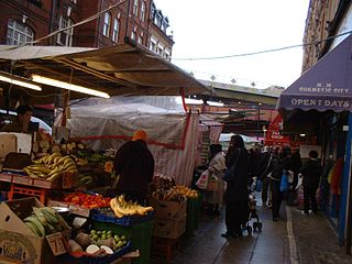
Exmouth Market is a semi-pedestrianised street in Clerkenwell in the London Borough of Islington, and the location of an outdoor street market of 32 stalls.

Queen's Market, also known as Queen's Road Market, and Green Street Market, is a historic street market in the London Borough of Newham. It lies adjacent to Green Street and Upton Park tube station.

Caledonian Road in the London Borough of Islington, England, connects North London, from Camden Road near its junction with Holloway Road, and central London's Pentonville Road in the south. A mile and a half long, it is known colloquially as the Cally and forms the entirety of the A5203.

Whitechapel High Street is a street in the Borough of Tower Hamlets in the East End of London. It is about 0.2 miles long, making it "one of the shortest high streets in London". It links Aldgate High Street to the south-west with Whitechapel Road to the north-east, and includes junctions with Commercial Street to the north and Commercial Road to the east.

Exchange Place, also known as Exchange Alley and Exchange Passage, is a pedestrian zone that was created in 1831 originally as a small street in the French Quarter of New Orleans, Louisiana. Its original name was Passage de la Bourse, or Exchange Passage. The street was commissioned by the banker and merchant Samuel Jarvis Peters, who thought to build an exchange closer to Canal Street. It was built in coherence with the Merchants' Exchange Building on Royal Street as it acted as a back entrance. The street has been a hidden alleyway to many shops and restaurants over the years.

The Melbourne central business district in Australia is home to numerous lanes and arcades. Often called "laneways", these narrow streets and pedestrian paths date mostly from the Victorian era, and are a popular cultural attraction for their cafes, bars and street art.

Angel is an area on the northern fringes of Central London within the London Borough of Islington. It is 2 miles (3.2 km) north-northeast of Charing Cross on the Inner Ring Road at a busy transport intersection. The area is identified in the London Plan as one of 35 major centres in London. It is a significant commercial and retail centre, and a business improvement district. Angel straddles the ancient boundary of the parishes of Clerkenwell and Islington that later became the metropolitan boroughs of Finsbury and Islington. It is named from the former Angel Inn which stood on the corner of Islington High Street and Pentonville Road. Since 1965 the whole area has formed part of the London Borough of Islington in Greater London.

260 Collins is a shopping centre completed in 2016, designed by ARM Architecture, located between Collins and Little Collins streets in Melbourne, Australia. The centre is located beneath a hotel occupying the upper nine floors.

Grimmaische Strasse is a street in Leipzig, borough Leipzig-Mitte, and connects the marketplace with Augustusplatz. It was named in 1839 after the Grimma Gate (Grimmaisches Tor), the gateway to Grimma, which was first mentioned in 1421. Before that it was called Grimmaische Gasse and was the main street of the Grimma quarter. Today it is a heavily frequented pedestrian zone in a prime location with department stores, shops, restaurants, hotels, a museum and the university as residents.


