This article's lead sectionmay be too short to adequately summarize the key points. Please consider expanding the lead to provide an accessible overview of all important aspects of the article.(March 2025)
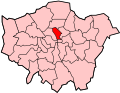
Wards of the United Kingdom are drawn for electoral purposes to give an equal electorate; here the Tufnell Park is in the south of a ward of 1916 named Tufnell.
Tufnell Park Road, a straight of 1.24 kilometres (0.77mi), was sometimes conjectured by historians to follow the line of a Roman track.[1] There is no evidence of Roman activity in the area and a supposed Roman camp marked on Dent's 1805 parish map has been shown by Museum of London Archaeology excavations to probably be a misidentified medieval moated site.[1] The road has for centuries been an east–west connector between the roads from the hearts of Islington and Camden which converge into a major northern route at Archway market place, across 500metres of Dartmouth Park district to the north.
Boundaries
North-east of Tufnell Park Road, the housing is closer to Upper Holloway railway station and so is popularly considered to be Upper Holloway district. On all other sides of the road is Tufnell Park based on nearest rail/tube station.
The road which Tufnell Park Road links have been greatly alleviated from sole principal status by diverting in the 20th century the A1 through Edgware where the M1 also runs instead of its old route through High Barnet, converging the route with the straighter A41 road from Marylebone. The A1 road in the east of Tufnell Park is therefore less arterial which reinforces the loss of its old name "the Great North Road", a historical coaching road. It specifically serves vehicles driven between the A1 or M1 and the City of London.[2][3]
Hackney Brook
Rising north of here at Mercers Road, Hackney Brook, culverted today, ran south to cross Holloway Road near Tufnell Park Road and then flowed to Lowman Road, where it turned north-east and ran along Gillespie Road to leave the traditional bounds of Islington at Mountgrove Road.[4]
Agricultural use
For centuries this northern part of the ancient parish of Islington was part of many square miles renowned for dairy farms which kept the City of London and neighbouring north and west parts supplied with milk.[5] It kept a rural air well into the 19th century in its important role as a base for a number of dairies supplying the capital. In 1753 the area became the property of William Tufnell who was granted the manor of Barnsbury by his father-in-law Sir William Halton. The manor house (now demolished) stood on the site of the large Odeon cinema at the end of Tufnell Park Road where it meets the A1 (Holloway Road).[6] The manor's gateposts survive along the west of Tufnell Park Road. Tufnell petitioned Parliament for authority to develop his estate but the building leases he was granted were left unused; his family had a set of rural estates nationwide.[n 1]
The Tufnell Park estate passed to his brother George Foster Tufnell, MP for Beverley (died 1798), then to George's son William Tufnell (died 1809), MP for Colchester, who married in 1804 heiress Mary Carleton (daughter of Thomas Carleton of South Carleton d.1829). Both are buried at St Mary's Islington, hence her maiden name appearing as two street names in N7.[n 2]
The manor then passed to Henry Tufnell (d. 1854), MP for Ipswich and Devonport, Liberal chief whip whose three marriages included two daughters of earls.[n 3]
The sparse remnants of the freehold passed to Henry Archibald Tufnell (d 1898) who died with no children, and then to Lt Col Edward Tufnell (d. 1909) HM Inspector of Schools, Factory Commissioner, Director Greenwich Hospital.[n 4]
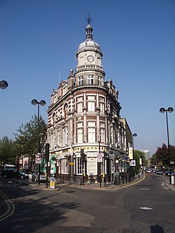
Serious building began in 1845 with a scheme sponsored by Henry Tufnell and designed by John Shaw Jr., who had laid out the Eton Estate in Chalk Farm. This initial work was largely limited to the area around Carleton Road. In 1865 the scheme was taken up by George Truefitt who developed most of the local villas and St. George's Church (1865), built for Anglican secessionists. The housing stock was of a solid nature, and Tufnell Park kept its good name until the end of the century. Charles Booth in his survey of London Life and Labour reported that the older streets (Anson Road and Carleton Road) housed a mixture of retired merchants and music hall artistes who were rich enough to holiday abroad over winter. He believed that second wave of building around Celia, Hugo, Corinne, Huddleston and Archibald Roads threatened to create a metropolis "from which the rich would soon be going". The private girls' school established at the corner of Carleton and Brecknock Roads ceased in 1878 after many of its pupils drowned in the Princess Alice disaster.
Whereas arterial roads and railway lines sliced through Kentish Town and Camden in the 19th century, one neat east–west double track skirts the district. Junction Road railway station was an 1872–1943 direct link with central London, superseded in 1907 by the building of the tube station Tufnell Park. The shabby genteel reputation of Tufnell Park made it a standard comic reference in the nineteenth and twentieth centuries. George and Weedon Grossmith locate their aspirational Mr Pooter in Tufnell Park (Upper Holloway) in Diary of a Nobody. Julian and Sandy, the camp BBC home service comedians, frequently referenced Tufnell Park as did The Guardian newspaper's Biff cartoon in the 1980s. Between 1999 and 2001, Tufnell Park was the location for Channel 4's comedy drama, Spaced.
The nearest London Overground and Thameslink stations are the same distance from the centre of the area (as defined by nearest station), in neighbouring districts equally named after their stations:
Kentish Town (Thameslink, located towards Camden) (also on the Northern Line)
Gospel Oak (Overground, located towards Hampstead)
London Buses routes 4, 134 and 390 as well as Night Bus N20 serve the area.
Tufnell Park Playing Fields
This 5-acre (2.0ha) space provide Islington's only full-size grass football pitch, shared by clubs. Adjoining this former home ground of Tufnell Park F.C., sectioned off are:
The cult sitcom Spaced, which was created, written by and starred Simon Pegg and Jessica Stevenson, is chiefly set in the area. The distinctive house at the fictional 23 Meteor Street is in fact on Carleton Road and was valued at £4,000,000 in 2018[8]
↑"Islington: Introduction", A History of the County of Middlesex: Volume 8, Islington and Stoke Newington Parishes, ed. A P Baggs, Diane K Bolton and Patricia E C Croot, pp. 1–3. British History Online http://www.british-history.ac.uk/vch/middx/vol8/pp1-3
↑William's father was Samuel Tufnell of Langleys in Essex. William also inherited Nun Monkton in Yorkshire and estates in Northumberland from his great-uncle, Nathaniel Payler. He also inherited Pleshy from his godfather William Joliffe. These estates went to his older brother John Jolliffe Tufnell of Langleys.
↑William was the brother of Lt. Col. John Charles Tufnell of Bath (leased Lackham House, Lacock, in Wiltshire in 1817), banker, m. 1796 Uliana Ivanova Margaret Fowell (d. 29/1/1848) daughter of John Fowell of Bishopbourne). They had 18 children, one of whom was Edward Wyndam Tufnell, the first Bishop of Brisbane.
↑m. 1. (married first) Anne Augusta Wilmot-Horton (daughter of the Governor of Ceylon, d. 17/9/1843), m. 2. 1844 Frances Byng (daughter of Sir John Byng, Earl of Stafford, d. 1846), m. 3. 1848 Lady Anne Primrose (daughter of Earl of Rosebery, d. 1862)
↑Edward Tufnell (d. 1909) m. 1846 Honoria Mary Macadam (daughter of Col. Macadam Knight of Hanover, d.1877)
This page is based on this Wikipedia article Text is available under the CC BY-SA 4.0 license; additional terms may apply. Images, videos and audio are available under their respective licenses.