Finchley is a large district of north London, England, in the London Borough of Barnet. Finchley is on high ground, 7 mi (11 km) north of Charing Cross. Nearby districts include: Golders Green, Muswell Hill, Friern Barnet, Whetstone, Mill Hill and Hendon.

Golders Green is an area in the London Borough of Barnet in England. It began as a medieval small suburban linear settlement near a farm and public grazing area green, and dates to the early 19th century. Its bulk forms a late 19th century and early 20th century suburb with a commercial crossroads. The rest is of later build. It is centred approximately 6 miles (9 km) north west of Charing Cross on the intersection of Golders Green Road and Finchley Road.

Hampstead is an area in London, England, which lies 4 miles (6 km) northwest of Charing Cross, forming the northwest part of the London Borough of Camden, a borough in Inner London. It borders Highgate and Golders Green to the north, Belsize Park to the south and is surrounded from the northeast by Hampstead Heath, a large, hilly expanse of parkland.

East Finchley is an area in North London, immediately north of Hampstead Heath. Like neighbouring Muswell Hill, it straddles the London Boroughs of Barnet and Haringey, with most of East Finchley falling into the London Borough of Barnet. It has the greenest high road in London.

West Hampstead is a London Underground station in West Hampstead. It is located on West End Lane between Broadhurst Gardens and Blackburn Road and is situated in Travelcard Zone 2. It is on the Jubilee line between Kilburn and Finchley Road stations. It is 100 m (110 yd) from West Hampstead station on the London Overground Mildmay line and 200 m (220 yd) from West Hampstead Thameslink station. Metropolitan line trains also pass through the station, but do not stop.
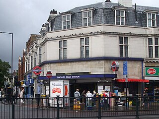
Finchley Road is a London Underground station at the corner of Finchley Road and Canfield Gardens in the London Borough of Camden, north London. It is served by the Jubilee and Metropolitan lines. On the Jubilee line, the station is between West Hampstead and Swiss Cottage stations. On the Metropolitan line, it is between Wembley Park and Baker Street stations. The station is in Travelcard Zone 2.

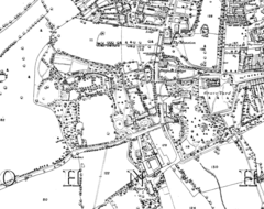
North Finchley is a suburb of London in the London Borough of Barnet, situated seven miles (11 km) northwest of Charing Cross. North Finchley is centred on Tally Ho Corner, the junction of the roads to East Finchley, Church End, Friern Barnet and Whetstone. Church End is usually known as Finchley Central, owing to the name of the tube station located there.

Swiss Cottage is an area of Hampstead in the London Borough of Camden, England. It is centred on the junction of Avenue Road and Finchley Road and includes Swiss Cottage tube station. Swiss Cottage lies 3.25 miles (5.23 km) north-northwest of Charing Cross. The area was named after a public house in the centre of it, known as "Ye Olde Swiss Cottage".
West Hampstead is an affluent area in the London Borough of Camden in north-west London. Mainly defined by the railway stations of the same name, it is situated between Childs Hill to the north, Frognal and Hampstead to the north-east, Swiss Cottage to the east, South Hampstead to the south-east and Kilburn to the west and south-west. The neighbourhood is mainly residential, with several local amenities, including a range of independent shops, supermarkets, restaurants, bars, cafes and bakeries; most of these are concentrated in the northern section of West End Lane and around West End Green. Located in travel zone 2, West Hampstead has excellent transport links, and is served by three stations: West Hampstead on the Jubilee line, West Hampstead Overground station and West Hampstead Thameslink station.
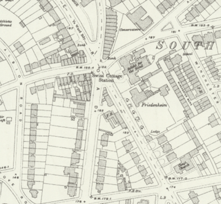
Swiss Cottage is a disused London Underground station in Swiss Cottage, north-west London. It was opened in 1868 as the northern terminus of the Metropolitan and St. John's Wood Railway (M&StJWR), the first northward branch extension from Baker Street of the Metropolitan Railway.
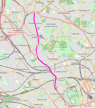
Finchley Road is a designated 4.5-mile (7-kilometre) arterial road in north-west London, England. The Finchley Road starts in St John's Wood near central London as part of the A41; its southern half is a major dual carriageway with high traffic levels often frequented by lorries and long-distance coaches as it connects central London, via the A41 Hendon Way, to the M1 motorway at Brent Cross and other roads at that interchange.

Belsize Park is a residential area of Hampstead in the London Borough of Camden, in the inner north-west of London, England.
Finchley Road & Frognal is a station on the Mildmay line of the London Overground, located on Finchley Road in the London Borough of Camden in north London. It is in Travelcard Zone 2. The station is about five minutes walk from Finchley Road tube station on the Metropolitan line and Jubilee line of the London Underground, and is marked as an official out-of-station interchange. The station was opened as Finchley Road St Johns Wood in 1860 on the Hampstead Junction Railway for the connection to the North London Railway.
South Hampstead is an affluent part of the London Borough of Camden in inner north London. It is commonly defined as the area between West End Lane in the west, the Chiltern Main Line (south), Broadhurst Gardens north and north-west followed by a non-road line demarcating the south slopes of Hampstead village, west of Belsize Park, and north and west of the usually narrowly defined Swiss Cottage neighbourhood. It takes in some of Fitzjohns Avenue leading up to "the village", but the exact amount is an arbitrary measure. The streets were laid out in the Victorian era. The area was not served by any railways until Loudoun Road station opened in 1879 on the street of that name.

Susan Elizabeth Garden, Baroness Garden of Frognal, PC is a British Liberal Democrat politician who, since 2018, serves as Deputy Speaker of the House of Lords.

St Mary's Church, formerly St Mary's Chapel, is a Grade II* listed Roman Catholic church in Hampstead, London, UK.

The London Borough of Camden is a borough in Inner London, England. Camden Town Hall, on Euston Road, lies 1.4 mi (2.3 km) north of Charing Cross. The borough was established on 1 April 1965 from the former metropolitan boroughs of Holborn, St Pancras and Hampstead.

Finchley Road was an authorised but unbuilt railway station in Frognal, north London planned by the Metropolitan and St John's Wood Railway (M&StJWR).
South Hampstead is a ward in the London Borough of Camden, in the United Kingdom. The ward covers the area of the same name and was first used for the 2022 Camden London Borough Council election, electing three councillors to Camden Council. Most of its area was previously in Swiss Cottage ward, which was abolished at the same time, although sections of Kilburn and West Hampstead wards have also been incorporated under the new boundaries. In 2018, the ward had an electorate of 8,904. The Boundary Commission projects the electorate to rise to 8,927 by 2025.