Stamford Hill is an area in Inner London, England, about 5.5 miles north-east of Charing Cross. The neighbourhood is a sub-district of Hackney, the major component of the London Borough of Hackney, and is known for its Hasidic community, the largest concentration of orthodox Ashkenazi in Europe.
The district takes its name from the eponymous hill, which reaches a height of 108 ft (33m) AOD,[2] and the originally Roman A10 also takes the name "Stamford Hill", as it makes its way through the area.
The hill is believed[3] to be named after the ford where the A10 crossed the Hackney Brook on the southern edge of the hill. Sanford and Saundfordhill are referred to in documents from the 1200s, and mean "sand Ford".[4]Roque's map of 1745 shows a bridge, which replaced the ford, referred to as "Stamford Bridge".[5]
The hill rises gently from the former course of the Hackney Brook to the south, and its steeper northern slope provided a natural boundary for the traditional (parish and borough) extent of Hackney, and now does so for the wider modern borough.
History
A map showing the Stamford Hill ward of Hackney Metropolitan Borough, as it appeared in 1916.
Stamford Hill lies on the old Roman road of Ermine Street, on the high ground where it meets the Clapton Road, which runs from central Hackney. By the 18th century, the Roman road (now numbered as the A10) was subject to heavy traffic, including goods wagons pulled by six or more horses, and this caused the surface of the road to deteriorate. The local parishes appealed to Parliament in 1713 for the right to set up a Turnpike Trust, to pay for repairs and maintenance. Gates were installed at Kingsland and Stamford Hill, to collect the tolls.[6]
Roque's map of 1745 shows a handful of buildings around the Turnpike, and by 1795, the A10 was lined with the large homes and extensive grounds of wealthy financiers and merchants attracted, in part, by the elevated position.[7]
Stamford Hill had a gibbet that was used to display the remains of criminals executed at Tyburn in the 1740s. In 1765, a map of the area showed the Gibbet Field south of the road from Clapton Common, behind Cedar House.[8]
The area remained essentially rural in character, and little more was built until the arrival of the railway in 1872,[7] and the tram system at about the same time. Stamford Hill was the point where the tram line coming north from the City[9] met the Hackney tram line,[10] and so, it became a busy interchange, with a depot opening in 1873.[11] Electrification commenced in 1902 and by 1924 a service was commenced between Stamford Hill and Camden Town along Amhurst Park.[12]
Stamford Hill had many eminent Jewish residents, including the Montefiore family. Italian-born Moses Vita Montefiore (died 1789) was living there in 1763. His son Joseph (died 1804) married Rachel Mocatta, and his grandson Abraham Montefiore (died 1824) married Henrietta, whose father, the financier Nathan Meyer Rothschild, lived near the modern Colberg Place from 1818 to 1835. The Montefiores' property a little further south was to be transformed by Abraham's grandson, Claude Montefiore, into Montefiore House school. With the increased development of the area, many distinguished families moved away: In 1842, there were few remaining of the wealthy Jews who had once settled in Hackney.[13] The philanthropist and abolitionistMP Samuel Morley had a residence here from about 1860. The gardening writer and cottage gardenerMargery Fish was born here in 1892.[14]
In 1926, the Union of Orthodox Hebrew Congregations was established in Stamford Hill, and this became a magnet for other strictly observant Jews, many fleeing Nazi persecution in the years before the Second World War.[13] Also, many Jewish families came to the area from other areas of London, refugees in their own way from bombing and post-war clearances for new housing. One of the early Hasidic leaders in Stamford Hill was the Shotzer Rebbe. The Hungarian uprising also led to an influx of Haredi Jews fleeing hardship under Soviet rule. Another notable Jewish resident, from 1955 until his death in 2000, was the spiritual head of the Union of Orthodox Hebrew Congregations, Rabbi Chanoch Dov Padwa.[citation needed]
Governance
Stamford Hill has never been an administrative area in its own right; it has always been an area of Hackney. Hackney was an administrative unit with consistent boundaries from the early Middle Ages to the creation of the larger modern borough in 1965. Hackney was based for many centuries on the Ancient Parish of Hackney.
The Ancient Parishes provided a framework for both civil (administrative) and ecclesiastical (church) functions, but during the nineteenth century, there was a divergence into distinct civil and ecclesiastical parish systems. In London, the Ecclesiastical Parishes sub-divided to better serve the needs of a growing population, while the Civil Parishes continued to be based on the same Ancient Parish areas.
The district's usual definition is based on the physical feature of the hill and the neighbourhood's location within the Ancient Parish and subsequent (with almost identical boundaries) Metropolitan Borough of Hackney.[3] It also reflects the fact that what was originally the Roman A10 also takes the name 'Stamford Hill' as goes over the hill between the brook and the borough boundary.
Western boundary with Stoke Newington: Takes part of the AP\MB of Hackney's boundary with the AP\MB of Stoke Newington along Bethune Road and down to the A10.[22]
Southern Boundary with West Hackney: The east–west course of the Hackney Brook, which may have been as wide as 22m at this point,[23] provided a natural southern boundary for the district, however the river was culverted and it is now difficult to discern its former course on the ground. This has led to very ambiguous boundary, along its former course, in the Cazenove\Northwold Road area.
East and south-east boundary with Upper Clapton:Upper Clapton is also part of Hackney and shares much of the eastern side of the hill. There is little tradition of a particular border. The post code boundary is sometimes used but this is arbitrary: post code areas are not intended to define districts.
Demography
The high fertility of the Haredi community contributes to the area having one of highest birthrates in the UK, with a crude birth rate of more than 25 per 1,000 of the population, twice the UK average.[24]
The data table shows 2011 ONS Census data[25] for the wards around Stamford Hill, where respondents indicated a religion:[26]
The London Borough of Hackney has expressed its concern that Haredi Jewish residents are seriously under-counted in the Census data, as the religion question is voluntary.[27]
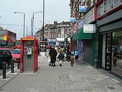
Stamford Hill is at the centre of an Ashkenazistrictly-Orthodox Jewish, and predominantly Hasidic, community estimated to be some 15,000 strong, and growing at a rate of around 5% each year.[28][29] It is the largest Hasidic community in Europe, and referred to as a square mile of piety,[13] reflecting the many Jewish men seen walking in their distinctive clothes on their way to and from worship. The congregations often represent historical links with particular areas of Eastern Europe in their dress and their worship. Many also retain links with congregations around the world. The largest of these congregations is the Satmar dynasty, which has five directly associated synagogues; Belz is another large community, with four synagogues. As well as Stamford Hill's own Jewish population, there are also many observant Jews in neighbouring Upper Clapton, West Hackney, Stoke Newington, and Tottenham; there may be as many as 80 synagogues in this wider area.[citation needed]
A volunteer emergency response first-aid service called Hatzola (the Hebrew word for rescue) and a volunteer community watch group called Shomrim[30] (the Hebrew word for watchmen) are run by, and largely for, the Jewish community.[31]
The strictly Orthodox Jewish community relies mostly on private education for schooling, with almost all Jewish children attending private, single-sex Jewish schools.[32] In 2005, the Stamford Hill Yesodey Hatorah Senior Girls' School achieved voluntary-aided status.[33] In 2014, the Oxford, Cambridge, and RSA (OCR) Exam board, having conducted an investigation into alleged exam malpractice, concluded that the school had redacted questions involving the evolution of species on GCSE science exam questions.[34][35]Ofqual subsequently ruled that blocking out exam questions is malpractice, and, accordingly, not permissible.[36] The same year, it was reported by the BBC that many of the yeshivas in the area "usually don't provide any maths, English or science" classes and were operating "without the most basic health, safety, and child welfare checks".[37] In an article on Stamford Hill yeshivas, The Daily Telegraph cited government documents obtained by Channel 4's Dispatches and the Jewish Chronicle as saying that between 800 and 1000 boys aged between 13 and 16 are "missing" from the school system in the borough of Hackney alone.[38][39]
Haredi families, on average, have 5.9 children, almost 2.5 times the average for England and Wales, and many families live in over-crowded flats.[40] National planning policy and guidance are applied by the local council, prohibiting development of family housing. This has led to conflict between the council and the Jewish population, sometimes represented by the Union of Orthodox Hebrew Congregations. Agudas Israel Housing Association is active in developing housing for the Jewish community in Stamford Hill.[32]
There is also a notable population of Yemenite Jews, especially Adeni Jews who originated in the port city of Aden in Yemen. They settled in Stamford Hill, after fleeing anti-Jewish violence at the end of the Aden Protectorate. The Adeni Congregation synagogue, Nahalat Yosef, is named after the original Adeni synagogue in Yemen.[41] A further wave of immigration of Yemenite Jews occurred in the 1990s and 2000s when several families escaped antisemitic persecution from Houthis in the north of Yemen.[42]
In 2014, the community met with controversy after a sign was spotted in the location reading, "Women should please walk along this side of the road only".[43] The sign was reportedly put up for a Torah Procession parade, and was meant to provide directions for members who wished to avoid contact with the opposite sex.[43] After complaints about the sign were raised, a group of Shomrim who regularly police the area contacted the organisers to tell them that the posters "lacked explanation". The posters were removed, and the organisers agreed to take the signs down more quickly the following year.[44]
Since the 2011 census, there has been a migration of Stamford Hill Hasidic Jews to Canvey Island, in Essex. Canvey Island has a fairly homogenous ethnic make-up, and did not previously have a significant Jewish presence, but community relations appear to be good, and were the subject of a TV documentary.[45]
The Jesuit order founded St Ignatius' College, nearby, at the foot of the hill, on High Road, Tottenham, in 1894,[46] The school consisted of two houses called Morecombe Lodge and Burleigh House. In 1907, the college was recognised by the Board of Education, and began to receive public money. Notable former pupils of St Ignatius include Alfred Hitchcock and Cardinal Heenan. It remained as a grammar school until 1968, and then became a two-form entry comprehensive school, the Lower School being located at the old Cardinal Allen School in Enfield, and the Upper School in new premises at Turkey Street, Enfield.
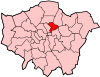
The London Borough of Hackney is a London borough in Inner London, England. The historical and administrative heart of Hackney is Mare Street, which lies 5 miles (8 km) north-east of Charing Cross. The borough is named after Hackney, its principal district. Southern and eastern parts of the borough are popularly regarded as being part of east London that spans some of the traditional East End of London with the northwest belonging to north London. Its population is estimated to be 281,120.
Dalston is an area of East London, in the London Borough of Hackney. It is four miles northeast of Charing Cross. Dalston began as a hamlet on either side of Dalston Lane, and as the area urbanised the term also came to apply to surrounding areas including Kingsland and Shacklewell, all three of which being part of the Ancient Parish of Hackney.
Stoke Newington is an area in the northwest part of the London Borough of Hackney, England. The area is five miles northeast of Charing Cross. The Manor of Stoke Newington gave its name to Stoke Newington, the ancient parish.
The Metropolitan Borough of Hackney was a metropolitan borough of the County of London from 1900 to 1965. Its area became part of the London Borough of Hackney.
The Metropolitan Borough of Stoke Newington was a metropolitan borough in the County of London between 1900 and 1965 when it became part of the London Borough of Hackney.
Lea Bridge is a district in the London Borough of Hackney and the London Borough of Waltham Forest in London, England. It lies 7 miles (11.3 km) northeast of Charing Cross.
Hackney North and Stoke Newington is a constituency represented in the House of Commons of the United Kingdom since 1987 by Diane Abbott, a member of the Labour Party who served as Shadow Home Secretary from 6 October 2016 to 5 April 2020. Abbott was one of the first three Black British MPs elected, and the first female Black British MP in the UK.
Shacklewell is a small locality to the east of Roman Ermine Street, in the London Borough of Hackney.
Stoke Newington was an ancient parish in the county of Middlesex. It was both a civil parish, used for administrative purposes, and an ecclesiastical parish of the Church of England.
Hackney was a parish in the historic county of Middlesex. The parish church of St John-at-Hackney was built in 1792, replacing the nearby former 16th-century parish church dedicated to St Augustine. The original tower of that church was retained to hold the bells until the new church could be strengthened; the bells were finally removed to the new St John's in 1854. See details of other, more modern, churches within the original parish boundaries below.
Hackney North was a parliamentary constituency in "The Metropolis". It returned one Member of Parliament (MP) to the House of Commons of the Parliament of the United Kingdom.
Hackney South was a parliamentary constituency in "The Metropolis". It was represented by nine Members of Parliament to the House of Commons of the Parliament of the United Kingdom, only two of whom, Horatio Bottomley and Herbert Morrison, were elected more than once.
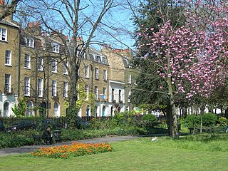
Clapton Square is the second largest garden square in the London Borough of Hackney, located in Lower Clapton, Clapton. It is lined by buildings on three sides. Its Conservation Area designated in 1969 – extended in 1991 and 2000 – takes in a larger green space separated by a stretch of open road: St John's Gardens. Those gardens have the tallest and largest building visible from all parts of the square's garden, the Church of St John-at-Hackney, rebuilt in 1792-97 which contains older monuments. Two sides of the square are lined with tall, partly stone-dressed, classical, Georgian terraced houses.
Shmira or Shomrim are organizations of proactive volunteer Jewish civilian patrols which have been set up in Haredi communities in neighborhoods across the United States, Canada, the United Kingdom, Israel, Belgium, and Australia to combat burglary, vandalism, mugging, assault, domestic violence, nuisance crimes and antisemitic attacks, and to help and support victims of crime. They also help locate missing people.
The Dalston Synagogue was an Orthodox Jewish congregation and synagogue, located on Poet's Road, Canonbury, in the Borough of Islington, North London, England, in the United Kingdom. After formation in 1874, the congregation worshiped in the Poet's Road synagogue from 1885 until its closure in 1967. The congregation worshiped in the Ashkenazi rite.
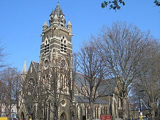
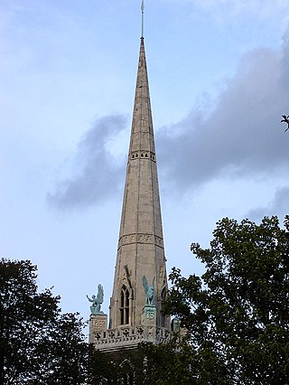
St Andrew, Stoke Newington, is a Grade II* listed Anglican parish church on Bethune Road in Stamford Hill, in the London Borough of Hackney, England. The church, which is dedicated to St Andrew, is located at the junction of Bethune Road and Dunsmure Road in London N16.
West Hackney is a district in the London Borough of Hackney, situated on the eastern side of Ermine Street, the major Roman Road better known as the A10.
Hackney is a district in East London, England, forming around two-thirds of the area of the modern London Borough of Hackney, to which it gives its name. It is 4 miles (6.4 km) northeast of Charing Cross and includes part of the Queen Elizabeth Olympic Park. Historically it was within the county of Middlesex.
Clapton is a district of east London, England, in the London Borough of Hackney.
1 2 The London Encyclopaedia, Weinreb and Hibbert, 1983
↑ "Hackney: Newington and Stamford Hill." A History of the County of Middlesex: Volume 10, Hackney. Ed. T F T Baker. London: Victoria County History, 1995. 38-44. British History Online. Web. 15 December 2018. http://www.british-history.ac.uk/vch/middx/vol10/pp38-44.
↑ The North Metropolitan Tramways Co. inaugurated 1872, and ran from Moorgate via Kingsland and Stoke Newington Roads to Stamford Hill
↑ The North Metropolitan from Bishopsgate ran through Mare Street, and thence to Clapton, opened in 1872, and was extended to Clapton Common in 1875, reaching Stamford Hill in 1902,
↑ 'Hackney: Communications', in A History of the County of Middlesex: Volume 10, Hackney, ed. T F T Baker (London, 1995), pp. 4-10. British History Online http://www.british-history.ac.uk/vch/middx/vol10/pp4-10 [accessed 23 December 2022].
↑ 'The Physique of Middlesex', in A History of the County of Middlesex: Volume 1, Physique, Archaeology, Domesday, Ecclesiastical Organization, the Jews, Religious Houses, Education of Working Classes To 1870, Private Education From Sixteenth Century, ed. J S Cockburn, H P F King, K G T McDonnell( London, 1969), British History Online https://www.british-history.ac.uk/vch/middx/vol1/pp1-10 [accessed 22 January 2025].
↑ The synagogues are named for the book Nahalat Yosef by Shemu'el Yosef Yeshuah. The book is named for his father, but contains a systematic exposition of rabbinical law and ethics. A second part details his travels in Palestine and the particular customs of Adeni Jews. In The Jews of the British Crown Colony of Aden, Reuben Ahroni, pp. 170–1 (Brill, 1994) ISBN90-04-10110-1
This page is based on this Wikipedia article Text is available under the CC BY-SA 4.0 license; additional terms may apply. Images, videos and audio are available under their respective licenses.