Wenlock Basin

Last updated

Looking North up Wenlock Basin towards its junction with Regent's Canal, July 2008 Wenlock basin north.JPG
Looking North up Wenlock Basin towards its junction with Regent's Canal, July 2008
Looking South down Wenlock Basin towards the Barbican Estate towers, July 2008 Wenlock basin south.JPG
Looking South down Wenlock Basin towards the Barbican Estate towers, July 2008
Regents Canal Basins
BSicon uCONTg.svg
To Paddington
BSicon BHFq.svg
BSicon uSTR.svg
BSicon tSTRq.svg
Kings Cross Station
BSicon RAq.svg
BSicon uSKRZ-Au.svg
A5200 York Way
BSicon uDOCKl.svg
BSicon uFABZgr+r.svg
Battlebridge Basin
BSicon RAq.svg
BSicon uSKRZ-Au.svg
A5203 Caledonian Road
BSicon utSTRa.svg
BSicon FEATURE.svg
BSicon utSTR.svg
Pentonville
BSicon utSTR.svg
Islington Tunnel (960 yd)
BSicon RAq.svg
BSicon RAq.svg
BSicon utSTR.svg
A1/Islington High Street
BSicon utSTRe.svg
BSicon uSKRZ-Eu.svg
Danbury Road bridge
BSicon uFGATEu.svg
City Road Lock
BSicon uDOCKl.svg
BSicon uFABZgr+r.svg
City Road Basin
BSicon uSKRZ-Eu.svg
Wharf Road bridge
BSicon uDOCKl.svg
BSicon uFABZgr+r.svg
Wenlock Basin
BSicon uSKRZ-Eu.svg
Packington Square footbridge
BSicon uFGATEu.svg
Sturts Road Lock
BSicon RAq.svg
BSicon uSKRZ-Au.svg
A1200 New North Road Bridge
BSicon uCONTf.svg
To Limehouse

The Wenlock Basin, is a 320 metre long canal basin on the Regent's Canal, in the Hoxton area of the London Borough of Hackney, United Kingdom. The City Road Basin lies just to the west of Wharf Road and is in the neighbouring London Borough of Islington.

Contents

There are private residential moorings [1] at the North end, with their own entrance gate and entryphone on Wharf Road. The basin itself narrows considerably towards the South - and is not deep enough to be navigable by anything other than canoe.

Unlike the Regent's Canal and City Road Basin, Wenlock Basin is not owned or managed by the Canal & River Trust. [2]

History

The basin was constructed in 1826 and is close to the entrance of the Islington Tunnel, where a tug service operated until the 1930s. The opening of the basin went badly wrong, with the cofferdam separating it from the Canal collapsing, prematurely filling the basin and leading to the water level of the canal falling by 13 inches. Traffic on the canal was halted until rainfall could restore the water levels. [3]

The basin took the name of Wenlock Barns, a local farm. [4] The name Wenlock was used by an electoral ward of the former Metropolitan Borough of Shoreditch, it was also, for a time, the name of a ward in the London Borough of Hackney.

A map showing the wards of Shoreditch Metropolitan Borough as they appeared in 1916. Shoreditch Met. B Ward Map 1916.svg
A map showing the wards of Shoreditch Metropolitan Borough as they appeared in 1916.

Residential developments

Wenlock Basin is accessible only to residents. The development consists of the following buildings:

Businesses

While no longer serving the original cargo handling and warehousing business, a number of modern businesses have office space on Wenlock Basin, either in the ground floor business units of the larger residential developments - or in their own property directly backing on to the basin. They include the Victoria Miro Gallery, a leading British contemporary art gallery in London run by Victoria Miro, and the British Ecological Society, a learned society in the field of Ecology.

WenlockStitch.jpg

See also

Related Research Articles

<span class="mw-page-title-main">Hoxton</span> Neighbourhood in the East End of London, England

Hoxton is an area in the London Borough of Hackney, England. As a part of Shoreditch, it is often considered to be part of the East End – the historic core of wider East London. It was historically in the county of Middlesex until 1889. It lies immediately north of the City of London financial district, and was once part of the civil parish and subsequent Metropolitan Borough of Shoreditch, prior to its incorporation into the London Borough of Hackney.

<span class="mw-page-title-main">Shoreditch</span> Human settlement in England

Shoreditch is a district in the East End of London in England, and forms the southern part of the London Borough of Hackney. Neighbouring parts of Tower Hamlets are also perceived as part of the area.

<span class="mw-page-title-main">Islington</span> District of London, England

Islington is a district in the north of Greater London, England, and part of the London Borough of Islington. It is a mainly residential district of Inner London, extending from Islington's High Street to Highbury Fields, encompassing the area around the busy High Street, Upper Street, Essex Road, and Southgate Road to the east.

<span class="mw-page-title-main">City Road</span> Street in London

City Road or The City Road is a road that runs through central London. The northwestern extremity of the road is at Angel where it forms a continuation of Pentonville Road. Pentonville Road itself is the modern name for the eastern part of London's first bypass, the New Road from Paddington to Islington, which was constructed in 1756. The City Road was built in 1761 as a continuation of that route to the City of London.

<span class="mw-page-title-main">Regent's Canal</span> Canal in England

Regent's Canal is a canal across an area just north of central London, England. It provides a link from the Paddington Arm of the Grand Union Canal, 550 yards (500 m) north-west of Paddington Basin in the west, to the Limehouse Basin and the River Thames in east London. The canal is 8.6 miles (13.8 km) long.

<span class="mw-page-title-main">Paddington Basin</span> Canal basin in Paddington, London, England

Paddington Basin is the name given to a long canal basin, and its surrounding area, in Paddington, London.

<span class="mw-page-title-main">Salford Quays</span> Area of Salford, Greater Manchester, England

Salford Quays is an area of Salford, Greater Manchester, England, near the end of the Manchester Ship Canal. Previously the site of Manchester Docks, it faces both Manchester and Trafford across the canal.

<span class="mw-page-title-main">The Wenlock Arms</span> Pub in Hoxton, London

The Wenlock Arms is a public house in Hoxton, in London's East End, which began trading in 1787. The pub is located halfway between Old Street and Angel, just off the City Road and the City Road Basin and Wenlock Basin on the Regent's Canal. The pub has won awards for the quality and range of its cask ales.

<span class="mw-page-title-main">De Beauvoir Town</span> Human settlement in England

De Beauvoir Town is a neighbourhood in east London and is in the London Borough of Hackney, 2 miles (3.2 km) north of the City of London. The area was a part of the Hackney; the Ancient Parish and subsequent Metropolitan Borough that was incorporated into the larger modern borough. It is sometimes described as a part of Dalston, which is in turn, also a part of the former parish and borough of Hackney.

<span class="mw-page-title-main">Parks and open spaces in the London Borough of Hackney</span>

The London Borough of Hackney, one of the inner London boroughs, has 62 parks, gardens and open spaces within its boundaries, totalling 330 ha. These provide the "green lungs" for leisure activities. Hackney Marshes contain the largest concentration of football pitches in Europe.

<span class="mw-page-title-main">Old Ford</span> Human settlement in England

Old Ford is an area in the London Borough of Tower Hamlets that is named after the natural ford which provided a crossing of the River Lea.

<span class="mw-page-title-main">Paddington Waterside</span> Development in London, England

Paddington Waterside is a developed area around Paddington Station in London.

<span class="mw-page-title-main">Kings Place</span> Building in London

Kings Place is a building in London’s Kings Cross area, providing music and visual arts venues combined with seven floors of office space. It has housed the editorial offices of The Guardian newspaper since December 2008 and is the former headquarters of Network Rail and CGI.

<span class="mw-page-title-main">Kingsland Basin</span>

Kingsland Basin is a canal basin in the De Beauvoir Town area of the London Borough of Hackney. The basin, which is also known as Kingsland Road Basin, dates from 1822 and is part of the Regents Canal.

<span class="mw-page-title-main">City Road Basin</span> Canal basin in London

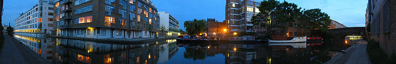
The City Road Basin is an English canal basin and part of the Regent's Canal in Central London, owned by the Canal & River Trust. It opened in 1820, and made a large contribution to the prosperity of the Regent's Canal. By the 1950s, its surroundings were largely derelict, but a programme of regeneration began in 2004, involving several large-scale residential developments, and public access to the basin was provided for the first time in 2009. The basin is used for canoeing by the Islington Boat Club.

<span class="mw-page-title-main">City Road Lock</span> Lock on the Regents Canal, London

City Road Lock is a lock on the Regent's Canal, in the London Borough of Islington, England. It is located a short distance to the east of Islington Tunnel, and immediately to the west of City Road Basin.

<span class="mw-page-title-main">Haggerston</span> Human settlement in England

Haggerston is a locale in East London, England, centred approximately on Great Cambridge Street. It is within the London Borough of Hackney and is considered to be a part of London's East End. It is about 3.1 miles (5 km) northeast of Charing Cross.

<span class="mw-page-title-main">Angel, London</span> Human settlement in England

Angel is an area on the northern fringes of Central London within the London Borough of Islington. It is 2 miles (3.2 km) north-northeast of Charing Cross on the Inner Ring Road at a busy transport intersection. The area is identified in the London Plan as one of 35 major centres in London. It is a significant commercial and retail centre, and a business improvement district. Angel straddles the ancient boundary of the parishes of Clerkenwell and Islington that later became the metropolitan boroughs of Finsbury and Islington. It is named from the former Angel Inn which stood on the corner of Islington High Street and Pentonville Road. Since 1965 the whole area has formed part of the London Borough of Islington in Greater London.

<span class="mw-page-title-main">Battlebridge Basin</span>

Battlebridge Basin is a canal basin in King's Cross, in the London Borough of Islington. It is located off the Regent's Canal.

References

  1. Canal Museum: Advice on Moorings in London
  2. British Waterways, London: May 2008
  3. Web page on the history of the basin https://www.wenlockhouseboatco.com/history-of-regents-canal-wenlock-basin.html
  4. web link to a map of the manor of Wenlock Barn http://www.bl.uk/onlinegallery/onlineex/crace/a/007000000000016u00009000.html
  5. Wilson, Mary (11 October 2007). "Luxuty apartments: the me, me, me flat". The Daily Telegraph . Retrieved 22 December 2016.
  6. Union Wharf: Residents association
  7. Persimmon Homes: Property developers
  8. Telford Homes: Estilo Development
  9. Housing Design Awards 2008: Shortlisted Completed Schemes
  10. Londonewcastle: Property developer
  11. Modern City Living: Property developer
  12. Wenlock Building: Sales Website

Coordinates: 51°31′56″N0°05′45″W / 51.532349°N 0.095714°W / 51.532349; -0.095714