Paddington

Last updated

Paddington
St Mary's Hospital old section 2003-08-22.jpg
Greater London UK location map 2.svg
Red pog.svg
Paddington
Location within Greater London
OS grid reference TQ267814
London borough
Ceremonial county Greater London
Region
Country England
Sovereign state United Kingdom
Post town LONDON
Postcode district W2, W9
Dialling code 020
Police Metropolitan
Fire London
Ambulance London
UK Parliament
London Assembly
List of places
UK
England
London
51°31′02″N0°10′23″W / 51.5172°N 0.1730°W / 51.5172; -0.1730

Paddington is an area in the City of Westminster, in central London, England. [1] A medieval parish then a metropolitan borough, it was integrated with Westminster and Greater London in 1965. Paddington station, designed by the engineer Isambard Kingdom Brunel opened in 1847. It is also the site of St Mary's Hospital and the former Paddington Green Police Station.

Contents

Paddington Waterside aims to regenerate former railway and canal land. Districts within Paddington are Maida Vale, Westbourne and Bayswater including Lancaster Gate.

History

A map showing the wards of Paddington Metropolitan Borough as they appeared in 1916. Paddington Met. B Ward Map 1916.svg
A map showing the wards of Paddington Metropolitan Borough as they appeared in 1916.

The earliest extant references to Padington (or "Padintun", as in the Saxon Chartularies, 959 [2] ), historically a part of Middlesex, appear in documentation of purported tenth-century land grants to the monks of Westminster by Edgar the Peaceful as confirmed by Archbishop Dunstan. However, the documents' provenance is much later and likely to have been forged after the 1066 Norman conquest. There is no mention of the place (or Westbourne or Knightsbridge) in the Domesday Book of 1086. [3]

It has been reasonably speculated that a Saxon settlement led by the followers of Padda, an Anglo-Saxon chieftain, was located around the intersection of the northern and western Roman roads, corresponding with the Edgware Road (Watling Street) and the Harrow and Uxbridge Roads. [4] [5] From the tenth century, Paddington was owned by Westminster Abbey which was later confirmed by the Plantagenet kings in a charter from 1222. This charter mentions a chapel and a farm situated in the area. [5] While a 12th-century document cited by the cleric Isaac Maddox (1697–1759) establishes that part of the land was held by brothers "Richard and William de Padinton". [6] They and their descendants carried out activities in Paddington; these were known by records dating from 1168 to 1485. They were the earliest known tenant farmers of the land. [5]

During King Henry VIII's dissolution, the property of Paddington was seized by the crown. However, King Edward VI granted the land to the Bishop of London in 1550. Successive bishops would later lease farmlands to tenants and city merchants. One such, in the 1540s was Thomas North who translated Plutarch's Parallel Lives into English in 1579. Shakespeare would later use this work and was said to have performed in taverns along Edgware Road. [5]

In the later Elizabethan and early Stuart era, the rectory, manor and associated estate houses were occupied by the Small (or Smale) family. Nicholas Small was a clothworker who was sufficiently well connected to have Holbein paint a portrait of his wife, Jane Small. Nicholas died in 1565 and his wife married again, to Nicholas Parkinson of Paddington who became master of the Clothworkers' Company. Jane Small continued to live in Paddington after her second husband's death, and her manor house was big enough to have been let to Sir John Popham, the attorney general, in the 1580s. They let the building that became in this time Blowers Inn. [7]

Early Modern period

As the regional population grew in the 17th century, Paddington's ancient Hundred of Ossulstone was split into divisions; Holborn Division replaced the hundred for most administrative purposes. [8] A church, the predecessor of St Mary was built in Paddington in 1679. [9]

St Mary on Paddington, a Georgian church commissioned in 1788 St Mary's Church, Paddington Green, W2 - geograph.org.uk - 351966.jpg
St Mary on Paddington, a Georgian church commissioned in 1788

In 1740, John Frederick leased the estate in Paddington and it is from his granddaughters and their families that many of Paddington's street names are derived. [5] The New Road was built in 1756–7 to link the villages of Paddington and Islington. [10] :260 By 1773, a contemporary historian felt and wrote that "London may now be said to include two cities (London and Westminster), one borough (Southwark) and forty six antient [ancient] villages [among which]... Paddington and [adjoining] Marybone (Marylebone)." [9] During the 18th century, several French Huguenots called Paddington village home. These included jewellers, nobility and skilled craftsmen; and men such as Claudius Amyand (surgeon to King George II). The French nobility built magnificent gardens that lasted up until the 19th century. [5]

Roman roads formed the parish's northeastern and southern boundaries from Marble Arch: Watling Street (later Edgware Road) and; (the) Uxbridge road, known by the 1860s in this neighbourhood as Bayswater Road. They were toll roads in much of the 18th century, before and after the dismantling of the permanent Tyburn gallows "tree" at their junction in 1759 a junction now known as Marble Arch. [11] :p.174 The Tyburn gallows might have been a reason why expansion and urban development (from London) slowed in Paddington; as public execution was taking place there up until 1783. [5]

Paddington station first opened in 1838 Departure platforms Paddington station.jpg
Paddington station first opened in 1838

Only in 1801 did major construction to Paddington occur. This happened when the bishops leased land to the Grand Junction Canal, where a direct trade link could now take place between London and the Midlands, bringing more employment to the area. The canal would remain dominant until Regent's Canal was built in 1820. Construction and building projects would take place from east to west and south to north throughout the 19th century; increasing its population in a rapid pace, overtaking the village scene of Paddington. This population increase would go from 1,881 to 46,305 between 1801 and 1851 respectively; with 10,000 new inhabitants added every decade thereafter. [5]

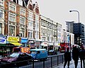
Paddington station first opened in 1838, with the first underground line in 1863 (Metropolitan). [5] Paddington was one of the few districts in London that had a migrant majority population by 1881. [10] :416 With a thriving Greek and Jewish community present in the mid-19th century. During the period, several Victorian churches were demolished owing to structural decay. Victorian housing developed into slums, giving the area an unsavoury reputation.

However, in the 1930s massive rebuilding and improvements projects were made. However, even as late as the 1950s Paddington was a byword for overcrowding, poverty and vice. Between the 1960s and 1980s, the area would see vast improvements and redevelopments in city planning. [5]

Tyburnia

The southeast section of Tyburnia used to be a shanty-town in the 1790s before the Canal was built and brought much needed employment to its inhabitants. The area was built up during the course of the Napoleonic Wars. [5]

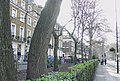
In the 19th century the part of the parish most sandwiched between Edgware Road and Westbourne Terrace, Gloucester Terrace and Craven Hill, bounded to the south by Bayswater Road, was known as Tyburnia. The district formed the centrepiece of an 1824 masterplan by Samuel Pepys Cockerell to redevelop the Tyburn Estate (historic lands of the Bishop of London) into a residential area to rival Belgravia. [12]

The area was laid out in the mid-1800s when grand squares and cream-stuccoed terraces started to fill the acres between Paddington station and Hyde Park; however, the plans were never realised in full. Despite this, Thackeray described the residential district of Tyburnia as "the elegant, the prosperous, the polite Tyburnia, the most respectable district of the habitable globe." [13]

Etymology

Derivation of the name is uncertain. Speculative explanations include Padre-ing-tun (explained as "father's meadow village"), Pad-ing-tun ("pack-horse meadow village"), [14] and Pæding-tun ("village of the race of Pæd") [15] the last being the cited suggestion of the Victorian Anglo-Saxon scholar John Mitchell Kemble.

There is another Paddington in Surrey, recorded in the Domesday Book as "Padendene" [16] and later as "Paddingdon", perhaps to be derived from Old English dene, denu "valley", whereas Paddington in Middlesex is commonly traced back to Old English tūn "farm, homestead, town". Both place names share the same first part, a personal name rendered as Pad(d)a, of uncertain origin, giving "Padda's valley" for the place in Surrey and "homestead of Padda's people" for the place in Middlesex. [2] That both place names would refer to the same individual or ancient family, [17] is pure speculation. A lord named Padda is named in the Domesday Book, associated with Brampton, Suffolk. [18]

Colloquial expressions

An 18th-century dictionary gives "Paddington Fair Day. An execution day, Tyburn being in the parish or neighbourhood of Paddington. To dance the Paddington frisk; to be hanged." [19] Public executions were abolished in England in 1868. [20]

Geography

The Paddington district is centred around Paddington railway station. The conventional recognised boundary of the district is much smaller than the longstanding pre-mid-19th century parish. That parish was virtually equal to the borough abolished in 1965. It is divided from a northern offshoot Maida Vale by the Regent's Canal; its overlap is the artisan and touristic neighbourhood of Little Venice. In the east of the district around Paddington Green it remains divided from Marylebone by Edgware Road (as commonly heard in spoken form, the Edgware Road). In the south west it is bounded by its south and western offshoot Bayswater. A final offshoot, Westbourne, rises to the north west.

Governance

An 1834 map of the Parliamentary Borough of St Marylebone, showing Paddington in (green) and St Pancras (yellow). These Parliamentary Boroughs, like the subsequent Metropolitan Boroughs used the ancient parish boundaries. LONDON, MARYLEBONE by BARTLETT, F.A. and B.J. DAVIES.jpg
An 1834 map of the Parliamentary Borough of St Marylebone, showing Paddington in (green) and St Pancras (yellow). These Parliamentary Boroughs, like the subsequent Metropolitan Boroughs used the ancient parish boundaries.
The former Paddington Town Hall Paddington Town Hall, Kilburn.jpg
The former Paddington Town Hall

Paddington was part of the Metropolitan Borough of Paddington, the headquarters of which was at Paddington Town Hall, until 1965 when the area became part of the enlarged City of Westminster. [21]

Landmarks

Browning's Pool

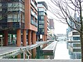
A lagoon created in the 1810s at the convergence of the Paddington Arm of the Grand Union Canal, the Regent's Canal and the Paddington Basin. It is an important focal point of the Little Venice area. It is reputedly named after Robert Browning, the poet. More recently known as the "Little Venice Lagoon" it contains a small islet known as Browning's Island. Although Browning was thought to have coined the name "Little Venice" for this spot there are strong arguments Lord Byron was responsible. [22]

London Paddington Station

Paddington station is the iconic landmark associated with the area. In the station are statues of its designer, Isambard Kingdom Brunel, and the children's fiction character Paddington Bear.

Paddington Basin

The terminus of the Paddington Arm of the Grand Union Canal was originally known as the Paddington Basin and all the land to the south was developed into housing and commercial property and titled The Grand Junction Estate. The majority of the housing was bounded by Praed Street, Sussex Gardens, Edgware Road and Norfolk Place. Land and buildings not used for the canal undertaking remained after 1929 with the renamed Grand Junction Company, which functioned as a property company. While retaining its own name, it was taken over in 1972 by the Amalgamated Investment and Property Company, which went into liquidation in 1976. Prior to the liquidation the Welbeck Estate Securities Group acquired the entire estate comprising 525 houses 15 shops and the Royal Exchange public House in Sale Place.

The surrounding area is now known as Merchant Square. A former transshipment facility, the surrounds of the canal basin named Merchant Square have been redeveloped to provide 2,000,000 sq ft (190,000 m2) of offices, homes, shops and leisure facilities. [23] The redeveloped basin has some innovative features including Heatherwicks Rolling Bridge, the Merchant Square Fan Bridge and the Floating Pocket Park. [24]

Paddington Central

Situated to the north of the railway as it enters Paddington station, and to the south of the Westway flyover and with the canal to the east the former railway goods yard has been developed into a modern complex with wellbeing, leisure, retail and leisure facilities. [25] The public area from the canal to Sheldon Square with the amphitheatre hosts leisure facilities and special events. [26]

Paddington Green

A green space and conservation area in the east of the Paddington district immediately to the north of the Westway and west of Edgware Road. It includes St Mary on Paddington Green Church. The Paddington Green campus of the City of Westminster College is adjacent to the Green. Paddington Green Police Station is immediately to the north west of the intersection of Westway and Edgware Road.

Transport

Paddington railway station Paddington Station.jpg
Paddington railway station

Rail

Paddington station is on the London Underground and National Rail networks. It is in London fare zone 1. [27]

National Rail

Great Western Railway services from Paddington run towards Slough, Maidenhead and Reading, with intercity services continuing towards destinations in South West England and South Wales, including Oxford, Worcester, Bristol, Cardiff, Exeter, Plymouth and Penzance. [28]

The Elizabeth line, operated by Transport for London (TfL), runs a stopping service from Paddington to Reading, either as part of through-running services from the central and eastern parts of the Elizabeth line or starting from Paddington. These trains mostly depart from the deep-level Elizabeth line platforms underneath the western side of the mainline station. These deep-level Elizabeth line tracks emerge above ground adjacent to the mainline tracks just west of Royal Oak tube station and join them at that point, thereafter sharing the relief line tracks with some Great Western Railway stopping services as far as the Elizabeth line terminus at Reading. Elizabeth line services link the Paddington area both to destinations in west London and Berkshire and to the centre and eastern side of London.

Trains to Heathrow Airport also depart from Paddington, operated both by the Elizabeth line (stopping services via Ealing Broadway) and the Heathrow Express (no intermediate stops). [27] [28]

London Underground

There are two London Underground (tube) stations in the Paddington station complex.

The Bakerloo, Circle and District lines call at the station on Praed Street (which, from the main concourse, is opposite platform 3). This links Paddington directly to destinations across Central and West London, including Baker Street, Earl's Court, Oxford Circus, South Kensington, Victoria, Waterloo, Westminster and Wimbledon. [27]

The Circle and Hammersmith & City lines call at the station near the Paddington Basin (to the north of platform 12). Trains from this station link the area directly to Hammersmith via Shepherd's Bush to the west. Eastbound trains pass through Baker Street, King's Cross St Pancras, Liverpool Street in the City, Whitechapel and Barking. [27]

Lancaster Gate tube station is also in the area, served by Central line trains. [27]

Heritage

Paddington station was designed by Isambard Kingdom Brunel. The permanent building opened in 1854.

Paddington Bear was also named after the station; in Michael Bond's 1958 book A Bear Called Paddington, Paddington is found at the station by the Brown family. He is lost, having just arrived in London from "darkest Peru."

Buses

London Buses 7, 23, 27, 36, 46, 205 and 332, and night buses N7 and N205 serve Paddington station. Buses 23, 27 and 36 operate 24 hours, daily. [29]

Routes 94 and 148 serve Lancaster Gate station to the south of Paddington. Both routes operate 24 hours, daily, supplemented by route N207 at nights. [30]

Road

Several key routes pass through or around the Paddington area, including:

Cycling

Cycling infrastructure is provided in Paddington by Transport for London (TfL) and the Canal & River Trust.

Several cycle routes pass through the area, including:

Sustrans also propose that National Cycle Route 6 (NCR 6) will begin at Paddington and run northwest along the Grand Union Canal towpath. The route, when complete, will run signposted and unbroken to Keswick, Cumbria. Within the M25, the route will pass through Hayes, Uxbridge and Watford. [34]

Santander Cycles, a London-wide bike sharing system, operates in Paddington, with several docking stations in the area. [35]

Canal

The Rolling Bridge at Paddington, designed by Thomas Heatherwick. The Rolling Bridge by Thomas Heatherwick, Paddington Basin2.jpg
The Rolling Bridge at Paddington, designed by Thomas Heatherwick.

The Paddington Arm of the Grand Union Canal runs from Paddington to Hayes, via Westbourne Park and Willesden. Beyond Hayes, onward destinations include Slough, the Colne Valley, and Aylesbury. The Paddington Basin is in the area, as is Little Venice. A towpath runs unbroken from Paddington to Hayes. [36]

The Rolling Bridge at the Paddington Basin was designed by Thomas Heatherwick, who wanted to create a bridge that, instead of breaking apart to let boats through, would "get out of the way" instead. Heatherwick's website cites the "fluid, coiling tails of the animatronic dinosaurs of Jurassic Park" as the initial influence behind the Bridge. [37]

The Regent's Canal begins at Little Venice, heading east towards Maida Vale, Regent's Park, Camden Town, King's Cross, Old Street and Mile End en route to Limehouse. A towpath runs along the canal from Paddington to Limehouse, broken only by the Maida Hill and Islington tunnels. [38]

Development

Commercial traffic on the Grand Junction Canal (which became the Grand Union Canal in 1929) dwindled because of railway competition in the late-19th and early-20th centuries, and freight then moved from rail to road after World War II, leading to the abandonment of the goods yards in the early 1980s. The land lay derelict until the Paddington Waterside Partnership was established in 1998 to co-ordinate the regeneration of the area between the Westway, Praed Street and Westbourne Terrace. This includes major developments on the goods yard site (now branded Paddington Central) and around the canal (Paddington Basin). As of October 2017 much of these developments have been completed and are in use. [39]

Renewal proposal, 2018–2023

PaddingtonNow BID put forward a renewal bid in 2017 covering the period April 2018 to March 2023, which would be supported by a levy on local businesses. Development schemes for St. Mary's Hospital and Paddington Square are likely to commence in this period, and the impact of the opening of the Elizabeth line in 2018 would be soon felt. [39]

Religion

Paddington has a number of Anglican churches, including St James's, St Mary Magdalene, St David's Welsh Church and St Peter's. In addition, there is a large Muslim population in and around Paddington.

People from Paddington

Notable residents

Between 1805 and 1817, the great actress Sarah Siddons lived at Desborough House, [42] (which was demolished before 1853 to make way for the Great Western Railway) and was buried at Paddington Green, near the later graves of the eminent painters Benjamin Haydon and William Collins. [43] :p.183 Her brother Charles Kemble also built a house, Desborough Lodge, in the vicinity—in which she may have lived later. [11] :p.230 In later years, the actress Yootha Joyce, best known for her part in the classic television comedy George and Mildred, lived at 198 Sussex Gardens. [44]

One of Napoleon's nephews, Prince Louis Lucien Bonaparte (1813–1891), a notable comparative linguist and dialectologist, who spent most of his adult life in England, had a house in Norfolk Terrace, Westbourne Park. [11] :p.200

The eccentric philanthropist Ann Thwaytes lived at 17 Hyde Park Gardens between 1840 and 1866. [45] [46]

The Victorian poet Robert Browning moved from No. 1 Chichester Road to Beauchamp Lodge, 19 Warwick Crescent, in 1862 and lived there until 1887. [11] :pp.199 He is reputed to have named that locality, on the junction of two canals, "Little Venice". But this has been disputed by Lord Kinross in 1966 [47] [22] and more recently by londoncanals.uk [48] who both assert that Lord Byron humorously coined the name. The name is now applied, more loosely, to a longer reach of the canal system.

St Mary's Hospital in Praed Street is the site of several notable medical accomplishments. In 1874, C. R. Alder Wright synthesised heroin (diacetylmorphine). Also there, in 1928, Sir Alexander Fleming first isolated penicillin, earning the award of a Nobel Prize. The hospital has an Alexander Fleming Laboratory Museum [49] where visitors can see Fleming's laboratory, restored to its 1928 condition, and explore the story of Fleming and the discovery and development of penicillin through displays and video.

Edward Wilson, physician, naturalist and ornithologist, who died in 1912 on Captain Robert Scott's ill-fated British Antarctic expedition, had earlier practised as a doctor in Paddington. The former Senior Street primary school was renamed the Edward Wilson School after him in 1951. [11] :pp.266

British painter Lucian Freud had his studio in Paddington, first at Delamere Terrace from 1943 to 1962, and then at 124 Clarendon Crescent from 1962 to 1977. [50]

Education

Paddington in the 17th century is one of the settings in the fiction-based-on-fact novel A Spurious Brood, which tells the story of Katherine More, whose children were transported to America on board the Pilgrim Fathers' ship, the Mayflower .

Timothy Forsyte of John Galsworthy's The Forsyte Saga and other relatives resided in Bayswater Road. [51]

Paddington Bear, from "deepest, darkest Peru", emigrated to England via Paddington station. [52]

The films The Blue Lamp (1950) and Never Let Go (1960) depict many Paddington streets, which suffered bombing in World War II and were subsequently demolished in the early 1960s to make way for the Westway elevated road and the Warwick Estate housing redevelopment.

See also

Related Research Articles

<span class="mw-page-title-main">Bayswater</span> Inner-city district of west Central London

Bayswater is an area within the City of Westminster in West London. It is a built-up district with a population density of 17,500 per square kilometre, and is located between Kensington Gardens to the south, Paddington to the north-east, and Notting Hill to the west.

<span class="mw-page-title-main">Marylebone Road</span> Road in London, England

Marylebone Road is an important thoroughfare in central London, within the City of Westminster. It runs east–west from the Euston Road at Regent's Park to the A40 Westway at Paddington. The road which runs in three lanes in both directions, is part of the London Inner Ring Road and as such forms part of the boundary of the zone within which the London congestion charge applies.

<span class="mw-page-title-main">Westway (London)</span> Elevated dual carriageway section of A40 road in West London

The Westway is a 2.5-mile (4 km) elevated dual carriageway section of the A40 trunk road in West London running from Paddington in the east to North Kensington in the west. It connects the London Inner Ring Road to the West London suburbs.

<span class="mw-page-title-main">Bayswater tube station</span> London Underground station

Bayswater is a London Underground station in the Bayswater area of the City of Westminster. The station is on the Circle and District lines, between Notting Hill Gate and Paddington stations and is in Travelcard Zone 1. It is less than 100 metres (330 ft) away from the Central line's Queensway station.

<span class="mw-page-title-main">Metropolitan Borough of Paddington</span> Former borough of London

Paddington was a civil parish and metropolitan borough in London, England. It was an ancient parish in the county of Middlesex, governed by an administrative vestry. The parish was included in the area of responsibility of the Metropolitan Board of Works in 1855 and became part of the County of London in 1889. The parish of Paddington became a metropolitan borough in 1900, following the London Government Act 1899, with the parish vestry replaced by a borough council. In 1965 the borough was abolished and its former area became part of the City of Westminster in Greater London.

<span class="mw-page-title-main">Regent's Canal</span> Canal in England

Regent's Canal is a canal across an area just north of central London, England. It provides a link from the Paddington Arm of the Grand Union Canal, 550 yards (500 m) north-west of Paddington Basin in the west, to the Limehouse Basin and the River Thames in east London. The canal is 8.6 miles (13.8 km) long.

<span class="mw-page-title-main">Westbourne, London</span> Area in central-west London, England

Westbourne is an area in West London. It has a manorial history spanning many centuries, within a more broadly defined Paddington, before shedding its association in the mid-19th century. It is named after the west bourne, West Bourne, or River Westbourne, a Thames tributary which was encased in 19th-century London in the 1850s. The spring-fed stream and associated manor have led to the place names Westbourne Green, Westbourne Park and more narrowly: Westbourne Gardens, Westbourne Grove, Westbourne Park Road, Westbourne Park tube station, Westbourne Studios and the name of a public house.

<span class="mw-page-title-main">Paddington South (UK Parliament constituency)</span> Parliamentary constituency in the United Kingdom, 1885–1974

Paddington South was a Parliamentary constituency in London which returned one Member of Parliament. It was a compact urban area, but predominantly wealthy, and was most famously represented by Lord Randolph Churchill during the latter part of his career.

<span class="mw-page-title-main">Praed Street</span> Street in Paddington, west central London

Praed Street is a street in Paddington, west London, in the City of Westminster, most notable for being the location of London Paddington station. It runs south-westerly, straight from Edgware Road to Craven Road, Spring Street and Eastbourne Terrace. East of Norfolk Place, the street is one-way eastbound; westbound traffic has to use Sussex Gardens and Norfolk Place, and this includes the eight London bus routes that serve the street: the 7, 23, 27, 36, 205, N7, N27 and N205.

<span class="mw-page-title-main">Paddington Waterside</span> Development in London, England

Paddington Waterside is a developed area around Paddington Station in London.

<span class="mw-page-title-main">A40 road in London</span> Major trunk road connecting London to Fishguard, Wales

The A40 is a major trunk road connecting London to Fishguard, Wales. The A40 in London starts in the City of London and passes through six London Boroughs: Camden, Westminster, Kensington & Chelsea, Hammersmith & Fulham, Ealing and Hillingdon, to meet the M40 motorway junction 1 at Denham, Buckinghamshire.

<span class="mw-page-title-main">Tyburnia</span> Area in Central London

Tyburnia, a part of Paddington in London, originally developed following an 1824 masterplan drawn up by Samuel Pepys Cockerell (1753–1827) to redevelop the historic lands of the Bishop of London, known as the Tyburn Estate, into a residential area to rival Belgravia. Tyburnia was the first part of Paddington to be developed.

<span class="mw-page-title-main">Angel, London</span> Human settlement in England

The Angel is an area on the northern fringes of Central London within the London Borough of Islington. It is 2 miles (3.2 km) north-northeast of Charing Cross on the Inner Ring Road at a busy transport intersection. The area is identified in the London Plan as one of 35 major centres in London. It is a significant commercial and retail centre, and a business improvement district. The Angel straddles the ancient boundary of the parishes of Clerkenwell and Islington that later became the metropolitan boroughs of Finsbury and Islington. It is named from the former Angel Inn which stood on the corner of Islington High Street and Pentonville Road. Since 1965 the whole area has formed part of the London Borough of Islington in Greater London.

<span class="mw-page-title-main">Paddington Arm</span>

The Paddington Canal or Paddington Arm of the Grand Union Canal is a 13+12-mile (22 km) canal to Paddington in central London, England. It runs from the west of the capital at Bull's Bridge in Hayes. Little Venice — its only junction — is with the Regent's Canal, London that runs to Limehouse Basin to the east. The arm and the two canals it links are fed by water by the Brent Reservoir. The Paddington Arm is part of a long pound that stretches for nearly thirty miles.

<span class="mw-page-title-main">Little Venice</span> District in London, England

Little Venice is an affluent residential district in West London, England, around the junction of the Paddington Arm of the Grand Union Canal, the Regent's Canal, and the entrance to Paddington Basin. The junction forms a triangular shape basin. Many of the buildings in the vicinity are Regency white painted stucco terraced town houses and taller blocks (mansions) in the same style. The area is 2.5 miles (4.0 km) west-north-west of Charing Cross and immediately north-west of Paddington.

<span class="mw-page-title-main">Paddington tube station (Bakerloo, Circle and District lines)</span> London Underground station

Paddington is a London Underground station served by the Bakerloo, Circle and District lines. It is located on Praed Street to the south of Paddington mainline station and has entrances from Praed Street and from within the mainline station. On the Bakerloo line the station is between Warwick Avenue and Edgware Road and on the Circle and District lines it is between Bayswater and Edgware Road. It is in London Fare Zone 1.

Little Venice is an electoral ward of the City of Westminster. The population at the 2011 Census was 10,633. The ward covers the area south of Maida Vale and north of Paddington, bound by the Westway, Edgware Road and Grand Union Canal. The Regent's Canal runs through the ward to Little Venice basin, and it is served by Warwick Avenue station on the Bakerloo line, in addition to several bus routes running through the area. There are three primary schools, St Joseph's RC Primary School, St Saviour's CofE Primary School and Ark Paddington Green Primary Academy, and one GP surgery in the ward.

<span class="mw-page-title-main">Gloucester Terrace</span> Street in Central London

Gloucester Terrace is a street in Central London in the vicinity of Paddington and Bayswater. Located in the City of Westminster, it runs northwards from Lancaster Terrace near to Lancaster Gate tube station and Hyde Park before curving round to meet Porchester Square around Westbourne. The southern section is close to the border between Tyburnia and Bayswater. It intersects with Craven Road, Chilworth Street, Cleveland Terrace, Bishop's Bridge Road and Orsett Terrace. Its northern section is close to the Great Western Main Line and Westway. Westbourne Terrace runs directly parallel to the east.

References

  1. "London's Places" (PDF). The London Plan . Greater London Authority. 2011. p. 46. Archived (PDF) from the original on 8 April 2012. Retrieved 27 May 2014.
  2. 1 2 Brooks, C. "Paddington", in: Internet Surname Database.
  3. Robins, pp 1–5
  4. Robins, pp 7–9
  5. 1 2 3 4 5 6 7 8 9 10 11 Weinreb, Ben (1986). The London Encyclopedia. Bethesda, Maryland: Adler & Adler. pp. 572–573. ISBN   978-0-917561-07-8.
  6. Robins, p 12
  7. Holbein's Miniature of Jane Pemberton – a further note. Author: Lorne Campbell. Source: The Burlington Magazine, Vol. 132, No. 1044 (Mar. 1990), pp. 213–214.
  8. Ossulstone Hundred at British History Online
  9. 1 2 Noorthouck, J., A New History of London 1773; Online edition sponsored by Centre for Metropolitan History: (Book 2, Ch. 1: Situation and general view of London) Date accessed: 6 July 2009.
  10. 1 2 Inwood, Stephen (1998). A History of London. London: Macmillan. ISBN   978-0-333-67153-5.
  11. 1 2 3 4 5 Elrington C. R. (Editor), Baker T. F. T., Bolton D. K., Croot P. E. C. (1989) A History of the County of Middlesex (Access page number from the Table of Contents])
  12. Walford, Edward. "Tyburn and Tyburnia". Old and New London: Volume 5. British History Online. Retrieved 27 September 2013.
  13. Brewer, E. Cobham. "Brewer's Dictionary of Phrase and Fable (1898)". Bartleby.com. Retrieved 27 September 2013.
  14. Robins, William. Paddington Past and Present. Caxton Steam Printing (1853), pp. iv–v.
  15. Robins, pp. 110–111.
  16. Place: Paddington at Open Domesday.
  17. Robins, p. 114
  18. Name: Padda at Open Domesday.
  19. Grose, Francis Paddington in A Classical Dictionary of the Vulgar Tongue, 3rd edn, Hooper and Wigstead, London 1796. Online copy at archive.org
  20. Brewer, Rev. E. Cobham A Dictionary of Phrase and Fable p.869, revised edn., Cassell 2001
  21. "Local Government Act 1963". Legislation.gov.uk. Retrieved 25 April 2020.
  22. 1 2 "Letter to the Daily Telegraph". London Canals. 1966. Archived from the original on 2 February 2017. Retrieved 1 October 2017.
  23. "Paddington Basin / Merchant Square". Paddington Waterside Partnership. Archived from the original on 19 July 2011. Retrieved 1 October 2017.
  24. "Paddington Water Taxi service launched". The Paddington Partnership. 6 June 2017. Retrieved 1 October 2017.
  25. "Explore Paddington Central". British Land. Retrieved 2 October 2017.
  26. "Events". British Land. Retrieved 2 October 2017.
  27. 1 2 3 4 5 "London's Rail & Tube services" (PDF). Transport for London . Archived from the original (PDF) on 11 May 2019.
  28. 1 2 "National Rail Train Operators" (PDF). Rail Delivery Group . Archived from the original (PDF) on 4 February 2019.
  29. "Buses from Paddington" (PDF). Transport for London . Archived from the original (PDF) on 15 May 2019.
  30. "Buses from Lancaster Gate" (PDF). Transport for London . Archived from the original (PDF) on 16 May 2018.
  31. "East–West Cycle Superhighway (CS3): Tower Hill to Lancaster Gate" (PDF). Transport for London . Archived from the original (PDF) on 27 January 2019.
  32. "Quietway 2 (West): East Acton to Notting Hill" (PDF). Transport for London . Archived from the original (PDF) on 1 October 2018.
  33. "Cycling". Canal & River Trust .
  34. "Route 6". Sustrans . Archived from the original on 16 May 2019.
  35. "Find a docking station". Transport for London .
  36. "Paddington Arm (Grand Union Canal) | Canal & River Trust". canalrivertrust.org.uk. Retrieved 16 May 2019.
  37. "Heatherwick Studio | Design & Architecture | Rolling Bridge". Heatherwick Studio | Design & Architecture. Retrieved 16 May 2019.
  38. "Regent's Canal | Canal & River Trust". canalrivertrust.org.uk. Retrieved 16 May 2019.
  39. 1 2 "Paddington Renewal Proposal 2018–2013" (PDF). PaddingtonNow. 2017. Archived (PDF) from the original on 2 October 2017. Retrieved 2 October 2017.
  40. Jeal, Tim (1989). Baden-Powell . London: Hutchinson. ISBN   0-09-170670-X.
  41. "Bellator 144: Michael Page aiming to be the new face of mixed martial arts in the UK" . The Daily Telegraph. London. 23 October 2015. Archived from the original on 12 January 2022.
  42. From differences in the following two sources, it may be inferred that Mrs Siddons lived in Desborough House, not Desborough Lodge. The former was destroyed before 1853, the latter a few years later when Cirencester and Woodchester streets were built.
  43. Robins, William Paddington Past and Present Caxton Steam Printing (1853)
  44. Page 7369 entry in London Gazette, 28 May 1981
  45. Bundock, Mike (2000). Herne Bay Clock Tower: A Descriptive History. Herne Bay: Pierhead Publications. ISBN   9780953897704
  46. Friends of Broadwater and Worthing Cemetery: Broadsheet, Issue 10, Spring 2011 "Ann Thwaytes" by Rosemeary Pearson, p.11.
  47. Letter to the Daily Telegraph , 1966
  48. The history of the place name known as 'Little Venice' Archived 9 March 2012 at the Wayback Machine
  49. Fleming Museum Archived 11 October 2009 at the Wayback Machine
  50. Debray, C. Lucian Freud: The Studio (2010)
  51. Galsworthy, J. The Forsyte Saga p.441, Heinemann edn 1922
  52. (History) All about Paddington Archived 6 October 2014 at the Wayback Machine at paddington.com