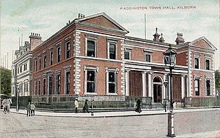
Kilburn is a locality on the boundary of three London Boroughs: Camden, Brent and the City of Westminster. Kilburn High Road railway station lies 3.5 miles (5.6 km) north-west of Charing Cross.

Paddington is an area in the City of Westminster, in central London, England. A medieval parish then a metropolitan borough of the County of London, it was integrated with Westminster and Greater London in 1965. Paddington station, designed by the engineer Isambard Kingdom Brunel opened in 1847. It is also the site of St Mary's Hospital and the former Paddington Green Police Station.

The Westway is a 2.5-mile (4 km) elevated dual carriageway section of the A40 trunk road in West London running from Paddington in the east to North Kensington in the west. It connects the London Inner Ring Road to the West London suburbs.
Paddington was a civil parish and metropolitan borough in London, England. It was an ancient parish in the county of Middlesex, governed by an administrative vestry. The parish was included in the area of responsibility of the Metropolitan Board of Works in 1855 and became part of the County of London in 1889. The parish of Paddington became a metropolitan borough in 1900, following the London Government Act 1899, with the parish vestry replaced by a borough council. In 1965 the borough was abolished and its former area became part of the City of Westminster in Greater London.

Swiss Cottage is an area of Hampstead in the London Borough of Camden, England. It is centred on the junction of Avenue Road and Finchley Road and includes Swiss Cottage tube station. Swiss Cottage lies 3.25 miles (5.23 km) north-northwest of Charing Cross. The area was named after a public house in the centre of it, known as "Ye Olde Swiss Cottage".
West Hampstead is an affluent area in the London Borough of Camden in north-west London. Mainly defined by the railway stations of the same name, it is situated between Childs Hill to the north, Frognal and Hampstead to the north-east, Swiss Cottage to the east, South Hampstead to the south-east and Kilburn to the west and south-west. The neighbourhood is mainly residential with several local amenities including a range of independent shops, supermarkets, restaurants, bars, cafes and bakeries; most of which are concentrated in the northern section of West End Lane and around West End Green. Located in travel zone 2, West Hampstead has excellent transport links, and is served by three stations: West Hampstead on the Jubilee line, West Hampstead Overground station and West Hampstead Thameslink station.

Ossington Street is a quiet one-way street in London, W2, leading from Moscow Road at its north end to the Bayswater Road / Notting Hill Gate at its south end.
Childs Hill is one of two areas at the south end of the London Borough of Barnet along with Cricklewood which straddles three boroughs. It took its name from Richard le Child, who in 1312 held a customary house and "30 acres" of its area. It is a mainly late-19th-century suburban large neighbourhood centred 5 miles (8 km) northwest of Charing Cross bordered by the arterial road Hendon Way in the west and south-west, Dunstan Road in the north, West Heath and Golders Hill Park which form an arm of Hampstead Heath to the east and the borough boundary as to the short south-east border.

Queen's Park is an area in North West London and West London, located partly in the City of Westminster and mostly in the London Borough of Brent. Some of the area within Westminster forms a civil parish, the first to be created in London since the right of communities to establish civil parishes was enacted in 2007. The area is located 4 miles (6.4 km) north-west of Charing Cross, and centred around a 30 acres (12 ha) park, which opened in 1887 and was named in honour of Queen Victoria. The area gives its name to Queens Park Rangers football club.

Westbourne is an area in West London. It has a manorial history spanning many centuries, within a more broadly defined Paddington, before shedding its association in the mid-19th century. It is named after the west bourne, West Bourne, or River Westbourne, a Thames tributary which was encased in 19th-century London in the 1850s. The spring-fed stream and associated manor have led to the place names Westbourne Green, Westbourne Park and more narrowly: Westbourne Gardens, Westbourne Grove, Westbourne Park Road, Westbourne Park tube station, Westbourne Studios and the name of a public house.

Harrow Road is an ancient route in North West London which runs from Paddington in a northwesterly direction towards Harrow. It is also the name given to the immediate surrounding area of Queens Park and Kensal Green, straddling the NW10, W10, W2 and W9 postcodes. With minor deviations in the 19th and 20th centuries, the route remains otherwise unaltered.

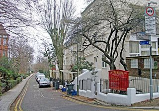
Leinster Gardens is a street in Bayswater, London. It is lined with tall, ornate, mid-Victorian terraced houses, many of which are listed buildings.
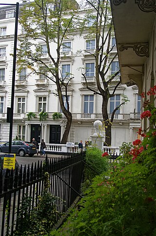
Craven Hill Gardens is a classical, Victorian, residential garden estate which has two small garden squares, the green subset of squares in London. It is in Bayswater, in its Lancaster Gate neighbourhood, south-west of contemporary Paddington of which those districts were once part. It is made up of four rows of residential buildings lining its three streets, and eastern returns, between 160 and 250 metres north of Hyde Park. The western return of this street configuration is partly Leinster Gardens and partly named Leinster Terrace.

Kilburn Priory was a small monastic community of nuns established around 1130–1134 three miles north-west of the City of London, where Watling Street met the stream now known as the Westbourne, but variously known as Cuneburna, Keneburna, Keeleburne, Coldburne, or Caleburn, meaning either the royal or cow's stream. The priory gave its name to the area now known as Kilburn, and the local streets Priory Road, Kilburn Priory, Priory Terrace, and Abbey Road. Kilburn Lane connected the priory to the village of Kensal to the west.
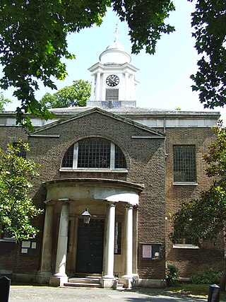
St Mary on Paddington Green is an Anglican church in the Parish of Little Venice, London, and forms part of Paddington Green conservation area. Today it stands at the junction of Edgware Road and Harrow Road, overlooking the East end of Westway and the approaches to Marylebone Flyover, so seen by tens of thousands of motorists daily.
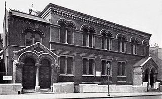
Bayswater Synagogue was an Orthodox Jewish congregation and synagogue located in Chichester Place, Paddington, in the City of Westminster, London, England, in the United Kingdom. The congregation worshipped in the Ashkenazi rite.
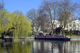
Little Venice is an affluent residential district in West London, England, around the junction of the Paddington Arm of the Grand Union Canal, the Regent's Canal, and the entrance to Paddington Basin. The junction, also known as Little Venice and Browning's Pool, forms a triangular shape basin designed to allow long canal boats to turn around. Many of the buildings in the vicinity are Regency white painted stucco terraced town houses and taller blocks (mansions) in the same style. The area is 2.5 miles (4.0 km) west-north-west of Charing Cross and immediately north-west of Paddington.

Cleveland Square is a private and gated garden square in the predominantly classically conserved Bayswater district of the City of Westminster, north of Central London's Hyde Park. The housing is in tall, tree-shaded rows, stuccoed and with pillared porches, with some discreet infilling of other housing behind.

Hampstead Town hall is a municipal building on Haverstock Hill, Hampstead, London. It is a Grade II listed building.