Golders Green

Last updated

Golders Green
Golders Green clock tower in 2007.jpg
Golders Green clock tower
LondonUnderground GoldersGreenStation.png
Greater London UK location map 2.svg
Red pog.svg
Golders Green
Location within Greater London
Population18,818 (2011 Census.Ward) [1]
OS grid reference TQ248876
London borough
Ceremonial county Greater London
Region
Country England
Sovereign state United Kingdom
Post town LONDON
Postcode district NW11, NW2
Dialling code 020
Police Metropolitan
Fire London
Ambulance London
UK Parliament
London Assembly
List of places
UK
England
London
51°34′24″N0°11′54″W / 51.5734°N 0.1982°W / 51.5734; -0.1982

Golders Green is an area in the London Borough of Barnet in England. A smaller suburban linear settlement, near a farm and public grazing area green of medieval origins, dates to the early 19th century. Its bulk forms a late 19th century and early 20th century suburb with a commercial crossroads. The rest is of later build. It is centred approximately 6 miles (9 km) north west of Charing Cross on the intersection of Golders Green Road and Finchley Road.

Contents

It was founded as a medieval hamlet in the large parish of Hendon, Middlesex. The parish was heavily superseded by Hendon Urban District in 1894 and by the Municipal Borough of Hendon in 1932, abolished in 1965. In the early 20th century, it grew rapidly in response to the opening of a tube station of the London Underground, adjacent to the Golders Green Hippodrome which was home to the BBC Concert Orchestra for many years. The area has a wide variety of housing and a busy main shopping street, Golders Green Road.

It is known for its large Jewish population as well as for being home to the largest Jewish kosher hub (located west of Hoop Lane after the rail bridge) in the United Kingdom, which attracts many Jewish tourists.

History

Map of Middlesex Sheet 011, Ordnance Survey, 1868-1883.jpg
Extract of OS Map of 1868–1883. Click on map to view wider sheet.

The name Golders comes from a family named Godyere who lived in the area, and Green alludes to the manorial common at a cross roads next to which the settlement was built. [2] Golders Green has been a place in the parish and manor of Hendon since around the 13th century. The earliest reference to the name of the adjacent district of "Temple Fortune" is on John Rocque's map of 1754, which also shows what is now Golders Green Road as Groles Green. However the name Temple Fortune reveals a much earlier history. It is likely that the name refers to the Knights of St John, who had land here (c. 1240). Fortune may be derived from a small settlement (tun) on the route from Hampstead to Hendon. Here a lane from Finchley, called Ducksetters Lane (c. 1475), intersected. It is likely that the settlement was originally the Bleccanham estate (c. 10th century). By the end of the 18th century Temple Fortune Farm was established on the northern side of Farm Close.

The building of Finchley Road (c. 1827) replaced Ducksetters Lane as a route to Finchley, and resulted in the development of a small hamlet. Hendon Park Row (c. 1860s) is of this period, and consisted of around thirty small dwellings built by a George Stevens, which were, with two exceptions, demolished around 1956. A small dame school and prayer house run by Anglican deaconesses existed in the 1890s and 1900s, and developed to become St. Barnabas (1915). Along Finchley Road were a number of villas (c. 1830s), joined by the Royal Oak public house (c. 1850s). By the end of the 19th century there were around 300 people living in the area, which included a laundry and a small hospital for children with skin diseases. The principal industry was brick making.
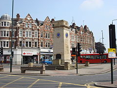
In 1895 Golders Green Jewish Cemetery was established adjacent to Hoop Lane, with the first burial in 1897. Golders Green Crematorium was opened in 1902 (although much of it was built after 1905). A significant moment in Temple Fortune's development into a suburban area occurred in 1907, when transport links were vastly improved by the opening of Golders Green Underground station.

Although the area had been served by horse-drawn omnibuses (since at least the 1880s) and later motor buses (from 1907), the tram line of 1910, connecting Finchley Church End with Golders Green Station, led to the development of the area west of Finchley Road. The establishment of Hampstead Garden Suburb brought major changes to the area east of Finchley Road. Temple Fortune Farm was demolished and along the front of the road the building of the Arcade and Gateway House (c. 1911) established the Hampstead Garden Suburb's retail district.

Both the Golders Green Hippodrome, former home of the BBC Concert Orchestra, and the police station opened in 1913. [3] The now-demolished Orpheum Theatre (1930) was intended to rival the Hippodrome in Golders Green.

Geography

For local elections Golders Green ward covers the north and west of the area; Childs Hill the south to the centre and Garden Suburb, named after Hampstead Garden Suburb: most of the east. Councillors are elected from across 21 wards. Nationally it votes for the MP for seat of Finchley and Golders Green, which encompasses the parts of the NW11 and NW2 postcode districts it contains. [4] The same boundaries are used for the Golders Green, Childs Hill and Garden Suburb wards of the Metropolitan Police Service. [5]

It is about 160 feet (50 m) to 260 feet (80 m) above sea level.

The area is adjacent to the Heath Extensions part of Hampstead Heath.

Demography

Golders Green is often referred to as a Jewish area, and 2021 Census data shows that 49.9% (7,358 of 14,744) [6] [7] of residents identified as Jewish, making it the epicentre of the largest Jewish population in Europe along with its surrounding areas, including Hampstead, Hendon and Finchley within the Borough of Barnet, which is home to 55,000 Jews, the highest percentage Jewish population in any Borough of the United Kingdom. [8]

Ethnically, the Golders Green ward was 64% White (43% British, 21% Other, 1% Irish). Indians, Other Asians and Black Africans made up 5% each, while 6% claimed 'Any other ethnic group'. [8]

Jewish community

There has been a prominent Jewish community in Golders Green since the early 20th century. The Jewish community took root after Hitler's rise to power, with the first German Jewish immigrants forming the Golders Green Beth Hamedrash. Soon after, Galician Jewish immigrants formed other synagogues. With it came the formation of Jewish schools such as Menorah Primary School before the onset of World War II.

There are close to fifty kosher restaurants and eateries under rabbinical supervision in Golders Green, and more than 40 synagogues throughout the area continuing into neighbouring Hendon, as well as 30 Jewish schools (some in outlying areas owing to space restriction), many of them independent.[ citation needed ]

The Jewish community of Hendon and Golders Green is viewed as one by many in the community there, as they share the schooling system as well as rabbinical guidance and synagogue affiliations.

Japanese and East Asian community

Golders Green is home to a growing Japanese and East Asian community [9] with many families living in the district [10] being catered for a notable number of restaurants and shops specialising in Japanese and other East Asian food, such as the Seoul Plaza supermarket.

Economy

The area has restaurants with cuisines from all over the world including Indian, Israeli, Thai, Turkish, Japanese, Chinese, Korean and Italian eateries. These are over a dozen coffee bars; together with a number of niche food stores. The area is home to several leading banks and the high street is well-populated with high-quality amenities.[ according to whom? ]

Transport

Golders Green station is a London Underground tube station on the Northern line in zone 3. It is the first surface station on the Edgware branch when heading north. On the station's forecourt is Golders Green bus station. This is a major hub for London Buses in North West London. [11] National Express coaches also stop at the bus station before/after central London.

Many bus routes pass through Golders Green, including the 210 to Finsbury Park, the 139 to Waterloo, the 13 to Victoria and the 102 to Edmonton Green, and from Golders Green station the 240 to Edgware, the 183 to Pinner and the 245 to Alperton begin their routes.

Education

There are six state aided primary schools in Golders Green; these include: Brookland infant & junior, Garden Suburb infant & junior, Menorah primary school and Wessex Gardens. [12]

The King Alfred School is located on North End Road and Henrietta Barnett School is located in nearby Hampstead Garden Suburb.

Places of worship

Churches

Golders Green Parish Church (Church of England) St Albans, Golders Green-2.jpg
Golders Green Parish Church (Church of England)
Golders Green Synagogue Golders Green Synagogoue 2016.jpg
Golders Green Synagogue

The Anglican parish church of St. Alban the Martyr in North End Road was designed by Sir Giles Gilbert Scott, and in 1933 replaced the original eponymous church, on the site, which is now the parish hall. The latter was built in 1910 and made a parish church in 1922. [13]

St. Edward the Confessor, a Roman Catholic church, was built in 1915 and consecrated in 1931. [14] A Carmelite monastery was established in Bridge Lane in 1908 [15] and sold in 2007. [16]

There is a Greek Orthodox cathedral on Golders Green Road, [17] and a Coptic Orthodox church, [18] both having been Anglican churches for most of the 20th century. The Greek Orthodox church was built in 1914.

The Golders Green Unitarian Church, built in 1925 on Hoop Lane, is Grade II listed; Historic England singles out for mention a "notable temera mural by Ivon Hitchens", among other works. The congregation seceded from Rosslyn Hill Unitarian Chapel (Hampstead) in 1903 but took a generation to build its own place of worship. [19] St Ninian's Presbyterian Church on Helenslea Avenue was built in 1911 by T. P. Figgis, noted for designing stations on the Northern line. The congregation merged with Golders Green Methodist Church (now Trinity Church, Hodford Road) in 1979. The building found new life as a Hindu temple, but was decommissioned in 2013. [20]

Synagogues

There are several synagogues in the area. The first, Golders Green United Synagogue (Dunstan Road), started in 1915 and its current building in Dunstan Road opened in 1922. [21] [22] The Golders Green Beth Hamedrash opened in Golders Green in 1934, moving to the Riding in 1956. The Sassover Beis Hamedrash Helenslea Avenue moved to Golders Green from the East End in 1939 as well as the Beis Yissochor Dov (Hager's) currently in Highfield Avenue and the Hendon Adass on Brent Street.[ citation needed ]

The Beth Shmuel Synagogue in 1942 in Oakfields Road and relocated at 169–171 Golders Green Road in 1945 [23] and is one of the most prominent synagogues in North West London, with Grand Rabbi Elchonon Halpern its longest serving Rabbi for 72 years up until his passing in 2015. In about 1960 the Eastern Jewish Community established the Ohel David Eastern Synagogue at the Lincoln Institute, the former site of the Golders Green Beth Hamedrash. [24] The Machzike Hadath Synagogue moved to Golders Green in the 1970s, opening its present building in 1983. [25]

Other religious buildings

The former Golders Green Hippodrome theatre became an El Shaddai International Christian Centre in 2007 and then an Islamic centre in 2017, and now is a Hillsong Church. [26]

Community facilities

Water Garden in Golders Hill Park Water Garden in Golders Hill Park.jpg
Water Garden in Golders Hill Park

Golders Hill Park, adjoining the West Heath of Hampstead Heath, is a formal park, which includes a small (free) zoo, a walled horticultural garden, pinetum, duckponds, a water garden and a very popular café. During the summer, children's activities are organised and there is often live music on the bandstand. Close to the park, also adjoining the West Heath is the Hill, a formal garden with an extensive and imposing pergola.

Nearby Golders Green Crematorium has an extensive garden with features such as a special children's section and a pond, in keeping with the distinct Italianate air.

The area is the setting of the humorous short story "The Ghoul of Golders Green" (May Fair, 1925) by Michael Arlen.

In his 1944 poem "Death Wish", Spike Milligan expresses his wishes to be buried anywhere except Golders Green Crematorium:

Bury me anywhere,
Somewhere near a tree
Some place where a horse will graze
and gallop over me.

Bury me
Somewhere near a stream,
When she floods her banks
I'll give her thanks
For reaching out to me
In my childhood scene;

But please –
don't burn me
In Golders Green.

In his 1946 book "The Great Divorce," C.S. Lewis has a character from Golders Green. Sarah Smith and her husband are the last characters to enter the novel. She appears with great pomp and circumstance, arrayed in splendor and arriving behind a procession complete with music. She is beautiful and one of the "great ones" in heaven, but on earth had led an anonymous life in Golders Green. [27]

In his travelogue parody "Balham, Gateway to the South", recorded on The Best of Sellers (1958), Peter Sellers parodies John William Burgon's well known description of Petra – "A rose-red city half as old as time" – as "A rose-red city half as gold as green [Golders Green]".

George Harrison recorded an unreleased track called "Going Down to Golders Green". This came about because he would visit members of the pop group Badfinger, who lived at 7 Park Avenue, off North End Road, situated on the borders of Golders Hill Park.

The first posthumous (1997) album release of the music of Pete Ham of the pop group Badfinger was titled 7 Park Avenue , named after the address of Badfinger's band residence in Golders Green. A second posthumous (1999) album release was titled Golders Green .

Places of interest

Notable people

Notes and references

  1. "Barnet Ward population 2011". Neighbourhood Statistics. Office for National Statistics. Retrieved 19 October 2016.
  2. Weinreb, Ben (2008). The London Encyclopaedia (3rd ed.). Macmillan. pp. 328–329. ISBN   978-1-4050-4924-5.
  3. "The UK's best military driving gifts". wanadoo-members.co.uk. Archived from the original on 10 November 2005.
  4. "Finchley and Golders Green BC" (PDF). Boundary Commission for England. 2012. Archived (PDF) from the original on 29 October 2012. Retrieved 29 January 2013.
  5. "Finchley and Golders Green BC". Mayor's Office for Policing and Crime 2014. 2014. Retrieved 29 January 2013.
  6. "Golders Green (Ward, United Kingdom) - Population Statistics, Charts, Map and Location". www.citypopulation.de. Retrieved 24 October 2023.
  7. School, Park East Day (12 February 2019). "Golders Green: A Jewish Epicenter in North London". Rabbi Arthur Schneier Park East Day School. Retrieved 24 October 2023.
  8. 1 2 "Golders Green South: Religion".
  9. "Golders Green – Hidden London". Hidden-london.com. Retrieved 26 October 2017.
  10. Kosher in the country, The Economist 1 June 2006 accessed 14 August 2007
  11. "Buses from Golders Green" (PDF). Transport for London. July 2009. Archived (PDF) from the original on 20 May 2009. Retrieved 9 October 2009.
  12. "Barnet Online – Find a Primary or Nursery School". Archived from the original on 10 February 2012. Retrieved 19 February 2012.
  13. AIM25 Retrieved 29 November 2013
  14. "Roman Catholic Church of St Edward the Confessor". rcdow.org.uk.
  15. "Golders Green, London – Carmelite Nuns". carmelite.org.uk.
  16. Kevin Bradford Property developers do not rule out demolishing Carmelite monastery, in Golders Green, after winning a High Court ruling against Barnet Council 26 November 2009 Hendon & Finchley Times Retrieved 1 May 2012
  17. The Greek Orthodox Cathedral of the Holy Cross & St. Michael Retrieved 1 May 2012
  18. St. Mary & Archangel Michael Coptic Orthodox Church Golders Green, U.K. Retrieved 1 May 2012
  19. Historic England. "UNITARIAN CHAPEL, Barnet (1390934)". National Heritage List for England . Retrieved 28 September 2018.
  20. Shree Swaminarayan Temple London Retrieved 29 November 2013
  21. "Golders Green Synagogue".
  22. "Golders Green Synagogue: The First 100 Years". Helen Fry.
  23. "Hendon: Judaism". british-history.ac.uk.
  24. Jewish Communities & Records 14 December 2011 Retrieved 1 May 2012
  25. Jewish Communities & Records 12 December 2011 Retrieved 1 May 2012
  26. "Megachurch buys Golders Green Hippodrome after mosque plan blocked". TheGuardian.com . 21 October 2021.
  27. Lewis, C.S. (1946). The Great Divorce. Great Britain: HarperOne. pp. 117–118. ISBN   978-0-06-065295-1.
  28. "Dannie Abse - obituary" . The Daily Telegraph. 2014. Archived from the original on 12 January 2022.
  29. גאב"ד ראדמושילא: הגאון רבי אלחנן הלפרין זצ"ל. Kikar HaShabbat (in Hebrew). 18 February 2015. Retrieved 26 January 2022.
  30. Hunnewell, Interviewed by Susannah (2008). "The Art of Fiction No. 196". Vol. Spring 2008, no. 184.{{cite magazine}}: Cite magazine requires |magazine= (help)
  31. McIntyre, Michael (2011). Life and laughing (Large print ed.). Bath: Paragon. ISBN   978-1-4458-5618-6.
  32. Hayward, Anthony (7 October 2010). "Louis Marks obituary". The Guardian. Retrieved 19 April 2021.
  33. Oldfield, Sybil (January 2008). "Simon, Dame Kathleen Rochard, Viscountess Simon" . Oxford Dictionary of National Biography (online ed.). Oxford University Press. doi:10.1093/ref:odnb/66994 . Retrieved 4 January 2013.(Subscription or UK public library membership required.)(subscription required)

Related Research Articles

<span class="mw-page-title-main">Finchley</span> District of London, England

Finchley is a large district of north London, England, in the London Borough of Barnet. Finchley is on high ground, 11 km (6.8 mi) north of Charing Cross.

<span class="mw-page-title-main">Hendon</span> Area of Greater London

Hendon is an urban area in the Borough of Barnet, northwest London 7 miles (11 km) northwest of Charing Cross. Hendon was an ancient manor and parish in the county of Middlesex and a former borough, the Municipal Borough of Hendon; it has been part of Greater London since 1965. Hendon falls almost entirely within the NW4 postcode, while the West Hendon part falls in NW9. Colindale to the northwest was once considered part of Hendon but is today separated by the M1 motorway.

<span class="mw-page-title-main">Mill Hill</span> Human settlement in England

Mill Hill is a suburb in the London Borough of Barnet, England. It is situated around 10 miles (16 km) northwest of Charing Cross. It was in the historic county of Middlesex until 1965, when it became part of Greater London. Its population was 18,451 in 2011.

<span class="mw-page-title-main">Muswell Hill</span> Suburb in north London, England

Muswell Hill is a suburban district of the London Borough of Haringey, north London. The hill, which reaches over 100 m (330 ft) above sea level, is situated 5.5 miles (8.9 km) north of Charing Cross.

<span class="mw-page-title-main">London Borough of Barnet</span> Borough in the United Kingdom

The London Borough of Barnet is a local authority area on the northern outskirts of London. The borough was formed in 1965 from parts of the ceremonial counties of Middlesex and Hertfordshire. It is the second largest London borough by population with 389,344 inhabitants as of 2021, also making it the 17th largest district in England. The borough covers an area of 86.74 square kilometres (33 sq mi), the fourth highest of the 32 London boroughs, and has a population density of 45.8 people per hectare, which ranks it 25th.

<span class="mw-page-title-main">East Finchley</span> Human settlement in England

East Finchley is an area in North London, immediately north of Hampstead Heath. Like neighbouring Muswell Hill, it straddles the London Boroughs of Barnet and Haringey, with most of East Finchley falling into the London Borough of Barnet. It has the greenest high road in London.

<span class="mw-page-title-main">North Finchley</span> Human settlement in England

North Finchley is a suburb of London in the London Borough of Barnet, situated 7 miles (11 km) north-west of Charing Cross.

West Hampstead is an area in the London Borough of Camden in north-west London. Mainly defined by the railway stations of the same name, it is situated between Childs Hill to the north, Frognal and Hampstead to the north-east, Swiss Cottage to the east, South Hampstead to the south-east, Kilburn to the west and south-west, and Cricklewood to the north-west. The area is mainly residential with several small shops, restaurants, cafes, bakeries concentrated on the northern section of West End Lane and around West End Green. It is served by three stations: West Hampstead on the Jubilee line, West Hampstead Overground station and West Hampstead Thameslink station. It is part of the Kilburn postal district (NW6).

<span class="mw-page-title-main">Hampstead Garden Suburb</span> Human settlement in England

Hampstead Garden Suburb is an elevated suburb of London, north of Hampstead, west of Highgate and east of Golders Green. It is known for its intellectual, liberal, artistic, musical and literary associations. It is an example of early twentieth-century domestic architecture and town planning in the London Borough of Barnet, northwest London.

<span class="mw-page-title-main">Finchley Road</span> Dual carriageway in North London

Finchley Road is a designated 4.5-mile (7-kilometre) arterial road in north-west London, England. The Finchley Road starts in St John's Wood near central London as part of the A41; its southern half is a major dual carriageway with high traffic levels often frequented by lorries and long-distance coaches as it connects central London, via the A41 Hendon Way, to the M1 motorway at Brent Cross and other roads at that interchange.

<span class="mw-page-title-main">Childs Hill</span> Human settlement in England

Childs Hill is one of two areas at the south end of the London Borough of Barnet along with Cricklewood which straddles three boroughs. It took its name from Richard le Child, who in 1312 held a customary house and "30 acres" of its area. It is a mainly late-19th-century suburban large neighbourhood centred 5 miles (8 km) northwest of Charing Cross bordered by the arterial road Hendon Way in the west and south-west, Dunstan Road in the north, West Heath and Golders Hill Park which form an arm of Hampstead Heath to the east and the borough boundary as to the short south-east border.

<span class="mw-page-title-main">Municipal Borough of Hendon</span> Former local authority in Middlesex, England

Hendon was an ancient civil parish of around 8,250 acres (33 km2) which included Mill Hill on the border of Hertfordshire, as well as Golders Green and Childs Hill on the border of what became the County of London. In 1894 it was created an urban district of Middlesex and in 1932 it became a municipal borough. The municipal borough was abolished in 1965 and the area became part of the London Borough of Barnet.

<span class="mw-page-title-main">Temple Fortune</span> Human settlement in England

Temple Fortune is a place in the London Borough of Barnet to the north of Golders Green. It is principally a shopping district used by residents of the Hampstead Garden Suburb. Between here and Golders Green, at Hoop Lane are two cemeteries – Golders Green Jewish Cemetery and Golders Green Crematorium. Religious buildings include the Catholic Church of St Edward the Confessor, St. Mary & Archangel Michael Coptic Orthodox Church, and North Western Reform Synagogue.

<span class="mw-page-title-main">Finchley and Golders Green (UK Parliament constituency)</span> Parliamentary constituency in the United Kingdom, 1997 onwards

Finchley and Golders Green is a constituency created in 1997 represented in the House of Commons of the UK Parliament. The current MP is Mike Freer of the Conservative Party, who has held the seat since 2010.

<span class="mw-page-title-main">Church End, Finchley</span> Human settlement in England

Church End is a locality within Finchley in the London Borough of Barnet in London, England. Aside from its church it centres on Finchley Central Underground station. Church End is an old village, now a suburban development, centred 7 miles (11 km) north-northwest of Charing Cross.

The London Borough of Barnet, located on the northern periphery of London and having much of the area within its boundaries in the Metropolitan Green Belt, has many parks and open spaces. In addition there are large areas taken over by cemeteries and golf courses, and part of Hampstead Heath.

<span class="mw-page-title-main">Dollis Valley Greenwalk</span> Ten-mile-long footpath in North London

The Dollis Valley Greenwalk is a footpath route in the London Borough of Barnet in London, England, between Moat Mount Nature Reserve in Mill Hill and Hampstead Heath. The route is designed to act as a link between the Capital Ring and the London Loop, and between the many green spaces and wildlife corridors along the way. It is approximately 10 miles (16 km) long. It mainly follows the Dollis Brook and is one of the many parks and open spaces in Barnet.

<span class="mw-page-title-main">Big Wood and Little Wood</span> Small forested areas in London, England

Big Wood and Little Wood are two patches of woodland in Hampstead Garden Suburb in the London Borough of Barnet. They are a Site of Borough Importance for Nature Conservation, Grade 1, and a Local Nature Reserve. Big Wood is 7.3 hectares and Little Wood is 1.2 hectares.