Finchley Central tube station

Last updated

Finchley Central Underground no-text.svg
Finchley Central station.jpg
Greater London UK location map 2.svg
Red pog.svg
Finchley Central
Location of Finchley Central in Greater London
Location Finchley
Local authority London Borough of Barnet
Managed by London Underground
Number of platforms3
AccessibleYes [1]
Fare zone 4
London Underground annual entry and exit
2017Increase2.svg 7.20 million [2]
2018Decrease2.svg 5.27 million [3]
2019Increase2.svg 8.49 million [4]
2020Decrease2.svg 3.72 million [5]
2021Decrease2.svg 3.52 million [6]
Railway companies
Original company Edgware, Highgate and London Railway
Pre-grouping Great Northern Railway
Post-grouping London and North Eastern Railway
Key dates
22 August 1867Opened (GNR)
1 February 1872Branch line opened (GNR)
11 September 1939Closed (to Edgware)
14 April 1940Started (Northern line)
2 March 1941Ended (LNER)
18 May 1941Started (to Mill Hill East)
1 October 1962Goods yard closed (BR)
Other information
External links
WGS84 51°36′04″N0°11′33″W / 51.6011°N 0.1924°W / 51.6011; -0.1924 Coordinates: 51°36′04″N0°11′33″W / 51.6011°N 0.1924°W / 51.6011; -0.1924
Underground sign at Westminster.jpg  London transportportal

Finchley Central is a London Underground station in the Church End area of Finchley, north London. The station is located on the High Barnet branch of the Northern line, between West Finchley and East Finchley stations; it is the junction for the short branch to Mill Hill East. The station is around 7 miles north-northwest of Charing Cross and is in Travelcard Zone 4.

Contents

The station was opened on 22 August 1867 as part of the Great Northern Railway's line between Finsbury Park and Edgware stations. As part of London Underground's Northern Heights plan, Northern line trains started serving the station in 1940 and main line passenger services ended in 1941.

History

Original station

Finchley Central station before the construction of the branch to High Barnet on an Ordnance Survey map Finchley Central station on Ordnance Survey map, 1873.png
Finchley Central station before the construction of the branch to High Barnet on an Ordnance Survey map

Finchley Central station was built by the Edgware, Highgate and London Railway (EH&LR) on its line from Finsbury Park to Edgware. As construction of the line was nearing completion and before it opened it was purchased in July 1867 by the larger Great Northern Railway (GNR), whose main line from King's Cross ran through Finsbury Park on its way to Potters Bar and the north. [7]

The station, originally named Finchley and Hendon, opened along with the railway to Edgware on 22 August 1867 in what was then rural Middlesex. [8] [9] It was 7.05 miles (11.35 km) north-northwest of Charing Cross as the crow flies, and 7 miles 29 chains (11.8 km) from the GNR terminus at King's Cross. [10] [11] [n 1] A branch line from Finchley Central to High Barnet was constructed by the GNR and opened on 1 April 1872. [9] After the 1921 Railways Act created the Big Four railway companies, the GNR became part of the London & North Eastern Railway (LNER) in 1923. [12] The station was renamed by the GNR twice: to Finchley on 1 February 1872 and Finchley (Church End) on 1 February 1894. It was given its current name on 1 April 1940. [8] [13]

At the start of the 1930s the station had around 54 trains daily from High Barnet running to Finsbury Park and then either King's Cross, Moorgate or Broad Street. Trains between Finchley Central and Edgware typically operated as a shuttle, although some trains ran through to the terminals. [14] [n 2]

Northern Heights plan

In 1935, the London Passenger Transport Board (LPTB) announced a proposal, which became known as the Northern Heights plan, to take over the LNER lines from Finsbury Park to Edgware, High Barnet and Alexandra Palace, and link them to the Northern line with new tunnels from the Northern line's terminus at Archway to East Finchley and to the Northern City line with a new surface connection between Drayton Park and Finsbury Park. [n 3] The line from Finchley Central to Edgware closed for electrification and reconstruction on 11 September 1939. [16] [n 4]

The station was first served by electric Northern line trains on 14 April 1940 when the service was extended from East Finchley to High Barnet. [18] After a period where the station was serviced by both operators, LNER steam services were ended on 2 March 1941. [19] Following the outbreak of the Second World War in September 1939, completion of the electrification works on the line to Edgware was slowed and was completed only as far as Mill Hill East. Northern line services to Mill Hill East began on 18 May 1941 to serve the nearby Inglis Barracks. [19]

Postwar

New line from Finchley Central to Clapham Junction proposed in 1946 Extract from Report to the Minister of War Transport 21 January 1946 Map 2 - Route 12B.jpg
New line from Finchley Central to Clapham Junction proposed in 1946

After the war, the plans to complete the Northern Heights works were reviewed but were not restarted. Maintenance works and reconstruction of war damage on the existing network had the greatest demand for LPTB funds. Funds for new works were severely limited and priority was given to the completion of the western and eastern extensions of the Central line to West Ruislip, Epping and Hainault. [20]

A government-commissioned review of rail transport in the London area produced a report in 1946 that proposed many new lines. It anticipated that completion of the Northern Heights works would put pressure on the Northern line's capacity and it proposed that a relief line should be considered for one or other of the two branches. One of these, designated Route 12B, was proposed to run as a tube line in tunnel from Finchley Central to Clapham Junction via Golders Green, St John's Wood, Baker Street, Knightsbridge and Sloane Square. [21]

Despite being shown as under construction on underground maps as late as 1950, [n 5] work never restarted on the unimplemented parts of the Northern Heights plan. [26] [n 6] The proposal for Route 12B was also not developed by the LPTB or its successor organisations. [n 7]

Before the war, Charles Holden and Reginald Uren designed replacement station buildings to be built on both sides of the road bridge at the north end of the station. The curtailment of the Northern Heights Plan means that the rebuilding work was not implemented and the station still retains much of its original Victorian architectural character today. [29] As one of two EH&LR stations retaining its original buildings (the other is Mill Hill East), it is one of the oldest parts of the Underground system, pre-dating the first tunnelled section of the Northern line (the City & South London Railway) by more than twenty years. [n 8]

British Railways (the successor to the LNER) continued to operate goods trains from Finsbury Park to the station's goods yard until 1 October 1962, when it was closed. [30] [n 9]

The station today

Finchley Central stn look north.JPG
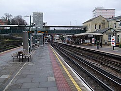
Finchley Central station looking northwest from the island platform
Finchley Central tube station MMB 05 1995 Stock.jpg
Junction north of station: ahead towards Mill Hill East, right towards West Finchley

The station has two entrances. The main one, in the original station building, is on the north side of the tracks in Chaville Way, a short access road from the junction of Ballards Lane, Regents Park Road and Nether Street. The second entrance is to the south of the tracks in Station Road.

The station is in a cutting and the two entrances are joined by a footbridge over the tracks from which stairs and lifts connect to the platforms. The station is accessible for disabled passengers travelling in both directions. [1]

The station has three platforms. Platforms 1 and 2, which share an island platform, are for northbound trains: platform 1 is used mainly by trains terminating at Finchley Central (and trains reverse using a reversing siding north of the station) or going to Mill Hill East; platform 2 is mainly used by trains going to High Barnet. Platform 3, a side platform, is for southbound trains. [32] All platforms have canopies at their northern ends. The large station car park on the north side of the tracks, with access from Chaville Way, occupies the site of the former goods yard.

Services and connections

The station is in Travelcard Zone 4, between West Finchley and East Finchley on the Northern line. [33] Train frequencies vary throughout the day, but generally operate every 3–7 minutes between 05:44 and 01:05 northbound to High Barnet and 05:31 and 01:15 southbound to Kennington (via Charing Cross) or Morden (via Bank). [34] [35] Trains to Mill Hill East operate between 05:16 and 01:06 (except for peak hours and after 23.00 all trains operate as a shuttle between Finchley Central and Mill Hill East). [36] [n 10]

London Bus routes 13, 125, 143, 326, 382 and 460, night route N20, and school routes 626 and 683 serve the station. [37]

Cultural references

Plaque commemorating Harry Beck Beck Plaque.jpg
Plaque commemorating Harry Beck

The station features in the Finchley Central mind game, which in turn became the basis for the game Mornington Crescent in the BBC Radio 4 series I'm Sorry I Haven't a Clue . [38]

The New Vaudeville Band's song "Finchley Central" reached No. 11 in the UK singles charts in 1967. [39] [n 11]

Harry Beck, designer of the original Tube map lived nearby and used the station in the 1930s. There is a commemorative plaque on Platform 3, together with a facsimile enamel panel of Beck's iconic 1933 design. [41]

Notes and references

Notes

  1. Railways in the United Kingdom are, for historical reasons, measured in miles and chains. There are 80 chains to the mile.
  2. Trains to Moorgate ran to King's Cross York Road then used the City Widened Lines. Trains to Broad Street ran via the Canonbury curve and the North London Railway.
  3. In 1938, services through Finchley Central station were planned to run between Bushey Heath and Kennington (via Charing Cross), High Barnet and Kennington (via Charing Cross) and High Barnet and Moorgate (via Finsbury Park). [15]
  4. At Edgware, the LNER's station was to be closed with the end of the line diverted into the Northern line's own Edgware station, with an extension from there taking the line to Bushey Heath. [17]
  5. Shown as "under construction", the Northern Heights extensions appeared for the first time on Underground poster maps in 1937 and pocket maps in 1938. [22] [23] After the opening of the line to Mill Hill East, the uncompleted remainder of the works were removed from the map between 1943 and 1945. [23] The Mill Hill East to Edgware and Edgware to Bushey Heath sections appeared on the map again from 1946 to 1949 and the Finsbury Park to Alexandra Palace section appeared from 1946 to 1950. [24] [25]
  6. The section of the extension between Brockley Hill and Bushey Heath was cancelled in October 1950, [27] leaving the section between Edgware and Brockley Hill and the conversion of the line from Mill Hill East to Edgware to be decided. The announcement of its cancellation was finally made in February 1954. [28]
  7. Of the twelve proposed routes, only Route 8, "A South to North Link - East Croydon to Finsbury Park" was developed, eventually becoming the Victoria line.
  8. The City & South London Railway opened in 1890 between King William Street in the City of London and Stockwell in Lambeth. [18]
  9. Goods services continued on the Edgware branch until 1964. [31]
  10. Northern line trains consist of 1995 stock EMUs; calling at all stations.
  11. The song appeared on an album of the same name. The sleeves of both featured artwork incorporating part of the London Underground map. [40] The singer recounts travelling from Golders Green to Finchley Central on the Northern line and waiting on the platform to meet a woman who does not arrive.

Related Research Articles

<span class="mw-page-title-main">Northern line</span> London Underground line

The Northern line is a London Underground line that runs from North London to South London. It is printed in black on the Tube map. The Northern line is unique on the Underground network in having two different routes through central London, two southern branches and two northern branches. Despite its name, it does not serve the northernmost stations on the Underground, though it does serve the southernmost station at Morden, the terminus of one of the two southern branches.

<span class="mw-page-title-main">Finsbury Park station</span> London Underground and railway station

Finsbury Park is an intermodal interchange station in north London. It serves a number of National Rail, London Underground and bus services. The station is the third busiest Underground station outside Zone 1, with over 33 million passengers using the station in 2019.

<span class="mw-page-title-main">East Finchley tube station</span> London Underground station

East Finchley is a London Underground station in East Finchley in the London Borough of Barnet, north London. The station is on the High Barnet branch of the Northern line, between Finchley Central and Highgate stations, and is in Travelcard Zone 3.

<span class="mw-page-title-main">Highgate tube station</span> London Underground and former railway station

Highgate is a London Underground station and former railway station in Archway Road, in the London Borough of Haringey in north London. The station takes its name from nearby Highgate Village. It is on the High Barnet branch of the Northern line, between East Finchley and Archway stations, and is in Travelcard Zone 3.

<span class="mw-page-title-main">High Barnet tube station</span> London Underground and former railway station

High Barnet is a London Underground station, and former railway station, located in Chipping Barnet, North London. The station is the northern terminus of the High Barnet branch of the Northern line and is in Travelcard Zone 5. It is situated 10.2 miles (16.4 km) north north-west of Charing Cross. The next station south is Totteridge & Whetstone.

<span class="mw-page-title-main">Edgware tube station</span> London Underground station

Edgware Station is a London Underground station in Edgware, in the London Borough of Barnet, in North London. The station is the northern terminus of the Edgware branch of the Northern line and the next station to the south is Burnt Oak. Edgware is in Travelcard Zone 5.

<span class="mw-page-title-main">Mill Hill East tube station</span> London Underground station

Mill Hill East is a London Underground station in Mill Hill in the London Borough of Barnet, north London. The station is the terminus and only station of a single-track branch of the Northern line from Finchley Central station and is in Travelcard Zone 4. It is the least used station on the Northern line with 0.76 million passengers in 2021.

<span class="mw-page-title-main">Totteridge & Whetstone tube station</span> London Underground station

Totteridge & Whetstone is a London Underground station in Whetstone in the London Borough of Barnet, North London. The station is the penultimate one on the High Barnet branch of the Northern line, between High Barnet and Woodside Park stations, in Travelcard Zone 4. It was first built in 1872.

<span class="mw-page-title-main">West Finchley tube station</span> London Underground station

West Finchley is a London Underground station in the Finchley area of the London Borough of Barnet. The station is on the High Barnet branch of the Northern line between Woodside Park and Finchley Central stations and is in Travelcard Zone 4.

<span class="mw-page-title-main">Woodside Park tube station</span> London Underground station

Woodside Park is a London Underground station in Woodside Park, north London.

<span class="mw-page-title-main">Edgware, Highgate and London Railway</span> Former railway in North London

The Edgware, Highgate and London Railway was a railway in North London. The railway was a precursor of parts of London Underground's Northern line and was, in the 1930s the core of an ambitious expansion plan for that line which was thwarted by the Second World War. Parts of the line were closed in the 1950s and have since been removed.

<span class="mw-page-title-main">Muswell Hill railway station</span> Former railway station in England

Muswell Hill railway station was in Muswell Hill in North London, just north of the junction of Muswell Hill and Muswell Hill Place. Nothing remains of the station and Muswell Hill Primary School now occupies its former site. In the 1930s, plans were made to electrify the line and transfer the mainline service to London Underground's Northern line, but these were abandoned after the Second World War. The station closed for passengers in 1954 and goods in 1956.

<span class="mw-page-title-main">Cranley Gardens railway station</span> Former railway station in London

Cranley Gardens railway station was a station in the Muswell Hill area of north London. It was located between Highgate and Muswell Hill stations, at the junction of Muswell Hill Road and Cranley Gardens. Nothing remains of the station today and its site is now occupied by housing and a school. In the 1930s, plans were made to electrify the line and transfer the mainline service to London Underground's Northern line, but these were abandoned after the Second World War. The station closed for passengers in 1954 and for goods in 1957.

<span class="mw-page-title-main">Stroud Green railway station</span> Former railway station in England

Stroud Green railway station is a former station in the Stroud Green area of north London. It was located between Finsbury Park station and Crouch End station on a bridge over Stapleton Hall Road. The station had platforms cantilevered from the bridge structure and a wooden station building at ground level under and on either side of the bridge, with a station master's house to the north of it. The bridge still exists and now carries the Parkland Walk cycle and pedestrian path, whilst the station master's house serves as a community centre.

<span class="mw-page-title-main">Crouch End railway station</span> Abandoned railway station in London

Crouch End railway station is a former station in the Crouch End area of north London. It was located between Stroud Green station and Highgate station on Crouch End Hill just north of its junction with Hornsey Lane. The station building was located on the road bridge over the railway but only small parts remain of the structure today.

<span class="mw-page-title-main">Mill Hill (The Hale) railway station</span> Former railway station in England

Mill Hill railway station was a station in Mill Hill in north London, on the now-removed railway between Mill Hill East station and Edgware railway station. It was located near the junction of Bunns Lane and Lyndhurst Avenue.

<span class="mw-page-title-main">Edgware railway station</span> Former railway station in England

Edgware was a London and North Eastern Railway (LNER) station located on Station Road in Edgware, north London. It was opened in 1867 and was in use as a passenger station until 1939, then as a goods yard until 1964.

Elstree South was a proposed London Underground station in Elstree, Hertfordshire. It was designed by Charles Holden. The planned location of the station was adjacent to the A5183, north of the junction with the A41 and where junction 4 of the M1 motorway was subsequently built.

The New Works Programme of 1935–1940 was the major investment programme delivered by the London Passenger Transport Board (LPTB), commonly known as London Transport, which had been created in 1933 to coordinate underground train, tram, trolleybus and bus services in the capital and the surrounding areas. The programme was to develop many aspects of the public transport services run by the LPTB and the suburban rail services of the Great Western Railway (GWR) and London and North Eastern Railway (LNER). The investment was largely backed by government assistance as well as by the issuing of financial bonds and was estimated to cost £42,286,000 in 1936.

<span class="mw-page-title-main">Dollis Brook Viaduct</span> Railway viaduct in Finchley, London

The Dollis Brook Viaduct, also known as the Dollis Road Viaduct, Dollis Viaduct or Mill Hill Viaduct, is a railway viaduct to the west of Finchley, North London, United Kingdom. It carries the London Underground's Northern line from Mill Hill East station to Finchley Central station. It is the highest point on the London Underground above ground level, reaching nearly 60 feet (18 m). It is located on a branch that was formerly part of the Edgware, Highgate and London Railway.

References

  1. 1 2 "Step free Tube Guide" (PDF). Transport for London . April 2021. Archived (PDF) from the original on 15 May 2021.
  2. "Multi-year station entry-and-exit figures (2007–2017)". London Underground station passenger usage data. Transport for London. January 2018. Archived from the original (XLSX) on 31 July 2018. Retrieved 22 July 2018.
  3. "Station Usage Data" (CSV). Usage Statistics for London Stations, 2018. Transport for London. 21 August 2019. Archived from the original on 22 May 2020. Retrieved 27 April 2020.
  4. "Station Usage Data" (XLSX). Usage Statistics for London Stations, 2019. Transport for London. 23 September 2020. Archived from the original on 9 November 2020. Retrieved 9 November 2020.
  5. "Station Usage Data" (XLSX). Usage Statistics for London Stations, 2020. Transport for London. 16 April 2021. Retrieved 1 January 2022.
  6. "Station Usage Data" (XLSX). Usage Statistics for London Stations, 2021. Transport for London. 12 July 2022. Retrieved 7 September 2022.
  7. Beard 2002, p. 6.
  8. 1 2 Butt 1995, p. 96.
  9. 1 2 "Northern Line - Dates". Clive's Underground Line Guides. 27 January 2015. Archived from the original on 29 September 2015. Retrieved 24 October 2015.
  10. Deaves, Phil. "Engineer's Line References: ECM1 - King's Cross to Shaftholme Junction". Railway Codes. Retrieved 17 November 2015.
  11. Deaves, Phil. "Engineer's Line References: HBB - High Barnet Branch". Railway Codes. Retrieved 17 November 2015.
  12. Wolmar 2005, p. 227.
  13. Harris 2001, p. 28.
  14. Horne 2009, p. 41.
  15. Beard 2002, pp. 58–59.
  16. Beard 2002, p. 92.
  17. Beard 2002, p. 59.
  18. 1 2 Rose 1999.
  19. 1 2 Day & Reed 2010, p. 140.
  20. Bownes, Green & Mullins 2012, p. 173.
  21. Inglis 1946, pp. 17–18.
  22. Beard 2002, pp. 56–57.
  23. 1 2 "London Transport Underground Maps 1938–1945". Archived from the original on 24 September 2015. Retrieved 29 August 2015.
  24. "London Transport Underground Maps 1946–1947". Archived from the original on 24 September 2015. Retrieved 29 August 2015.
  25. "London Transport Underground Maps 1948–1956". Archived from the original on 24 September 2015. Retrieved 29 August 2015.
  26. Day & Reed 2010, p. 152.
  27. Beard 2002, p. 126.
  28. Beard 2002, p. 127.
  29. "Gallery Search". ribapix.com. Royal Institute of British Architects . Retrieved 2 October 2010.
  30. "Underground: The Journal of the London Underground Railway Society" (PDF) (12). December 1962: 7. Retrieved 28 November 2017.{{cite journal}}: Cite journal requires |journal= (help)
  31. "Highgate Station". Disused stations. Retrieved 24 October 2015.
  32. "Finchley Central Underground Station". Transport for London . Retrieved 15 April 2018.
  33. Standard Tube Map (PDF) (Map). Not to scale. Transport for London. November 2022. Archived (PDF) from the original on 7 November 2022. Retrieved 12 November 2022.
  34. "Northern line timetable: From Finchley Central Underground Station to West Finchley Underground Station". Transport for London . Retrieved 30 March 2018.
  35. "Northern line timetable: From Finchley Central Underground Station to East Finchley Underground Station". Transport for London . Retrieved 30 March 2018.
  36. "Northern line timetable: From Finchley Central Underground Station to Mill Hill East Underground Station". Transport for London . Retrieved 30 March 2018.
  37. "Buses from Finchley Central" (PDF). Transport for London. 1 April 2017. Retrieved 29 March 2018.
  38. Partington, Jonathan R. "Paradoxes and Unplayable Games". Archived from the original on 4 March 2016. Retrieved 27 September 2015.
  39. "Finchley Central". Official Charts. Retrieved 8 April 2018.
  40. "The New Vaudeville Band – Finchley Central". Discogs. Retrieved 8 April 2018.
  41. Martin 2012, p. 202.

Bibliography

Listen to this article (6 minutes)
noicon
Sound-icon.svg
This audio file was created from a revision of this article dated 13 December 2007 (2007-12-13), and does not reflect subsequent edits.
Preceding station Underground no-text.svg London Underground Following station
West Finchley
towards High Barnet
Northern line
High Barnet branch
East Finchley
Mill Hill East
Terminus