Edgware tube station

Last updated

Edgware Underground no-text.svg
Edgware Station (2) 01.jpg
Edgware Station
Greater London UK location map 2.svg
Red pog.svg
Edgware
Location of Edgware in Greater London
Location Edgware
Local authority London Borough of Barnet
Managed by London Underground
Number of platforms3
AccessibleYes [1]
Fare zone 5
London Underground annual entry and exit
2018Decrease2.svg 4.91 million [2]
2019Increase2.svg 4.92 million [3]
2020Decrease2.svg 2.82 million [4]
2021Decrease2.svg 2.28 million [5]
2022Increase2.svg 3.93 million [6]
Key dates
18 August 1924Opened (CCE&HR)
Other information
External links
WGS84 51°36′50″N0°16′30″W / 51.614°N 0.275°W / 51.614; -0.275
Underground sign at Westminster.jpg  London transportportal

Edgware is a London Underground station in Edgware, in the London Borough of Barnet, in North London. The station is the northern terminus of the Edgware branch of the Northern line and the next station towards south is Burnt Oak. Edgware is in Travelcard Zone 5.

Contents

Location

The station is in Station Road, Edgware (part of the A5100). This road runs north-east from the High Street (A5), and the station is about 500 metres from the A5 on the right (south-east) side. The building is set back from the road, and there is a circular service road between the building and the road to allow cars to pull in and pick up or set down.

Just to the right of the station, viewed from Station Road, is a road to the bus station and bus garage.

The Broadwalk Centre can be easily accessed from the station, there is a footpath that leads directly to the Broadwalk carpark and commuter carpark.

History

The station was opened on 18 August 1924 as the terminus of the second phase of the Underground Group's extension of the Charing Cross, Euston & Hampstead Railway from Golders Green. It was designed by architect Stanley Heaps. There are three platforms, an island lying east of a single platform (platform 1). A trainshed covers the island platforms (2 and 3).

Despite having already had a railway station since 1867 (Edgware station on the London and North Eastern Railway), Edgware was, in 1924, still very much a village in character. The new Underground station was built on the north edge of the village in open fields and, as intended, the new line stimulated rapid suburban expansion along its length. By the end of the decade, what had formerly been fields was quickly being covered with new housing.

The site of the station is very close to the location intended for the unbuilt Watford and Edgware Railway's (W&ER's) station, which was intended to be built on a branch from the existing single-track LNER branch before the terminus and run through to Watford Junction via Bushey.

New Works Programme

Planned Bushey Heath extension Bushey Heath Extension.png
Planned Bushey Heath extension
Map of Edgware from 1930 showing the Underground station (top) and LNER station (bottom) with its branch line heading east. Extract of 1930 map of Edgware.png
Map of Edgware from 1930 showing the Underground station (top) and LNER station (bottom) with its branch line heading east.

In 1935 London Underground announced its New Works Programme. This had major implications for Edgware Underground station and the Morden-Edgware Line (as the Northern line was then known):

Much of the land for the railway's alignment had originally been bought by the W&ER in the 19th century, but it had not been able to raise the capital to fund the construction and its power's had expired in 1911. The Underground Group had bought the W&ER in 1922. The Underground's scheme modified the W&ER's plan to connect to the LNER branch by starting the extension from the Morden-Edgware Line station instead. The scheme involved the closure of the LNER station 200 metres south of the Underground station and retained the W&ER's connection to the LNER's single track line from where it passed over the Underground's tracks just to the east of the station and into new platforms to be built in the Underground station.

The new link at Edgware and others between LNER and Underground tracks near East Finchley station and at Finsbury Park would have made it theoretically possible to travel south from Edgware to central London via three routes:

Postponement and cancellation

How Edgware might have appeared on the London Underground Map today if the extensions to Bushey Heath and Mill Hill East had been constructed Bushey Heath Extension Mockup.svg
How Edgware might have appeared on the London Underground Map today if the extensions to Bushey Heath and Mill Hill East had been constructed

Works to upgrade the existing LNER lines and construction on the new line to Bushey Heath began in the late 1930s but were halted by the outbreak of the Second World War. Additional platforms were started at Edgware and the LNER station and branch line was closed to passenger traffic in 1939 in preparation for the improvements. On the new extension, some earthworks and tunnelling had been undertaken and some structures had been constructed but no further work was done during the war.

The Metropolitan Green Belt was introduced to limit the outward expansion of London into the surrounding countryside. The area through which the new Bushey Heath extension was routed was designated as green belt meaning that the planned residential developments were prevented and the need for the stations serving them was removed.

Edgware LNER station was never reopened for passengers although freight traffic used the line until the 1960s. The improvements on the branch to Finchley were completed only between Mill Hill East and Finchley Central and only that short section was incorporated into the Northern line (as it had been renamed in the late 1930s). The completion of the plans were formally cancelled in 1950.

Accident

On 27 July 1946, an accident occurred at Edgware when the driver (James Lofting) of a northbound train suffered a heart attack while entering the station. The train did not stop within the area of the platform, and struck the buffers at approximately 5 mph. No passengers were seriously injured, but Lofting died as a result of his heart failure before he could be removed from the wreckage. It appeared from the condition of the controls that Lofting had disabled the deadman's handle while the train was still moving. [7] The circumstances of this accident were similar to those of the Moorgate tube crash of 1975.

Modernisation

During 2008–09, Tube Lines carried out work to modernise the station, including the fitting of lifts to enable step-free platform access, improved CCTV coverage and more help points. [8]

Connections

London Buses routes 32, 79, 107, 113, 142, 186, 204, 221, 240, 251, 288, 292, 303, 340, 384 and night routes N5, N16 and N113 and non-London bus routes 614 [9] and 644 serve the station and bus station.

Services

Preceding station Underground no-text.svg London Underground Following station
Terminus Northern line
Burnt Oak
Abandoned Northern Heights Extension
Brockley Hill
towards Bushey Heath
Northern line
Mill Hill (The Hale)
towards Morden or Kennington

See also

Related Research Articles

<span class="mw-page-title-main">Northern line</span> London Underground line

The Northern line is a London Underground line that runs from North London to South London. It is printed in black on the Tube map. The Northern line is unique on the Underground network in having two different routes through central London, two southern branches and two northern branches. Despite its name, it does not serve the northernmost stations on the Underground, though it does serve the southernmost station at Morden, the terminus of one of the two southern branches.

<span class="mw-page-title-main">Finsbury Park station</span> London Underground and railway station

Finsbury Park is an intermodal interchange station in North London for London Underground, National Rail and London Buses services. The station is the third busiest Underground station outside Zone 1, with over 33 million passengers using the station in 2019.

<span class="mw-page-title-main">Camden Town tube station</span> London Underground station

Camden Town is a London Underground station in Camden Town. It is a major junction for the Northern line, as it is where the Edgware and High Barnet branches merge from the north, and is also where they split to the south into the Bank and Charing Cross branches for the journey through Central London. It is particularly busy with visitors to the Camden markets at weekends, and, until 2019, was exit-only on Sundays to prevent overcrowding.

<span class="mw-page-title-main">East Finchley tube station</span> London Underground station

East Finchley is a London Underground station in East Finchley in the London Borough of Barnet, north London. The station is on the High Barnet branch of the Northern line, between Finchley Central and Highgate stations, and is in Travelcard Zone 3.

<span class="mw-page-title-main">Highgate tube station</span> London Underground and former railway station

Highgate is a London Underground station and former railway station in Archway Road, in the London Borough of Haringey in north London. The station takes its name from nearby Highgate Village. It is on the High Barnet branch of the Northern line, between East Finchley and Archway stations, and is in Travelcard Zone 3.

<span class="mw-page-title-main">High Barnet tube station</span> London Underground and former railway station

High Barnet is a London Underground station, and former railway station, located in Chipping Barnet, North London. The station is the northern terminus of the High Barnet branch of the Northern line and is in Travelcard Zone 5. It is situated 10.2 miles (16.4 km) north north-west of Charing Cross. The next station south is Totteridge & Whetstone.

<span class="mw-page-title-main">Stanmore tube station</span> London Underground station

Stanmore is a London Underground station in Stanmore, north-west London. It is the northern terminus of the Jubilee line and the next station towards south is Canons Park. The station is on the south side of London Road and is in Travelcard Zone 5.

<span class="mw-page-title-main">Archway tube station</span> London Underground station

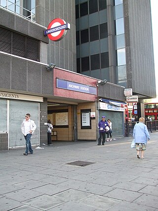
Archway is a London Underground station at the intersection of Holloway Road, Highgate Hill, Junction Road and Archway Road in Archway, north London, directly underneath the Vantage Point building. It is on the High Barnet branch of the Northern line, between Highgate and Tufnell Park stations, in Zones 2 and 3.

<span class="mw-page-title-main">Mill Hill East tube station</span> London Underground station

Mill Hill East is a London Underground station in Mill Hill in the London Borough of Barnet, north London. The station is the terminus and only station of a single-track branch of the Northern line from Finchley Central station and is in Travelcard Zone 4. It is the least used station on the Northern line with 1.41 million passengers in 2022.

<span class="mw-page-title-main">Finchley Central tube station</span> London Underground station

Finchley Central is a London Underground station in the Church End area of Finchley, north London. The station is located on the High Barnet branch of the Northern line, between West Finchley and East Finchley stations; it is the junction for the short branch to Mill Hill East. The station is around 7 miles north-northwest of Charing Cross and is in Travelcard Zone 4.

<span class="mw-page-title-main">Totteridge & Whetstone tube station</span> London Underground station

Totteridge & Whetstone is a London Underground station in Whetstone in the London Borough of Barnet, North London. It is on the High Barnet branch of the Northern line, between High Barnet and Woodside Park stations, in Travelcard Zone 4. It was first built in 1872.

<span class="mw-page-title-main">Woodside Park tube station</span> London Underground station

Woodside Park is a London Underground station in Woodside Park, north London.

<span class="mw-page-title-main">Edgware, Highgate and London Railway</span> Former railway in North London

The Edgware, Highgate and London Railway was a railway in North London, England. The railway was a precursor of parts of London Underground's Northern line and was, in the 1930s, the core of an ambitious expansion plan for that line which was thwarted by the Second World War. Parts of the line were closed in the 1950s and have since been removed.

<span class="mw-page-title-main">Cranley Gardens railway station</span> Former railway station in London

Cranley Gardens railway station was a station in the Muswell Hill area of north London. It was located between Highgate and Muswell Hill stations, at the junction of Muswell Hill Road and Cranley Gardens. Nothing remains of the station today and its site is now occupied by housing and a school. In the 1930s, plans were made to electrify the line and transfer the mainline service to London Underground's Northern line, but these were abandoned after the Second World War. The station closed for passengers in 1954 and for goods in 1957.

<span class="mw-page-title-main">Mill Hill (The Hale) railway station</span> Former railway station in England

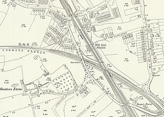
Mill Hill (The Hale) was a station in Mill Hill in north London, on the now-removed railway between Mill Hill East station and Edgware railway station. It was located near the junction of Bunns Lane and Lyndhurst Avenue.

<span class="mw-page-title-main">Edgware railway station</span> Former railway station in England

Edgware was a London and North Eastern Railway (LNER) station located on Station Road in Edgware, north London. It was opened in 1867 and was in use as a passenger station until 1939, then as a goods yard until 1964.

<span class="mw-page-title-main">Brockley Hill tube station</span> Cancelled London Underground station

Brockley Hill was a proposed London Underground station that was going to be built at Brockley Hill in north London as part of the 1935-1940 New Works Programme for the London Passenger Transport Board. This station would have been the first of three to be built as part of a 1930s extension project to extend the Northern Line to Bushey Heath. The next stops being Elstree South and Bushey Heath, both would have been near the Aldenham Works, London Transport's main bus overhaul depot.

Elstree South was a proposed London Underground station in Elstree, Hertfordshire. It was designed by Charles Holden. The planned location of the station was adjacent to the A5183, north of the junction with the A41 and where junction 4 of the M1 motorway was subsequently built.

Bushey Heath was a proposed, but unbuilt, London Underground station in Bushey Heath, Hertfordshire, England. The planned location of the station was at the junction of the A41 and A411 roads.

The New Works Programme of 1935–1940 was the major investment programme delivered by the London Passenger Transport Board (LPTB), commonly known as London Transport, which had been created in 1933 to coordinate underground train, tram, trolleybus and bus services in the capital and the surrounding areas. The programme was to develop many aspects of the public transport services run by the LPTB and the suburban rail services of the Great Western Railway (GWR) and London and North Eastern Railway (LNER). The investment was largely backed by government assistance as well as by the issuing of financial bonds and was estimated to cost £42,286,000 in 1936.

References

  1. "Step free Tube Guide" (PDF). Transport for London . April 2021. Archived (PDF) from the original on 15 May 2021.
  2. "Station Usage Data" (CSV). Usage Statistics for London Stations, 2018. Transport for London. 23 September 2020. Archived from the original on 14 January 2023. Retrieved 11 October 2023.
  3. "Station Usage Data" (XLSX). Usage Statistics for London Stations, 2019. Transport for London. 23 September 2020. Archived from the original on 9 November 2020. Retrieved 9 November 2020.
  4. "Station Usage Data" (XLSX). Usage Statistics for London Stations, 2020. Transport for London. 16 April 2021. Retrieved 1 January 2022.
  5. "Station Usage Data" (XLSX). Usage Statistics for London Stations, 2021. Transport for London. 12 July 2022. Retrieved 7 September 2022.
  6. "Station Usage Data" (XLSX). Usage Statistics for London Stations, 2022. Transport for London. 4 October 2023. Retrieved 10 October 2023.
  7. Mount, Lt Col A H L (17 October 1946). "Report on the Collision at Edgware" (PDF). Ministry of Transport. Retrieved 21 October 2008.{{cite journal}}: Cite journal requires |journal= (help)
  8. "Edgware station going up in the world". Rail Technology Magazine. 23 January 2009. Archived from the original on 15 July 2011. Retrieved 26 January 2009.
  9. Marius, Callum (21 July 2021). "I went on London's fastest bus route and it's like riding a magic carpet". MyLondon. Retrieved 24 July 2021.