Brockley Hill tube station

Last updated

Brockley Hill
Brockley Hill tube station viaduct.jpg
Remains of viaduct built for Brockley Hill station
Greater London UK location map 2.svg
Red pog.svg
Brockley Hill
Location of Brockley Hill in Greater London
LocationBrockley Hill
Local authority Barnet
Grid reference TQ187931
OwnerNever Opened
Number of platforms2
Railway companies
Original company London Underground
Other information
WGS84 51°37′26″N0°17′13″W / 51.624°N 0.287°W / 51.624; -0.287
Underground sign at Westminster.jpg  London transportportal

Brockley Hill was a proposed London Underground station that was going to be built at Brockley Hill in north London as part of the 1935-1940 New Works Programme for the London Passenger Transport Board. This station would have been the first of three to be built as part of a 1930s extension project (known as the "Northern Heights") to extend the Northern Line to Bushey Heath. The next stops being Elstree South and Bushey Heath, both would have been near the Aldenham Works, London Transport's main bus overhaul depot.

Contents

Brockley Hill station was never completed because project funding was withdrawn in December 1939 due to the outbreak of the Second World War. Post-war the project did not restart because the Town and Country Planning Act 1947 had created the Metropolitan Green Belt around London curtailing further urban expansion. Without the planned housing estates to serve the line, the Northern Heights extension project was permanently cancelled. Most of the pre-war brick foundations for Brockley Hill station and its approach viaduct were demolished in the subsequent decade. The station's location is in what is now Edgware Way Grassland close to Edgwarebury Park on the north side of the junction of Edgware Way / Watford Bypass (A41), and Spur Road (A410).

History

Planning and construction

Planned route of the Bushey Heath extension superimposed on a 1934 map showing the rural nature of the area Bushey Heath Extension superimposed on 1934 OS Map.jpg
Planned route of the Bushey Heath extension superimposed on a 1934 map showing the rural nature of the area

The station was the first of three planned by London Passenger Transport Board (LPTB) in 1935 to extend the Northern line from Edgware to Bushey Heath. [1] There was debate about the name for the station, with Edgwarebury, Edgebury, Canons, North Edgware and All Souls all being proposed. [2] [n 1]

The extension was part of the Northern Heights project which was intended to electrify a number of steam-operated London and North Eastern Railway (LNER) branch lines and to incorporate them into the Northern line. Much of the land for the extension came from the purchase in 1922 by the LPTB's precursor, the Underground Electric Railways Company of London, of the unbuilt Watford and Edgware Railway (W&ER). [3] The W&ER had planned an extension of the Edgware, Highgate and London Railway to Watford Junction via Bushey, but it had never raised the capital required and its powers to construct a line had expired in 1911. [3] The specific route to Bushey Heath was approved by parliament in October 1937. [4] The LPTB's principal purpose for the extension to Elstree was to stimulate the development of new residential areas to increase passenger numbers. [5] A secondary purpose was to provide a location suitable for a large new depot that was required to accommodate and maintain the new fleet of 1938 Stock trains to be used across the existing Northern line and the lines taken over from the LNER. [1] [6] [n 2] [n 3]

Brockley Hill station was to be located on a viaduct to the north of the existing junction of Edgware Way and Spur Road. The T-junction was to be reconstructed as a roundabout to incorporate a forecourt for access to a curving range of shops and a continuation of Spur Road heading to the north-east to a new housing development. [10] The station was designed by the LPTB's architectural department in conjunction with the estates department of All Souls College. [11] [n 4] The station platforms were to be on the viaduct and on a bridge over Spur Road and were to be long enough for nine-car trains being planned for the new Northern line service. The ticket hall was to be located under the bridge with stairs up to the platforms and provision for escalators to be installed later. The station was to be provided with a car park for 20–25 cars. [10]

Construction on the Northern Heights project began in the late 1930s but was interrupted by the Second World War. Most of the work to that date had been carried out on LNER branch tracks, but work between Edgware and Bushey Heath had started in June 1939. The route of the line had been cleared and laid out and some earthworks and tunnelling carried out between Edgware and Elstree South. [13] At the site of Brockley Hill station and south of Edgware Way, construction of the piers of the viaduct had begun and three out of 12 arches at Brockley Hill station had been completed by August 1939. [13] Following the outbreak of war in Europe, work on the station and the extension was suspended in September 1939 and was formally terminated in December of the same year as wartime funding restrictions would prevent completion. [14] During the war years, the LPTB-owned land was used for farming vegetables for staff canteens. [15]

Cancellation

The remains of the incomplete viaduct at Brockley Hill, 1963 Ordnance Survey Map Site of Brockley Hill Underground station on 1963 OS Map.jpg
The remains of the incomplete viaduct at Brockley Hill, 1963 Ordnance Survey Map

The sites of the new stations were semi-rural and, as elsewhere, it was intended that the new section would stimulate the construction of housing estates that the stations would serve. After the war, new legislation limited expansion of urban areas into the countryside. This created the Metropolitan Green Belt around London and the area covered the Northern line extension. Without housing estates, the line had no purpose and the plans for the route north of Brockley Hill were cancelled in October 1950. [16]

Some consideration was given to completing the extension as far as Brockley Hill, as it had some housing and the site lay just within the green belt. The line beyond to Bushey Heath would have been completed for access to the depot. Analysis showed the capacity needed without the Bushey Heath extension could be accommodated by developing LNER's former Highgate depot, and the final part of the route was abandoned on 26 November 1953. [17] [n 5]

The viaduct piers south of Edgware Way were demolished in 1959 to make way for new housing. [18] The completed arches of the station viaduct were partially demolished in the 1960s leaving stumps of brickwork in a field and part of the north abutment of the bridge adjacent to Edgware Way. [18] Earthworks north of the station site parallel with the bypass indicate the route towards Elstree South.

Route between Edgware and Brockley Hill

Northern Heights extension route now occupied by housing in Campbell Croft, Edgware.JPG
Campbell Croft
Northern Heights extension route, Shelley Close, Edgware.JPG
Shelley Close
Residential development along the abandoned route between Edgware and Brockley Hill stations

The route for the railway north from Edgware station had been reserved through the W&ER's right of way before Edgware station was built. As Edgware developed as a suburb of London following the opening of the Underground station in 1924, [19] the route was left clear of housing. [20]

The line was to pass under Station Road and Rectory Lane. It would have then run in a cutting north-west, before cutting Purcells Avenue in two, where a footbridge was to be provided to connect the severed ends. [21] North of Purcells Avenue the tracks continued north-west, rising on to a viaduct to cross over Edgware Way on a bridge to meet the viaduct at the southern end of Brockley Hill station. [21] Following the abandonment of the extension, the unused land between Edgware and Brockley Hill was developed for housing with the western end of Heronsgate, Campbell Croft, Shelley Close and the southern section of Sterling Avenue filling the space. [18]

Notes and references

How Brockley Hill station would appear on the London Underground Map if the Northern line extension to Bushey Heath and Mill Hill East had been completed Bushey Heath Extension Mockup.svg
How Brockley Hill station would appear on the London Underground Map if the Northern line extension to Bushey Heath and Mill Hill East had been completed

Notes

  1. A protracted, series of discussions within the LPTB and with other interested parties took place during 1937 and 1938. The original name proposed and used during much of planning stages was "Edgwarebury", linked to the nearby village. This was disliked by LPTB chairman Lord Ashfield because it was three syllables. He proposed a shortening to "Edgebury" though All Souls College, owner of some of the land to be used, disliked this and preferred the name of the village or that of the local landmark Brockley Hill. LPTB managing director Frank Pick suggested "All Souls", but that was considered to be a depressing name by the Commercial Manager, Alec Valentine. "Canons" was considered by the LPTB due to the proximity of Canons Park. If adopted, the Metropolitan line (now Jubilee line) station of that name was to be renamed "Whitchurch". [2]
  2. The Northern line's depot at Golders Green and the Northern City line's depot at Drayton Park were poorly arranged and unsuitable for the accommodation and maintenance of the new trains. [7] The LPTB considered constructing a new depot alongside the LNER's line between Finchley Central and Edgware, but could not negotiate a deal with the local authority for a suitable site in time to enable the depot to be built before the new rolling stock was to be delivered. [8]
  3. The arrangement of the depot at Aldenham located between Elstree South and Bushey Heath was intended to be similar to that between Oakwood and Cockfosters on the recently opened Piccadilly line extension. [9]
  4. At the same time, All Souls College was planning the development of a shopping centre along the existing section of Spur Road. [12]
  5. The public announcement of the cancellation was not made until February 1954. [17]

Related Research Articles

<span class="mw-page-title-main">Northern line</span> London Underground line

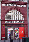
The Northern line is a London Underground line that runs from North London to South London. It is printed in black on the Tube map. The Northern line is unique on the Underground network in having two different routes through central London, two southern branches and two northern branches. Despite its name, it does not serve the northernmost stations on the Underground, though it does serve the southernmost station at Morden, the terminus of one of the two southern branches.

<span class="mw-page-title-main">East Finchley tube station</span> London Underground station

East Finchley is a London Underground station in East Finchley in the London Borough of Barnet, north London. The station is on the High Barnet branch of the Northern line, between Finchley Central and Highgate stations, and is in Travelcard Zone 3.

<span class="mw-page-title-main">Highgate tube station</span> London Underground and former railway station

Highgate is a London Underground station and former railway station in Archway Road, in the London Borough of Haringey in north London. The station takes its name from nearby Highgate Village. It is on the High Barnet branch of the Northern line, between East Finchley and Archway stations, and is in Travelcard Zone 3.

<span class="mw-page-title-main">Stanmore tube station</span> London Underground station

Stanmore is a London Underground station in Stanmore. It is the northern terminus of the Jubilee line and the next station towards south is Canons Park. The station is on the south side of London Road and is in Travelcard Zone 5.

<span class="mw-page-title-main">Bushey</span> Town in Hertfordshire, England

Bushey is a town in the Hertsmere borough of Hertfordshire in the East of England. It had a population of 25,328 in the 2011 census, rising to 28,416 in the 2021 census, an increase of 12.19%. This makes Bushey the second most populated town in Hertsmere. Bushey Heath is a large neighbourhood south east of Bushey on the boundary with the London Borough of Harrow reaching elevations of 165 metres (541 ft) above sea level.

<span class="mw-page-title-main">Edgware tube station</span> London Underground station

Edgware is a London Underground station in Edgware, in the London Borough of Barnet, in North London. The station is the northern terminus of the Edgware branch of the Northern line and the next station towards south is Burnt Oak. Edgware is in Travelcard Zone 5.

<span class="mw-page-title-main">Mill Hill East tube station</span> London Underground station

Mill Hill East is a London Underground station in Mill Hill in the London Borough of Barnet, north London. The station is the terminus and only station of a single-track branch of the Northern line from Finchley Central station and is in Travelcard Zone 4. It is the least used station on the Northern line with 1.41 million passengers in 2022.

<span class="mw-page-title-main">Finchley Central tube station</span> London Underground station

Finchley Central is a London Underground station in the Church End area of Finchley, north London. The station is located on the High Barnet branch of the Northern line, between West Finchley and East Finchley stations; it is the junction for the short branch to Mill Hill East. The station is around 7 miles north-northwest of Charing Cross and is in Travelcard Zone 4.

<span class="mw-page-title-main">Edgware, Highgate and London Railway</span> Former railway in North London

The Edgware, Highgate and London Railway was a railway in North London, England. The railway was a precursor of parts of London Underground's Northern line and was, in the 1930s, the core of an ambitious expansion plan for that line which was thwarted by the Second World War. Parts of the line were closed in the 1950s and have since been removed.

<span class="mw-page-title-main">Muswell Hill railway station</span> Former railway station in England

Muswell Hill railway station was in Muswell Hill in North London, just north of the junction of Muswell Hill and Muswell Hill Place. Nothing remains of the station and Muswell Hill Primary School now occupies its former site. In the 1930s, plans were made to electrify the line and transfer the mainline service to London Underground's Northern line, but these were abandoned after the Second World War. The station closed for passengers in 1954 and goods in 1956.

<span class="mw-page-title-main">Cranley Gardens railway station</span> Former railway station in London

Cranley Gardens railway station was a station in the Muswell Hill area of north London. It was located between Highgate and Muswell Hill stations, at the junction of Muswell Hill Road and Cranley Gardens. Nothing remains of the station today and its site is now occupied by housing and a school. In the 1930s, plans were made to electrify the line and transfer the mainline service to London Underground's Northern line, but these were abandoned after the Second World War. The station closed for passengers in 1954 and for goods in 1957.

<span class="mw-page-title-main">Mill Hill (The Hale) railway station</span> Former railway station in England

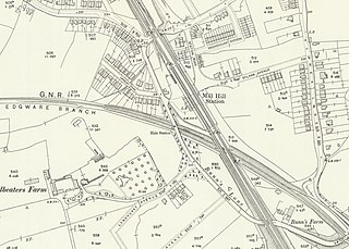
Mill Hill (The Hale) was a station in Mill Hill in north London, on the now-removed railway between Mill Hill East station and Edgware railway station. It was located near the junction of Bunns Lane and Lyndhurst Avenue.

<span class="mw-page-title-main">Edgware railway station</span> Former railway station in England

Edgware was a London and North Eastern Railway (LNER) station located on Station Road in Edgware, north London. It was opened in 1867 and was in use as a passenger station until 1939, then as a goods yard until 1964.

Elstree South was a proposed London Underground station in Elstree, Hertfordshire. It was designed by Charles Holden. The planned location of the station was adjacent to the A5183, north of the junction with the A41 and where junction 4 of the M1 motorway was subsequently built.

Bushey Heath was a proposed, but unbuilt, London Underground station in Bushey Heath, Hertfordshire, England. The planned location of the station was at the junction of the A41 and A411 roads.

The New Works Programme of 1935–1940 was the major investment programme delivered by the London Passenger Transport Board (LPTB), commonly known as London Transport, which had been created in 1933 to coordinate underground train, tram, trolleybus and bus services in the capital and the surrounding areas. The programme was to develop many aspects of the public transport services run by the LPTB and the suburban rail services of the Great Western Railway (GWR) and London and North Eastern Railway (LNER). The investment was largely backed by government assistance as well as by the issuing of financial bonds and was estimated to cost £42,286,000 in 1936.

The Watford and Edgware Railway (W&ER) was a company established in the 1860s in the United Kingdom to build a railway between Edgware in North London and Watford, Hertfordshire, via Bushey. Its planned 6.25-mile (10.06 km) route would have extended the railway line which forms part of the present-day Northern line on the London Underground network. Nothing substantial was constructed.

<span class="mw-page-title-main">Brockley Hill</span> Area of high ground in England

Brockley Hill, Stanmore, is an area of high ground on the outskirts of North London, England. The hill, which rises to 136 metres (446 ft) above sea level, is traversed by the A5 road. It follows the course of the Roman road known as Watling Street. The hill is also associated with the Roman archaeological site called Sulloniacis. The Royal National Orthopaedic Hospital is based at Brockley Hill.

The transport system now known as the London Underground began in 1863 with the Metropolitan Railway, the world's first underground railway. Over the next forty years, the early sub-surface lines reached out from the urban centre of the capital into the surrounding rural margins, leading to the development of new commuter suburbs. At the turn of the nineteenth century, new technology—including electric locomotives and improvements to the tunnelling shield—enabled new companies to construct a series of "tube" lines deeper underground. Initially rivals, the tube railway companies began to co-operate in advertising and through shared branding, eventually consolidating under the single ownership of the Underground Electric Railways Company of London (UERL), with lines stretching across London.

<span class="mw-page-title-main">Edgware Way Grassland</span>

Edgware Way Grassland or Edgware Way Rough is a 6.7-hectare (17-acre) Site of Metropolitan Importance for Nature Conservation in Edgware in the London Borough of Barnet. It is traversed by Edgwarebury Brook and contains traces of a planned railway viaduct and embankment. This was part of a planned extension of the Northern line from Edgware to Bushey, which was cancelled when the introduction of the Green Belt after the Second World War led to the cancellation of the developments which the railway was to serve. Part of the site is the Environment Agency's Edgwarebury Park Flood Storage Area.

References

  1. 1 2 Horne 2009, p. 42.
  2. 1 2 Beard 2002, pp. 60–64.
  3. 1 2 Beard 2002, p. 14.
  4. Beard 2002, p. 86.
  5. Beard 2002, pp. 56–57.
  6. Beard 2002, p. 18.
  7. Beard 2002, p. 28.
  8. Beard 2002, pp. 27–28.
  9. Beard 2002, p. 53.
  10. 1 2 Beard 2002, p. 72–73.
  11. Beard 2002, p. 82.
  12. Beard 2002, p. 72.
  13. 1 2 Beard 2002, p. 90.
  14. Beard 2002, p. 92.
  15. Horne 2009, p. 51.
  16. Beard 2002, p. 126.
  17. 1 2 Beard 2002, p. 127.
  18. 1 2 3 Beard 2002, p. 132.
  19. Rose 2016.
  20. Beard 2002, p. 32.
  21. 1 2 Beard 2002, pp. 32–33.

Bibliography

  • Beard, Tony (2002). By Tube Beyond Edgware. Capital Transport. ISBN   978-1-85414-246-7.
  • Horne, Mike (2009) [1990]. The Northern Line, An Illustrated History (3rd ed.). Capital Transport. ISBN   978-1-85414-326-6.
  • Rose, Douglas (2016) [1980]. The London Underground, A Diagrammatic History (9th ed.). Douglas Rose/Capital Transport. ISBN   978-1-85414-404-1.
Abandoned Northern Heights Extension
Preceding station Underground no-text.svg London Underground Following station
Elstree South
towards Bushey Heath
Northern line
Edgware
towards Morden or Kennington