The exclusivity of Chelsea as a result of its high property prices historically resulted in the coining of the term "Sloane Ranger" in the 1970s to describe some of its residents, and some of those of nearby areas. Chelsea is home to one of the largest communities of Americans living outside the United States, with 6.53% of Chelsea residents having been born in the U.S.[2]
The word Chelsea (also formerly Chelceth, Chelchith, or Chelsey,[3]) originates from the Old English term for "landing place [on the river] for chalk or limestone" (Cealc-hyð: chalk-wharf, in Anglo-Saxon). Chelsea hosted the Synod of Chelsea in 787 AD. The first record of the Manor of Chelsea precedes the Domesday Book and records the fact that Thurstan, governor of the King's Palace during the reign of Edward the Confessor (1042–1066), gave the land to the Abbot and Convent of Westminster. From at least this time, up to 1900, the Manor and Parish of Chelsea included a 144-acre exclave which is now known as Kensal Town. The exclave, which was once heavily wooded, was sometimes also known as Chelsea-in-the-Wilderness.[4]
Abbot Gervace subsequently assigned the manor to his mother, and it passed into private ownership. By 1086 the Domesday Book records that Chelsea was in the hundred of Ossulstone in Middlesex, with Edward of Salisbury as tenant-in-chief.[5]
By 1694, Chelsea – always a popular location for the wealthy, and once described as "a village of palaces" – had a population of 3,000. Even so, Chelsea remained rural and served London to the east as a market garden, a trade that continued until the 19th-century development boom which caused the final absorption of the district into the metropolis. The street crossing that was known as Little Chelsea, Park Walk, linked Fulham Road to King's Road and continued to the Thames and local ferry down Lover's Lane, renamed "Milmans Street" in the 18th century.
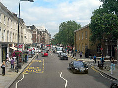
King's Road, named for Charles II, recalls the King's private road from St James's Palace to Fulham, which was maintained until the reign of George IV. One of the more important buildings in King's Road, the former Chelsea Town Hall, popularly known as "Chelsea Old Town hall" – a fine neo-classical building – contains important frescoes. Part of the building contains the Chelsea Public Library. Almost opposite stands the former Odeon Cinema, now Habitat, with its iconic façade which carries high upon it a large sculptured medallion of the now almost-forgotten William Friese-Greene, who claimed to have invented celluloid film and cameras in the 1880s before any subsequent patents.
In 1718, the Raw Silk Company was established in Chelsea Park, with mulberry trees and a hothouse for raising silkworms. At its height in 1723, it supplied silk to Caroline of Ansbach, then Princess of Wales.[6]
Chelsea once had a reputation for the manufacture of Chelsea buns, made from a long strip of sweet dough tightly coiled, with currants trapped between the layers, and topped with sugar. The Chelsea Bun House sold these during the 18th century and was patronised by the Georgian royalty. At Easter, great crowds would assemble on the open spaces of the Five Fields – subsequently developed as Belgravia. The Bun House would then do a great trade in hot cross buns and sold about quarter of a million on its final Good Friday in 1839.[7][8]
The area was also famous for its "Chelsea China" ware, though the works, the Chelsea porcelain factory – thought to be the first workshop to make porcelain in England – were sold in 1769, and moved to Derby. Examples of the original Chelsea ware fetch high values.
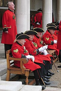
The best-known building is Chelsea Royal Hospital for old soldiers, set up by Charles II (supposedly on the suggestion of Nell Gwynne), and opened in 1694. The beautifully proportioned building by Christopher Wren stands in extensive grounds, where the Chelsea Flower show is held annually. The former Duke of York's Barracks (built 1801–3) off King's Road is now part of Duke of York Square, a redevelopment including shops and cafes and the site of a weekly "farmers' market". The Saatchi Gallery opened in the main building in 2008. Chelsea Barracks, at the end of Lower Sloane Street, was also in use until recently, primarily by ceremonial troops of the Household Division. Situated on the Westminster side of Chelsea Bridge Road, it was bought for re-development by a property group from Qatar.
St Mark's College, Chelsea, was founded in 1841, based on the beliefs of The Reverend Derwent Coleridge, son of the poet Samuel Taylor Coleridge, its first principal: that its primary purpose was to widen the educational horizons of its students. During the First World War, St Mark's College was requisitioned by the War Office to create the 2nd London General Hospital, a facility for the Royal Army Medical Corps to treat military casualties.[9] It merged with St John's College, Battersea, in 1923, establishing a single institution in Chelsea as the College of St Mark & St John. In 1973 it moved to Plymouth, having outgrown the Chelsea campus. The former chapel of St Mark's College, designed by Edward Blore is on the Fulham Road, Chelsea, and is now a private residence.[10]
Dring the mid-1800s, Cremorne Gardens, London, was a popular pleasure gardens area established in 1845. It continued to operate until 1877. The area lay between Chelsea Harbour and the end of the King's Road.
Chelsea's modern reputation as a centre of innovation and influence originated in a period during the 19th century, when the area became a Victorian artists' colony (see Borough of artists below). It became prominent once again as one of the centres of the "Swinging London" of the 1960s, when house prices were lower than in the staid Royal Borough of Kensington.
The borough of artists
Chelsea once had a reputation as London's bohemian quarter, the haunt of artists, radicals, painters and poets. Little of this seems to survive now – the comfortable squares off King's Road are homes to, amongst others, investment bankers and film stars. The Chelsea Arts Club continues in situ; however, the Chelsea College of Art and Design, founded in 1895 as the Chelsea School of Art, moved from Manresa Road to Pimlico in 2005.
The Chelsea Book Club, at no. 65 Cheyne Walk (Lombard Terrace), a bookshop that also presented exhibitions and lectures, held the first exhibition of African art in London (sculpture from Ivory Coast and Congo) in 1920, and was the first bookshop to stock Joyce's Ulysses in 1922. Sold in 1928 owing to financial problems, it became the Lombard Restaurant.[11]
Oscar Wilde's house on Tite Street, ChelseaCrosby Hall on Cheyne Walk. Parts of this building date back to the time of Richard III, its first owner. But it is not native to Chelsea – it is a survivor of the Great Fire of London. It was shipped brick by brick from Bishopsgate in 1910 after being threatened with demolition. (January 2006)
The architect John Samuel Phene lived at No.2 Upper Cheyne Row between 1903 and his death in 1912. He installed numerous artefacts and objets d'art around the house and gardens and it was known locally as the "Gingerbread Castle". It was demolished in 1924.[12]
In a book, Bohemia in London by Arthur Ransome which is a partly fictional account of his early years in London, published in 1907 when he was 23, there are some fascinating, rather over-romanticised accounts of bohemian goings-on in the quarter. The American artist Pamela Colman Smith, the designer of A. E. Waite's Tarot card pack and a member of the Hermetic Order of the Golden Dawn, features as "Gypsy" in the chapter "A Chelsea Evening".
A central part of Chelsea's artistic and cultural life was Chelsea Public Library, originally situated in Manresa Road. Its longest-serving member of staff was Armitage Denton, who joined in 1896 at the age of 22, and he remained there until his retirement in 1939; he was appointed Chief Librarian in 1929. In 1980, the building was purchased by Chelsea College of Art and Design.
The Chelsea Society, formed in 1927, remains an active amenity society concerned with preserving and advising on changes in Chelsea's built environment. Chelsea Village and Chelsea Harbour are new developments outside of Chelsea itself.
Swinging Chelsea
Chelsea shone again, brightly but briefly, in the 1960s Swinging London period and the early 1970s. The Swinging Sixties was defined on King's Road, which runs the length of the area. The Western end of Chelsea featured boutiques Granny Takes a Trip and The Sweet Shop, the latter of which sold medieval silk velvet caftans, tabards and floor cushions, with many of the cultural cognoscenti of the time being customers, including Twiggy and many others.
The "Chelsea girl" was a symbol, media critic John Crosby wrote, of what "men [found] utterly captivating", flaunting a "'life is fabulous' philosophy".[13] Chelsea at this time was home to the Beatles and to Rolling Stones members Brian Jones, Mick Jagger, and Keith Richards. In the 1970s, the World's End area of King's Road was home to Malcolm McLaren and Vivienne Westwood's boutique "SEX" (at Number 430, the King's Road), and saw the birth of the British punk movement.
Chelsea Manor was served by the ancient parish of Chelsea. (Such parish units were typically in place by the end of the twelfth century with their boundaries, based on those of the constituent manor or manors, rarely if ever changing.[15]) The manor and parish formed part of the OssulstoneHundred of the county of Middlesex.
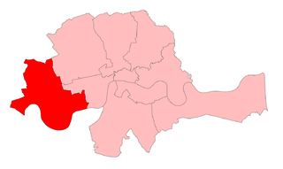
The Chelsea parliamentary constituency (1885) was coterminous with the ancient parish of Chelsea. The northern exclave of Kensal Town is shown.The Metropolitan Borough of Chelsea in 1916
The parish and borough of Chelsea, which now forms the southern part of the Royal Borough of Kensington and Chelsea, was bounded by rivers on three sides with Fulham Road forming part of its northern boundary with Kensington.
The short western boundary with Fulham was formed by the former Counter's Creek, of which the mouth - Chelsea Creek - is the only surviving part, with the river's route now used by the West London Line. Chelsea Football Club's Stamford Bridge home, lies just west of the Counter's Creek in Fulham, and takes its name from a bridge which carried the Fulham Road over the river. The bridge was also known as Little Chelsea Bridge.[17]
This former fashionable village was absorbed into London during the eighteenth century. Many notable people of 18th-century London, such as the bookseller Andrew Millar, were both married and buried in the district.[18]
As well as a number of garden squares, Chelsea has several open spaces including Albert Bridge Gardens, Battersea Bridge Gardens, Chelsea Embankment Gardens, the Royal Hospital Chelsea (the grounds of which are used by the annual Chelsea Flower Show) and Chelsea Physic Garden.[19]
In the 18th century, Chelsea Cricket Club was prominent for a time and played its home matches on what was then Chelsea Common, an area that virtually disappeared under building work in the 19th century.[20] Records have survived of five matches between 1731 and 1789 which involved the Chelsea club and/or were played on the common.[21][22]
Chelsea Football Club is located at Stamford Bridge in neighbouring Fulham, adjacent to the border with Chelsea. As a result of Chelsea's expensive location and wealthy residents, Chelsea F.C. has the wealthiest local supporters in England.[23]
There is a proposal to construct a Chelsea Underground station on the King's Road as part of the Crossrail 2 project (also known as the Chelsea-Hackney line). The project, run by Transport for London, has not yet been approved or funded but is at the consultation stage.[25] According to plans published by TfL in 2008, it is envisaged that the station would be located on the Dovehouse Green area of King's Road.[26] In late 2020 central government shelved plans to progress the Crossrail 2 project.[27]
Kensington is an area of London in the Royal Borough of Kensington and Chelsea, around 2.9 miles (4.6 km) west of Central London.
The Royal Borough of Kensington and Chelsea is an Inner London borough with royal status. It is the smallest borough in London and the second smallest district in England; it is one of the most densely populated administrative regions in the United Kingdom. It includes affluent areas such as Notting Hill, Kensington, South Kensington, Chelsea, and Knightsbridge.
Notting Hill is a district of West London, England, in the Royal Borough of Kensington and Chelsea. Notting Hill is known for being a cosmopolitan and multicultural neighbourhood, hosting the annual Notting Hill Carnival and the Portobello Road Market. From around 1870, Notting Hill had an association with artists.
The London Borough of Hammersmith and Fulham is a London borough in West London and which also forms part of Inner London. The borough was formed in 1965 from the merger of the former Metropolitan Boroughs of Hammersmith and Fulham. The borough borders Brent to the north, the Royal Borough of Kensington and Chelsea to the east, Wandsworth to the south, Richmond upon Thames to the south west, and Hounslow and Ealing to the west.
Fulham is an area of the London Borough of Hammersmith & Fulham in West London, England, 3.6 miles (5.8 km) southwest of Charing Cross. It lies on the north bank of the River Thames, bordering Hammersmith, Kensington and Chelsea. The area faces Wandsworth, Putney, Barn Elms and the London Wetland Centre in Barnes. on the far side of the river.
Earl's Court is a district of Kensington in the Royal Borough of Kensington and Chelsea in West London, bordering the rail tracks of the West London line and District line that separate it from the ancient borough of Fulham to the west, the sub-districts of South Kensington to the east, Chelsea to the south and Kensington to the northeast. It lent its name to the now defunct eponymous pleasure grounds opened in 1887 followed by the pre–World War II Earls Court Exhibition Centre, as one of the country's largest indoor arenas and a popular concert venue, until its closure in 2014.
The Metropolitan Borough of Chelsea was a metropolitan borough of the County of London between 1900 and 1965. It was created by the London Government Act 1899 from most of the ancient parish of Chelsea. Following the London Government Act 1963, it was amalgamated with the Royal Borough of Kensington in 1965 to form the Royal Borough of Kensington and Chelsea.
King's Road or Kings Road is a major street stretching through Chelsea and Fulham, both in west London, England. It is associated with 1960s style and with fashion figures such as Mary Quant and Vivienne Westwood. Sir Oswald Mosley's Blackshirt movement had a barracks on the street in the 1930s.
South Kensington is a district just west of Central London in the Royal Borough of Kensington and Chelsea. Historically it settled on part of the scattered Middlesex village of Brompton. Its name was supplanted with the advent of the railways in the late 19th century and the opening and naming of local tube stations. The area has many museums and cultural landmarks with a high number of visitors, such as the Natural History Museum, the Science Museum and the Victoria and Albert Museum. Adjacent affluent centres such as Knightsbridge, Chelsea and Kensington, have been considered as some of the most exclusive real estate in the world.
Counter's Creek, ending in Chelsea Creek, the lowest part of which still exists, was a stream that flowed from Kensal Green, by North Kensington and flowed south into the River Thames on the Tideway at Sands End, Fulham. Its remaining open watercourse is the quay of Chelsea Creek.
West Kensington, formerly North End, is an area in the ancient parish of Fulham, in the London Borough of Hammersmith and Fulham, England, 3.4 miles (5.5 km) west of Charing Cross. It covers most of the London postal area of W14, including the area around Barons Court tube station, and is defined as the area between Lillie Road and Hammersmith Road to the west, Fulham Palace Road to the south, Hammersmith to the north and West Brompton and Earl's Court to the east. The area is bisected by the major London artery the A4, locally known as the Talgarth Road. Its main local thoroughfare is the North End Road.
Fulham Road is a street in London, England, which comprises the A304 and part of the A308.
Brompton, sometimes called Old Brompton, survives in name as a ward in the Royal Borough of Kensington and Chelsea in London. Until the latter half of the 19th century it was a scattered village made up mostly of market gardens in the county of Middlesex. It lay south-east of the village of Kensington, abutting the parish of St Margaret's, Westminster at the hamlet of Knightsbridge to the north-east, with Little Chelsea to the south. It was bisected by the Fulham Turnpike, the main road westward out of London to the ancient parish of Fulham and on to Putney and Surrey. It saw its first parish church, Holy Trinity Brompton, only in 1829. Today the village has been comprehensively eclipsed by segmentation due principally to railway development culminating in London Underground lines, and its imposition of station names, including Knightsbridge, South Kensington and Gloucester Road as the names of stops during accelerated urbanisation, but lacking any cogent reference to local history and usage or distinctions from neighbouring settlements.
Ossulstone is an obsolete subdivision (hundred) covering 26.4% of – and the most metropolitan part – of the historic county of Middlesex, England. It surrounded but did not include the City of London and the area has been entirely absorbed by the growth of London. It now corresponds to the seven London Boroughs of Inner London north of the Thames and, from Outer London, in decreasing order, certain historic parishes of the London boroughs of Ealing, Brent, Barnet, and Haringey.
West Brompton is an area of west London, England, that straddles the boundary between the London Borough of Hammersmith and Fulham and Royal Borough of Kensington and Chelsea. The centuries-old boundary was traced by Counter's Creek, now lost beneath the West London Line railway.
Chelsea was a borough constituency, represented in the House of Commons of the Parliament of the United Kingdom.
The Kensington Division was one of four divisions of the Hundred of Ossulstone, in the county of Middlesex, England. The other divisions were named Finsbury, Holborn and Tower. Ossulstone hundred was divided in the seventeenth century, with each of the four divisions replacing the hundred for most administrative purposes.
Cadogan Group Limited and its subsidiaries, including Cadogan Estates Limited, are British property investment and management companies that are owned by the Cadogan family, one of the richest families in the United Kingdom. They also hold the titles of Earl Cadogan and Viscount Chelsea, the latter used as a courtesy title by the Earl's eldest son. The Cadogan Group is the main landlord in the west London districts of Chelsea and Knightsbridge, and it is now the second largest of the surviving aristocratic Freehold Estates in Central London, after the Duke of Westminster's Grosvenor Estate, to which it is adjacent, covering Mayfair and Belgravia.
Walham Green is the historic name of an English village, now part of inner London, in the parish of Fulham in the County of Middlesex. It was located between the hamlet of North End to the north, and Parsons Green to the south. To the east it was bounded by Counter's Creek, the historical boundary with the parish of Chelsea, and to the south-east is Sands End.
King's Road Chelsea railway station is a proposed station on Crossrail 2, a planned underground railway line through London in the United Kingdom. If constructed, the station would serve the King's Road area of Chelsea.
↑ Patricia E.C. Croot, ed. (2004). "Economic history: Trade and industry". A History of the County of Middlesex: Volume 12: Chelsea. Institute of Historical Research.
↑ "Chelsea Bun House", London Encyclopaedia, Pan Macmillan, 2010, p.155, ISBN9781405049252
↑ George Bryan (1869), "The Original Chelsea Bunhouse", Chelsea, in the Olden & Present Times, London, pp.200–202{{citation}}: CS1 maint: location missing publisher (link)
↑ This is based on the typical formation date of English parishes and that boundaries were very difficult to change; Churches in the landscape, Richard Morris, (1989) ISBN 9780460045094, pp. 169-171.
↑ The London Encyclopaedia, Weinreb and Hibbert, p 633
This page is based on this Wikipedia article Text is available under the CC BY-SA 4.0 license; additional terms may apply. Images, videos and audio are available under their respective licenses.