Edgware is a suburban town in northern Greater London, mostly in the London Borough of Barnet but with some parts falling in the London Borough of Harrow and in the London Borough of Brent. Edgware is centred 9.5 miles (15.3 km) north-northwest of Charing Cross and has its own commercial centre. Edgware has a generally suburban character, typical of the rural-urban fringe. It was an ancient parish in the county of Middlesex directly east of the ancient Watling Street, and gives its name to the present day Edgware Road that runs from central London towards the town. The community benefits from some elevated woodland on a high ridge marking the Hertfordshire border of gravel and sand.

Finchley is a large district of north London, England, in the London Borough of Barnet. Finchley is on high ground, 7 mi (11 km) north of Charing Cross. Nearby districts include: Golders Green, Muswell Hill, Friern Barnet, Whetstone, Mill Hill and Hendon.
Hendon is an urban area in the London Borough of Barnet, northwest London 7 miles (11 km) northwest of Charing Cross. Hendon was an ancient manor and parish in the county of Middlesex and a former borough, the Municipal Borough of Hendon; it has been part of Greater London since 1965. Hendon falls almost entirely within the NW4 postcode, while the West Hendon part falls in NW9. Colindale to the northwest was once considered part of Hendon but is today separated by the M1 motorway.

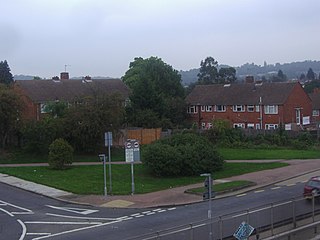
Mill Hill is a suburb in the London Borough of Barnet, England. It is situated around 9 miles (14 km) northwest of Charing Cross, close to the Hertfordshire border. It was in the historic county of Middlesex until 1965, when it became part of Greater London. Its population was 18,451 in 2011.

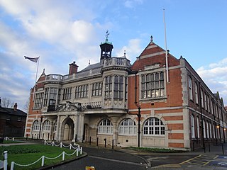
The London Borough of Barnet is a local authority area on the northern outskirts of London. The borough was formed in 1965 from parts of the ceremonial counties of Middlesex and Hertfordshire. It is the second largest London borough by population with 389,344 inhabitants as of 2021, also making it the 17th largest district in England. The borough covers an area of 86.74 square kilometres (33 sq mi), the fourth highest of the 32 London boroughs, and has a population density of 45.8 people per hectare, which ranks it 25th.

East Finchley is a London Underground station in East Finchley in the London Borough of Barnet, north London. The station is on the High Barnet branch of the Northern line, between Finchley Central and Highgate stations, and is in Travelcard Zone 3.

North Finchley is a suburb of London in the London Borough of Barnet, situated 7 miles (11 km) north-west of Charing Cross. North Finchley is centred on Tally Ho Corner, the junction of the roads to East Finchley, Church End, Friern Barnet and Whetstone. Church End is often known as Finchley Central, owing to the name of the tube station located there.

Brent Cross is a major traffic interchange and area in the London Borough of Barnet, England. Originally the name of a crossroads, it is located a mile from the centres of Hendon and Golders Green. Notably, the Brent Cross Shopping Centre, a major retail facility, was opened in 1976, south of the interchange. The "Brent Cross Flyover" A41 runs to the east of the shopping centre over the A406 North Circular Road, while the M1 motorway and A5 Edgware Road are to the west at Staples Corner interchange. In addition, the Northern line and Thameslink rail routes run on viaducts.

Finchley Central is a London Underground station in the Church End area of Finchley, north London. The station is located on the High Barnet branch of the Northern line, between West Finchley and East Finchley stations; it is the junction for the short branch to Mill Hill East. The station is around 7 miles north-northwest of Charing Cross and is in Travelcard Zone 4.

Burnt Oak is a suburb of London, England, located 9 miles (14 km) northwest of Charing Cross. It lies to the west of the M1 motorway between Edgware and Colindale, located predominantly in the London Borough of Barnet, with parts in the London Boroughs of Brent and Harrow. It was part of Middlesex until it was transferred to Greater London in 1965.
West Hendon is a district of Hendon in North London, in the London Borough of Barnet. It is the NW9 part of Hendon, located around the A5 Edgware Road and the Welsh Harp. The area is known for the West Hendon Estate which is undergoing controversial regeneration.

Colindale is a district in the London Borough of Barnet; its main shopping street on the A5 forming the borough boundary with neighbouring Brent. Colindale is a suburban area, and in recent years has had many new apartments built. It is also the location of the 1960s–1970s Grahame Park housing estate, built on former parts of Hendon Aerodrome. It is situated about eight miles northwest of Charing Cross, directly northwest of Hendon, to the south of Edgware and east of Queensbury.

The Edgware, Highgate and London Railway was a railway in North London, England. The railway was a precursor of parts of London Underground's Northern line and was, in the 1930s, the core of an ambitious expansion plan for that line which was thwarted by the Second World War. Parts of the line were closed in the 1950s and have since been removed.

Cranley Gardens railway station was a station in the Muswell Hill area of north London. It was located between Highgate and Muswell Hill stations, at the junction of Muswell Hill Road and Cranley Gardens. Nothing remains of the station today and its site is now occupied by housing and a school. In the 1930s, plans were made to electrify the line and transfer the mainline service to London Underground's Northern line, but these were abandoned after the Second World War. The station closed for passengers in 1954 and for goods in 1957.

Stroud Green railway station is a former station in the Stroud Green area of north London. It was located between Finsbury Park station and Crouch End station on a bridge over Stapleton Hall Road. The station had platforms cantilevered from the bridge structure and a wooden station building at ground level under and on either side of the bridge, with a station master's house to the north of it. The bridge still exists and now carries the Parkland Walk cycle and pedestrian path, whilst the station master's house serves as a community centre.

Crouch End railway station is a former station in the Crouch End area of north London. It was located between Stroud Green station and Highgate station on Crouch End Hill just north of its junction with Hornsey Lane. The station building was located on the road bridge over the railway but only small parts remain of the structure today.
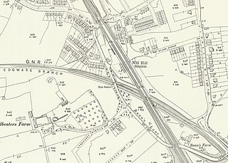
Mill Hill (The Hale) was a station in Mill Hill in north London, on the now-removed railway between Mill Hill East station and Edgware railway station. It was located near the junction of Bunns Lane and Lyndhurst Avenue.

Edgware was a London and North Eastern Railway (LNER) station located on Station Road in Edgware, north London. It was opened in 1867 and was in use as a passenger station until 1939, then as a goods yard until 1964.

London Buses route 240 is a Transport for London contracted bus route in London, England. Running between Golders Green station and Edgware bus station, it is operated by Metroline.
Broadfields or the Broadfields Estate is a neighbourhood of Edgware in the London Borough of Barnet in northwest London, UK.


