
Paddington is an area in the City of Westminster, in central London, England. A medieval parish then a metropolitan borough of the County of London, it was integrated with Westminster and Greater London in 1965. Paddington station, designed by the engineer Isambard Kingdom Brunel opened in 1847. It is also the site of St Mary's Hospital and the former Paddington Green Police Station.
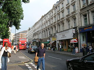
Westbourne Grove is a retail road running across Notting Hill, an area of west London. Its western end is in the Royal Borough of Kensington and Chelsea and its eastern end is in the City of Westminster; it runs from Kensington Park Road in the west to Queensway in the east, crossing over Portobello Road. It contains a mixture of independent and chain retailers, and has been termed both "fashionable" and "up-and-coming".

Ossington Street is a quiet one-way street in London, W2, leading from Moscow Road at its north end to the Bayswater Road / Notting Hill Gate at its south end.

Bayswater Road is the main road running along the northern edge of Hyde Park in London. Originally part of the A40 road, it is now designated part of the A402 road.

Essex Road is a main road in Islington, London. It is part of the A104 and connects Islington High Street with Balls Pond Road via Essex Road railway station.

Harrow Road is an ancient route in North West London which runs from Paddington in a northwesterly direction towards Harrow. It is also the name given to the immediate surrounding area of Queens Park and Kensal Green, straddling the NW10, W10, W2 and W9 postcodes. With minor deviations in the 19th and 20th centuries, the route remains otherwise unaltered.

Leinster Gardens is a street in Bayswater, London. It is lined with tall, ornate, mid-Victorian terraced houses, many of which are listed buildings.
The A1206, also known as the Isle of Dogs Distributor Road, is a crescent-shaped ring road around the Isle of Dogs, in the East End of London. It is made up of Westferry Road, Manchester Road and Prestons Road and is the main road through the area, connecting parts of the London Docklands.

Kilburn Priory was a small monastic community of nuns established around 1130–1134 three miles north-west of the City of London, where Watling Street met the stream now known as the Westbourne, but variously known as Cuneburna, Keneburna, Keeleburne, Coldburne, or Caleburn, meaning either the royal or cow's stream. The priory gave its name to the area now known as Kilburn, and the local streets Priory Road, Kilburn Priory, Priory Terrace, and Abbey Road. Kilburn Lane connected the priory to the village of Kensal to the west.

Warwick Avenue is a residential avenue in the Little Venice area of Maida Vale, London. Its southern end is situated adjacent to Paddington Basin, to the north of Paddington station.
Flood Street is a residential street in Chelsea, London, England. It runs between King's Road to the north and Royal Hospital Road to the south. Just further to the south is the River Thames. The closest tube station is Sloane Square to the northeast. The street commemorates Luke Thomas Flood, a major Chelsea land owner and a benefactor of the poor.
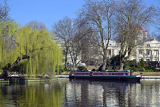
Little Venice is an affluent residential district in West London, England, around the junction of the Paddington Arm of the Grand Union Canal, the Regent's Canal, and the entrance to Paddington Basin. The junction, also known as Little Venice and Browning's Pool, forms a triangular shape basin designed to allow long canal boats to turn around. Many of the buildings in the vicinity are Regency white painted stucco terraced town houses and taller blocks (mansions) in the same style. The area is 2.5 miles (4.0 km) west-north-west of Charing Cross and immediately north-west of Paddington.

Chepstow Place is a street in London that runs from the junction of Westbourne Grove and Pembridge Villas in the north to Pembridge Square in the south. It is crossed by Dawson Place and joined on its eastern side by Rede Place. The east side is in the City of Westminster and the west side in the Royal Borough of Kensington and Chelsea.

Cleveland Square is a private and gated garden square in the predominantly classically conserved Bayswater district of the City of Westminster, north of Central London's Hyde Park. The housing is in tall, tree-shaded rows, stuccoed and with pillared porches, with some discreet infilling of other housing behind.
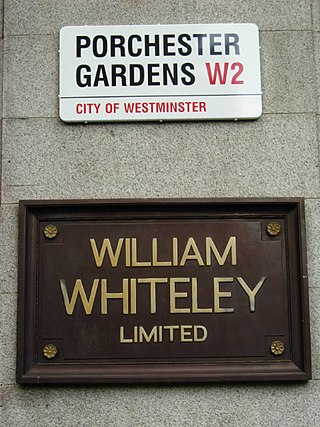
Porchester Gardens is a street in the Bayswater area of London. Located in the City of Westminster, it runs east to west and crosses Queensway. Like several streets in the area it was developed by Edward Orme. In 1879 the engineer R. E. B. Crompton lit his house by electricity, effectively the first in London to do so. The department store Whiteleys was located where the two streets joined before its closure. The road features a mixture of residential and commercial properties. At the eastern end, Porchester Terrace runs southwards to Kensington Gardens while in the west it ultimately merges into Kensington Gardens Square and Leinster Square. Moscow Road runs parallel to the south for much of the route.
Randolph Avenue is a street in Maida Vale in London. Located in the City of Westminster, it is a long avenue running from north to south. The southern end is located in Little Venice near to the Paddington branch of the Grand Union Canal. The street runs northwards, crossing Clifton Gardens, Sutherland Avenue, Elgin Avenue and Carlton Vale. The road then continues as Randolph Gardens until it meets Kilburn Park Road. The Edgware Road runs directly parallel to Randolph Avenue to the east.

Warrington Crescent is a street in Maida Vale in London. Located in the City of Westminster, it is a crescent curving north eastwards from Warwick Avenue until it reaches a roundabout where it meets including Randolph Avenue, Sutherland Avenue and Lauderdale Road. Warrington Gardens and Formosa Street both lead westwards off Warrington Crescent.
Sutherland Avenue is a street in Maida Vale in London, England. Located in the City of Westminster on the northern edge of Little Venice. it is an avenue running east to west from the Edgware Road to Harrow Road. Along the route it is crossed or joined by Randolph Avenue, Warrington Crescent, Lauderdale Road, Castellian Road, Warwick Avenue and Shirland Road. Elgin Avenue runs directly parallel to the north.

Arlington Road is a street running between Mornington Crescent and Camden Town in the London Borough of Camden, England. It runs south to north, directly parallel to Camden High Street to its east. It is crossed by Inverness Street, Parkway and Delancey Street. It is near Gloucester Crescent. It is mainly residential, with a few commercial properties.

Albion Street is a residential street located in Central London in the City of Westminster. Part of the Tyburnia area, it runs southwards from Connaught Street to the Bayswater Road on the edge of Hyde Park. It is notable for its Regency architecture.
