De Beauvoir Town

Last updated • 8 min readFrom Wikipedia, The Free Encyclopedia

De Beauvoir Town
Aerial view of de beauvoir square 1.jpg
Aerial view of De Beauvoir Square
Greater London UK location map 2.svg
Red pog.svg
De Beauvoir Town
Location within Greater London
OS grid reference TQ3384
  Charing Cross 3.8 mi (6.1 km)  SW
London borough
Ceremonial county Greater London
Region
Country England
Sovereign state United Kingdom
Post town LONDON
Police Metropolitan
Fire London
Ambulance London
UK Parliament
London Assembly
List of places
UK
England
London
51°32′37″N0°04′50″W / 51.5437°N 0.0805°W / 51.5437; -0.0805

De Beauvoir Town is a neighbourhood in the London Borough of Hackney, 2 miles (3.2 km) north of the City of London. It is sometimes described as a part of Dalston. [1] The name is pronounced variously; notably /dəˈbvər/ (BEE-vər) and /diˈbvwɑːr/ (dee BOH-vwar), with the former giving rise to its traditional cockney nickname Beavertown. [2]

Contents

The area, then in the ancient parish of Hackney, was developed in the mid-19th century. Most of its development was carried out as part of a plan for new town to attract prosperous residents, though it includes a range of housing types and other land uses. The new town was based around De Beauvoir Square and primarily built in the Jacobethan style.

The special character of the neighbourhood has been retained and is recognised by the designation of the De Beauvoir [3] and Kingsland Road [4] Conservation Areas which include many listed and other notable buildings.

Boundaries

Its boundaries are defined by its highly geometric streets and an early 19th century canal. They are: Kingsland Road to the east, Regents Canal to the south, Southgate Road to the west and Balls Pond Road to the north; the middle of the last two roads marks the border of the London Boroughs of Hackney and Islington. The area enclosed by these roads is just over 0.7 square kilometres (0.27 sq mi). Direct neighbours are Canonbury, Dalston, Hoxton and Haggerston areas.

History

19th century

Until 1820 the area now covered by De Beauvoir Town was open country with a few grand houses. In 1821, stimulated by the opening of the Regent's Canal the previous year, developer and brickmaker William Rhodes (1774–1843), a grandfather of Cecil Rhodes, [5] secured a lease for 150 acres (0.61 km2) of land from Peter de Beauvoir. [6] Rhodes planned to build residences for the upper classes set on wide streets in a grid pattern, with four squares on diagonal streets intersecting at an octagon. However, work stopped in 1823 when Rhodes was found to have obtained his lease unfairly and after a court case spanning over 20 years the land reverted to the de Beauvoir family in 1834. [7]

The distinctive Jacobethan styled gables and mullioned windows of houses in De Beauvoir Square De beauvoir square1.jpg
The distinctive Jacobethan styled gables and mullioned windows of houses in De Beauvoir Square

The delay in the building had meant that Rhodes' clientele had since moved on to the new suburbs of the West End. The scheme was scaled down and of the planned squares only the southeastern was built, as De Beauvoir Square, although the diagonals partly survived in Enfield Road, Stamford Road and Ardleigh Road. Occupied in the 1840s by the newly emerging middle classes, the estate was almost wholly residential except around Kingsland Basin and the south-west corner where a factory was leased from 1823. [7]

20th century

De Beauvoir Estate, completed in 1971 De-beauvour-new2.jpg
De Beauvoir Estate, completed in 1971

In 1907, the Fifth Congress of the Russian Social Democratic Labour Party was held at the Brotherhood Church on the east side of Southgate Road. Attendees included Lenin, Stalin, Maxim Gorky, Rosa Luxemburg and Leon Trotsky. The congress debated strategy for a communist revolution in Russia and strengthened the position of Lenin's Bolsheviks. [9]

In 1937, due to its easy access to Kingsland Basin, the southeast corner between Downham Road and Hertford Road was re-zoned for industrial use. Soon afterwards, the areas south of Downham Road were included. These were distinguished from the north side, which was already zoned for business and acted as a buffer for the mainly residential streets beyond. In 1938 De Beauvoir Crescent was suggested as another business zone to protect housing to the north.

De Beauvoir Square in the summer Aerial view of de beauvoir square 2.jpg
De Beauvoir Square in the summer

In the early 1960s the northern part of De Beauvoir Town between Buckingham Road and Tottenham Road was rebuilt as the Metropolitan Borough of Hackney's Kingsgate estate. In the late 1960s a larger area west of the canal basin, which contained many small factories, made way for the De Beauvoir Estate. The east side of De Beauvoir Square was also rebuilt as the Lockner Road estate.

In 1968 the De Beauvoir Association was formed to fight Hackney Council's plans to demolish the area and build new build council estates on it. The rest of the square with the area bounded by Englefield Road, Northchurch Road, Southgate Road, Hertford Road, and Stamford Road became a conservation area in 1969. This area was later extended to cover most of De Beauvoir Town; the eastern edge, however, is in the Kingsland conservation area.

In the 1970s the Greater London Council installed experimental design measures in De Beauvoir Town to reduce through vehicle traffic and make streets safer for children's play. These were designed by the architect Graham Parsey who lived in the area and was chairman of the De Beauvoir Association. This included filtered permeability measures on roads including Downham Road and Northchurch Road. [10]

In the arts

Aerial view of London city and Canary Wharf from De Beauvoir Square Drone view of London.jpg
Aerial view of London city and Canary Wharf from De Beauvoir Square

The music video to accompany the release of "Stay With Me" by Sam Smith shows Smith coming out of a house and walking down a street in De Beauvoir Town. It was directed by Jamie Thraves. [11]

Parts of the feature films 28 Weeks Later and The Gentlemen were filmed in De Beauvoir Town. [12] [13]

The cover of Tinie Tempah's album Youth shows a scene on the De Beauvoir Estate.

Notable residents

Edmund Gosse, the poet, the son of naturalist Philip Henry Gosse, lived in the area. Tony Calvert, co-founder of Terrence Higgins Trust, lives in the area.

Graham Parsey (1938–2011), architect, journalist, local campaigner and Chairman of the De Beauvoir Association, who from the late 1960s with the formation of the DBA (De Beauvoir Association) worked to make the area a GIA (General Improvement Area) and therefore saved the whole area from demolition by Hackney Council.[ citation needed ] He stood at three Public Inquiries as an expert witness and led and organised a successful community campaign to oppose the demolition of six hundred houses. The status of De Beauvoir as a conservation area, the fact that the area still stands in its present form is because of his work. He self-published the De Beaver newspaper which was the hub of local activity. He also designed and implemented all the cycle pathways and traffic calming measures in the 1970s, which is such a feature of the area today. His papers are in the collection of the Bishopsgate Archive.[ citation needed ]

In 1978 the landscape gardener Jude Moraes founded the De Beauvoir Gardeners' Club which held annual flower and produce shows in the vicarage garden. For the Club she organised expert lectures and visits to foreign gardens in France, Holland and Ireland. The Club brought together the area's established working class residents and the new middle class arrivals, a model which Jude, with her strong social conscience, was anxious to repeat in other poor London districts, though most of the schemes foundered due to bureaucracy, political correctness and a lack of funding. [14]

De Beauvoir Town was home to William Lyttle (1931–2010), a retired electrical engineer known as the Mole Man of Hackney, who dug a series of tunnels under his 20-room property on the corner of Mortimer Road and Stamford Road. In 2001, his tunnelling caused an 8 ft (2.4 m) hole to appear in the pavement on Stamford Road. Reports that the tunnelling had started again in 2006 were confirmed when Hackney Council found a network of tunnels and caverns, some 8 m (26 ft) deep, spreading up to 20m in every direction from his house. In August 2006, the council obtained a court order banning Lyttle from his property. He died in 2010 and the fate of the house, by now derelict and needing a new roof, was thought to be uncertain. [15] [16] [17] On 19 July 2012 the house was sold at auction for £1.12 million. [18] By 2020, the house had been renovated by the architect David Adjaye to form a home and studio for the artist Sue Webster. [19]

The first Alternative Miss World was held on 25 March 1972 in the studio of Andrew Logan in Downham Road, which was a converted jigsaw factory. The studio was attended by David Hockney, Derek Jarman amongst others.

The Gaspard the Fox series of children's books, by local author Zeb Soanes are set in and around De Beauvoir. James Mayhew's illustrations feature numerous local landmarks including De Beauvoir Square and the Regent's Canal.

Elected representatives

The local MP is Meg Hillier. Two councillors serve the De Beauvoir ward, which, as of 2021, are James Peters [20] and Polly Billington. [21] [22] [23]

Education

Transport and locale

Districts within the London Borough of Hackney Hackney districts.gif
Districts within the London Borough of Hackney
Nearest railway stations
Nearest London Underground stations
Nearby bus routes

The area is well served by London Buses.

Walking and cycling

The Regents Canal towpath is easily accessible to pedestrians and cyclists. Travelling east, provides access to Victoria Park, and to the west, Islington.

Related Research Articles

<span class="mw-page-title-main">London Borough of Hackney</span> London borough in United Kingdom

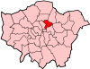
The London Borough of Hackney is a London borough in Inner London, England. The historical and administrative heart of Hackney is Mare Street, which lies 5 miles (8 km) north-east of Charing Cross. The borough is named after Hackney, its principal district. Southern and eastern parts of the borough are popularly regarded as being part of east London that spans some of the traditional East End of London with the northwest belonging to north London. Its population is estimated to be 281,120.

<span class="mw-page-title-main">Dalston</span> Area of East London, England

Dalston is an area of East London, in the London Borough of Hackney. It is four miles northeast of Charing Cross. Dalston began as a hamlet on either side of Dalston Lane, and as the area urbanised the term also came to apply to surrounding areas including Kingsland and Shacklewell, all three of which being part of the Ancient Parish of Hackney.

<span class="mw-page-title-main">North London line</span> Railway line in London

The North London line (NLL) is a railway line which passes through the inner suburbs of west, north-west, north, and north-east London, England between Richmond in the south-west and Stratford in the east, avoiding central London. Its route is a rough semicircle.

<span class="mw-page-title-main">Metropolitan Borough of Hackney</span>

The Metropolitan Borough of Hackney was a metropolitan borough of the County of London from 1900 to 1965. Its area became part of the London Borough of Hackney.

<span class="mw-page-title-main">A10 road (England)</span> Road in England

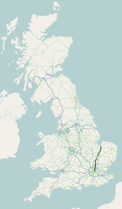
The A10 is a major road in England which runs between The City of London and King's Lynn in Norfolk.

<span class="mw-page-title-main">Dalston Kingsland railway station</span> London Overground station

Dalston Kingsland railway station is a railway station on the North London Line in London, England. It is in the Dalston area of the London Borough of Hackney, on the western side of Kingsland High Street and opposite Ridley Road Market. The station and all trains serving it are operated by London Overground. It is in Travelcard Zone 2. Kingsland railway station was first opened on the site in 1850, but was replaced by Dalston Junction in 1865. The current station was opened by British Rail in 1983. Ticket barriers are in operation. The station straddles the boundary with the London Borough of Islington, with part of the platforms falling within Islington.

<span class="mw-page-title-main">Dalston Junction railway station</span> Railway station in London, England

Dalston Junction is an inter-modal rail and bus transport interchange in Dalston, London. It is located at the crossroads of Dalston Lane, Kingsland Road and Balls Pond Road. The station served by London Overground East London line and is in Zone 2. The station is located in a short section of cut and cover tunnel north of the Kingsland Viaduct.

<span class="mw-page-title-main">Hackney Central</span> Human settlement in England

Hackney Central is a sub-district of Hackney in the London Borough of Hackney in London, England and is four miles (6.4 km) northeast of Charing Cross.

<span class="mw-page-title-main">Kingsland, London</span> Human settlement in England

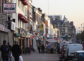
Kingsland was a small road-side settlement centred on Kingsland High Street on the Old North Road, around the junction with Dalston Lane. It is no longer discernable as a separate settlement, though the historic street pattern remains. Since the opening of Dalston Junction station in 1865, the area has become known as Dalston, which was originally a separate hamlet further east. Historically part of the county of Middlesex, the area is within the London Borough of Hackney.

<span class="mw-page-title-main">Hackney (parish)</span>

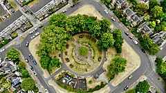
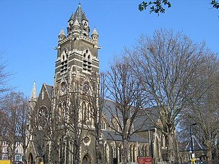
Hackney was a parish in the historic county of Middlesex. The parish church of St John-at-Hackney was built in 1792, replacing the nearby former 16th-century parish church dedicated to St Augustine. The original tower of that church was retained to hold the bells until the new church could be strengthened; the bells were finally removed to the new St John's in 1854. See details of other, more modern, churches within the original parish boundaries below.

<span class="mw-page-title-main">Haggerston railway station</span> London Overground station

Haggerston is a London Overground station in Haggerston, London, England, served by the East London line. It lies between Hoxton and Dalston Junction stations, is in Travelcard Zone 2, and is open 24 hours on a Friday and Saturday as part of the London Overground Night Service service. The station was rebuilt as part of the East London line extension.

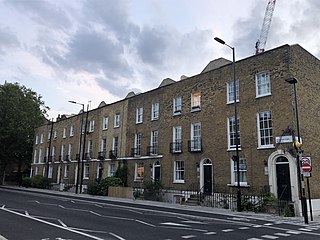
De Beauvoir is a ward encompassing all of De Beauvoir Town and small part of Dalston in the London Borough of Hackney. The ward has existed since the creation of the borough on 1 April 1965 and was first used in the 1964 elections. The boundaries of the ward were revised in 2014.

<span class="mw-page-title-main">London Buses route 277</span> London bus route

London Buses route 277 is a Transport for London contracted bus route in London, England. Running between Cubitt Town and Dalston, it is operated by Stagecoach London.

<span class="mw-page-title-main">Southgate Road</span> Human settlement in England

Southgate Road is a street in London, England, that runs from Baring Street in the south to the junction with Mildmay Park and Ball's Pond Road in the north. The street forms a part of the B102 road, leading from Newington Green to The City. The west side of Southgate Road is in the London Borough of Islington; and the east side is in the London Borough of Hackney. Southgate Road lies north of the Regent's Canal, west of De Beauvoir Town and east of Essex Road.

<span class="mw-page-title-main">Haggerston</span> Human settlement in England

Haggerston is an area in London, England and is located in the London Borough of Hackney. It is in East London and part of the East End. There is an electoral ward called Haggerston within the borough.

<span class="mw-page-title-main">East London line extension</span> Railway engineering project in London

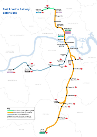
The East London line extension (ELLX) project was a British railway engineering project in London, managed by Transport for London. The project involved extending the East London Line and making it part of the mainline London Overground network. This was done by re-opening sections of disused railway line and by converting track electrified by the third-rail system, signalling, lineside signage and communication systems, etc. to mainline standards. New rolling stock was introduced and four new stations built along the route, with a fifth scheduled to be added in the future at New Bermondsey.

<span class="mw-page-title-main">Angel, London</span> Human settlement in England

Angel is an area on the northern fringes of Central London within the London Borough of Islington. It is 2 miles (3.2 km) north-northeast of Charing Cross on the Inner Ring Road at a busy transport intersection. The area is identified in the London Plan as one of 35 major centres in London. It is a significant commercial and retail centre, and a business improvement district. Angel straddles the ancient boundary of the parishes of Clerkenwell and Islington that later became the metropolitan boroughs of Finsbury and Islington. It is named from the former Angel Inn which stood on the corner of Islington High Street and Pentonville Road. Since 1965 the whole area has formed part of the London Borough of Islington in Greater London.

One Night is a British 2012 drama series broadcast on BBC One, about four people linked by an event in their local area. Classical singer Errollyn Wallen provides the opening and closing theme to each episode with her song "Daedalus".

<span class="mw-page-title-main">Hackney, London</span> Human settlement in England

Hackney is a district in East London, England, forming around two-thirds of the area of the modern London Borough of Hackney, to which it gives its name. It is 4 miles (6.4 km) northeast of Charing Cross and includes part of the Queen Elizabeth Olympic Park. Historically it was within the county of Middlesex.

<span class="mw-page-title-main">William Lyttle</span> Irish eccentric (1931– April 2010)

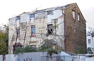
William Lyttle was an Irish eccentric, notable for digging an extensive network of tunnels under his home in De Beauvoir Town, London.

References

  1. Brewers Dictionary of London Phrase and Fable, Chambers Publishing, 20th Ed, 2018
  2. "Meet the craft beer brewer | Behind the scenes". the Guardian. 11 April 2014. Retrieved 25 November 2022.
  3. "De Beauvoir conservation area | Hackney Council". hackney.gov.uk. Retrieved 25 November 2022.
  4. "Kingsland conservation area | Hackney Council". hackney.gov.uk. Retrieved 25 November 2022.
  5. William Rhodes' eldest son, Rev. Francis William Rhodes (1807–1878), was the father of Cecil
  6. http://www.hackney.gov.uk/Assets/Documents/ep-de-beauvoir-appraisal.pdf Archived 24 September 2015 at the Wayback Machine , (De Beauvoir Conservation Area Extension, Conservation Area Appraisa, London Borough of Hackney, 1998)
  7. 1 2 Hackney: De Beauvoir Town, A History of the County of Middlesex: Volume 10: Hackney (1995), pp. 33-35 accessed: 7 March 2009
  8. "De Beauvoir Estate". Emporis .[ dead link ]
  9. Bartholomew, Emma (20 October 2017). "How a tiny Southgate Road chapel played a big role in Russia's 1917 October Revolution". Hackney Gazette.
  10. "Hackney cyclist: The history behind how De Beauvoir Town became a low traffic neighbourhood in the 1970s". Hackney cyclist. 28 October 2015. Retrieved 25 November 2022.
  11. "Sam Smith - Stay With Me (Behind the Scenes Video)". YouTube. Archived from the original on 13 December 2021. Retrieved 8 May 2015.
  12. The Horror and heartache, Karyn Michael, Hackney Today, Issue 158, p.5, 7 May 2007
  13. "The Gentlemen at Lancresse Court - filming location". www.sceen-it.com.
  14. Symondson, Anthony (23 January 1993). "Obituary: Jude Moraes". The Independent. Retrieved 22 May 2021.
  15. After 40 years' burrowing, Mole Man of Hackney is ordered to stop The Guardian
  16. Mole Man faces £100,000 bill for undermining the neighbourhood The Times Online-
  17. Lewis, Paul (18 June 2010). "Hunt for heirs after Hackney 'mole man' William Lyttle dies". The Guardian. London.
  18. "'Mole Man' home in Hackney sold for £1.12m". BBC News. 19 July 2012. Retrieved 19 July 2012.
  19. "David Adjaye renovates Mole House undermined by illegal secret tunnels". Dezeen. 4 February 2020. Retrieved 4 February 2020.
  20. "Hackney Council - Councillor details - Councillor James Peters". mginternet.hackney.gov.uk. 7 September 2019.
  21. "Hackney Council Elections 2018". www.hackney.gov.uk. Archived from the original on 7 May 2018. Retrieved 7 September 2020.
  22. "Hackney Council - Councillor details - Councillor Polly Billington". mginternet.hackney.gov.uk. 7 September 2020.[ permanent dead link ]
  23. "What's happening in De Beauvoir". debeauvoircouncillors.blogspot.co.uk.