
The London Borough of Hackney is a London borough in Inner London. The historical and administrative heart of Hackney is Mare Street, which lies 5 miles (8 km) north-east of Charing Cross. The borough is named after Hackney, its principal district. Southern and eastern parts of the borough are popularly regarded as being part of east London, with the northwest belonging to north London. Its population is 281,120 inhabitants.
Dalston is an area of East London, in the London Borough of Hackney. It is 4 miles (6.4 km) north-east of Charing Cross. Dalston began as a hamlet on either side of Dalston Lane, and as the area urbanised the term also came to apply to surrounding areas including Kingsland and Shacklewell, all three of which being part of the Ancient Parish of Hackney.

Shoreditch is a district in the East End of London that forms the southern part of the London Borough of Hackney. Neighbouring parts of Tower Hamlets are sometimes also perceived as part of the area.

Old Street is a 1-mile (1.6 km) street in inner north-east Central London that runs west to east from Goswell Road in Clerkenwell, in the London Borough of Islington, via St Luke's and Old Street Roundabout, to the crossroads where it meets Shoreditch High Street (south), Kingsland Road (north) and Hackney Road (east) in Shoreditch in the London Borough of Hackney.

The Metropolitan Borough of Hackney was a Metropolitan borough of the County of London from 1900 to 1965. Its area became part of the London Borough of Hackney.

Dalston Kingsland railway station is a railway station on the North London Line in London, England. It is in the Dalston area of the London Borough of Hackney, on the western side of Kingsland High Street and opposite Ridley Road Market. The station and all trains serving it are operated by London Overground. It is in Travelcard Zone 2. Kingsland railway station was first opened on the site in 1850, but was replaced by Dalston Junction in 1865. The current station was opened by British Rail in 1983. Ticket barriers are in operation. The station straddles the boundary with the London Borough of Islington, with part of the platforms falling within Islington.

De Beauvoir Town is a neighbourhood in east London and is in the London Borough of Hackney, 2 miles (3.2 km) north of the City of London. The area was a part of the Hackney; the Ancient Parish and subsequent Metropolitan Borough that was incorporated into the larger modern borough. It is sometimes described as a part of Dalston, which is in turn, also a part of the former parish and borough of Hackney.

Dalston Junction is an inter-modal rail and bus transport interchange in Dalston, London. It is located at the crossroads of Dalston Lane, Kingsland Road and Balls Pond Road. The station served by London Overground East London line and is in Zone 2. The station is located in a short section of cut and cover tunnel north of the Kingsland Viaduct.

Hackney Central is a sub-district of Hackney in the London Borough of Hackney in London, England and is four miles (6.4 km) northeast of Charing Cross.

Shacklewell was a hamlet that developed on Shacklewell Lane in the modern London Borough of Hackney.
Kingsland was a small road-side settlement centred on Kingsland High Street on the Old North Road, around the junction with Dalston Lane. It is no longer discernable as a separate settlement, though the historic street pattern remains. Since the opening of Dalston Junction station in 1865, the area has become known as Dalston, which was originally a separate hamlet further east. Historically part of the county of Middlesex, the area is within the London Borough of Hackney.
The Hackney Brook is one of the subterranean rivers of London. It crossed the northern parts of the current London boroughs of Hackney and Islington, emptying into the River Lea at Old Ford, with its source in Holloway.

Hoxton is a station on the East London line in the London Borough of Hackney, Greater London. It is on the Kingsland Viaduct and served by London Overground. The station entrance is on Geffrye Street near Dunloe Street and Cremer Street, behind the Museum of the Home.
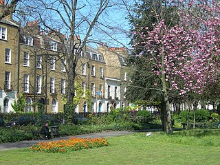
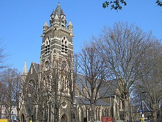
Clapton Square is the second largest garden square in the London Borough of Hackney, located in Lower Clapton, Clapton. It is lined by buildings on three sides. Its Conservation Area designated in 1969 – extended in 1991 and 2000 – takes in a larger green space separated by a stretch of open road: St John's Gardens. Those gardens have the tallest and largest building visible from all parts of the square's garden, the Church of St John-at-Hackney, rebuilt in 1792-97 which contains older monuments. Two sides of the square are lined with tall, partly stone-dressed, classical, Georgian terraced houses.
Kingsland Secondary School was a school located on Shacklewell Lane in the London Borough of Hackney, England. It closed in August 2003.

Southgate Road is a street in London, England, that runs from Baring Street in the south to the junction with Mildmay Park and Ball's Pond Road in the north. The street forms a part of the B102 road, leading from Newington Green to The City. The west side of Southgate Road is in the London Borough of Islington; and the east side is in the London Borough of Hackney. Southgate Road lies north of the Regent's Canal, west of De Beauvoir Town and east of Essex Road.
Kingsland Viaduct is a railway viaduct about 2 miles (3 km) in length, almost wholly within the present London Borough of Hackney in the north-east part of Inner London. It was built in the 1860s, but was disused from 1986 until it was reopened to carry the London Overground in 2010. The viaduct is owned by Transport for London. Since then it has carried East London Line services between Shoreditch High Street and Dalston.

Mare Street is a street in the London Borough of Hackney. It has existed since the 15th century, when it was one of the first roads at the centre of the parish. It was then known as Merestret. The word mere was either the Old English mǣre meaning a boundary — referring to the boundary with the parish of Stepney — or mere, a large pond which was fed by Hackney Brook.

Dalston Square is a complex located just off Kingsland Road near Dalston Junction station in Dalston, part of the London Borough of Hackney, it includes approximately 500 homes, a library, public space, shops and restaurants.

Hackney is a district in East London, England, forming around two-thirds of the area of the modern London Borough of Hackney, to which it gives its name. It is 4 miles (6.4 km) northeast of Charing Cross and includes part of the Queen Elizabeth Olympic Park. Historically it was within the county of Middlesex.
