
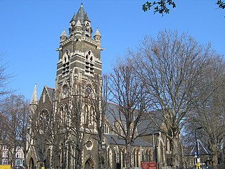
Bethnal Green is an area in London, England, and is located in the London Borough of Tower Hamlets. It is in east London and part of the East End. The area emerged from the small settlement which developed around the Green, much of which survives today as Bethnal Green Gardens, beside Cambridge Heath Road. By the 16th century the term applied to a wider rural area, the Hamlet of Bethnal Green, which subsequently became a Parish, then a Metropolitan Borough before merging with neighbouring areas to become the north-western part of the new Tower Hamlets.

The London Borough of Hackney is a London borough in Inner London, England. The historical and administrative heart of Hackney is Mare Street, which lies 5 miles (8 km) north-east of Charing Cross. The borough is named after Hackney, its principal district. Southern and eastern parts of the borough are popularly regarded as being part of east London that spans some of the traditional East End of London with the northwest belonging to north London. Its population is estimated to be 281,120.
Dalston is an area of East London, in the London Borough of Hackney. It is four miles northeast of Charing Cross. Dalston began as a hamlet on either side of Dalston Lane, and as the area urbanised the term also came to apply to surrounding areas including Kingsland and Shacklewell, all three of which being part of the Ancient Parish of Hackney.

Shoreditch is an area in London, England and is located in the London Borough of Hackney alongside neighbouring parts of Tower Hamlets, which are also perceived as part of the area due to historic ecclesiastical links. Shoreditch lies just north-east of the border with the City of London and is considered to be a part of London's East End.

Stepney is an area in the London Borough of Tower Hamlets in the East End of London. Stepney is no longer officially defined, and is usually used to refer to a relatively small area. However, for much of its history the place name was applied to a much larger manor and parish. Stepney Green is a remnant of a larger area of Common Land formerly known as Mile End Green.

The London Borough of Tower Hamlets is a borough in London, England. Situated on the north bank of the River Thames and immediately east of the City of London, the borough spans much of the traditional East End of London and includes much of the regenerated London Docklands area. The 2019 mid-year population for the borough is estimated at 324,745.

Bethnal Green was a civil parish and a metropolitan borough of the County of London between 1899 and 1965, when it was merged with the Metropolitan Borough of Stepney and the Metropolitan Borough of Poplar to form the London Borough of Tower Hamlets.

East London is the northeastern part of London, England, east of the ancient City of London and north of the River Thames as it begins to widen. East London developed as London's docklands and the primary industrial centre. The expansion of railways in the 19th century encouraged the eastward expansion of the East End of London and a proliferation of new suburbs. The industrial lands of East London are today an area of regeneration, which are well advanced in places such as Canary Wharf and ongoing elsewhere.

The Lea Valley lines are a set of suburban rail lines running along the Lea Valley in East London, North London and Hertfordshire to Liverpool Street and Stratford. Historically part of the Great Eastern Railway, the lines now form part of the Anglia Route of Network Rail. Services are operated by London Overground and Greater Anglia.

Hackney South and Shoreditch is a constituency represented in the House of Commons of the UK Parliament since 2005 by Meg Hillier of Labour Co-op.

The region of Greater London, including the City of London, is divided into 75 parliamentary constituencies which are sub-classified as borough constituencies, affecting the type of electoral officer and level of expenses permitted. Since the general election of July 2024, 59 are represented by Labour MPs, 9 by Conservative MPs, 6 by Liberal Democrat MPs, and 1 by an independent MP.

Cambridge Heath is an area in the London Borough of Tower Hamlets, approximately 5.7 km (3.5 mi) north east of Charing Cross. It is named after a former heath in the East End of London. The northern boundary is formed by the Regent's Canal and the area includes Vyner Street, best known for its street art and galleries.

The London Borough of Hackney, one of the inner London boroughs, has 62 parks, gardens and open spaces within its boundaries, totalling 330 ha. These provide the "green lungs" for leisure activities. Hackney Marshes contain the largest concentration of football pitches in Europe.

Haggerston Park is an open space in Haggerston, in the London Borough of Hackney. It is bounded by Whiston Road, Hackney Road (south) and St Saviour's Priory, Queensbridge Road (west) and Goldsmith's Row (east).

Shoreditch High Street is a station on the Windrush line of the London Overground, located on Bethnal Green Road in Shoreditch, East London. Situated in Travelcard Zone 1, it is located between Whitechapel and Hoxton stations. The station opened on 27 April 2010 as part of the East London line extension, replacing the nearby London Underground station at Shoreditch which closed in 2006.

Hackney North was a parliamentary constituency in "The Metropolis". It returned one Member of Parliament (MP) to the House of Commons of the Parliament of the United Kingdom.

London Buses route 26 is a Transport for London contracted bus route in London, England. Running between Hackney Wick and Victoria station, it is operated by Stagecoach London.

Haggerston is an area in London, England and is located in the London Borough of Hackney. It is in East London and part of the East End. There is an electoral ward called Haggerston within the borough.

Columbia Road Flower Market is a street market in Bethnal Green in London, England. Columbia Road is a road of Victorian shops situated off Hackney Road in the London Borough of Tower Hamlets. The market is open on Sundays only.
Kingsland Viaduct is a railway viaduct about 2 miles (3 km) in length from Shoreditch to Dalston, wholly within the present London Borough of Hackney in east and north-east part of London. It was built in the 1860s, but was disused from 1986 until it was reopened to carry the London Overground in 2010. The viaduct is owned by Transport for London. Since then it has carried East London Line services between Shoreditch High Street and Dalston.
