The Bakerloo line is a London Underground line that runs between Harrow & Wealdstone in suburban north-west London and Elephant & Castle in south London, via the West End. Coloured brown on the Tube map, it serves 25 stations, of which 15 are below ground, over 14.4 miles (23.2 km). It runs partly on the surface and partly at deep level.

The Jubilee line is a London Underground line that runs between Stratford in east London and Stanmore in the suburban north-west, via the Docklands, South Bank and West End. Opened in 1979, it is the newest line on the network, although some sections of track date back to 1932 and some stations to 1879.

The Northern line is a London Underground line that runs from south-west to north-west London, with two branches through central London and three in the north. It runs northwards from its southern terminus at Morden in the borough of Merton to Kennington in Southwark, where it divides into two central branches, one via Charing Cross in the West End and the other via Bank in the City. The central branches re-join at Camden Town where the line again divides into two branches, one to High Barnet and the other to Edgware in the borough of Barnet. On the High Barnet branch there is a short single-track branch to Mill Hill East only.
The London Borough of Brent is a London borough in north west London, and forms part of Outer London. The major areas are Wembley, Kilburn, Willesden, Harlesden and Neasden.

Hampstead was a civil parish and metropolitan borough in London, England. It was an ancient parish in the county of Middlesex, governed by an administrative vestry. The parish was included in the area of responsibility of the Metropolitan Board of Works in 1855 and became part of the County of London in 1889. The parish of Hampstead became a metropolitan borough in 1900, following the London Government Act 1899, with the parish vestry replaced by a borough council. In 1965 the borough was abolished and its former area became part of the London Borough of Camden in Greater London.

Swiss Cottage is a district of the London Borough of Camden in England. It is part of Hampstead and is centred on the junction of Avenue Road and Finchley Road, at the tripoint of the postcodes of Hampstead NW3, Kilburn/West Hampstead NW6 and St Johns Wood NW8. Swiss Cottage is 3.25 miles (5.23 km) north-northwest of Charing Cross. It is the location of Swiss Cottage tube station.

Hampstead & Highgate was a parliamentary constituency covering the northern half of the London Borough of Camden which includes the village of Hampstead and part of that of Highgate.
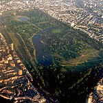
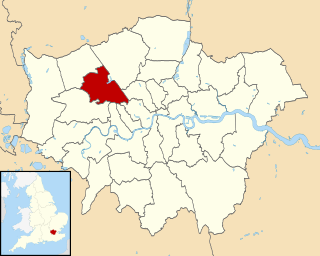
The London Borough of Camden is in percentage terms the second-greenest of the Inner London boroughs. It contains most of the swathe of land Hampstead Heath and many smaller green spaces. The Central London part of the borough, south of Euston Road, is characterised by its elegant garden squares with large instances: Tavistock Square and Bedford Square. In this part runs the Regent's Canal around the top edge of Regent's Park, a little of which is in Camden, including all of associated Primrose Hill. Highgate Cemetery is in Camden but Highgate Wood is in the neighbouring borough of Haringey.

The Jubilee Walkway is an official walking route in London. It was originally opened as the Silver Jubilee Walkway to commemorate Queen Elizabeth II's accession; the Queen herself opened it on 9 June 1977 during her silver jubilee celebrations. The intention was to connect many of London's major tourist attractions and it is now one of seven such walks within the Mayor of London's strategic walking routes. Its length is 15 miles.

Hampstead and Kilburn is a constituency created in 2010 and currently represented in the House of Commons by Tulip Siddiq of the Labour Party. Glenda Jackson was the MP from 2010–2015, having served for the predecessor seat since 1992.

Coram's Fields is a large urban open space in the London borough of Camden in central London. It occupies seven acres in Bloomsbury and includes a children's playground, sand pits, a duck pond, a pets corner, café and nursery. Adults are only permitted to enter if accompanied by children.

Grangewood Park is an extensive woodland area situated in South Norwood, London. It is managed by the London Borough of Croydon. It is bounded by Grange Road, Wharncliffe Road, and Ross Road. It covers an area of 273⁄4 acres 11.23 hectares. The park is located on the main A212 road between Thornton Heath and Upper Norwood/Crystal Palace. The nearest stations are Thornton Heath, Selhurst and Norwood Junction.
Bloomsbury is a ward in the London Borough of Camden, in the United Kingdom. The ward has existed since the creation of the borough on 1 April 1965 and was first used in the 1964 elections.

The London Irish Centre is a charity based in Camden, London, which has served the Irish community for over sixty years.
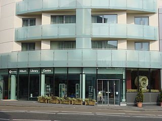
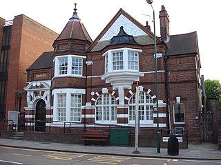
There are two library buildings in North London called Kilburn Library. One is in the London Borough of Camden and located in the Kilburn High Road, NW6, and the other is in the London Borough of Brent and located in Salusbury Road. NW6.

Belsize Wood is a 0.7 hectare Local Nature Reserve and a Site of Borough Importance for Nature Conservation, Grade II, in Belsize Park in the London Borough of Camden. It is a steeply sloping site divided into a northern half, which is always open to the public and is of lesser ecological value, and a southern part which is in a better state of conservation, and which is only open at weekends. The two halves are separated by a public footpath between Lawn Road and Aspern Grove. The site is owned and managed by Camden Council.

Greville Place is a 0.12 hectare nature reserve in Kilburn in the London Borough of Camden. It is a Site of Local Importance for Nature Conservation, and it is managed by the London Wildlife Trust.