River Tyburn

Last updated

LondonBeforeHouses.jpg
Extract from London Before the Houses, W.E. Loftie, 1884 showing at centre the brook, it ran east of the elevated key crossroads marked by the Tyburn Tree and Ossulstone (Oswald's Stone); today by Marble Arch.

The River Tyburn was a stream (bourn) in London, England. Its main successor sewers emulate its main courses, but it resembled the Colne in its county of Middlesex in that it had many distributaries (inland mouths). It ran from South Hampstead, through Marylebone, Mayfair, St James's parish/district and Green Park to meet the tidal Thames at four sites, grouped into pairs. These pairs were near Whitehall Stairs (east of Downing Street), and by Thorney Street, between Millbank Tower and Thames House. Its much smaller cousin, the Tyburn Brook, was a tributary of the Westbourne and the next Thames tributary (west, on the north bank).

Contents

Name

A charter of AD 959 appears to mention the river, which it refers to as Merfleot, which probably translates as Boundary Stream, a suggestion reinforced by context, with the river forming the western boundary of the estate described. [1] It is also mentioned in Edgar's Charter, dating from AD 951, where it is rendered as Teo-burna, a name which is thought to mean "two-burn". This may refer to the two branches of the Tyburn which passed through Marylebone and converged to the north of Oxford Street. Ekwall, writing in 1928, suggested that the name meant boundary stream as it followed a course between Lilestone manor and Tyburn manor, but this is now questioned, as both of the river banks were in Tyburn manor. [2]

The Tyburn is also known as the Aye and the Kings Scholars Pond Sewer, [3] though it has to be remembered that the word "sewer" originally referred to an open channel used for the drainage of surface water, and it was illegal to pollute them with offensive material prior to 1815. [4]

Course

Before it was culverted then used as a sewer, this 7-mile (11 km) brook rose from the confluence of two streams in the hills of South Hampstead, deriving from the broad ravine between Barrow and Primrose Hills. Its main source was the Shepherd's Well near Fitzjohn's Avenue, Hampstead. [5] At Green Park, the waters split into distributaries, creating Thorney Island on which Westminster Abbey was built. [6] As the map shows, these again split in two, one in the then lower, thus typically Spring tide immersed bank, where Whitehall sits, the other close to Vincent Square, Pimlico, Westminster. The river's current path is fully enclosed by concrete, bricks, parks and roads, flowing through underground conduits for its entire length, including one beneath Buckingham Palace. [6] Several streets, including Marylebone Lane, Jason Court, Gees Court, South Molton Lane then Bruton Lane, defy the grid system of streets as the streets follow the former path of the Tyburn on what was its left bank through Marylebone village. [7] Most of its catchment drains into soakaways in gravel soil, in turn into the chalk water table beneath or into the two-type and hybrid type of drainage set out in Victorian London. In the Tyburn's depression run key (lateral) sewers which connect to Bazalgette's west-to-east Interceptor sewers. [6]

From its source at the Shepherd's Well near Fitzjohns Avenue in Hampstead its successor is Scholar's Pond Sewer southward along that avenue through the Swiss Cottage part of South Hampstead under Avenue Road to Regent's Park. To enter the park's perimeter the part-foul (combined) run is carried enpiped over the Regent's Canal then culverted. [7]

The Tyburn gave its name to the former area of Tyburn, a manor of Marylebone, which was recorded in Domesday Book and which stood approximately at the west end of what is now Oxford Street, where from late medieval times until the 18th century traitors were left following hanging at Tyburn Gallows. Tyburn gave its name to the predecessors of Oxford Street and Park Lane—Tyburn Road and Tyburn Lane, respectively.

An antiques shop claims that part of the river flows through an open conduit in its basement. Rivertyburn.JPG
An antiques shop claims that part of the river flows through an open conduit in its basement.

Grays Antique Centre near the junction of Oxford Street and Davies Street claims that the body of water which can be seen in an open conduit in the basement of its premises is part of the Tyburn; [8] [9] it is undoubtedly close to the culverted course of the stream. The Londonist website describes this suggestion as "fanciful", as the modern Tyburn is a sewer. [10]

The stream's southward route followed Lansdowne Row, the north-east of Curzon Street then White Horse Street and the pedestrian avenue of Green Park to the front gates of Buckingham Palace (foot of Constitution Hill) from where one mouth used the depression of St James's Park Lake and Downing Street to reach two close-paired mouths. A third distributary is untraced in the building lines and street layout to Thorney Street close to Lambeth Bridge, [6] whilst a fourth distributary forms the natural collect for a 3-metre (9.8 ft) sewer pipe, King's Scholar's Pond Sewer, to the Victoria Embankment interceptor, saving it from discharging west of Vauxhall Bridge.

Maintenance

The Kings Scholars Pond Sewer was constructed between 1848 and 1856. When the Metropolitan Line was constructed in the early 1860s, it used cut and cover techniques to excavate the tunnels for the underground railway. At Baker Street station, the railway passed beneath the Kings Scholars Pond Sewer, which was supported by a bridge structure attached to the side walls of the tunnel. By the late 2010s, the bridge and sewer had settled below their original level by 6.5 inches (166 mm), and were encroaching on the space needed by the trains. Thames Water, who own the sewer, looked at ways to rectify the problem. [11] Three options were considered. The first involved replacing the bridge and strengthening the walls of the tunnel, but this would have involved closing the railway for three months, at a cost of some £30 million, in addition to the cost of the work. Above the sewer there were reinforced concrete slabs, thought to have been installed during the Second World War, and the second option was to hang a new structure from these. However, further investigation showed that the slabs were not sufficiently robust for this to be safe. [12]

The solution adopted was to construct a Vierendeel truss within the existing sewer, fitted with a glass fibre reinforced plastic (GFRP) liner. The entire structure was made of small modular parts, which could be fitted through a 24-by-30-inch (600 by 750 mm) access hole. When assembled, the structure would be longer than the railway tunnel width, so that its ends were supported by ground beyond the tunnel walls. Once all the components had been manufactured, installation work began in June 2018, and continued until October 2018. The scheme was managed by a joint venture comprising Skanska, MWH Treatment, and Balfour Beatty (SMB JV), with Stantec UK Ltd as a designer and McAllister Group carrying out the on-site work. The steel truss is expected to last for 120 years without maintenance, while the GFRP liner has a life span of 50 years. [12] The innovative nature of the solution resulted in the project being given a commendation by the Institution of Structural Engineers in 2021. [13]

See also

Related Research Articles

<span class="mw-page-title-main">Subterranean rivers of London</span> Geographical feature of England

The subterranean or underground rivers of London are or were the direct or indirect tributaries of the upper estuary of the Thames that were built over during the growth of the metropolis of London. They now flow through culverts, with some of them integral parts of London's sewerage system and diverted accordingly.

Subterranean London refers to a number of subterranean structures that lie beneath London. The city has been occupied by humans for two millennia. Over time, the capital has acquired a vast number of these structures and spaces, often as a result of war and conflict.

<span class="mw-page-title-main">River Fleet</span> Subterranean river in London, England

The River Fleet is the largest of London's subterranean rivers, all of which today contain foul water for treatment. It has been used as a sewer since the development of Joseph Bazalgette's London sewer system in the mid-19th century with the water being treated at Beckton Sewage Treatment Works. Its headwaters are two streams on Hampstead Heath, each of which was dammed into a series of ponds—the Hampstead Ponds and the Highgate Ponds—in the 18th century. At the southern edge of Hampstead Heath these descend underground as sewers and join in Camden Town. The waters flow 4 miles (6 km) from the ponds.

<span class="mw-page-title-main">River Effra</span> River in England

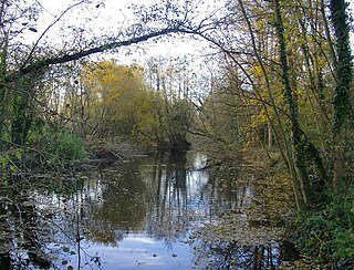
The River Effra is a former set of streams in south London, England, culverted and used mainly for storm sewerage. It had been a tributary of the Thames. Its catchment waters, where not drained to aquifer soakaways and surface water drains, have been incorporated into 1850s-built combined sewer sectors, devised by Sir Joseph Bazalgette. One drains Peckham, the other Brixton, then intended to flow towards Peckham. These generally flow east to be treated at Crossness.
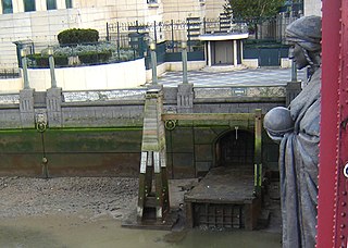
<span class="mw-page-title-main">River Westbourne</span> River in London, England

The Westbourne or Kilburn is a culverted small River Thames tributary in London, rising in Hampstead and Brondesbury Park and which as a drain unites and flows southward through Kilburn and Bayswater to skirt underneath the east of Hyde Park's Serpentine lake then through central Chelsea under Sloane Square. It passes centrally under the south side of Royal Hospital Chelsea's Ranelagh Gardens before discharging into Inner London's old-fashioned, but grandiose combined sewer system, with exceptional discharges into the Inner London Tideway. Since the latter 19th century, the population of its catchment has risen further but to reduce the toll it places on the Beckton Sewage Treatment Works and related bills its narrow basin has been assisted by private soakaways, and public surface water drains. Its depression has been replaced with and adopted as a reliable route for a gravity combined sewer. The formation of the Serpentine relied on the water, a lake with a long, ornate footbridge and various activities associated, which today uses little-polluted water from a great depth.

<span class="mw-page-title-main">River Wandle</span> Tributary of the River Thames, England

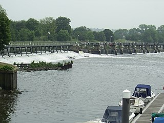
The River Wandle is a right-bank tributary of the River Thames in south London, England. With a total length of about 9 miles (14 km), the river passes through the London boroughs of Croydon, Sutton, Merton and Wandsworth, where it reaches the Thames. A short headwater – the Caterham Bourne – is partially in Surrey, the historic county of the river's catchment. Tributaries of the Wandle include Carshalton Ponds and Norbury Brook.

<span class="mw-page-title-main">River Colne, Hertfordshire</span> River in south England

The Colne is a river and a tributary of the River Thames in England. Just over half its course is in south Hertfordshire. Downstream, it forms the boundary between Buckinghamshire and the London Borough of Hillingdon. The confluence with the River Thames is on the Staines reach at Staines-upon-Thames.

<span class="mw-page-title-main">Northern Outfall Sewer</span> Sewer in London

The Northern Outfall Sewer (NOS) is a major gravity sewer which runs from Wick Lane in Hackney to the Beckton Sewage Treatment Works in east London. Most of it was designed by Joseph Bazalgette, as a result of an outbreak of cholera in 1853 and the "Great Stink" of 1858.

<span class="mw-page-title-main">Tyburn Brook</span> Former stream in London, England

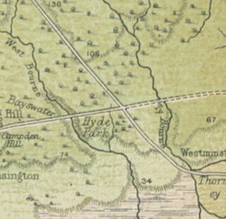
Tyburn Brook was a small tributary stream to the West Bourne or Westbourne and ran mainly in Hyde Park for a few hundred metres south by south-west. It has lost its catchment to natural drainage into the gravelly topsoil and to surface water, foul and in early Victorian style combined sewers and its small collect, its source remains beneath the earth to feed into a mixture of these. The Serpentine, having been the Westbourne's main showing is now fed by three boreholes instead. It is not to be confused with the much longer Tyburn, Ty Bourne or River Tyburn, but frequently was confused until the early 19th century as both were well west of the walls of the City of London.

<span class="mw-page-title-main">Stamford Brook</span> Subterranean river in London, England

Stamford Brook was a tributary of the Tideway stretch of the River Thames in west London supplied by three headwaters. Historically used as an irrigation ditch or dyke, the network of small watercourses had four lower courses and mouths.

<span class="mw-page-title-main">Counter's Creek</span> Culverted stream in west London

Counter's Creek, ending in Chelsea Creek, the lowest part of which still exists, was a stream that flowed from Kensal Green, by North Kensington and flowed south into the River Thames on the Tideway at Sands End, Fulham. Its remaining open watercourse is the quay of Chelsea Creek.

<span class="mw-page-title-main">River Crane, London</span> River in England

The River Crane, a tributary of the River Thames, runs 8.5 miles (13.6 km) in West London, England. It forms the lower course of Yeading Brook. It adjoins or passes through three London boroughs: Hillingdon, Hounslow and Richmond upon Thames, in the historic county of Middlesex. The drainage basin is heavily urbanised but many of the Hayes to Whitton flood-meadows have been conserved, forming a narrow, green vale, opening out to what remains of Hounslow Heath in the centre – a near-continuous belt of semi-natural habitat.

<span class="mw-page-title-main">River Ash, Surrey</span> River in Surrey, England

The River Ash is a small, shallow river in Surrey, England. Its course of 10 kilometres (6.2 mi) is just outside Greater London. Work has been carried out to re-align, clear and build up a small, Littleton head of water and create two backwaters. One backwater dates to the medieval period; the other to the 1990s. It flows as one of the six distributaries of the River Colne from the south of Staines Moor immediately south of the Staines Bypass eastwards through the rest of the borough of Spelthorne before meeting the River Thames.
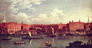
<span class="mw-page-title-main">Falconbrook</span> Covered river in London, England

The Falconbrook was a stream that rose in Balham and Tooting, draining much of those parishes then the south and west of the larger district of Battersea including Clapham Junction to enter the London reaches of the Thames. Before doing so, it briefly formed the border of Wandsworth Town, reflected in the SW11/SW18 boundary today.

<span class="mw-page-title-main">Marylebone</span> Area in London, England

Marylebone is an area in London, England and is located in the City of Westminster. It is in Central London and part of the West End. Oxford Street forms its southern boundary.

<span class="mw-page-title-main">Minetta Creek</span> Buried stream in Manhattan, New York

Minetta Creek was one of the largest natural watercourses in Manhattan, New York City, United States. Minetta Creek was fed from two tributaries, one originating at Fifth Avenue and 21st Street, and the other originating at Sixth Avenue and 16th Street. They joined near Fifth Avenue and 11th Street then took a southwesterly course. Minetta Creek's name is thought to have originated from either the Native American term "Manette", meaning "Devil's Water", or the Dutch word "Minnetje", meaning "the little one".

<span class="mw-page-title-main">Sudbrook (stream)</span> River in England

Sudbrook and its tributary, the Latchmere stream, are north-flowing streams in London, England, that drain northern Kingston upon Thames and the eastern extreme of Ham following a meander scar in a terrace; the upper part of the Sudbrook drains a narrow vale in Richmond Park's southern corner into the tidal Thames.

<span class="mw-page-title-main">Eia</span> Former Medieval manor in Middlesex, England

Eia or Eye was an early Medieval manor in Westminster, Middlesex and is now a part of Central London. It was about one mile west of the Palace of Westminster/Whitehall, about 2 miles west-south-west of the walled City of London, and about half a mile north of the River Thames.

<span class="mw-page-title-main">Marylebone Lane</span>

Marylebone Lane is one of the original streets of the Marylebone district of the City of Westminster, London. It runs from Oxford Street in the south to Marylebone High Street in the north, its winding shape following the course of the River Tyburn that it once ran alongside and pre-dating the grid pattern of the other streets in the area. Today the lane is largely composed of small shops, cafes and restaurants with some small apartment blocks. There are some larger commercial buildings at the southern end near Oxford Street.

References

  1. Naismith 2019, pp. 131–132.
  2. Barton & Myers 2016, p. 54.
  3. Halliday 2008, p. 26.
  4. Halliday 2008, pp. 28–29.
  5. Clayton, Antony (2000). Subterranean City: Beneath the Streets of London. London: Historical Publications. p. 33. ISBN   978-0-948667-69-5.
  6. 1 2 3 4 "Illustrations 1, 4 and the webpage of the Walbrook River page - a synopsis". Archived from the original on 4 October 2013. It cites these books:
    The Lost Rivers of London Nicholas Barton (1962)
    Subterranean City Anthony Clayton (2000)
    London Beneath the Pavement Michael Harrison (1961)
    Springs, Streams, and Spas of London Alfred Stanley Foord (1910)
    J. G. White, History of The Ward of Walbrook. (1904)
    Andrew Duncan, Secret London. (6th Edition, 2009)
  7. 1 2 Barton, Nicholas (1962). The lost rivers of London: a study of their effects upon London and Londoners, and the effects of London and Londoners upon them. Historical Publications. ISBN   978-0-948667-15-2.
  8. "Grays: The Lost River Tyburn". 2008. Archived from the original on 8 November 2020. Retrieved 18 June 2010.
  9. "Silent UK – Urban Exploration: River Tyburn". SilentUK.com. 2009. Archived from the original on 3 June 2013. Retrieved 24 August 2016.
  10. "How To Catch A Glimpse Of The Lost River Tyburn". Londonist. 3 July 2019. Archived from the original on 2 July 2022. Retrieved 28 October 2019.
  11. "King's Scholars Pond Sewer Rehabilitation". Stantec. 2019.
  12. 1 2 Hanfi & Edwards 2018.
  13. "King's Scholars Pond Sewer Rehabilitation". Institution of Structural Engineers. 2023. Archived from the original on 30 September 2022.

Bibliography

Next confluence upstream River Thames Next confluence downstream
River Westbourne (north or left bank)River Tyburn River Effra (south or right bank)

51°30′49″N0°08′55″W / 51.5136°N 0.1486°W / 51.5136; -0.1486