
Tyburn was a village in the county of Middlesex close to the current location of Marble Arch and the southern end of Edgware Road in present-day London. It took its name from the Tyburn Brook, a tributary of the River Westbourne. The name Tyburn, from Teo Bourne meaning 'boundary stream', is quite widely occurring, and the Tyburn Brook should not be confused with the better known River Tyburn, which is the next tributary of the River Thames to the east of the Westbourne.

Marylebone Road is an important thoroughfare in central London, within the City of Westminster. It runs east-west from the Euston Road at Regent's Park to the A40 Westway at Paddington. The road which runs in 3 lanes in both directions, is part of the London Inner Ring Road and as such forms part of the boundary of the zone within which the London congestion charge applies.

Kensington Gardens, once the private gardens of Kensington Palace, are among the Royal Parks of London. The gardens are shared by the City of Westminster and the Royal Borough of Kensington and Chelsea and sit immediately to the west of Hyde Park, in western central London. The gardens cover an area of 270 acres. The open spaces of Kensington Gardens, Hyde Park, Green Park, and St. James's Park together form an almost continuous "green lung" in the heart of London. Kensington Gardens are Grade I listed on the Register of Historic Parks and Gardens.

The Serpentine is a 40-acre (16 ha) recreational lake in Hyde Park, London, England, created in 1730 at the behest of Queen Caroline. Although it is common to refer to the entire body of water as the Serpentine, strictly the name refers only to the eastern half of the lake. Serpentine Bridge, which marks the boundary between Hyde Park and Kensington Gardens, also marks the Serpentine's western boundary; the long and narrow western half of the lake is known as the Long Water. The Serpentine takes its name from its snakelike, curving shape, although it only has one bend.

The Westbourne or Kilburn is a mainly re-diverted small River Thames tributary in London, rising in Hampstead and which, notwithstanding one main meander, flows southward through Kilburn and the Bayswater to skirt underneath the east of Hyde Park's Serpentine lake then through central Chelsea under Sloane Square and it passes centrally under the south side of Royal Hospital Chelsea's Ranelagh Gardens before historically discharging into the Inner London Tideway. Since the latter 19th century its narrow basin has been further narrowed by corollary surface water drains and its main flow has been replaced with a combined sewer beneath its route.

The River Wandle is a tributary of the River Thames in south London, England. With a total length of about 9 miles (14 km), the river passes through the London Boroughs of Croydon, Sutton, Merton, to meet the Thames at Wandsworth. A short headwater - the Caterham Bourne - is in Surrey, the historic county of the river's catchment. Other tributaries of the Wandle include the River Wrythe and the Norbury Brook.

The Colne is a river in England which is a tributary of the River Thames. Just over half its course is in south Hertfordshire. Downstream, the Colne is the boundary between Buckinghamshire and London and finally between corners of Berkshire and Surrey. On leaving Hertfordshire, the watercourse splits off into several separate branches, a few of which rejoin it, and its main branch flows into the River Thames on the reach above Penton Hook Lock at Staines-upon-Thames.
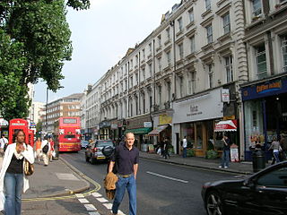
Westbourne Grove is a retail road running across Notting Hill, in the Royal Borough of Kensington and Chelsea and the City of Westminster, a section of west London. It runs from Kensington Park Road in the west to Queensway in the east, crossing over Portobello Road. It contains a mixture of independent and chain retailers, and has been termed both "fashionable" and "up-and-coming".

Queensway is a bustling cosmopolitan street in Bayswater, an area of west London. It is home to Whiteleys, many restaurants, cafés, pubs, souvenir shops and a few high-street retail chains. Queensway and Westbourne Grove are identified in the London Plan as one of 35 major centres in Greater London. The street is numbered the B411 in the British road numbering scheme.

The River Tyburn was a stream (bourn) in London, its main successor sewers emulate its main courses but it resembled the Colne in its county of Middlesex in that it had many distributaries. It ran from South Hampstead, through Marylebone and Soho then ran through St James's parish/district and Green Park to meet the tidal Thames at four sites, grouped into pairs. These pairs were near Whitehall Stairs and by Thorney Street, between Millbank Tower and Thames House. Its much smaller cousin the Tyburn Brook was a tributary of the Westbourne, in turn the next Thames tributary.
Tyburn may refer to the following places in England:

Brook Street is an axial street in the exclusive central London district of Mayfair. Most of it is leasehold, paying ground rent to and seeking lease renewals from the reversioner, that since before 1800, has been the Grosvenor Estate. Named after the Tyburn that it crossed, it was developed in the first half of the 18th century and runs from Hanover Square to Grosvenor Square. The western continuation is called Upper Brook Street; its west end faces Brook Street Gate of Hyde Park. Both sections consisted of neo-classical terraced houses, mostly built to individual designs. Some of them were very ornate, finely stuccoed and tall-ceilinged, designed by well known architects for wealthy tenants, especially near Grosvenor Square, others exposed good quality brickwork or bore fewer expensive window openings and embellishments. Some of both types survive. Others have been replaced by buildings from later periods.

Westbourne is a village, civil parish and electoral ward in the Chichester District of West Sussex, England. It is located 0.5 miles (0.80 km) north east of Emsworth. The parish includes the hamlets of Woodmancote and Aldsworth, and once included the settlements of Southbourne and Prinsted to the south. The village stands on the River Ems, a small river flowing into Chichester Harbour at Emsworth. It is believed that the village takes its name from its position on the river, which traditionally marks the westernmost boundary of Sussex, bourne being an archaic term for a boundary as well as for a small river or brook.
Westbourne is an area west of Paddington in west London. It has a manorial history spanning many centuries, within a more broadly defined Paddington, before shedding its association in the mid-19th century. It is named after the west bourne, West Bourne, or River Westbourne, a Thames tributary which was encased in 19th-century London in the 1850s. The spring-fed stream and associated manor have led to the place names Westbourne Green, Westbourne Park and more narrowly: Westbourne Gardens, Westbourne Grove, Westbourne Park Road, Westbourne Park tube station, Westbourne Studios and the name of a public house.

Westbourne Green is an area of Westbourne, London, the centre of the former hamlet of Westbourne, at the north-western corner of the City of Westminster. It is named for its location west of a bourne.

The River Bourne or the Chertsey Bourne is in Berkshire and Surrey; it runs from sources in Windsor Great Park and Swinley Forest through to the River Thames.

The River Bourne is the name given to a Thames tributary in northwest Surrey, England which has a longer tributary, the Windle Brook, that rises nears Bagshot Park in the south of Swinley Forest, Berkshire, merging with it while flowing through villages north of Woking; downstream the Bourne joins the Thames near Weybridge.

Pymmes Brook is located in North London and named after William Pymme, a local land owner. It is a minor tributary of the River Lea. The brook mostly flows through urban areas and is particularly prone to flooding in its lower reaches. To alleviate the problem the brook has been culverted in many areas. Part of it is a Site of Borough Importance for Nature Conservation, Grade II.

Eia or Eye was an early Medieval manor in the parish of Westminster, Middlesex and is now a part of Central London It was about one mile west of the Palace of Westminster/Whitehall, about 2 miles west-south-west of the walled City of London, and about half a mile north of the River Thames. A smaller sub-manor called Ebury or Eybury, containing the hamlet Eye Cross, was originally part of the manor. Ebury and a corruption of it, Avery, appear as modern streets and other places.
