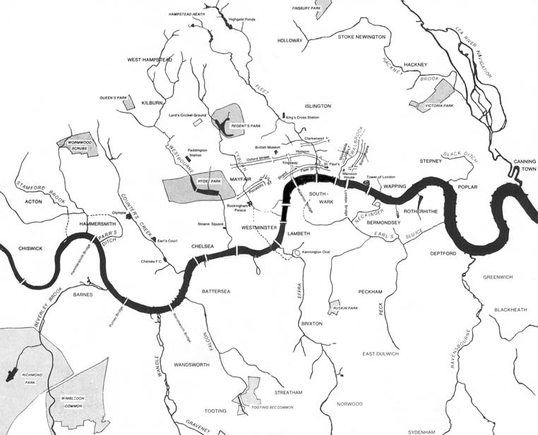
The subterranean or underground rivers of London are or were the direct or indirect tributaries of the upper estuary of the Thames (the Tideway) that were built over during the growth of the metropolis of London. They now flow through culverts, [2] with some of them integral parts of London's sewerage system and diverted accordingly. [3]
From west to east - sub-tributaries are shown indented
In June 2008, the office of Mayor of London published outline plans to reinstate some underground rivers. [7] In January 2009, a partnership among the Environment Agency, Natural England, The River Restoration Centre, and the Greater London Authority set out a strategy for putting this into effect by creating the London Rivers Action Plan. [8] [9]
Subterranean London refers to a number of subterranean structures that lie beneath London. The city has been occupied by humans for two millennia. Over time, the capital has acquired a vast number of these structures and spaces, often as a result of war and conflict.
The River Fleet is the largest of London's subterranean rivers, all of which today contain foul water for treatment. It has been used as a sewer since the development of Joseph Bazalgette's London sewer system in the mid-19th century with the water being treated at Beckton Sewage Treatment Works. Its headwaters are two streams on Hampstead Heath, each of which was dammed into a series of ponds—the Hampstead Ponds and the Highgate Ponds—in the 18th century. At the southern edge of Hampstead Heath these descend underground as sewers and join in Camden Town. The waters flow 4 miles (6 km) from the ponds.
The River Churn is a tributary of the River Thames in central England. It rises at Seven Springs in Gloucestershire and flows south for approximately 37.3 km (23.2 mi) to meet the Thames at Cricklade in Wiltshire. Its length from its source to the confluence with the Thames is greater than that of the Thames from Thames Head, but the Churn is regarded as a tributary, rather than the main river.
The River Wandle is a right-bank tributary of the River Thames in south London, England. With a total length of about 9 miles (14 km), the river passes through the London boroughs of Croydon, Sutton, Merton and Wandsworth, where it reaches the Thames. A short headwater – the Caterham Bourne – is partially in Surrey, the historic county of the river's catchment. Tributaries of the Wandle include Carshalton Ponds and Norbury Brook.
The River Brent is a river in west and northwest London, England, and a tributary of the River Thames. 17.9 miles (28.8 km) in length, it rises in the Borough of Barnet and flows in a generally south-west direction before joining the Tideway stretch of the Thames at Brentford.
Tyburn Brook was a small tributary stream to the West Bourne or Westbourne and ran mainly in Hyde Park for a few hundred metres south by south-west. It has lost its catchment to natural drainage into the gravelly topsoil and to surface water, foul and in early Victorian style combined sewers and its small collect, its source remains beneath the earth to feed into a mixture of these. The Serpentine, having been the Westbourne's main showing is now fed by three boreholes instead. It is not to be confused with the much longer Tyburn, Ty Bourne or River Tyburn, but frequently was confused until the early 19th century as both were well west of the walls of the City of London.
The River Tyburn was a stream in London, England. Its main successor sewers emulate its main courses, but it resembled the Colne in its county of Middlesex in that it had many distributaries. It ran from South Hampstead, through Marylebone, Mayfair, St James's parish/district and Green Park to meet the tidal Thames at four sites, grouped into pairs. These pairs were near Whitehall Stairs, and by Thorney Street, between Millbank Tower and Thames House. Its much smaller cousin, the Tyburn Brook, was a tributary of the Westbourne and the next Thames tributary.
Stamford Brook was a tributary of the Tideway stretch of the River Thames in west London supplied by three headwaters. Historically used as an irrigation ditch or dyke, the network of small watercourses had four lower courses and mouths.
London is the largest urban area and capital city of the United Kingdom. It is located in the southeast of Great Britain. The London region covers an area of 1,579 square kilometres (610 sq mi), and had a population of 8.982 million in 2019 and a population density of 5,596 people per square km as of 2021. A larger area, referred to as the London Metropolitan Region or the London Metropolitan Agglomeration covers an area of 8,382 square kilometres (3,236 sq mi), and had a population of 12,653,500 and a population density of 1,510 people per square kilometre.
The River Crane, a tributary of the River Thames, runs 8.5 miles (13.6 km) in West London, England. It forms the lower course of Yeading Brook. It adjoins or passes through three London boroughs: Hillingdon, Hounslow and Richmond upon Thames, in the historic county of Middlesex. The drainage basin is heavily urbanised but many of the Hayes to Whitton flood-meadows have been conserved, forming a narrow, green vale, opening out to what remains of Hounslow Heath in the centre – a near-continuous belt of semi-natural habitat.
The Hackney Brook is one of the subterranean rivers of London. Rising in Holloway, it crossed the northern parts of the current London boroughs of Islington and Hackney, before emptying into the River Lea at Old Ford.
The Tideway is a part of the River Thames in England which is subject to tides. This stretch of water is downstream from Teddington Lock. The Tideway comprises the upper Thames Estuary including the Pool of London.
The River Ching is a tributary of the River Lea, flowing from Epping Forest, in southeast England.
Turkey Brook is a river in the northern outskirts of London. It rises in Potters Bar, Hertfordshire, and flows broadly eastwards to merge with the River Lea Navigation near Enfield Lock.
Pymmes Brook is located in North London and named after William Pymme, a local land owner. It is a minor tributary of the River Lea. The brook mostly flows through urban areas and is particularly prone to flooding in its lower reaches. To alleviate the problem the brook has been culverted in many areas. Part of it is a Site of Borough Importance for Nature Conservation, Grade II.
Salmons Brook is a minor tributary of the River Lea, located in the London Borough of Enfield.
The Falconbrook was a stream that rose in Balham and Tooting, draining much of those parishes then the south and west of the larger district of Battersea including Clapham Junction to enter the London reaches of the Thames. Before doing so, it briefly formed the border of Wandsworth Town, reflected in the SW11/SW18 boundary today.
Cuffley Brook is a tributary of Turkey Brook. It runs through parts of Hertfordshire and the London Borough of Enfield, England. After the confluence of the two streams in Whitewebbs Park, the watercourse continues eastwards as Turkey Brook to join the River Lea near Enfield Lock.
{{cite book}}
: CS1 maint: unfit URL (link){{cite news}}
: CS1 maint: bot: original URL status unknown (link){{cite web}}
: CS1 maint: bot: original URL status unknown (link)