Related Research Articles

The mayor of London is the executive of the Greater London Authority. The current mayor is Sadiq Khan, who took up office on 9 May 2016. The position was held by Ken Livingstone from the creation of the role on 4 May 2000, until he was defeated in May 2008 by Boris Johnson, who served two terms before being succeeded by Khan.

The Greater London Authority (GLA), also known as City Hall, is the devolved regional governance body of London, with jurisdiction over both counties of Greater London and the City of London. It consists of two political branches: the executive Mayoralty and the 25-member London Assembly, which serves as a means of checks and balances on the former. Since May 2016, both branches have been under the control of the London Labour Party. The authority was established in 2000, following a local referendum, and derives most of its powers from the Greater London Authority Act 1999 and the Greater London Authority Act 2007.

The metropolitan counties are a type of county-level administrative division of England. There are six metropolitan counties, which each cover large urban areas, with populations between 1 and 3 million. They were created in 1974 and are each divided into several metropolitan districts or boroughs.

The subterranean or underground rivers of London are the tributaries of the River Thames and River Lea that were built over during the growth of the metropolis of London. The rivers now flow through underground culverts, with a number of them now integral parts of London's sewerage system.

British Waterways, often shortened to BW, was a statutory corporation wholly owned by the government of the United Kingdom. It served as the navigation authority for the majority of canals and a number of rivers and docks in England, Scotland and Wales.

Water transport played a vital role in the United Kingdom's industrial development. The beginning of the 19th century saw a move from roads to waterways,.

The Thames and Severn Canal is a canal in Gloucestershire in the south of England, which was completed in 1789. It was conceived as part of a canal route from Bristol to London. At its eastern end, it connects to the River Thames at Inglesham Lock near Lechlade, while at its western end, it connects to the Stroudwater Navigation at Wallbridge near Stroud, and thence to the River Severn. It has one short arm (branch), from Siddington to the town of Cirencester. It includes Sapperton Tunnel, which when built was the longest canal tunnel in Britain, and remains the second longest complete tunnel. There were always problems with water supply, as no reservoirs were built, while the summit section near the tunnel ran through porous limestone, and there were constant difficulties with leakage. Competition from the railways took much of the canal's traffic by the end of the 19th century, and most of the canal was abandoned in 1927, the remainder in 1941.

The British canal system of water transport played a vital role in the United Kingdom's Industrial Revolution at a time when roads were only just emerging from the medieval mud and long trains of packhorses were the only means of "mass" transit by road of raw materials and finished products. The UK was the first country to develop a nationwide canal network.

South London is the southern part of London, England. Situated south of the River Thames, it includes the historic districts of Southwark, Lambeth, Bankside and Greenwich.

North London is an informally and inexactly defined part of London, England, which covers some of the area of the capital lying north of the River Thames. It extends from Clerkenwell and Finsbury on the edge of the City of London financial district, to Greater London's boundary with Hertfordshire.
The River Ingrebourne is a tributary of the River Thames 27 miles (43.3 km) in length. It is considered a strategic waterway in London, forming part of the Blue Ribbon Network. It flows through the London Borough of Havering roughly from north to south, joining the Thames at Rainham.

The River Brent is a river in west and northwest London, England, and a tributary of the River Thames. 17.9 miles (28.8 km) in length, it rises in the Borough of Barnet and flows in a generally south-west direction before joining the Tideway stretch of the Thames at Brentford.

The Droitwich Canal is a synthesis of two canals in Worcestershire, England; the Droitwich Barge Canal and the Droitwich Junction Canal. The Barge Canal is a broad canal which opened in 1771 linking Droitwich Spa to the River Severn at Hawford Mill, Claines. The Droitwich Junction Canal is a narrow canal, opened in 1854, which linked Droitwich to the Worcester and Birmingham Canal. Both were built to carry salt, and were abandoned in 1939. They have been the subject of a restoration plan since 1973, and the Barge Canal was officially reopened in 2010, while the Junction Canal reopened in July 2011. Following the opening of the canal, ownership transferred to the newly created Canal and River Trust

The Millennium Ribble Link is a Linear Water Park and new navigation which links the once-isolated Lancaster Canal in Lancashire, England to the River Ribble. It was opened in July 2002.
In the United States, a blue-ribbon panel is a group of exceptional people appointed to investigate, study or analyze a given question. Blue-ribbon panels generally have a degree of independence from political influence or other authority, and such panels usually have no direct authority of their own. Their value comes from their ability to use their expertise to issue findings or recommendations which can then be used by those with decision-making power to act.
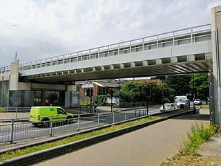
New Bermondsey railway station is a planned railway station with permission granted on the South London Line of the London Overground network. It will be on the branch from Surrey Quays to Clapham Junction with through trains every 15 minutes between Clapham Junction and Highbury & Islington. The station site is on Surrey Canal Road at the district boundary of Bermondsey, New Cross and Deptford. The station will be adjacent to Millwall Football Club's ground and would help ease the burden of match-day crowds on the nearby South Bermondsey railway station and Surrey Quays Station.
The Slough Arm is a short canal branch from the Grand Union Main Line to Slough in Berkshire, England. It was originally opened to serve the brick-making industry. The last commercial traffic was carried in 1960, but as the plans to fill it in were opposed locally, the stretch was re-opened in 1975 and has remained in-use since.
Rivers of London may refer to

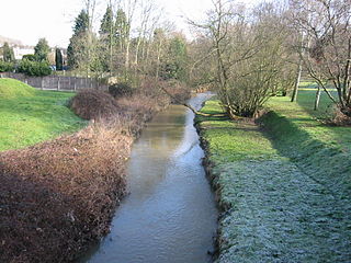
The Silk Stream is a brook just over 4 kilometres long in the London Borough of Barnet. It is one of the major components of the Blue Ribbon Network.
Canal & River Trust holds the guardianship of 2,000 miles of canals and rivers, together with reservoirs and a wide range of heritage buildings and structures, in England and Wales. Launched on 12 July 2012, the Trust took over the responsibilities of the state-owned British Waterways.
References
- ↑ Greater London Authority - Blue ribbon network policies Archived 10 March 2008 at the Wayback Machine
- ↑ Greater London Authority - The blue ribbon network Archived 31 May 2010 at the Wayback Machine
- ↑ Greater London Authority - London's water spaces policies Archived 26 May 2011 at the Wayback Machine
- ↑ Greater London Authority - Mayor announces key appointments to London Waterways Commission [ permanent dead link ]. 4-1-2006.
| This London-related article is a stub. You can help Wikipedia by expanding it. |
| This article related to water transport is a stub. You can help Wikipedia by expanding it. |