Stamford Brook was a tributary of the Tideway stretch of the River Thames in west London supplied by three headwaters. Historically used as an irrigation ditch or dyke, the network of small watercourses had four lower courses and mouths.
Stamford Brook was a tributary of the Tideway stretch of the River Thames in west London supplied by three headwaters. Historically used as an irrigation ditch or dyke, the network of small watercourses had four lower courses and mouths.
The name Stamford Brook may be a corruption of "stony ford", for a crossing by King Street. It has given its name to the surrounding area between Hammersmith and Chiswick, and to the local London Underground station, Stamford Brook.
The county of London created in 1889 was bounded by the westernmost course of Stamford Brook; it formed the boundary separating London Boroughs of Hammersmith and Acton in the new county from the Chiswick and Brentford Urban Districts in Middlesex. [1]
By 1900, all six strands of the brook and drainage dykes had been covered over and formed the most useful depressions available to site the neighbourhood's sewers, and many diversionary surface water drains had been created closer to the surface to drain the catchment basin. [2]
Stamford Brook has no known connection with Stamford Bridge, the site of a bridge which carries the Kings Road over the stream to the east called Counter's Creek which rose to the immediate west of Notting Hill. The West London bridge gives its name to Chelsea Football Club's adjoining ground. [3]
A western headwater, the Bollo Brook or Bollar Brook was the westernmost brook feeding the channels running through Chiswick and Hammersmith. This rose on the site of Ealing Common Underground station, [4] midway between Ealing and Acton and travelled south, then southeast, then divided, part was channelled south to Chiswick House and Chiswick; the remainder was channelled into four mouths described below. The main flow travelled east to the north of King Street, Hammersmith.
Surface water and foul water drains beside and under short stretches of Piccadilly and District lines [n 1] followed by the rear of numbers up to 438 Chiswick High Road, then turn ENE follow the lowest depression of that watercourse, cutting across Chiswick Common, crossing the District Line at Turnham Green tube station to reach the formerly seasonally waterlogged, low-lying area of Stamford Brook Common. [n 2]
Fresh water features such as the fishponds by the London Transport Museum Depot on the current location of Acton Town Underground station have been lost due to use of the depression for separate drainage systems. [4] [5]
An eastern headwater rose on Old Oak Common in Acton. [6] north east of the Old Acton Wells, also known as Acton Wells [n 3] and flowed south down Old Oak Common Road and Old Oak Road then SSE down Askew Road. [n 4] This course, now overtaken by segregation of surface water drainage and sanitary sewers afterwards ran the line of Paddenswick Road where it was joined by a flow emerging from Ravenscourt Park.
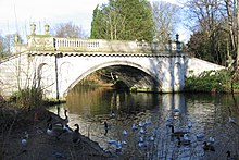
A middle headwater formed in North Acton near the interchange of the A40 and was known locally as the "Warple" — this ran southwards just west of Horn Lane, under the park Springfield Gardens turned east underneath the small park, The Woodlands by Ealing, Hammersmith and West London College in Acton, ran south of Acton High Street/the Vale behind the long-established swimming location fed from the mineral wells above, Acton Swimming Baths, then ran south down Warple Way where toward the end of this road is a large sewage storage and pumping station. [5] After this the brook split at The Brook public house on Stamford Brook Common. [8] One branch from this point headed east past Ravenscourt Park and fed the former moat there. [2]
From Paddenswick Road by Ravenscourt Park the original [2] [9] and middle mouth took a due south route along Dalling Road, [n 5] under King Street and through Hammersmith Registry Office, Cromwell Avenue to the River Thames. This mouth, once providing high tide mooring was known as Hammersmith Creek . [10]
The eastern mouth, Parr's Ditch was a more complicated, field-watering affair, an alternative brook as the main area inconveniently for agriculture overflowed at times and for irrigation of Hammersmith, that continued due east through Hammersmith into a natural trough, now the long park known as Brook Green. To reach this long green, a line parallel to Attwood and Kilmarsh Roads was taken, after Brook Green the route turned south and then southwest and took Collet Gardens, Wilson and Yeldham Roads to reach the Thames. [10] [11] [12]
A ditch of the western channel was funnelled to the southern depression of parkland in Chiswick to augment the waters in the grounds of Chiswick House. Its main supply the Hazeldene ran from a lake near Sydney House [n 6] to the west. The waters feed the lakes and fountains at Chiswick House, and then drain into the River Thames downstream of Barnes Bridge [13] An additional western channel was added from Stamford Green, running underneath Stamford Brook Avenue and British Grove. [2] Accordingly, elevations of Stamford Brook Avenue range from 4.8 to 5 metres (16 to 16 ft) whereas east in Ravensbourne Park, the destination of the stream depicted in early maps, the elevations are 4.4 to 4.2 metres (14 to 14 ft) AOB by Paddeswick Road. [5]
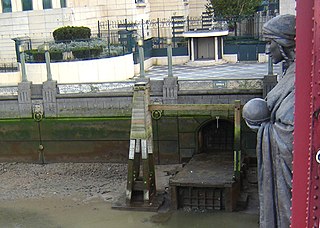
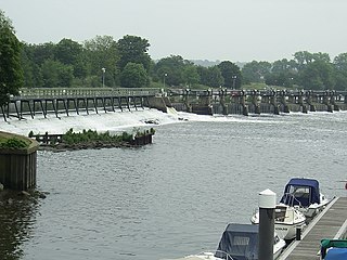
Close to the River Thames, the lower reaches of the above routes used for sanitary sewers are intercepted by Sir Joseph Bazalgette's Northern Low Level Sewer which reaches the Northern Outfall Sewer in Stratford, however directly south of the original mouth are overflow outfalls in Furnival Gardens and of the western mouth on Chiswick Eyot which regularly are in use during rainy days, leading to a major project underway, the Thames Tideway Scheme, [14] [15] a strong motivation for which is the desire to comply with the EU's Urban Waste Water Treatment Directive. [16]
Audacious plans in 2008 were proposed by a firm of architects whose chief vision was to recreate a marshy stream at the Walbrook, as in pre-Roman London, to recreate Hammersmith Creek in Hammersmith by putting the A4 underground. City planners consider however that while extra water provides a few expensive views for residents, it does not provide recreational or air quality improving space. [17]
| Ealing |
|  | |||||||||||||
|---|---|---|---|---|---|---|---|---|---|---|---|---|---|---|---|
| Hounslow |
| ||||||||||||||
| Transport | |||||||||||||||
| Other |
| ||||||||||||||

Acton is a town and area in west London, England, within the London Borough of Ealing. It is 6.1 miles (10 km) west of Charing Cross.

Chiswick is a district in the London Borough of Hounslow, West London, England. It contains Hogarth's House, the former residence of the 18th-century English artist William Hogarth; Chiswick House, a neo-Palladian villa regarded as one of the finest in England; and Fuller's Brewery, London's largest and oldest brewery. In a meander of the River Thames used for competitive and recreational rowing, with several rowing clubs on the river bank, the finishing post for the Boat Race is just downstream of Chiswick Bridge.

The London Borough of Hounslow is a London borough in West London, England, forming part of Outer London. It was created in 1965 when three smaller borough councils amalgamated under the London Government Act 1963. It is governed by Hounslow London Borough Council.

Acton Town is a London Underground station in the south-west corner of Acton, West London, in the London Borough of Ealing, close to the border with the London Borough of Hounslow. The station is served by the District and Piccadilly lines and is in Travelcard Zone 3. On the District line, it is between Chiswick Park and Ealing Common stations, and on the Piccadilly line it is between Hammersmith and Ealing Common on the Uxbridge branch & South Ealing on the Heathrow branch. Acton Town station was opened as Mill Hill Park on 1 July 1879 by the District Railway. It remained as a terminus until on 1 May 1883 and 23 June 1903 the DR opened two branches from Acton Town to Hounslow Town and Park Royal & Twyford Abbey respectively. On 4 July 1932 the Piccadilly line was extended to Acton Town. District line services to both the Hounslow and Uxbridge branches were withdrawn completely on 9 and 10 October 1964 after which operations were provided by the Piccadilly line alone.
The River Effra is a former set of streams in south London, England, culverted and used mainly for storm sewerage. It had been a tributary of the Thames. Its catchment waters, where not drained to aquifer soakaways and surface water drains, have been incorporated into 1850s-built combined sewer sectors, devised by Sir Joseph Bazalgette. One drains Peckham, the other Brixton, then intended to flow towards Peckham. These generally flow east to be treated at Crossness.

The Westbourne or Kilburn is a culverted small River Thames tributary in London, rising in Hampstead and Brondesbury Park and which as a drain unites and flows southward through Kilburn and Bayswater to skirt underneath the east of Hyde Park's Serpentine lake then through central Chelsea under Sloane Square. It passes centrally under the south side of Royal Hospital Chelsea's Ranelagh Gardens before discharging into Inner London's old-fashioned, but grandiose combined sewer system, with exceptional discharges into the Inner London Tideway. Since the latter 19th century, the population of its catchment has risen further but to reduce the toll it places on the Beckton Sewage Treatment Works and related bills its narrow basin has been assisted by private soakaways, and public surface water drains. Its depression has been replaced with and adopted as a reliable route for a gravity combined sewer. The formation of the Serpentine relied on the water, a lake with a long, ornate footbridge and various activities associated, which today uses little-polluted water from a great depth.

Turnham Green is a London Underground station in Chiswick of the London Borough of Hounslow, west London. The station is served by the District and Piccadilly lines although currently Piccadilly line trains normally stop at the station only at the beginning and end of the day, running through non-stop at other times. To the east, District line trains stop at Stamford Brook and Piccadilly line trains stop at Hammersmith. To the west, District line trains run to either Chiswick Park or Gunnersbury and Piccadilly line trains stop at Acton Town. The station is in both Travelcard Zone 2 and Zone 3.

The Metropolitan District Railway, also known as the District Railway, was a passenger railway that served London, England, from 1868 to 1933. Established in 1864 to complete an "inner circle" of lines connecting railway termini in London, the first part of the line opened using gas-lit wooden carriages hauled by steam locomotives. The Metropolitan Railway operated all services until the District Railway introduced its own trains in 1871. The railway was soon extended westwards through Earl's Court to Fulham, Richmond, Ealing and Hounslow. After completing the inner circle and reaching Whitechapel in 1884, it was extended to Upminster in Essex in 1902.

The Northern Outfall Sewer (NOS) is a major gravity sewer which runs from Wick Lane in Hackney to the Beckton Sewage Treatment Works in east London. Most of it was designed by Joseph Bazalgette, as a result of an outbreak of cholera in 1853 and the "Great Stink" of 1858.
Counter's Creek, ending in Chelsea Creek, the lowest part of which still exists, was a stream that flowed from Kensal Green, by North Kensington and flowed south into the River Thames on the Tideway at Sands End, Fulham. Its remaining open watercourse is the quay of Chelsea Creek.

Chiswick Park is a London Underground station in the Acton Green district of Chiswick in West London. The station is served by the District line and is between Turnham Green and Acton Town stations. It is located at the junction of Bollo Lane and Acton Lane about 150 m north of Chiswick High Road (A315) and is in Travelcard Zone 3. The station is near Acton Green common. The Piccadilly line uses the inside tracks, but often does not stop here.

Stamford Brook is a London Underground station on the eastern edge of Chiswick in west London. The station is served by the District line and is between Ravenscourt Park and Turnham Green stations. The main entrance is located on Goldhawk Road (A402) with a secondary entrance on Prebend Gardens. It is in Travelcard Zone 2.

The River Crane, a tributary of the River Thames, runs 8.5 miles (13.6 km) in West London, England. It forms the lower course of Yeading Brook. It adjoins or passes through three London boroughs: Hillingdon, Hounslow and Richmond upon Thames, in the historic county of Middlesex. The drainage basin is heavily urbanised but many of the Hayes to Whitton flood-meadows have been conserved, forming a narrow, green vale, opening out to what remains of Hounslow Heath in the centre – a near-continuous belt of semi-natural habitat.
Hammersmith is a parliamentary constituency in the House of Commons of the UK Parliament. It is currently represented by Andy Slaughter, a member of the Labour Party, who has represented the seat since its recreation in 2010.
The Tideway is a part of the River Thames in England which is subject to tides. This stretch of water is downstream from Teddington Lock. The Tideway comprises the upper Thames Estuary including the Pool of London.
London United Tramways Company Limited was an operator of trams and trolleybuses in the western and southern suburbs of London, UK, from 1894 to 1933, when it passed to the London Passenger Transport Board.

The Falconbrook was a stream that rose in Balham and Tooting, draining much of those parishes then the south and west of the larger district of Battersea including Clapham Junction to enter the London reaches of the Thames. Before doing so, it briefly formed the border of Wandsworth Town, reflected in the SW11/SW18 boundary today.

Sudbrook and its tributary, the Latchmere stream, are north-flowing streams in London, England, that drain northern Kingston upon Thames and the eastern extreme of Ham following a meander scar in a terrace; the upper part of the Sudbrook drains a narrow vale in Richmond Park's southern corner into the tidal Thames.
The Kensington and Richmond line was a railway in West London, England. It was built by the London and South Western Railway, which already had a main line to Richmond from London. The Kensington line was chiefly a defensive measure to limit the incursion of rival railways into LSWR territory. It ran from Kensington on the West London Railway, by way of Hammersmith, Turnham Green, Gunnersbury and Kew; it opened in 1869. It had a separate station at Richmond, in keeping with the LSWR intention of preventing competitors from easily obtaining running powers to go further into the LSWR area.