Acton Green, London

Last updated

Acton Green
Greater London UK location map 2.svg
Red pog.svg
Acton Green
Location within Greater London
OS grid reference TQ205805
  Charing Cross 5.9 mi (9.5 km)  WNW
London borough
Ceremonial county Greater London
Region
Country England
Sovereign state United Kingdom
Post town LONDON
Postcode district W4
Dialling code 020
Police Metropolitan
Fire London
Ambulance London
UK Parliament
London Assembly
List of places
UK
England
London
51°30′00″N00°15′54″W / 51.50000°N 0.26500°W / 51.50000; -0.26500

Acton Green is a residential neighbourhood in Chiswick and the London Borough of Ealing, in West London, England. It is named for the nearby Acton Green common. It was once home to many small laundries and was accordingly known as "Soapsuds Island".

Contents

History

Acton Green on the Ordnance Survey map of 1894 Acton Green OS map 1894.png
Acton Green on the Ordnance Survey map of 1894

The public parkland of Acton Green common adjoins Chiswick Back Common; before they were divided by the railway embankment for the District and Piccadilly lines, [1] both were part of the English Civil War battlefield of the Battle of Turnham Green. [2]

South Acton, especially the Acton Green district, was once famous for its laundries, and was known as "Soapsuds island". [3] There were some 60 laundries in 1873, rising to over 170 in 1890, most of the washing being done by hand. The 1901 census recorded as laundry workers 568 men and 2,448 women. The number of laundries fell to 50 in 1956, by then all automated: still the largest concentration of such businesses in Britain at that time. [4] The business supported light industries that produced laundry requisites, including baskets, laundry hampers, mangles, washing machines, tubs, and wringers. [5]

Facing the east of the common is St Michael and All Angels, Bedford Park; it and The Tabard Inn facing it across Bath Road, were built in 1880. [6] [7] The 1894 Ordnance Survey map shows Acton Green bounded to the west by railway lines, and to the east by the boundary of Bedford Park; at that time, both the west of Bedford Park and the east of Acton Green consisted of orchards. [8]

Housing

Most of the housing of Acton Green is to the northwest of the common; to its east is the Bedford Park area, developed speculatively as a place for artists at the same time as St Michael's and The Tabard. [9] There were formerly numerous small shops in the centre of Acton Green on Cunnington Street and Kingswood Road. These included confectioners, fish and chip shops, grocers, and off-licences. The area also held a variety of schools, now all closed. [5]

St Alban's Church

On the north side of the common, facing South Parade, is the red-brick with stone facings neo-Gothic Victorian era St Alban's Church, Acton Green by Edward Monson Jr; it was opened in 1888. It is described as the focus of the Acton Green Conservation area; the church building is Grade II listed. The nearby vicarage uses the same red brick and stone window surrounds and mullions. [10] [1] [11] [12]

West side of the common

Facing the west of the common are the mansion flats of the locally listed four-storey red brick Fairlawn Court, built around 1900. Just to its north are the loft apartments of Chiswick Green Studios, a "modish conversion" [1] of a group of industrial buildings. [1] The buildings from 1930 and 1950 had been the military electronics components factory of Evershed & Vignoles. They were converted to form apartments, including new penthouses through the addition of a curved roof; a third building retained only the original frame and was made into cheaper "loft style" apartments. [13]

Public houses

Duke of Sussex

Nearby, facing the north of the common is the 1898 Duke of Sussex public house; it replaced an earlier beerhouse founded by 1842. [14] The current "elaborately decorated" [1] building was designed by the pub architects Shoebridge & Rising, and is Grade II listed. It has two storeys, with dormer windows for the attic and cellars below. The main front faces east on to Beaconsfield Road, with three bays, two of them with dormers, separated by a small half-round Diocletian window, and the third an extension to house the kitchens and staircase. The walls are covered in white stucco, with the first storey hung with flat red tiles. [1] [15] The first storey and attic windows below the dormers are "Ipswich oriels" under ornamental cornices. The ground floor bar area has big arched windows, and an elaborate corner doorway; the doorway to the north is adorned with ornamental ironwork. Parts of the original interior partitioning survive, providing "an unusually rich, turn-of-the-century pub interior". [1]

Other

On the corner of Bollo Lane, which marks the western edge of the area, and Montgomery Road is the Bollo, a gastropub. It opened soon after 1900 as 'The Railway Hotel', complete with a painting of a railway locomotive on the outside wall. It then became in turn 'The Railway Tavern', 'The Orange Kipper' (1988), 'The Bollo House', and finally the Bollo. [14]

On the corner of Evershed Walk and Acton Lane is The Swan, opened in 1871 by the Phoenix Brewery of Latimer Road in what had been a beerhouse owned by James Brown. Its exterior featured in a 1980s television situation comedy. [16] It is described by Harden's guide as a "lovely panelled pub" with attractive garden, serving good food. [17]

Transport

Chiswick Park tube station on the District line, and Turnham Green tube station on the District and Picadilly lines, are at the western and eastern ends of Acton Green common.

South Acton is the nearest National Rail station and is on the North London Line. Chiswick railway station is the closest for services into London Waterloo.

The London Buses route 94 to Piccadilly Circus terminates at the northwestern corner of Acton Green common. [18]

Related Research Articles

<span class="mw-page-title-main">Acton, London</span> Town in Greater London, England

Acton is a town and area in west London, England, within the London Borough of Ealing. It is 6.1 miles (10 km) west of Charing Cross.

<span class="mw-page-title-main">Chiswick</span> Riverside district of London, England

Chiswick is a district in the London Borough of Hounslow, West London, England. It contains Hogarth's House, the former residence of the 18th-century English artist William Hogarth; Chiswick House, a neo-Palladian villa regarded as one of the finest in England; and Fuller's Brewery, London's largest and oldest brewery. In a meander of the River Thames used for competitive and recreational rowing, with several rowing clubs on the river bank, the finishing post for the Boat Race is just downstream of Chiswick Bridge.

<span class="mw-page-title-main">Acton Town tube station</span> London Underground station

Acton Town is a London Underground station in the south-west corner of Acton, West London, in the London Borough of Ealing, close to the border with the London Borough of Hounslow. The station is served by the District and Piccadilly lines and is in Travelcard Zone 3. On the District line, it is between Chiswick Park and Ealing Common stations, and on the Piccadilly line it is between Hammersmith and Ealing Common on the Uxbridge branch & South Ealing on the Heathrow branch. Acton Town station was opened as Mill Hill Park on 1 July 1879 by the District Railway. It remained as a terminus until on 1 May 1883 and 23 June 1903 the DR opened two branches from Acton Town to Hounslow Town and Park Royal & Twyford Abbey respectively. On 4 July 1932 the Piccadilly line was extended to Acton Town. District line services to both the Hounslow and Uxbridge branches were withdrawn completely on 9 and 10 October 1964 after which operations were provided by the Piccadilly line alone.

<span class="mw-page-title-main">Turnham Green tube station</span> London Underground station

Turnham Green is a London Underground station in Chiswick of the London Borough of Hounslow, west London. The station is served by the District and Piccadilly lines although currently Piccadilly line trains normally stop at the station only at the beginning and end of the day, running through non-stop at other times. To the east, District line trains stop at Stamford Brook and Piccadilly line trains stop at Hammersmith. To the west, District line trains run to either Chiswick Park or Gunnersbury and Piccadilly line trains stop at Acton Town. The station is in both Travelcard Zone 2 and Zone 3.

<span class="mw-page-title-main">Stamford Brook</span> Subterranean river in London, England

Stamford Brook was a tributary of the Tideway stretch of the River Thames in west London supplied by three headwaters. Historically used as an irrigation ditch or dyke, the network of small watercourses had four lower courses and mouths.

<span class="mw-page-title-main">Chiswick Park tube station</span> London Underground station

Chiswick Park is a London Underground station in the Acton Green district of Chiswick in West London. The station is served by the District line and is between Turnham Green and Acton Town stations. It is located at the junction of Bollo Lane and Acton Lane about 150 m north of Chiswick High Road (A315) and is in Travelcard Zone 3. The station is near Acton Green common. The Piccadilly line uses the inside tracks, but often does not stop here.

<span class="mw-page-title-main">Turnham Green</span> Human settlement in England

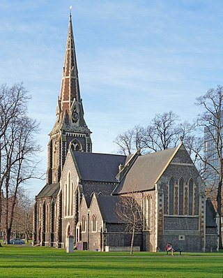
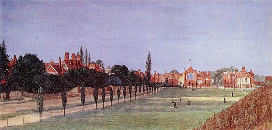
Turnham Green is a public park on Chiswick High Road, Chiswick, London, and the neighbourhood and conservation area around it; historically, it was one of the four medieval villages in the Chiswick area, the others being Old Chiswick, Little Sutton, and Strand-on-the-Green. Christ Church, a neo-Gothic building designed by George Gilbert Scott and built in 1843, stands on the eastern half of the green. A war memorial stands on the eastern corner. On the south side is the old Chiswick Town Hall.

<span class="mw-page-title-main">Bedford Park, London</span> Suburban development in London, England

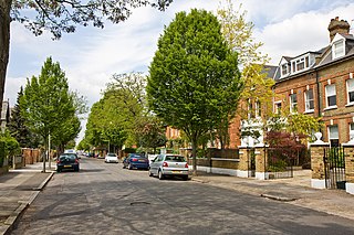
Bedford Park is a suburban development in Chiswick, London, begun in 1875 under the direction of Jonathan Carr, with many large houses in British Queen Anne Revival style by Norman Shaw and other leading Victorian era architects including Edward William Godwin, Edward John May, Henry Wilson, and Maurice Bingham Adams. Its architecture is characterised by red brick with an eclectic mixture of features, such as tile-hung walls, gables in varying shapes, balconies, bay windows, terracotta and rubbed brick decorations, pediments, elaborate chimneys, and balustrades painted white.

South Acton is an area in Acton, West London, 6.4 miles (10.3 km) west of Charing Cross. At the 2001 census, Acton, comprising the wards of East Acton, Acton Central, South Acton and Southfield, had a population of 53,689 people.

<span class="mw-page-title-main">Tabard Theatre</span>

The Tabard Theatre is a small 96-seat theatre in Chiswick in the London Borough of Hounslow. Close to Turnham Green Underground station, it is situated above the Tabard public house on Bath Road. The Tabard Theatre was licensed and opened for theatre use in 1985. It was renamed as the Chiswick Playhouse in 2019 which closed in March 2022. It is reopening as the Tabard in September 2022.

Grove Park is an area in the south of Chiswick, now in the borough of Hounslow, West London. It lies in the meander of the Thames occupied by Duke's Meadows park. Historically, the area belonged to one of the four historic villages in modern Chiswick, Little Sutton. It was long protected from building by the regular flooding of the low-lying land by the River Thames, remaining as orchards, open fields, and riverside marshland until the 1880s. Development was stimulated by the arrival of the railway in 1849; Grove Park Hotel followed in 1867, soon followed by housing.

<span class="mw-page-title-main">Old Pack Horse</span> Public house in Chiswick, London

The Old Pack Horse is a Grade II listed public house in a prominent position on the corner of Chiswick High Road and Acton Lane in Chiswick, London.

<span class="mw-page-title-main">The Tabard, Chiswick</span> Pub in Chiswick, London

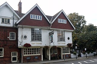
The block of three buildings containing The Tabard public house is a Grade II* listed structure in Chiswick, London. The block, with a row of seven gables in its roof, was designed by Norman Shaw in 1880 as part of the community focus of the Bedford Park garden suburb. The block contains the Bedford Park Stores, once a co-operative, and a house for the manager.

<span class="mw-page-title-main">St Alban's Church, Acton Green</span> Church in London, England

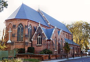
St Alban's Church, Acton Green, also called St Alban the Martyr, is a church on South Parade, Acton Green in Chiswick, west London, designed by Edward Monson Jr. and opened in 1888.

<span class="mw-page-title-main">Old Chiswick</span> Village in London

Old Chiswick is the area of the original village beside the river Thames for which the modern district of Chiswick is named. The village grew up around St Nicholas Church, founded c. 1181 and named for the patron saint of fishermen. The placename was first recorded c. 1000 as Ceswican. In the Middle Ages the villagers lived by fishing, boatbuilding, and handling river traffic. The surrounding area was rural until the late 19th century.

<span class="mw-page-title-main">Duke of Sussex, Acton Green</span> Pub in Acton Green, London

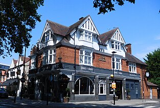
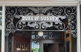
The Duke of Sussex, Acton Green is a public house, opened in 1898, in the northern Chiswick district of Acton Green. It is prominently situated on a corner facing the common. The Grade II listed building is "elaborately decorated" to a design by the pub architects Shoebridge & Rising.

<span class="mw-page-title-main">Old Fire Station, Chiswick</span> Fire station building in Chiswick

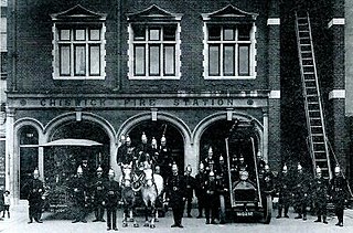
The Old Fire Station, Chiswick is an 1891 brick building with stone facings on Chiswick High Road. It served as a fire station until 1963, and has since been used as a restaurant.

<span class="mw-page-title-main">Chiswick High Road</span> Street in the London Borough of Hounslow

Chiswick High Road is the principal shopping and dining street of Chiswick, a district in the west of London. It was part of the main Roman road running west out of London, and remained the main road until the 1950s when the A4 was built across Chiswick. By the 19th century the road through the village of Turnham Green had grand houses beside it. The road developed into a shopping centre when Chiswick became built up with new streets and housing to the north of Old Chiswick, late in the 19th century. There are several listed buildings including public houses, churches, and a former power station, built to supply electricity to the tram network.

<span class="mw-page-title-main">Church of Our Lady of Grace & St Edward, Chiswick</span>

The 1886 Church of Our Lady of Grace & St Edward, serving the Roman Catholic parish of Chiswick, stands on the south side of Chiswick High Road, on the corner with Duke's Avenue.

<span class="mw-page-title-main">Architecture of Bedford Park</span> Architectural design of a West London suburb

The architecture of Bedford Park in Chiswick, West London, is characterised largely by Queen Anne Revival style, meaning an eclectic mixture of English and Flemish house styles from the 17th and 18th centuries, with elements of many other styles featuring in some of the buildings.

References

  1. 1 2 3 4 5 6 7 "Acton Green Conservation Area Character Appraisal" (PDF). Ealing Borough Council. March 2008. pp. 5, 7, 15–16.
  2. "The Battle of Turnham Green". Chiswick W4. 19 November 2004. Retrieved 13 November 2015.
  3. "Acton's Industry: South Acton - Soapsud Island". Acton History. Retrieved 23 July 2021.
  4. A History of the County of Middlesex: Volume 7, Acton, Chiswick, Ealing and Brentford, West Twyford, Willesden. Vol. 7. Victoria County History. 1982. pp. 23–30.
  5. 1 2 "History". Acton Green Residents' Association. 2021. Retrieved 13 August 2021.
  6. Cherry, Bridget; Pevsner, Nikolaus (1991). The Buildings of England. London 3: North West. London: Penguin Books. p. 409. ISBN   978-0-14-071048-9. OCLC   24722942.
  7. "A brief history of the Church". St Michael & All Angels. Retrieved 19 November 2015. This is based on Broom, Michael. The Birth of A Parish – The Creation of St Michael & All Angels, Bedford Park. St Michael & All Angels.
  8. "Map of Chiswick, 1893 - 1894". Ordnance Survey. 1894. Retrieved 13 August 2021. Scale 1:10,560 Ordnance Survey County Edition Series
  9. Rowley, Trevor (2006). The English landscape in the twentieth century. London: Hambledon Continuum. pp.  84. ISBN   1-852853883. OCLC   61702983.
  10. Pevsner, Nikolaus (1951). The Buildings of England: Middlesex. Penguin Books.
  11. "St Alban's on South Parade, Acton Green, London W4". The Victorian Web. 7 July 2017. Retrieved 2 November 2018.
  12. A History of the County of Middlesex: Volume 7, Acton, Chiswick, Ealing and Brentford, West Twyford, Willesden. Vol. 7. Victoria County History. 1982. pp. 35–39.
  13. "Chiswick Green Studios". Architecture Arc. Retrieved 22 July 2021.
  14. 1 2 Clegg, Gillian. "Pubs". Brentford and Chiswick Local History Society. Retrieved 23 July 2021.
  15. Cherry, Bridget; Pevsner, Nikolaus (1991). The Buildings of England. London 3: North West. London: Penguin Books. p. 162. ISBN   978-0-14-071048-9. OCLC   24722942.
  16. "Swan". Campaign for Real Ale . Retrieved 23 July 2021.
  17. "The Swan". Harden's . Retrieved 23 July 2021.
  18. Blacker, Ken (2007). Routemaster: 1970–2005. Vol. 2 (2nd ed.). Harrow Weald: Capital Transport. pp. 116, 167, 168. ISBN   978-1-85414-303-7.