Pitshanger

Last updated

Pitshanger
Pitshanger Lane, Ealing - geograph.org.uk - 2864690.jpg
Pitshanger Lane
Greater London UK location map 2.svg
Red pog.svg
Pitshanger
Location within Greater London
London borough
Ceremonial county Greater London
Region
Country England
Sovereign state United Kingdom
Post town LONDON
Postcode district W5
Dialling code 020
Police Metropolitan
Fire London
Ambulance London
London Assembly
List of places
UK
England
London
51°31′35″N0°18′46″W / 51.526313°N 0.312734°W / 51.526313; -0.312734 Coordinates: 51°31′35″N0°18′46″W / 51.526313°N 0.312734°W / 51.526313; -0.312734

Pitshanger (sometimes referred to as Pitshanger Village) is a small but busy local suburb, centred on the shops in Pitshanger Lane, located about 1 mile north of Ealing Broadway in west London. First mentioned in 1493, [1] possibly meaning an area of sloped woodland frequented by birds. It contains numerous small independent shops, several cafes, two pubs, two churches, a school, and a park (Pitshanger Park), and is often taken to also include parts of the nearby Brentham Garden Suburb.

Contents

Amenities

Ted Saunders, who was a traditional fishmonger in Pitshanger for over 50 years. Ted Saunders of TH Carr 18 May 2013.jpg
Ted Saunders, who was a traditional fishmonger in Pitshanger for over 50 years.

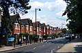
Pitshanger Lane (originally Pitshanger Road [2] ) is one of the busiest roads in Ealing, and provides a wide range of shops. The Pitshanger Village Library has recently been improved[ citation needed ] and the Lane is furnished with touch-screen computers. A Methodist and an Anglican church are both located at the end of the Lane. Due to its large size and possession of a Bösendorfer grand piano, St. Barnabas (Church of England) is the venue for, besides the usual services, a series of classical music concerts given by local musicians and others. These include regular recitals every Friday lunchtime. Attendance is free with a retiring collection. The current vicar of St Barnabas is Father Justin Dodd; [3] the Director of Music is Kavi Pau and the Assistant Director of Music is Henry Tozer who runs a gospel choir. Away from Pitshanger Lane, the Pitshanger area features Pitshanger Park, which includes allotments for locals' use. Featuring two children's playground areas, football goalposts, a bowling green and several tennis courts, Pitshanger Park caters for both children and adults.

Schooling also exists on Pitshanger Lane, with North Ealing Primary School located at one end of the Lane. The school is a comprehensive, co-education school for pupils up to the age of eleven. St. Gregory's R.C. School is also coeducational and located just off Pitshanger Lane.

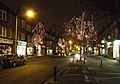
In May 2016, Pitshanger Lane was named London's best high street by The Great British High Street, and a plaque was unveiled. [4]

Transport

The area is served by buses E2 and E9 and night bus N7.

Related Research Articles

Hounslow Town in the west of London, England

Hounslow is a large suburban district of West London, 10.7 miles (17.2 km) west-southwest of Charing Cross. It is the administrative centre of the London Borough of Hounslow, and is identified in the London Plan as one of the 12 metropolitan centres in Greater London.

Chiswick Riverside district of London, England

Chiswick is a district of west London, England. It contains Hogarth's House, the former residence of the 18th-century English artist William Hogarth; Chiswick House, a neo-Palladian villa regarded as one of the finest in England; and Fuller's Brewery, London's largest and oldest brewery. In a meander of the River Thames used for competitive and recreational rowing, with several rowing clubs on the river bank, the finishing post for the Boat Race is just downstream of Chiswick Bridge.

Golders Green Human settlement in England

Golders Green is an area in the London Borough of Barnet in England. A smaller suburban linear settlement, near a farm and public grazing area green of medieval origins, dates to the early 19th century. Its bulk forms a late 19th century and early 20th century suburb with a commercial crossroads. The rest is of later build. It is centred approximately 6 miles (9 km) north west of Charing Cross on the intersection of Golders Green Road and Finchley Road.

Hanwell Human settlement in England

Hanwell is a town in the London Borough of Ealing, in the historic County of Middlesex, England. It is about 1.5 miles west of Ealing Broadway and had a population of 28,768 as of 2011. It is the westernmost location of the London post town.

Muswell Hill Human settlement in England

Muswell Hill is a suburban district of the London Borough of Haringey, north London. The hill, which reaches 335ft above sea level, is situated 5.5 miles north of Charing Cross.

Southall Suburban district in London Borough of Ealing, England

Southall is a large suburban district of West London, England, part of the London Borough of Ealing and is one of its seven major towns. It is situated 10.7 miles (17.2 km) west of Charing Cross and had a population of 69,857 as of 2011. It is generally divided in three parts: the mostly residential area around Lady Margaret Road ; the main commercial centre at High Street and Southall Broadway ; and Old Southall/Southall Green to the south consisting of Southall railway station, industries and Norwood Green bounded by the M4.

Ealing Human settlement in England

Ealing is a district in West London, England. It is 7.5 miles (12.1 km) west of Charing Cross. In the London Borough of Ealing, it is one of the borough's seven major towns. Ealing, resembling the W5, W13 and NW10 post codes is the administrative centre of the borough. It is identified as a major metropolitan centre in the London Plan.

Shepherds Bush Human settlement in England

Shepherd's Bush is a district of West London, England, within the London Borough of Hammersmith and Fulham 4.9 miles (7.9 km) west of Charing Cross, and identified as a major metropolitan centre in the London Plan.

Gymea, New South Wales Suburb of Sydney, New South Wales, Australia

Gymea is a suburb in southern Sydney, in the state of New South Wales, Australia. Gymea is located 26 kilometres south of the Sydney central business district in the local government area of the Sutherland Shire. The postcode is 2227, which it shares with adjacent suburb Gymea Bay.

River Brent River in London, England

The River Brent is a river in west and northwest London, England, and a tributary of the River Thames. 17.9 miles (28.8 km) in length, it rises in the Borough of Barnet and flows in a generally south-west direction before joining the Tideway stretch of the Thames at Brentford.

West Ealing Human settlement in England

West Ealing is a district in the London Borough of Ealing, in West London. The district is about three-quarters of a mile (1.2 km) west of Ealing Broadway. Although there is a long history of settlement in the area, West Ealing in its present form is less than one hundred years old. West Ealing falls under the postcode district W13 and neighbours Hanwell, Ealing, Perivale and Northfields

Mossley Hill Human settlement in England

Mossley Hill is a suburb of Liverpool and a Liverpool City Council ward. Located to the south of the city, it is bordered by Aigburth, Allerton, Childwall, and Wavertree. At the 2001 Census, the population was 12,650, increasing to 13,816 at the 2011 Census.

Raynes Park Human settlement in England

Raynes Park is a residential suburb, railway station and local centre in Wimbledon, London, and is within the London Borough of Merton. It is situated south-west of Wimbledon Common, to the north-west of Wimbledon Chase and to the east of New Malden, in South West London. It is 7.8 miles (12.5 km) south-west of Charing Cross. Towards the north and west, either side of the borough boundary with the Royal Borough of Kingston upon Thames are the areas of Copse Hill and Coombe with their large detached houses, golf courses and gated lands. Raynes Park had a population of 19,619 in 2011, which refers to the populations of the wards of Raynes Park and West Barnes.

Temple Fortune Human settlement in England

Temple Fortune is a place in the London Borough of Barnet to the north of Golders Green. It is principally a shopping district used by residents of the Hampstead Garden Suburb. Between here and Golders Green, at Hoop Lane are two cemeteries – Golders Green Jewish Cemetery and Golders Green Crematorium. Religious buildings include the Catholic Church of St Edward the Confessor, St. Mary & Archangel Michael Coptic Orthodox Church, and North Western Reform Synagogue.

Pitzhanger Manor

Pitzhanger Manor is an English country house famous as the home of neoclassical architect, Sir John Soane. Built between 1800 and 1804 in Walpole Park Ealing, then to the west of London), the Regency Manor is a rare and spectacular example of a building designed, built and lived in by Sir John Soane himself. Soane intended it as a domestic space to entertain guests in, as well as a family home for a dynasty of architects, starting with his sons.

Shenfield Human settlement in England

Shenfield is an affluent commuter suburb of Brentwood and former civil parish, now in the unparished area of Brentwood, in the borough of Brentwood, Essex, England. In 1931 the parish had a population of 3501.

Parks and open spaces in the London Borough of Ealing

The London Borough of Ealing, one of the outer London boroughs although not on the periphery, has over 100 parks and open spaces within its boundaries. These include allotments, cemeteries, playgrounds, and golf courses in addition to the larger open spaces such as nature conservation areas. The main areas are:

West Dulwich Human settlement in England

West Dulwich is an area in south London, England, which straddles the London Borough of Lambeth and the London Borough of Southwark. Croxted Road and South Croxted Road mark the boundary between Southwark to the east and Lambeth to the west. The suburb of West Dulwich dates back to the 17th century when the often flooded land known as Dulwich Common was acquired and drained by Edward Alleyn's estate.

Northfields, London Human settlement in England

Northfields is an area in Ealing, west London. It is centred on Northfield Avenue, a shopping street of mostly independent shops and restaurants. It lies partially in the Ealing W5 and partially in west Ealing's W13 postcode. It lies in the southwest corner of Ealing.

St Stephens Church, Ealing Church in West Ealing, United Kingdom

St Stephen's Church is a Church of England church in the northern part of West Ealing, London. It was founded in 1867 as a mission and is now established as a separate parish. The first church building was a temporary iron church which was then replaced in 1876 by a substantial Victorian Gothic stone building which is now Grade II listed. Subsidence made that unsafe and it was deconsecrated in 1979. It has been converted to flats but still forms the landmark centrepiece of the St Stephen's Conservation Area. The congregation now holds services on the site of the church hall which has been redeveloped as the third church building and church centre.

References

  1. "Pitshanger Village - Hidden London".
  2. "Pitshanger Village - Hidden London".
  3. "Staff Team)". Barnabites.
  4. "Pitshanger Lane celebrates London's best high street success | Ealing Council". Archived from the original on 15 August 2020.

Further reading