Little Sutton, Chiswick

Last updated

Little Sutton area on Ordnance Survey map, c. 1880. Little Sutton is top centre; Kew Bridge and Strand-on-the-Green top left; Chiswick House and Gardens top centre right, and Old Chiswick top right. Grove House and its Park are centre left between the river and the railway leading to Barnes Railway Bridge. A broad strip beside the river is marked as marsh; much of the peninsula is shown as orchard (arrays of dots) or open fields. Grove Park area on Sheet 021, Ordnance Survey, 1868-1883.jpg
Little Sutton area on Ordnance Survey map, c. 1880. Little Sutton is top centre; Kew Bridge and Strand-on-the-Green top left; Chiswick House and Gardens top centre right, and Old Chiswick top right. Grove House and its Park are centre left between the river and the railway leading to Barnes Railway Bridge. A broad strip beside the river is marked as marsh; much of the peninsula is shown as orchard (arrays of dots) or open fields.

Little Sutton was one of the four constituent medieval villages of Chiswick, in what is now West London, and the site of a royal manor house, Sutton Manor, later Sutton Court. The great house was accompanied by a small hamlet without a church of its own.

Contents

The manor was used by four kings of England, Richard II, Henry IV, Henry V, and Henry VI, and Mary, Oliver Cromwell's daughter, lived there. The name survives in local street and house names.

Geography

Much of the area was still rural until late in the 19th century. Little Sutton, one of the four constituent villages of Chiswick, was about the centre of the parish of Chiswick at that time; Strand-on-the-Green lies to the west, Old Chiswick to the east, and Turnham Green to the north. It is now part of the Grove Park district. [1]

History

Sutton Manor

Map of Sutton Court and Chiswick House by Peter Potter, 1818. Chiswick House is on the right in its landscaped grounds (dark green); the "river" (blue) is the remodelled Bollo Brook, and Fauconberg's "The Park" (white), acquired by Burlington for Chiswick House below it. Sutton Court is left centre, the old moated house enclosure to its north, and its fields just across the curving lane (now Fauconberg Road). Sutton Court and Chiswick House Peter Potter 1818.jpg
Map of Sutton Court and Chiswick House by Peter Potter, 1818. Chiswick House is on the right in its landscaped grounds (dark green); the "river" (blue) is the remodelled Bollo Brook, and Fauconberg's "The Park" (white), acquired by Burlington for Chiswick House below it. Sutton Court is left centre, the old moated house enclosure to its north, and its fields just across the curving lane (now Fauconberg Road).

Sutton Manor is recorded from 1181. The lands of Sutton and Chiswick had by then already been given as an endowment for the Bishop of London and St Paul's Cathedral. It consisted of about half a square mile of arable fields and small areas of meadow and woods. In 1458 it had its own watermill. [2] [3] It was a Crown holding in the 14th and 15 centuries; in 1396, king Richard II built a royal residence here, complete with a chapel, a hall, and a moat. [2] The house was used by kings Henry IV and Henry V; Henry VI used a later house from at least 1441–1443. [2] Others who used the house included Sir Thomas More, Lord High Chancellor to Henry VIII, in 1524; the speaker of the House of Commons Chaloner Chute, in 1639; and Thomas Belasyse, Viscount Fauconberg in 1675; his wife, Mary, Oliver Cromwell's daughter, lived in the house until 1713, and is buried in St Nicholas Church, Chiswick. [2] [3] [4] By 1589 the great house was accompanied by farm buildings, a malthouse, and a gatehouse, with 3 acres of gardens and orchards. [2] By 1674 the walled garden extended to 12 acres, and by 1691 the gardens included a bowling green and a maze. [2] The field around the old moated enclosure was called Berry-gates until at least 1818. for "gated burh ", a fortified place; the name survives in the nearby Barrowgate Road. [3]

Sutton Court

In 1795 the house was remodelled as Sutton Court; it stood to the south of the former moated house, at what is now the corner of Sutton Court Road and Fauconberg Road. In 1845 it served as a boy's boarding school, run by Frederick Tappenden. It was demolished and replaced by the "Sutton Court Mansions" block of flats in 1905. [2] [3]

Little Sutton

Little Sutton was never more than a small hamlet without a church; by 1703 there were some almshouses, and there appears to have been an inn named the Queen's Head, documented in 1722 and 1862 (if they were the same building). [5] It was simply named Sutton in 1181; this developed into "Sutton Chiswick" or "Sutton by Chiswick" in the 14th and 15th centuries; "Sutton Beauregard" in the 1450s, for the view south over the river to the Surrey hills when the manor (later called Sutton Court) belonged to the Crown; and finally Little Sutton by 1590. [5] By 1801 there were 14 houses in Little Sutton. [5] One building, the 1676 Little Sutton Cottage, survives on Sutton Lane South, facing the main A4 dual carriageway; it is now Grade II listed. [6] [7] The village inn, the Queen's Head, now called the Hole in the Wall, is on Sutton Lane North, just across the A4. The building, much altered in 1925, dates from 1676. [7]

Related Research Articles

<span class="mw-page-title-main">Chiswick</span> Riverside district of London, England

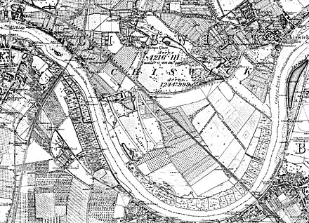
Chiswick is a district in the London Borough of Hounslow, West London, England. It contains Hogarth's House, the former residence of the 18th-century English artist William Hogarth; Chiswick House, a neo-Palladian villa regarded as one of the finest in England; and Fuller's Brewery, London's largest and oldest brewery. In a meander of the River Thames used for competitive and recreational rowing, with several rowing clubs on the river bank, the finishing post for the Boat Race is just downstream of Chiswick Bridge.

<span class="mw-page-title-main">London Borough of Hounslow</span> London borough in United Kingdom

The London Borough of Hounslow is a London borough in West London, England, forming part of Outer London. It was created in 1965 when three smaller borough councils amalgamated under the London Government Act 1963. It is governed by Hounslow London Borough Council.

Gunnersbury is an area of West London, England.

<span class="mw-page-title-main">Isleworth</span> Suburban town in Greater London

Isleworth is a town located within the London Borough of Hounslow in West London, England. It lies immediately east of the town of Hounslow and west of the River Thames and its tributary the River Crane. Isleworth's original area of settlement, alongside the Thames, is known as 'Old Isleworth'. The north-west corner of the town, bordering on Osterley to the north and Lampton to the west, is known as 'Spring Grove'.

<span class="mw-page-title-main">Cromwell Road</span> Road in the Royal Borough of Kensington and Chelsea, London, England

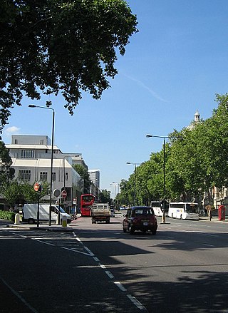
Cromwell Road is a major London road in the Royal Borough of Kensington and Chelsea, designated as part of the A4. It was created in the 19th century and is said to be named after Richard Cromwell, son of Oliver Cromwell, who once owned a house there.

Brentford was a local government district in the county of Middlesex, England from 1874 to 1927.

<span class="mw-page-title-main">Strand-on-the-Green</span> Riverside area in West London, England

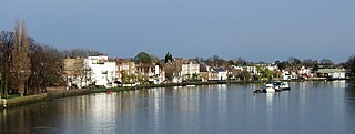
Strand-on-the-Green is one of Chiswick's four medieval villages, and a "particularly picturesque" riverside area in West London. It is a conservation area, with many "imposing" listed buildings beside the River Thames; a local landmark, the Kew Railway Bridge that crosses the River Thames and the Strand, is itself Grade II listed. Oliver's Island is just offshore.

<span class="mw-page-title-main">Turnham Green</span> Human settlement in England

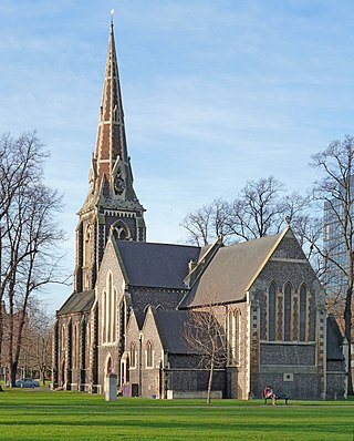
Turnham Green is a public park on Chiswick High Road, Chiswick, London, and the neighbourhood and conservation area around it; historically, it was one of the four medieval villages in the Chiswick area, the others being Old Chiswick, Little Sutton, and Strand-on-the-Green. Christ Church, a neo-Gothic building designed by George Gilbert Scott and built in 1843, stands on the eastern half of the green. A war memorial stands on the eastern corner. On the south side is the old Chiswick Town Hall.

<span class="mw-page-title-main">Great Ealing School</span> Phrontistery

Great Ealing School was situated on St Mary's Road, Ealing W5 London and was founded in 1698. In its heyday of the 19th century, it was as famous as Eton or Harrow, being considered "the best private school in England".

Grove Park is an area in the south of Chiswick, now in the borough of Hounslow, West London. It lies in the meander of the Thames occupied by Duke's Meadows park. Historically, the area belonged to one of the four historic villages in modern Chiswick, Little Sutton. It was long protected from building by the regular flooding of the low-lying land by the River Thames, remaining as orchards, open fields, and riverside marshland until the 1880s. Development was stimulated by the arrival of the railway in 1849; Grove Park Hotel followed in 1867, soon followed by housing.

<span class="mw-page-title-main">Mary Cromwell, Countess Fauconberg</span> Eighth child of Oliver Cromwell, Lord Protector and Elizabeth Cromwell (née Bourchier)

Mary Cromwell, Countess Fauconberg was an English noblewoman, the third daughter of Oliver Cromwell and his wife Elizabeth Bourchier.

<span class="mw-page-title-main">St Nicholas Church, Chiswick</span> Church in London, England

St Nicholas Church, Chiswick is a Grade II* listed Anglican church in Church Street, Chiswick, London, near the River Thames. Old Chiswick developed as a village around the church from c. 1181. The tower was built at some time between 1416 and 1435.

<span class="mw-page-title-main">Nowell Parr</span>

Thomas Henry Nowell Parr FRIBA was a British architect, best known for designing pubs in west London. Many of these were built while Parr was "house architect" for Fuller's Brewery. Parr designed various buildings in Brentford while he was surveyor and then architect to the Council from 1894 to 1907.

<span class="mw-page-title-main">Bull's Head, Strand-on-the-Green</span> Pub in Chiswick, London

The Bull's Head is a Grade II listed public house at 15 Strand-on-the-Green, Chiswick, London, England. The building is 18th century with later additions; the architect is not known. It is a two-storey white-painted brick building, and still has its pantile roof with two dormer windows. The entrance has a moulded doorhood resting on brackets. Inside, the pub's bar and drinking area consists of numerous rooms on different levels; the lowest room is the "Duck & Grouse" restaurant.

<span class="mw-page-title-main">Chiswick Mall</span> Waterfront street in Chiswick, west London

Chiswick Mall is a waterfront street on the north bank of the river Thames in the oldest part of Chiswick in West London, with a row of large houses from the Georgian and Victorian eras overlooking the street on the north side, and their gardens on the other side of the street beside the river and Chiswick Eyot.

<span class="mw-page-title-main">Old Chiswick</span> Village in London

Old Chiswick is the area of the original village beside the river Thames for which the modern district of Chiswick is named. The village grew up around St Nicholas Church, founded c. 1181 and named for the patron saint of fishermen. The placename was first recorded c. 1000 as Ceswican. In the Middle Ages the villagers lived by fishing, boatbuilding, and handling river traffic. The surrounding area was rural until the late 19th century.

<span class="mw-page-title-main">St Michael's Church, Grove Park</span> Church in London, England

St Michael's Church, Grove Park is an Anglican church in the Grove Park district of Chiswick, opened in 1909. Its red brick architecture by W. D. Caröe & Herbert Passmore has been praised by Nikolaus Pevsner.

<span class="mw-page-title-main">Chiswick High Road</span> Street in the London Borough of Hounslow

Chiswick High Road is the principal shopping and dining street of Chiswick, a district in the west of London. It was part of the main Roman road running west out of London, and remained the main road until the 1950s when the A4 was built across Chiswick. By the 19th century the road through the village of Turnham Green had grand houses beside it. The road developed into a shopping centre when Chiswick became built up with new streets and housing to the north of Old Chiswick, late in the 19th century. There are several listed buildings including public houses, churches, and a former power station, built to supply electricity to the tram network.

<span class="mw-page-title-main">Architecture of Bedford Park</span> Architectural design of a West London suburb

The architecture of Bedford Park in Chiswick, West London, is characterised largely by Queen Anne Revival style, meaning an eclectic mixture of English and Flemish house styles from the 17th and 18th centuries, with elements of many other styles featuring in some of the buildings.

References

  1. Clegg 1995, pp. 6, 12, 17.
  2. 1 2 3 4 5 6 7 Clegg 1995, pp. 13, 16.
  3. 1 2 3 4 Wisdom 2008.
  4. Anderson 1862, p. 29.
  5. 1 2 3 Baker 1982.
  6. "Little Sutton Cottage". British Listed Buildings. Retrieved 15 July 2021.
  7. 1 2 Clegg 1995, pp. 19–20.

Sources

51°29′13″N0°16′16″W / 51.487°N 0.271°W / 51.487; -0.271