
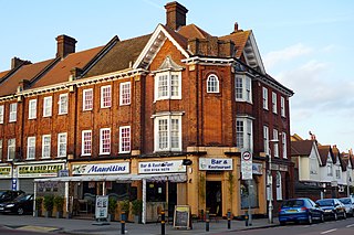
Thornton Heath is a district of South London, England, within the London Borough of Croydon. It is around 1.5 miles (2.4 km) north of the town of Croydon, and 7.2 miles (11.6 km) south of Charing Cross. Prior to the creation of Greater London in 1965, Thornton Heath was in the County Borough of Croydon.

The A23 road is a major road in the United Kingdom between London and Brighton, East Sussex, England. It is managed by Transport for London for the section inside the Greater London boundary, Surrey County Council and West Sussex County Council for the section shadowed by the M23 motorway, National Highways between the M23 and Patcham, and by Brighton and Hove Council from the A27 to the centre of Brighton.

The Croydon Canal ran 9+1⁄4 miles (15 km) from Croydon, via Forest Hill, to the Grand Surrey Canal at New Cross in south London, England. It opened in 1809 and closed in 1836, the first canal to be abandoned by an Act of Parliament.

The River Wandle is a right-bank tributary of the River Thames in south London, England. With a total length of about 9 miles (14 km), the river passes through the London boroughs of Croydon, Sutton, Merton and Wandsworth, where it reaches the Thames. A short headwater – the Caterham Bourne – is partially in Surrey, the historic county of the river's catchment. Tributaries of the Wandle include Carshalton Ponds and Norbury Brook.
Norbury is an area of south London. It shares the postcode London SW16 with neighbouring Streatham. Norbury is 6.7 miles (10.8 km) south of Charing Cross.

Croydon North is a constituency represented in the House of Commons of the UK Parliament since 2012 by Steve Reed of Labour Co-op. The seat was created in 1918 and split in two in 1955 and re-devised in a wholly different form in 1997.

The London Borough of Croydon has over 120 parks and open spaces within its boundaries, ranging from the 200 acre (80ha) Selsdon Wood Nature Reserve to many recreation grounds and sports fields scattered throughout the Borough. Croydon covers an area of 86.52 km², the 256th largest district in England. Croydon's physical features consist of many hills and rivers that are spread out across the borough and into the North Downs, Surrey and the rest of South London. Some of the open spaces in Croydon form part of the well-known London LOOP walks where the first section was opened on 3 May 1996 with a ceremony on Farthing Downs in Coulsdon. As a borough in Outer London it also contains some open countryside in the form of country parks. Croydon Council is associated with several other boroughs who are taking part in the Downlands Countryside Management Project. These boroughs are Sutton; and by Surrey County Council; the City of London Corporation; the Surrey districts of Reigate and Banstead and Tandridge; and the Countryside Agency. An additional partner is Natural Britain.
Croydon North West was a borough constituency represented in the House of Commons of the Parliament of the United Kingdom. It elected one Member of Parliament (MP) by the first past the post system of election.

The Norwood Ridge is a 10-square-mile (26 km2) rectangular upland which occupies the geographical centre of south London, centred 5 miles (8 km) south of London Bridge. Beneath its topsoil it is a ridge of London Clay that is capped on all sides with remaining natural gravel deposits mixed with some sandy soil, which in the South Thames basin is a material known as the Claygate Beds.

The River Bourne is the name given to a Thames tributary in northwest Surrey, England which has a longer tributary, the Windle Brook, that rises nears Bagshot Park in the south of Swinley Forest, Berkshire, merging with it while flowing through villages north of Woking; downstream the Bourne joins the Thames near Weybridge.
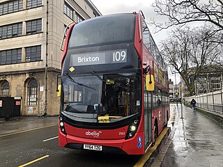
London Buses route 109 is a Transport for London contracted bus route in London, England. Running between Croydon and Brixton station, it is operated by Abellio London.
Heavers Meadow is a meadow located in South Norwood and Selhurst in the London Borough of Croydon. South Norwood Recreation Ground is on the other side of the road. The meadow covers an area of 83⁄4 acres. With meadows there are not usually many facilities. Heavers is no exception; the only facility stated on the council's website is a footpath through a flood meadow.

Pollards Hill is a small residential district straddling the south London boroughs of Croydon and Merton between Mitcham, Norbury and Thornton Heath. The boundary of the two boroughs is a street named Recreation Way. No roads directly cross the Croydon/Merton divide, and streets were planned according to each borough, leading to differing architectural or building schemes. Pollards Hill lends its name to a ward of the London Borough of Merton.

The Falconbrook was a stream that rose in Balham and Tooting, draining much of those parishes then the south and west of the larger district of Battersea including Clapham Junction to enter the London reaches of the Thames. Before doing so, it briefly formed the border of Wandsworth Town, reflected in the SW11/SW18 boundary today.
Eastfields is an area of South London situated between Mitcham and Streatham. The area is home to St Mark's Academy secondary school and to Mitcham Eastfields railway station, which opened on 2 June 2008. The area has two council estates, Laburnum and Eastfields Estate, 5 minutes away from each other. The area is covered by the postcodes CR4 and SW16.

The London to Brighton Way, also called the London to Portslade Way, is a Roman road between Stane Street at Kennington Park and Brighton in Sussex. The road passes through Streatham and Croydon, then through the Caterham Valley gap in the North Downs. It passes through Godstone and Felbridge, then follows an almost straight line through Ardingly, Haywards Heath, Burgess Hill and Hassocks to the South Downs at Clayton. At Hassocks it crosses the Sussex Greensand Way at a large Roman cemetery. It climbs the South Downs escarpment, crossing the ridgeway and connecting with other local tracks. South of Pyecombe the route is uncertain, and may have continued to Brighton or to Portslade.
Thornton Heath is an area of South London, England, and makes up a part of the London Borough of Croydon.

On 29 November 2012, a by-election was held for the UK House of Commons constituency of Croydon North in the London Borough of Croydon. The by-election was caused by the death of its Member of Parliament Malcolm Wicks. It took place on the same day as by-elections in Middlesbrough and Rotherham. The by-election was won by Steve Reed of the Labour Party.
