Blakenall Heath

Last updated

Blakenall Heath
Blakenall Lane, Blakenall Heath - geograph.org.uk - 1213597.jpg
Blakenall Lane, Blakenall Heath
West Midlands UK location map.svg
Red pog.svg
Blakenall Heath
Location within the West Midlands
Population12,022 (2011.Blakenall Ward) [1]
OS grid reference SK004018
Metropolitan borough
Metropolitan county
Region
Country England
Sovereign state United Kingdom
Post town Walsall
Postcode district WS3
Police West Midlands
Fire West Midlands
Ambulance West Midlands
UK Parliament
List of places
UK
England
West Midlands
52°36′51″N1°59′36″W / 52.6141°N 1.9934°W / 52.6141; -1.9934


Blakenall Heath is a suburban village in the Metropolitan Borough of Walsall in the West Midlands County, England. It straddles the border of Walsall and Bloxwich. Historically the village was a part of Staffordshire. It was originally a rural area between Walsall and Bloxwich with a small amount of private housing as recently as the beginning of the 20th century, but the area began to change dramatically after the end of the Great War. [2]

Farmland gave way to council housing, which surrounded the local church and a few pre-1914 buildings, and further developments took place over the next few decades. Walsall borough's first council house was completed in Blakenall Heath, on Blakenall Lane, in June 1920. Within seven years, 500 council houses had been built in the area, and by 1939 around 2,000 new council houses had been built in the Blakenall Heath, Harden, Coal Pool and Goscote areas. Several hundred more had followed by the 1970s, including three tower blocks of flats which were built in the late 1950s, as well as maisonettes in Walker Road which were built in the 1960s but quickly became unpopular with tenants as well as proving a magnet for crime, and were in demolished in 1985. [3]

The early council housing developments were divided between established neighbourhoods including Blakenall Lane and Harden Road, and new housing estates with themed street names; including the 1930s Poet's Estate at Harden (where road names included Shakespeare Crescent, Goldsmith Road and Tennyson Road) and the Green Rivers Estate at Blakenall Heath itself (where road names included Thames Road, Wye Road and Mersey Road) which was built in the 1940s and 1950s. [4]

Blakenall Heath is the centre of the Blakenall ward of Walsall, which has traditionally had some of the highest poverty and crime rates in the Metropolitan Borough of Walsall. Blakenall also includes neighbouring Harden, Goscote and Coal Pool. [5]

Between 2001 and 2006, some of the council housing around Blakenall Heath was demolished, including the whole of Taylor Avenue, the three late 1950s tower blocks, and large sections of Walker Road and Barracks Lane. Demolition has also taken place in neighbouring Harden and Goscote. New housing for the public and private sector has since been built in the place of the demolished council houses and flats. [6]

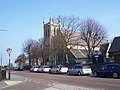
The parish church for Blakenall Heath is Christ Church, which is constructed from limestone and opened in 1872. [7]

Related Research Articles

<span class="mw-page-title-main">Walsall</span> Market town in West Midlands County, England

Walsall is a market town and administrative centre in the West Midlands County, England. Historically part of Staffordshire, it is located 9 miles (14 km) north-west of Birmingham, 7 miles (11 km) east of Wolverhampton and 9 miles (14 km) from Lichfield.

<span class="mw-page-title-main">Tipton</span> Town in the West Midlands, England

Tipton is an industrial town in the Metropolitan Borough of Sandwell in the West Midlands County in England. It had a population of 38,777 at the 2011 UK Census. It is located northwest of Birmingham and southeast of Wolverhampton. It is also contiguous with nearby towns of Darlaston, Dudley, Wednesbury and Bilston.

<span class="mw-page-title-main">Willenhall</span> Human settlement in England

Willenhall is a historic market town and civil parish in the Metropolitan Borough of Walsall, and partly in Wolverhampton, in the West Midlands, England, with a population taken at the 2011 census of 28,480. It is situated between Wolverhampton and Walsall, historically in the county of Staffordshire. It lies upon the River Tame, and is part of the Black Country.

<span class="mw-page-title-main">Bloxwich</span> Town in West Midlands, England

Bloxwich is a market town and civil parish in the Metropolitan Borough of Walsall, West Midlands, England. It is located between the towns of Walsall, Cannock, Willenhall and Brownhills.

Leamore is a suburb of Bloxwich and Walsall in Metropolitan Borough of Walsall, West Midlands County, England. It is a mix of private and council housing built since the late 19th century. The most significant homes in the area are several multi-storey blocks of council flats, which were built in the 1960s.

New Invention is a large estate around three miles (4.8 km) north of the town of Willenhall and four miles (6.4 km) east of the city of Wolverhampton in the Metropolitan Borough of Walsall, West Midlands, England. It is halfway between Walsall and Wolverhampton on the busy main A4124 and A462 roads.

Harden is an area to the north of Walsall and borders with Bloxwich, Blakenall Heath, Coalpool, Goscote and Rushall. The whole area was part of the industrial revolution, with mining and metal processing being the main industries. Although close to the A34 main road from the Stoke (potteries) to Birmingham, it is still served by canals.

<span class="mw-page-title-main">Pelsall</span> Human settlement in England

Pelsall is a village and civil parish in the Metropolitan Borough of Walsall, West Midlands, England. Forming part of the borough's border with Staffordshire, Pelsall is located 4 miles north of Walsall, midway between the towns of Bloxwich and Brownhills and 4 miles northwest of Aldridge. The southern edge of Cannock Chase is 6 miles to the north. Pelsall is also 8 miles southwest of Lichfield and 8 miles northeast of Wolverhampton.

Coal Pool is a housing estate in Walsall, West Midlands, England. Most of the homes in area were built by the local council during the 1930s, with a smaller development taking place in the late 1940s which marked the resumption of council house building in the borough after World War II.

<span class="mw-page-title-main">Landywood</span> Village in Staffordshire, England

Landywood is a village in the South Staffordshire district of Staffordshire, England. Landywood is part of the South Staffordshire ward named "Great Wyrley Landywood", It lies 3 miles north of Bloxwich, 3 miles south from Cannock and 6 miles north of Walsall.

<span class="mw-page-title-main">Rushall railway station (England)</span> Former railway station in England

Rushall railway station was a station serving the villages of Blakenall Heath and Rushall in the Metropolitan Borough of Walsall, England. It was on the South Staffordshire Line between Walsall and Lichfield.

<span class="mw-page-title-main">Rushall, West Midlands</span> Suburban Village in Walsall, West Midlands, England

Rushall is a suburb in the Metropolitan Borough of Walsall in the West Midlands, England. It is centred on the main road between Walsall and Lichfield. It is mentioned in the Domesday Book but has mostly developed since the 1920s. Rushall was historically a part of the county of Staffordshire before it was incorporated with much of the old Aldridge-Brownhills Urban District into the modern-day Walsall district.

<span class="mw-page-title-main">Old Hill</span> Human settlement in England

Old Hill is a village in Rowley Regis in the metropolitan borough of Sandwell in the West Midlands, England, situated around 2 miles (3.2 km) north of Halesowen and 3 miles (4.8 km) south of Dudley. Initially a separate village it is now part of the much larger West Midlands conurbation.

Goscote is a residential area of Walsall in the West Midlands of England. The Goscote name dates back several centuries and as recently as the 1920s it was a largely rural area that had survived the recent Industrial Revolution which dramatically altered the face of the region.

Forest Comprehensive School was a secondary school located in Hawbush Road, Harden, Walsall, West Midlands, England.

The Lodge Farm estate is located in the area of Short Heath in the town of Willenhall, which is in the Metropolitan Borough of Walsall.

<span class="mw-page-title-main">Trolleybuses in Walsall</span>

The Walsall trolleybus system once served the town of Walsall, then in Staffordshire, but now in West Midlands, England. Opened on 22 July 1931, it gradually replaced the Walsall Corporation Tramways network.

The Walsall Silver Thread Tapestries are a set of eleven artworks, in the form of tapestries, designed by the artist Hunt Emerson in conjunction with the various communities of Walsall, England and hand stitched by local people there during 2016. They depict the people, places, history and wildlife of the towns and districts that, since 1974, have formed the Metropolitan Borough of Walsall.

References

  1. "Walsall Ward population 2011" . Retrieved 19 December 2015.
  2. "History of Blakenall Heath, in Walsall and Staffordshire". Vision of Britain. Vision of Britain. Retrieved 17 April 2022.
  3. "About Blakenall Heath". The Bloxwich Telegraph - incorporating The Bloxidge Tallygraph and Walsall North News. Founded 2006. 28 September 2011. Retrieved 17 April 2022.
  4. "Blakenall Heath, Staffordshire - genealogy heraldry and history". ukga.org. Retrieved 17 April 2022.
  5. "Deprivation". Walsall Insight. Retrieved 17 April 2022.
  6. "300 homes plan for former Walsall estate left empty for years". www.expressandstar.com. Retrieved 17 April 2022.
  7. "About Blakenall Heath". The Bloxwich Telegraph - incorporating The Bloxidge Tallygraph and Walsall North News. Founded 2006. 28 September 2011. Retrieved 17 April 2022.