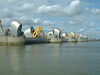
The Thames Barrier is a retractable barrier system built to protect the floodplain of most of Greater London from exceptionally high tides and storm surges moving up from the North Sea. It has been operational since 1982. When needed, it is closed (raised) during high tide; at low tide, it can be opened to restore the river's flow towards the sea. Built about 2 miles east of the Isle of Dogs, its northern bank is in Silvertown in the London Borough of Newham and its southern bank is in the New Charlton area of the Royal Borough of Greenwich.
Blackheath is an area in Southeast London, straddling the border of the Royal Borough of Greenwich and the London Borough of Lewisham. Historically within the county of Kent, it is located 1-mile (1.6 km) northeast of Lewisham, 1.5 miles (2.4 km) south of Greenwich and 6.4 miles (10.3 km) southeast of Charing Cross, the traditional centre of London.

Kidbrooke is an area of south-east London, England, in the Royal Borough of Greenwich 7+1⁄2 miles (12 km) south-east of Charing Cross and north west of Eltham.

Woolwich is a town in southeast London, England, within the Royal Borough of Greenwich.

Lewisham is an area of southeast London, England, six miles south of Charing Cross. It is the principal area of the London Borough of Lewisham, and was within the historic county of Kent until 1889. It is identified in the London Plan as one of 35 major centres in Greater London, with a large shopping centre and street market. Lewisham had a population of 60,573 in 2011.

Eltham is a district of southeast London, England, within the Royal Borough of Greenwich. It is 8.7 miles (14.0 km) east-southeast of Charing Cross, and is identified in the London Plan as one of 35 major centres in Greater London. The three wards of Eltham North, South and West have a total population of 35,459. 88,000 people live in Eltham.

Castle Vale is a housing estate located between Erdington, Minworth and Castle Bromwich. Currently Castle Vale makes up the Castle Vale Ward of Birmingham City Council which is part of Erdington constituency, 6 miles (9 km) northeast of Birmingham city centre in England. The area has an approximate population of 10,000 people and has a distinctly modern residential character stemming from its history as a postwar overspill estate.

The Big City Plan is a major development plan for the city centre of Birmingham, England.

Greenwich and Woolwich is a constituency represented in the House of Commons of the UK Parliament since 2015 by Matthew Pennycook of the Labour Party.

The Aylesbury Estate is a large housing estate located in Walworth, South East London.

Coin Street Community Builders (CSCB) is a development trust and social enterprise which seeks to make London's South Bank a better place in which to live, to work, to visit and to study. Since 1984 CSCB has transformed a largely derelict 13-acre site into a thriving mixed-use neighbourhood.

Roundshaw is a housing estate and park in south Wallington and Beddington on the eastern edge of the London Borough of Sutton. Grid Ref TQ302633.

Ravenscraig is a housing development and historic village located in North Lanarkshire, Scotland, one point five miles north-east of central Motherwell. Ravenscraig was formerly the site of Ravenscraig steelworks; once the largest hot strip steel mill in western Europe, the steelworks closed in 1992, and is now almost totally demolished. After over two decades of lying derelict, the empty land was redeveloped in the 2010s, with new houses and amenities being constructed on a large scale, with construction still ongoing into the 2020s. The main contributors to this project were Wilson Bowden Developments Ltd, Scottish Enterprise and Tata Steel Europe.

Fitzroy Place is an office, residential and retail estate in Fitzrovia, London. With 289 homes, interiors designed by Johnson Naylor, and 220,000 square feet (20,000 m2) of office space, Fitzroy Place houses a series of shops, restaurants, offices and community spaces set around a publicly accessible central square. The square, which was the first new garden square in the W1 area for 100 years, incorporates the Grade II* listed Fitzrovia Chapel.

Lifschutz Davidson Sandilands is a practice of architects, urban designers and masterplanners established in 1986 and practising out of London.

The Heygate Estate was a large housing estate in Walworth, Southwark, South London, comprising 1,214 homes. The estate was demolished between 2011 and 2014 as part of the urban regeneration of the Elephant & Castle area. Home to more than 3,000 people, it was situated adjacent to Walworth Road and New Kent Road, and immediately east of the Elephant & Castle road intersection. The estate was used extensively as a filming location, due in part to its brutalist architecture.
Blackheath Bluecoat Church of England School was a secondary school and sixth form located in the Blackheath Standard area of Blackheath, in the Royal Borough of Greenwich. Its closure was announced in January 2012 and the school formally closed at the end of August 2014.
Orchard Village, formerly known as the Mardyke Estate, is a housing development in the South Hornchurch area of London, England.

Neil Biron Rhind was an English journalist, writer and an authority on the social and historical development of Blackheath and surrounding areas of south-east London.

Kidbrooke Village is a residential development located in the Kidbrooke area of the Royal Borough of Greenwich, in London, England. It is part of a larger regeneration project aimed at transforming the former Ferrier Estate into a new, mixed-use community. The development is a collaborative effort involving the local government, housing developers, and community stakeholders.


