
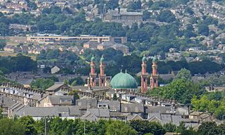
Castleford is a town within the City of Wakefield district, West Yorkshire, England. It had a population of 45,106 at a 2021 population estimate. Historically in the West Riding of Yorkshire, to the north of the town centre the River Calder joins the River Aire and the Aire and Calder Navigation. It is located north east of Wakefield, north of Pontefract and south east of Leeds. Castleford is the largest town in the Wakefield district after Wakefield itself.

Selby District was a local government district of North Yorkshire, England, from 1974 to 2023. Its council was based in the town of Selby. The district had a population of 83,449 at the 2011 Census. The southernmost district of North Yorkshire, it bordered the City of York unitary authority, the Borough of Harrogate in North Yorkshire, the City of Leeds and City of Wakefield districts in West Yorkshire, the City of Doncaster in South Yorkshire, and the ceremonial county of the East Riding of Yorkshire.

Wakefield, commonly known as the City of Wakefield, is a local government district with the status of a city and metropolitan borough in West Yorkshire, England. Wakefield, the largest settlement, is the administrative centre of the district. The population of the City of Wakefield at the 2011 Census was 325,837. The district includes the Five Towns of Castleford, Featherstone, Knottingley, Normanton and Pontefract. Other towns include Hemsworth, Horbury, Ossett, South Elmsall and South Kirkby. The city and district are governed by Wakefield Council from the County Hall.

Woolley Colliery is a village on the border between the Barnsley and Wakefield districts in Yorkshire, England. The village is now in South Yorkshire, while the former colliery was in the Wakefield Rural Ward in West Yorkshire. The village is known locally as Mucky Woolley, as a tribute to its coalmining heritage and to distinguish it from the more affluent village of Woolley two miles away.
Osgoldcross Rural District was a rural district in the West Riding of Yorkshire, England. It was created in 1938, from 19 remaining parishes of the disbanded Pontefract Rural District after three-quarters of its population had been transferred to surrounding authorities - specifically to Castleford, Knottingley, and Pontefract.


The West Yorkshire Built-up Area, previously known as the West Yorkshire Urban Area is a term used by the Office for National Statistics (ONS) to refer to a conurbation in West Yorkshire, England, based on the cities of Leeds, Bradford and Wakefield, and the large towns of Huddersfield and Halifax. It is the 4th largest urban area in the United Kingdom. However, it excludes other towns and villages such as Featherstone, Normanton, Castleford, Pontefract, Hemsworth, Todmorden, Hebden Bridge, Knottingley, Wetherby and Garforth which, though part of the county of West Yorkshire are considered independently. There are substantial areas of agricultural land within the designated area – more than in any other official urban area in England – many of the towns and cities are only just connected with one another by narrow outlying strips of development.
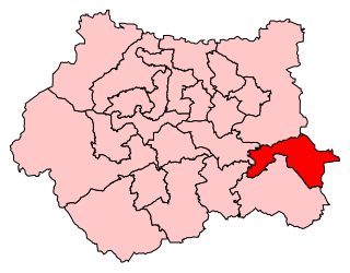
Normanton, Pontefract and Castleford is a constituency in West Yorkshire represented in the House of Commons of the UK Parliament by Yvette Cooper of the Labour Party since its 2010 creation. Cooper has served under the governments of Tony Blair and Gordon Brown alongside her husband Ed Balls, and served as Shadow Home Secretary under the leadership of Ed Miliband. Having served as chair of the Home Affairs Select Committee, she is once again the Shadow Home Secretary.

Osgoldcross was a wapentake of the West Riding of Yorkshire, England. It included the parishes of Adlingfleet, Badsworth, Burghwallis, Campsall, Castleford, Darrington, Kellington, South Kirkby, Owston, Pontefract, Whitgift, Womersley, Ferry Fryston and parts of Featherstone, Snaith and Wragby.

Ferry Fryston is a suburb of the town of Castleford in West Yorkshire, England. It is situated in the metropolitan borough of the City of Wakefield. The appropriate ward is called Airedale and Ferry Fryston.

New Fryston is a small former coal mining village in Castleford, West Yorkshire, England, located in a river bend on the south bank of the River Aire.

The Municipal Borough of Castleford was a local government district in the West Riding of Yorkshire from 1955 to 1974 around the town of Castleford, covering Airedale, New Fryston, Whitwood, Cutsyke, Glasshoughton and Whitwood. The Castleford Urban District administered the town from 1894 to 1955.

Wheldale Colliery was a coal mine located in Castleford, Yorkshire, England which produced coal for 117 years. It was accessed from Wheldon Road.

Fryston Hall was a country house at Water Fryston, West Yorkshire which stood in an estate between the town of Castleford and the River Aire near where the river is crossed by the A1(M). The main building was demolished in 1934 and only some outbuildings survive as farm buildings.
Airedale and Ferry Fryston is an electoral ward of the City of Wakefield district used for elections to Wakefield Metropolitan District Council.
Pontefract, Castleford and Knottingley is a proposed constituency of the House of Commons in the UK Parliament. Further to the completion of the 2023 Periodic Review of Westminster constituencies, it will first be contested at the next general election. Yvette Cooper is the incumbent MP for all parts of this new seat.

