Drumchapel

Last updated

Drumchapel
Drumchapel houses from 15 Linkwood Crescent.JPG
Drumchapel housing photographed from the tower blocks at Linkwood Crescent (2014)
Glasgow UK location map.svg
Red pog.svg
Drumchapel
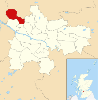
Location within Glasgow
Population12,976 
OS grid reference NS525705
Council area
Lieutenancy area
  • Glasgow
Country Scotland
Sovereign state United Kingdom
Post town GLASGOW
Postcode district G15
Dialling code 0141
Police Scotland
Fire Scottish
Ambulance Scottish
UK Parliament
Scottish Parliament
List of places
UK
Scotland
Glasgow
55°54′18″N4°21′39″W / 55.904937°N 4.360965°W / 55.904937; -4.360965

Drumchapel (Scottish Gaelic : Druim a' Chapaill), known locally as 'The Drum', is a district in the north-west of the city of Glasgow, Scotland. It borders Bearsden (in East Dunbartonshire) to the north-east and Drumry (part of Clydebank, in West Dunbartonshire) to the south-west, as well as Blairdardie, Garscadden, Knightswood and Yoker in Glasgow to the south; land to the north (including the Garscadden Woodlands) is undeveloped and includes the course of the Roman-era Antonine Wall. The name derives from the Gaelic meaning 'the ridge of the horse'.

Contents

As part of the overspill policy of Glasgow Corporation, a huge housing estate was built here in the 1950s to house 34,000 people, the land having been annexed from Dunbartonshire in 1938 – it is this estate that is now most associated with Drumchapel, despite there already being a neighbourhood to the south of Drumchapel railway station known by the same name, made up of affluent suburban villas; this is now known as Old Drumchapel.

Drumchapel is one of the 'Big Four' post-war social housing schemes in Glasgow, along with Easterhouse, Castlemilk and Greater Pollok. All are similar in terms of architecture and planning, and have tended to suffer from a similar range of enduring social problems, notably anti-social behaviour and degeneration of often poorly constructed post-war housing. However, the area remains popular with many of its residents and more recently there has been substantial private investment including the construction of new housing developments in the north-west of the district.

History

Aerial view of central Drumchapel (2017), with the local secondary school surrounded by expanses of unused land following the demolition of substandard housing, with modern houses and refurbished tenements also in view Drumchapel from the air (geograph 5310333).jpg
Aerial view of central Drumchapel (2017), with the local secondary school surrounded by expanses of unused land following the demolition of substandard housing, with modern houses and refurbished tenements also in view

Drumchapel was part of the parish of New Kilpatrick, becoming devolved in the late 19th century and a church parish in its own right in 1923. The Old Church (originally serving both Drumchapel and Blairdardie) was built in 1901 for an increasing local population. [1] The parish boundary was redrawn to create the new parish of St Margarets in Knightswood. [2]

Civil administration transferred from New Kilpatrick to Glasgow Corporation in 1938. As part of the overspill policy of Glasgow Corporation, a huge housing estate was built here in the 1950s. [3] [4]

The area suffered a tragedy in 1994 when a double-decker bus carrying a group of local Girl Guides crashed into one of the low rail bridges in the city's Tradeston area (the driver was unfamiliar with the route and was being led by a guide leader in a car); two 10-year-old girls, an 11-year-old girl and two adult supervisors were killed in the incident and 15 other children injured, six of them seriously. [5] [6] [7] [8] [9]

Geography

Linkwood Crescent tower blocks (two refurbished in the 2010s, one demolished) 27 Linkwood Crescent.JPG
Linkwood Crescent tower blocks (two refurbished in the 2010s, one demolished)

The housing in the area is now 72% post-war tenement and 6% multi-storey flats, the remainder being other flats and houses. The current population was estimated in 2002 at 15,000, which was split across 6,000 households. [10] The population of Drumchapel fell by 22% between 1996 and 2012 to 13,000. The proportion of people in the area from ethnic minority groups increased over the same time to 5%, which remains well below average for Glasgow (12%). Life expectancy in the area is about five years less than the average for Glasgow (male 69 years, female 74 years). [11]

Socio-economically, the area is not affluent. In 2011/12, 48% of children were classed as living in poverty, and 57% of the population were NRS social grade D or E. 56% of households were single-parent. 21% of young people were not in education, employment or training. Just 22% of the population own their own home, about half the average figure for Glasgow. [11]

Economy

The derelict shopping centre at Drumchapel Drumchapel shopping centre - geograph.org.uk - 362945.jpg
The derelict shopping centre at Drumchapel
Whisky bond barrels and tenements on Heathcot Ave Barrels of whisky - geograph.org.uk - 667439.jpg
Whisky bond barrels and tenements on Heathcot Ave

The major employers for Drumchapel from the 1950s to the 1980s were the Goodyear Tyre & Rubber Co (GB) Ltd, Beattie's Biscuit Factory, Singers Sewing Machines (Clydebank), The Edrington Group Whisky Bond and the various shipyards on the Clyde. Beattie's Biscuit factory closed in 1978 and the Goodyear and Singers factories both closed in February 1979.

The Edrington Group Whisky Bond has grown over the years and is still a major employer in the area, while the shipyards have all gone with the exception of the now BAE Systems yards at Scotstoun and Govan. Drumchapel is now going through its second regeneration, with promises of better schools, better homes and higher employment. [12]

Notable residents

See also

Related Research Articles

<span class="mw-page-title-main">Dunbartonshire</span> Historic county in Scotland

Dunbartonshire or the County of Dumbarton is a historic county, lieutenancy area and registration county in the west central Lowlands of Scotland lying to the north of the River Clyde. Dunbartonshire borders Perthshire to the north, Stirlingshire to the east, Lanarkshire and Renfrewshire to the south, and Argyllshire to the west.
<span class="mw-page-title-main">Clydebank</span> Town in Scotland

Clydebank is a town in West Dunbartonshire, Scotland. Situated on the north bank of the River Clyde, it borders the village of Old Kilpatrick to the west, and the Yoker and Drumchapel areas of the adjacent City of Glasgow immediately to the east. Depending on the definition of the town's boundaries, the suburban areas of Duntocher, Faifley and Hardgate either surround Clydebank to the north, or are its northern outskirts, with the Kilpatrick Hills beyond.
<span class="mw-page-title-main">Bearsden</span> Town in East Dunbartonshire, Scotland

Bearsden is a town in East Dunbartonshire, Scotland, on the northwestern fringe of Greater Glasgow, approximately six miles from the city centre.

<span class="mw-page-title-main">Knightswood</span> Human settlement in Scotland

Knightswood is a suburban district in Glasgow, containing three areas: Knightswood North or High Knightswood, Knightswood South or Low Knightswood, and Knightswood Park. It has a golf course and park, and good transport links with the rest of the city. Garscadden and Scotstounhill railway stations serve Low Knightswood while Westerton station serves High Knightswood. Knightswood is directly adjoined by the Anniesland, Blairdardie, Drumchapel, Garscadden, Jordanhill, Netherton, Scotstoun, Scotstounhill and Yoker areas of Glasgow, and by Bearsden in the north.

<span class="mw-page-title-main">Temple, Glasgow</span> Human settlement in Scotland

Temple is a neighbourhood of Glasgow located in the north of the city, bounded by Anniesland to the south, Knightswood to the west and Kelvindale to the east; Netherton lies to the north. Temple appears in Joan Blaeu's 1662 Atlas of Scotland and many subsequent maps.

<span class="mw-page-title-main">Old Kilpatrick</span> Village in West Dunbartonshire, Scotland

Old Kilpatrick, is a village in West Dunbartonshire, Scotland. The name Old Kilpatrick is said to be derived from St. Patrick ostensibly being born here. It has an estimated population of 4,820. It belonged to the parish of Old Kilpatrick which itself was only a few thousand people strong.
<span class="mw-page-title-main">Blairdardie</span> Human settlement in Scotland

Blairdardie is a neighbourhood in the Scottish city of Glasgow. It is situated north of the River Clyde in the north-west of the city and is surrounded by other residential areas: High Knightswood, Knightswood, Old Drumchapel, Drumchapel and Garscadden. It was built between the 1950s and early 1960s.

<span class="mw-page-title-main">Tradeston</span> District of Glasgow, Scotland

Tradeston is a small district in the Scottish city of Glasgow adjacent to the city centre on the south bank of the River Clyde. The name reflected its role as a primarily dockland area with a large number of warehouses and wharves along the riverside were vessels would be unloaded. It merges to the south and west with Kingston, and the two districts are often considered one and the same.

<span class="mw-page-title-main">Bowling, West Dunbartonshire</span> Human settlement in Scotland

Bowling is a village in West Dunbartonshire, Scotland, with a population of 740 (2015).
<span class="mw-page-title-main">New Kilpatrick</span> Parish in Dunbartonshire, Scotland

New Kilpatrick, is an ecclesiastical Parish and former Civil Parish in Dunbartonshire. It was formed in 1649 from the eastern half of the parish of Kilpatrick, the western half forming Old Kilpatrick. New Kilpatrick is also a disused name for the town of Bearsden.

<span class="mw-page-title-main">Old Drumchapel</span> Human settlement in Scotland

Old Drumchapel is a neighbourhood of Glasgow, Scotland. It is located around Drumchapel railway station and formed part of the Cowdenhill and Garscadden Estates. It is situated to the south of the larger and newer Drumchapel housing estate, and to the north of the arterial Great Western Road running from Glasgow to Clydebank. The Blairdardie neighbourhood lies immediately to the east, while a retail park separates Old Drumchapel from the Linnvale and Drumry areas of Clydebank to the west.

<span class="mw-page-title-main">Drumry</span> Human settlement in Scotland

Drumry is a district in the Scottish town of Clydebank, West Dunbartonshire, split into North and South Drumry by its main thoroughfare, Drumry Road. Some of the housing, including five tower blocks, was refurbished in the early 2010s.

<span class="mw-page-title-main">Knightswood St Margaret's Parish Church</span> Church in Glasgow, Scotland

Knightswood St. Margaret's Parish Church is a parish church of the Church of Scotland, serving part of the Knightswood area of Glasgow, Scotland.

Duntocher Hibernian Football Club were a Scottish Junior football club from the village of Duntocher, West Dunbartonshire, who played in three spells over a period of 86 years. Based at Glenhead Park from 1929, the club colours were green with white sleeves.

<span class="mw-page-title-main">St Columba's High School, Clydebank</span> State school in Clydebank, West Dunbartonshire, Scotland

St Columba's High School was a Roman Catholic comprehensive school in Drumry, Clydebank, West Dunbartonshire, Scotland. It was one of two denominational schools in the town which merged in 2009 to become St Peter the Apostle High School. The school had an inspection by Her Majesty's Inspectorate of Education (HMIE) in 2006 and received positive results.

<span class="mw-page-title-main">Netherton, Glasgow</span> Human settlement in Scotland

Netherton is a district of Glasgow, in the north of the city, bounded by Temple to the south, Knightswood to the west while Westerton in Bearsden lies to the North and East. Netherton appears in Joan Blaeu's 1662 Atlas of Scotland and many subsequent old maps. It is currently not shown on Ordnance Survey maps greater than 1:25000 scale. The street was founded in around the 1930s. It is a street close by local shops, the hut, and a park district. Part of the city council.

<span class="mw-page-title-main">St Peter the Apostle High School</span> Comprehensive school in Clydebank, West Dunbartonshire, Scotland

St Peter the Apostle High School is a Roman Catholic high school in Drumry, Clydebank, Scotland. It was formed as an amalgamation of the former St Columba's High School and St Andrew's High School. St Peter the Apostle High School is one of two Roman Catholic secondary schools in West Dunbartonshire.

<span class="mw-page-title-main">Garscadden/Scotstounhill (ward)</span> Human settlement in Scotland

Garscadden/Scotstounhill is one of the 23 wards of Glasgow City Council. Since its creation in 2007 it has retained the same boundaries and returned four council members, using the single transferable vote system.
<span class="mw-page-title-main">Drumchapel/Anniesland (ward)</span> Human settlement in Scotland

Drumchapel/Anniesland is one of the 23 wards of Glasgow City Council. Since its creation in 2007 it has retained the same boundaries and returned four council members, using the single transferable vote system.

<span class="mw-page-title-main">Drumchapel St Andrew's Church</span> Church in Glasgow, Scotland

Drumchapel St Andrew's Church is a 20th-century parish church of the Church of Scotland located in the Old Drumchapel area of Glasgow. The church is sometimes referred to as the "White Church" due to its white painted walls.

References

  1. Kilpatrick Parish Archived 10 May 2010 at the Wayback Machine
  2. McCardel, J (1949). The Parish of New Kilpatrick. University Press Glasgow.
  3. Drumchapel, 1954, Virtual Mitchell
  4. "Modern Times: 1950s to The Present Day: Neighbourhoods: Drumchapel". The Glasgow Story.
  5. "Bus crash toll rises to five as girl dies". The Herald. 28 September 1994.
  6. Macintyre, Donald (22 March 1995). "Anger at verdict over Guides death crash". The Independent.
  7. "I still blame myself for Cath's death: Tormented bus crash victim's mum tells court of agony". Daily Record. 21 October 1998 via The Free Library.
  8. "Drumchapel Girl Guides tragedy remembered 20 years on". Clydebank Post. 24 September 2014.
  9. "Judgement: Joseph Munro McKnight and Mrs Joan McKnight v. Clydeside Buses Limited and Glasgow City Council and Railtrack Plc and Mima Dunlop". Scottish Courts Service. 23 December 1998.
  10. Glasgow City Council: Drumchapel Area Housing Plan 2002
  11. 1 2 "Drumchapel". Understanding Glasgow. Glasgow Centre for Population Health. Retrieved 16 March 2015.
  12. The History of Drumchapel Archived 4 June 2007 at the Wayback Machine
  13. 1 2 The Glasgow Girls 15 years on: How seven inspirational schoolgirls sparked Glasgow's social conscience, Glasgow Live, 8 August 2016. Retrieved 21 April 2022
  14. 22 Glasgow sites that helped Billy Connolly become a comedy legend. Glasgow Live, 1 December 2018. Retrieved 21 April 2022
  15. Chris Marshall and Carla Gray (7 May 2011). "Scottish Parliament election: Profiles of the candidates elected to serve in Edinburgh". Edinburgh Evening News . Archived from the original on 11 May 2011. Retrieved 7 May 2011.
  16. Andy Gray | Mitchell Library, Glasgow Collection, Bulletin Photographs. The Glasgow Story. Retrieved 21 April 2022
  17. Former Rangers hero Andy Gray on pitch battles with Graeme Souness and Kenny Dalglish and being voted the best player in England, Daily Record, 13 October 2018. Retrieved 21 April 2022
  18. "Kieron Smith, Boy, by James Kelman". Independent.co.uk . 24 April 2008.
  19. George Kerevan: Harsh lesson is children need to work harder, The Scotsman, 16 December 2011. Retrieved 21 April 2022
  20. 1 2 A love affair bordering on an obsession, The Herald, 17 August 1996. Retrieved 21 April 2022
  21. Christina McAnea elected UNISON general secretary, Unison, 11 january 2021. Retrieved 21 April 2022
  22. The family feud that haunts Atonement star James McAvoy, Evening Standard, 11 April 2012. Retrieved 21 April 2022
  23. Happy 70th birthday to Celtic legend, Danny McGrain. Celtic FC, 1 May 2020. Retrieved 21 April 2022
  24. "Sharon shows her ugly side; Stunning Scots actress Sharon Small has just won the role of an unlovely, fat detective. Some mistake, surely? - Free Online Library".
  25. Obituary: Gordon Melville Smith, footballer, The Scotsman, 14 April 2014. Retrieved 21 April 2022
  26. "Renfrewshire Provost Lorraine Cameron pays tribute to Tannahill Makar". Renfrewshire News. 28 January 2022. Archived from the original on 28 January 2022. Retrieved 21 April 2022.