Cardonald is an outlying suburb of the Scottish city of Glasgow. Formerly a village in its own right, it lies to the southwest of the city and is bounded to the south by the White Cart Water. The area was part of Renfrewshire until 1926 when the villages of Cardonald, Crookston, Halfway and their surrounding farmland were annexed to Glasgow.

East Renfrewshire is one of 32 council areas of Scotland. It was formed in 1996, as a successor to the Eastwood district of the Strathclyde region. The northeastern part of the council area is close to Glasgow and many of the council area's northern settlements fall into the Greater Glasgow urban area.

Renfrewshire is one of the 32 council areas of Scotland.

Nitshill is a district on the south side of Glasgow. It is bordered by South Nitshill to the south, Darnley to the east, Crookston and Roughmussel to the north-west, Hurlet to the west and Househillwood and Priesthill to the north, with the Pollok district and the Silverburn Centre beyond. An area of open ground to the south-west of Nitshill forms the boundary between Glasgow and the town of Barrhead in East Renfrewshire.

Pollok is a large housing estate on the south-western side of the city of Glasgow, Scotland. The estate was built either side of World War II to house families from the overcrowded inner city. Housing 30,000 at its peak, its population has since declined due to the replacement of substandard housing with lower-density accommodation. As of 2021, the population was recorded at 81,951 people.
Ralston is a small, middle-class, suburban settlement in Renfrewshire, Scotland, being part of the greater town of Paisley. The district straddles the A761, the main dual-carriageway between Renfrewshire and the City of Glasgow.

Barrhead is a town in East Renfrewshire, Scotland, thirteen kilometres (8 mi) southwest of Glasgow city centre on the edge of the Gleniffer Braes. At the 2011 census its population was 17,268.

Newton Mearns is a suburban town and the largest settlement in East Renfrewshire, Scotland. It lies 7 miles (11 km) southwest of Glasgow City Centre on the main road to Ayrshire, 410 feet (125 m) above sea level. It has a population of approximately 26,993, stretching from Whitecraigs and Kirkhill in the northeast to Maidenhill in the southeast, to Westacres and Greenlaw in the west and Capelrig/Patterton in the northwest.

Southpark Village is a housing estate in the Darnley area of the Scottish city of Glasgow. The northwestern area was built during the mid to late 1980s, but the southeastern part was built in the late 2010s. It is located on the south-western edge of the city, close to the towns of Barrhead and Newton Mearns in East Renfrewshire. Nearby areas within Glasgow itself are the rest of Darnley to the north, Deaconsbank to the east, and Parkhouse to the northwest, although Southpark is physically separated from all but the rest of Darnley by the Dams to Darnley Country Park and M77 motorway.

Netherlee is a suburban residential area in East Renfrewshire, Scotland. It is situated on the west bank of the White Cart Water about 4 miles (6.5 km) south of Glasgow city centre. Part of the Greater Glasgow conurbation, it is mostly contiguous with the city, and is just beyond the boundary of its local authority area. It is a separate census locality from Glasgow, like other areas such as neighbouring Giffnock and Clarkston. Netherlee is directly contiguous with Stamperland. It is also in a council ward with Clarkston and its neighbour Busby. As of 2012, Netherlee has a population of 4,550.
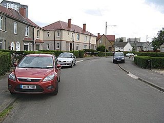
Crookston is a residential suburb on the southwestern edge of the city of Glasgow, Scotland.

The River Cart is a tributary of the River Clyde, Scotland, which it joins from the west roughly midway between the towns of Erskine and Renfrew and opposite the town of Clydebank.

South Nitshill is a neighbourhood in the Scottish city of Glasgow. It is situated south of the River Clyde, in the south-west of the conurbation and within the Greater Pollok ward of the local authority area. All streets in the area have names beginning with 'W'.

Neilston is a village and parish in East Renfrewshire in the west central Lowlands of Scotland. It is in the Levern Valley, two miles southwest of Barrhead, the last remaining town in greater Glasgow to operate trams, 3+3⁄4 miles south of Paisley, and 5+3⁄4 miles south-southwest of Renfrew, at the southwestern fringe of the Greater Glasgow conurbation. Neilston is a dormitory village with a resident population of just over 5,000 people.

Renfrewshire or the County of Renfrew is a historic county, registration county and lieutenancy area in the west central Lowlands of Scotland. The lieutenancy area covers the three modern council areas of Inverclyde, Renfrewshire and East Renfrewshire, and this area is occasionally termed Greater Renfrewshire to distinguish it from the modern council area called Renfrewshire. The historic county additionally included territory on the south-western edge of Glasgow which was gradually transferred to the administrative area of the city as it grew.

Deaconsbank is a neighbourhood in the Scottish city of Glasgow. It is situated south of the River Clyde. The main feature of the area, which falls into the Greater Pollok ward of Glasgow City Council and directly borders the East Renfrewshire council region, is an estate of around 639 private houses built in the late 1970s by Barratt Developments, prior to which the area was open farmland. Deaconsbank is bordered by the M77 motorway to the west and by Rouken Glen Park and golf course to the east. The northern parts of the suburban town of Newton Mearns are a short distance to the south, as is Patterton railway station.

The Levern Water, is a small river in East Renfrewshire and Glasgow, Scotland. It rises in the Long Loch, and flows generally north and east, past the towns of Neilston and Barrhead, for a total distance of 9 miles (14 km). It empties into the White Cart River.

Clarkston is a suburban town in East Renfrewshire, in the Central Lowlands of Scotland. A dormitory town with a population of around 10,000, Clarkston is on the southern fringe of the Greater Glasgow conurbation and directly adjoins the neighbouring suburban villages of Busby and Netherlee, as well as the towns of Newton Mearns and Giffnock.

Parkhouse is a residential neighbourhood of Glasgow, Scotland close to the border with East Renfrewshire. It is located on the south-western edge of the city, close to the towns of Barrhead and Newton Mearns in East Renfrewshire. Within the G53 postcode area and the Greater Pollok ward of the Glasgow City Council administration, the eastern cluster of private housing was constructed in the 1980s and the western part in the 2010s, prior to which it was open farmland annexed to Glasgow in 1938.

Rosshall is an area in the south-west of Glasgow, Scotland, within the Cardonald ward of Glasgow City Council. It has a fairly isolated location, with the White Cart Water forming a border to the south and east, the Paisley Canal Line railway to the north, and open fields to the west that form a short green belt between Glasgow and the large town of Paisley – the nearest building 500 yards (460 m) to the west, Rosshall Mains Farm, falls under Paisley administration rather than Glasgow.


