
Newport City Council is the governing body for Newport, one of the principal areas of Wales. It consists of 51 councillors, who represent the city's 20 wards.

Ammanford is a town and community in Carmarthenshire, Wales. At the 2021 census the community had a population of 5,445, and the wider built up area had a population of 8,285.
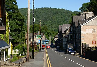
Betws-y-Coed is a village and community in the Conwy valley in Conwy County Borough, Wales, located in the historic county of Caernarfonshire, right on the boundary with Denbighshire, in the Gwydir Forest. It is now a very popular visitor destination in the Snowdonia National Park. The population of the community as of the 2021 census was 476, a decline on the previous census.

Newport East is a constituency in the city of Newport, South Wales, represented in the House of Commons of the UK Parliament since 2005 by Jessica Morden of the Labour Party.

Bettws Cedewain, also known as Bettws Cedewen, is a small village and community in Montgomeryshire, Powys, Wales. It lies in a sheltered valley on the banks of the River Bechan, some 3 miles (5 km) north of Newtown, on the B4389 road. The community is known as Betws Cedewain, and includes the hamlets of Highgate and Brooks.

Betws is a small village and community on the River Amman in Carmarthenshire, Wales, some 15 miles north of Swansea; it is part of the ecclesiastical parish of Betws and Ammanford, and the urban area of Ammanford. The nearby mountain, at the western end of the Black Mountain, is named after the village, and has a large area of common land.

St Julians is a community and coterminous electoral district (ward) of the City of Newport, South Wales.

Malpas is an electoral district (ward) and coterminous community (parish) of the city of Newport, South Wales. The area is governed by the Newport City Council.

Bettws-y-Crwyn is a small, remote village and civil parish in south-west Shropshire, England. It is close to the England–Wales border and is one of a number of English villages to have a Welsh language placename.
Malpas is a market town and a civil parish in the unitary authority of Cheshire West and Chester and the ceremonial county of Cheshire, England. It lies near the borders with Shropshire and Wales, and had a population of 1,673 at the 2011 census.
Rumney is a district and community in the east of the city of Cardiff, Wales. It lies east of the Rhymney River, and was historically part of Monmouthshire. On 1 April 1938 the Cardiff Extension Act 1937 incorporated it into the county borough of Cardiff, although it became part of Glamorganshire in the 1880's.
Pontprennau is a ward and community in the north of the city of Cardiff, Wales, lying north of Pentwyn and Cyncoed, between the village of Old St Mellons and the farmlands east of Lisvane. The community had a population of 7,353 in 2011.
Marshfield is a village and community of Newport, Wales. It sits approximately 5 miles southwest of Newport, and 7 miles northeast of Cardiff. The area is governed by Newport City Council. The community includes Castleton. Its population in 2011 was 3,054.

Crindau is a Victorian inner-city area just north of the city centre in Newport in south-east Wales. It lies within the Shaftesbury electoral district (ward) and community (parish).

Betws yn Rhos is a village and community in Conwy County Borough, Wales.
Bettws, is a small ex-mining and farming village in the South Wales Valleys in the county borough of Bridgend, Wales. Bettws is also an electoral ward for the county council.

Tredegar Park is a community of the city of Newport. It is named after the nearby park, although the community covers a much smaller area.

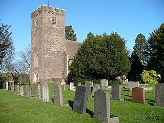
Bettws Newydd is a small village in Monmouthshire, in southeast Wales located about 3+1⁄2 miles (5.6 km) north of Usk, a few miles south of Clytha near Raglan, Monmouthshire.
The Newport Deanery is a Roman Catholic deanery in the Archdiocese of Cardiff that covers several churches in Newport and Monmouthshire, Wales.

The Church of St Mark is a Church in Wales (Anglican) church located on Gold Tops, in the Allt-yr-yn area of Newport, Wales. It is a Newport landmark and is part of the Newport North West Ministry Area.


