Penhow

Last updated

Penhow
St John's church, Penhow - geograph.org.uk - 6020671.jpg
Church of St John the Baptist
Newport UK location map.svg
Red pog.svg
Penhow
Location within Newport
Population744  (2011 census [1] )
Principal area
Country Wales
Sovereign state United Kingdom
Post town CALDICOT
Postcode district NP26
Dialling code 01633
Llanwern and Penhow exchanges
Police Gwent
Fire South Wales
Ambulance Welsh
UK Parliament
Senedd Cymru – Welsh Parliament
List of places
UK
Wales
Newport

51°36′54″N2°50′06″W / 51.61513°N 2.83497°W / 51.61513; -2.83497

Contents

Wales Newport Community Penhow map.svg
Map of the community

Penhow (Welsh : Pen-hw) is a small village, historic parish and community just inside the eastern edge of the boundary of the city of Newport, South Wales, within the historic county of Monmouthshire. The name Penhow is believed to be derived from the Welsh word pen meaning 'head' or 'top' and how from the Old English 'projecting ridge' in its dative form hōh 'place at the ridge'. [2] The community includes the estate of Parc-Seymour. The Penhow Woodlands National Nature Reserve lies a short distance to the south of the village.

Penhow Quarry is operated by Hanson plc.

History and architecture

Roman remains

Fragments of Roman building material have been found in the area. [3] These include evidence of a Roman building at Llanvaches, an artefact at Penhow, and a Roman road at Parc-Seymour. [4]

Penhow Castle

Penhow castle viewed from the parish church Penhow castle in 2002.JPG
Penhow castle viewed from the parish church
Recreation of seal reportedly used by Roger de Seymour (died c. 1299) of Undy and Penhow Castle, as reported by the Duchess of Cleveland in her Battle Abbey Roll (1889), showing the Seymour arms, the "Vol", Gules, two wings conjoined in lure or RogerDeSeymour Seal Circa1299.png
Recreation of seal reportedly used by Roger de Seymour (died c. 1299) of Undy and Penhow Castle, as reported by the Duchess of Cleveland in her Battle Abbey Roll (1889), showing the Seymour arms, the "Vol", Gules, two wings conjoined in lure or

Penhow is best known for Penhow Castle, which has claims to be the oldest inhabited castle in Wales. [a] [7] [8] It was built by Sir Roger de St Maur, one of the Norman knights who served the Norman Lord of Striguil at Chepstow Castle. He built a tower house, and documentary evidence shows that he was at Penhow by 1129. It is the first known British home of the St Maur alias Seymour family which rose to national prominence in the 16th century in the person of Queen Jane Seymour, the third wife of King Henry VIII, represented today by the Duke of Somerset. Later the Seymour family, which moved to Hatch Beauchamp in Somerset and Wulfhall in Wiltshire, sold Penhow Castle to the Lewis family of St. Pierre, who converted the castle to a modern residence in 1674. Thomas Lewis' son Thomas was High Sheriff of the county, and married the daughter of Sir Richard Levett, Lord Mayor of London. The Lewis family retained ownership of Penhow Castle for several centuries. [9]

The castle, which has a reputation for being haunted, [10] was open to the public between 1978 and 2002. [11]

Church of St. John the Baptist

The parish church of St. John the Baptist is next to the castle. It has 13th-century origins and was the subject of restoration work in the 19th century. [3]

Village shop

Following the closure of the privately run shop in 2008, the Penhow Community banded together to finance and regenerate the village shop. Community volunteers redecorated, restocked and reopened the shop in November 2008. Since reopening, the shop has been managed and operated by the community and, where possible, stock has been sourced locally. [12]

Rock and Fountain

The Rock and Fountain Inn is a 17th-century coaching inn on the edge of the village. The historic inn and its 5-acre (2.0 ha) site underwent a £1m renovation and redevelopment during 2010. The inn reopened as a steak and seafood restaurant in November 2010. It was later transformed into an Italian restaurant and closed a few years later. The Rock and Fountain opened again in June 2014. [13]

In February 2018, the Indian restaurant (located behind the Rock and Fountain) closed and in April, the building was transformed into a churrascaria. [14]

Penhow History Society

In 2016 a Penhow History Society was set up to examine Penhow's varied history. It was formed to research local history projects around the village and aims to promote a wider interest in its history through the publication of articles and organising public talks. [15]

Temperature record

Penhow formerly held the July record temperature for Wales of 34.2°C (93.5°F), set on 18 July 2006. [16]

Government

Penhow has a community council comprising eight members. [17]

The area is part of the Bishton and Langstone ward for elections to Newport City Council.

Notes

  1. John Newman suggests Cardiff Castle, Fonmon Castle and St Donat's Castle as alternative claimants. [6]

Related Research Articles

<span class="mw-page-title-main">Usk</span> Town in Monmouthshire, Wales

Usk is a town and community in Monmouthshire, Wales, 10 miles (16 km) northeast of Newport. It is located on the River Usk, which is spanned by an arched stone bridge at the western entrance to the town. Usk Castle, above the town, overlooks the ancient crossing point. It developed as a small market town, with some industry including the making of Japanware, and with a notable prison built in 1841–42. In recent years, Usk has become known for its history of success in Britain in Bloom competitions, winning the "Wales in Bloom" competition 35 times in a row between 1982 and 2016. The resident population of the town in 2011 was 2,834, decreasing to roughly 2,600 in 2021. 6.8% of the population are recorded as being able to speak Welsh.

<span class="mw-page-title-main">Chepstow</span> Town in Monmouthshire, Wales

Chepstow is a town and community in Monmouthshire, Wales, adjoining the border with Gloucestershire, England. It is located on the tidal River Wye, about 2 miles (3 km) above its confluence with the River Severn, and adjoining the western end of the Severn Bridge. It is the easternmost settlement in Wales, situated 16 miles (26 km) east of Newport, 28 miles (45 km) east-northeast of Cardiff, 18 miles (29 km) northwest of Bristol and 110 miles (180 km) west of London.

<span class="mw-page-title-main">Trellech</span> Human settlement in Wales

Trellech is a village and parish in Monmouthshire, south-east Wales. Located 5 miles (8 km) south of Monmouth and 4 miles (6.4 km) north-north-west of Tintern, Trellech lies on a plateau above the Wye Valley on the southern fringes of 320 acres (130 ha) of woodland in an Area of Outstanding Natural Beauty. Three Bronze Age standing stones are situated in the village, known as Harold's Stones, which overlook the historic church of St Nicholas, a Grade I listed building.

<span class="mw-page-title-main">Newport, Wales</span> City and county borough in Wales

Newport is a city and county borough in Wales, situated on the River Usk close to its confluence with the Severn Estuary, 12 mi (19 km) northeast of Cardiff. The population grew considerably between the 2011 and the 2021 census, rising from 145,700 to 159,587, the largest growth of any unitary authority in Wales. Newport is the third-largest principal authority with city status in Wales, and sixth most populous overall. Newport became a unitary authority in 1996 and forms part of the Cardiff-Newport metropolitan area, and the Cardiff Capital Region.

<span class="mw-page-title-main">Monmouthshire</span> County in south east Wales

Monmouthshire is a county in the south east of Wales. It borders Powys to the north; the English counties of Herefordshire and Gloucestershire to the north and east; the Severn Estuary to the south, and Torfaen, Newport and Blaenau Gwent to the west. The largest town is Abergavenny, and the administrative centre is Usk. The county is administered by Monmouthshire County Council. It sends two directly-elected members to the Senedd at Cardiff and one elected member to the UK parliament at Westminster. The county name is identical to that of the historic county, of which the current local authority covers the eastern three-fifths. Between 1974 and 1996, the county was known as Gwent, recalling the medieval kingdom which covered a similar area. The present county was formed under the Local Government (Wales) Act 1994, which came into effect in 1996. In his essay 'Changes in local government', in the fifth and final volume of the Gwent County History, Robert McCloy writes, "the local government of no county in the United Kingdom in the twentieth century was so transformed as that of Monmouthshire".

<span class="mw-page-title-main">Caerwent</span> Human settlement in Monmouthshire, Wales

Caerwent is a village and community in Monmouthshire, Wales. It is located about five miles west of Chepstow and 11 miles east of Newport. It was founded by the Romans as the market town of Venta Silurum, an important settlement of the Brythonic Silures tribe. The modern village is built around the Roman ruins, which are some of the best-preserved in Europe. It remained prominent through the Roman era and Early Middle Ages as the site of a road crossing between several important civic centres. The community includes Llanvair Discoed. The village itself had a population of about 1,200.

<span class="mw-page-title-main">Magor, Monmouthshire</span> Human settlement in Wales

Magor is a large village in Monmouthshire, south east Wales, about 9 miles (14 km) west of Chepstow and about 9 miles (14 km) east of Newport. It lies on the Caldicot Levels beside the Severn Estuary, and is in the community of Magor with Undy. Magor lies close to the M4 motorway.

<span class="mw-page-title-main">Undy</span> Human settlement in Wales

Undy is a village in Monmouthshire, south east Wales, adjoining the village of Magor with which it forms the community and parish of Magor with Undy. It is located about 3 miles (4.8 km) west of Caldicot and 10 miles (16 km) east of Newport, close to the junction of the M4 and M48 motorways, and adjoins the Caldicot Levels on the north bank of the Bristol Channel.

<span class="mw-page-title-main">Langstone, Newport</span> Human settlement in Wales

Langstone is a village and community of Newport, Wales. The community had a population of 4,730 in 2019.

<span class="mw-page-title-main">Redwick, Newport</span> Human settlement in Wales

Redwick is a small village and community to the south east of the city of Newport, in Wales, United Kingdom. It lies within the Newport city boundaries, in the historic county of Monmouthshire and the preserved county of Gwent. In 2011 the population was 206.

<span class="mw-page-title-main">Llangybi, Monmouthshire</span> Human settlement in Wales

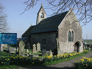
Llangybi is a village and community in Monmouthshire, in southeast Wales, in the United Kingdom. It is located 3 miles (4.8 km) south of the town of Usk and 5 miles (8 km) north of Caerleon, in the valley of the River Usk.

<span class="mw-page-title-main">Mathern</span> Human settlement in Wales

Mathern is a village, community, and historic parish in Monmouthshire, south east Wales, about 3 miles (4.8 km) south west of the town of Chepstow, close to the Severn Estuary, the Bristol Channel and the M48 motorway. The village is designated as a Conservation Area. It is now bisected by the motorway, which passes over the road through the village, with the original village located to the south and Newton Green to the north.

<span class="mw-page-title-main">Llangwm, Monmouthshire</span> Human settlement in Wales

Llangwm is a small rural village and former community, now in the community of Llantrisant Fawr, in Monmouthshire, south east Wales. It is located 3 miles (4.8 km) east of Usk, on the B4235 Chepstow to Usk road. The main village is at Llangwm Uchaf, with a smaller and more dispersed settlement about 1 mile (1.6 km) to the north-east at Llangwm Isaf .The other settlement in the community is Llansoy. In 2022 the community was abolished and merged with Llantrisant Fawr.

<span class="mw-page-title-main">Llantrisant, Monmouthshire</span>

Llantrisant is a village in Monmouthshire, south east Wales, United Kingdom. The community population at the 2011 census was 475.

<span class="mw-page-title-main">Newcastle, Monmouthshire</span> Human settlement in Wales

Newcastle is a small village in Monmouthshire, south east Wales, United Kingdom. It is located in quiet rolling countryside 6 miles (9.7 km) north west of Monmouth and 9 miles (14 km) east of Abergavenny, on the B4347 road, within the community of Whitecastle.

<span class="mw-page-title-main">Penhow Castle</span> Castle in Penhow, Newport

Penhow Castle, Penhow, Newport dates from the early 12th century. Extended and reconstructed in almost every century since, it has been claimed to be the oldest continuously-inhabited castle in Wales. The castle is a Grade II* listed building.

<span class="mw-page-title-main">Llandevaud</span> Hamlet in Newport, Wales

Llandevaud is a hamlet in Newport, Wales. It is situated between the A48 Newport-Chepstow Road and the M4 motorway, 1 mile (1.6 km) east of the village of Langstone. It is part of the community of Langstone.

<span class="mw-page-title-main">Parc-Seymour</span> Hamlet in Newport, Wales

Parc-Seymour, is a hamlet in Newport, Wales. It is north of the A48 Newport-Chepstow road, 10 kilometres east-northeast of Newport, within the ancient parish of Penhow, the hamlet of which lies east-southeast of Parc-Seymour.

<span class="mw-page-title-main">Fred Hando</span> Welsh writer, artist, teacher, and historian

Frederick James Hando MBE was a Welsh writer, artist and schoolteacher from Newport. He chronicled the history, character and folklore of Monmouthshire, which he also called Gwent, in a series of nearly 800 newspaper articles and several books published between the 1920s and 1960s.

<span class="mw-page-title-main">White Hart Inn, Llangybi</span> House in Llangybi, Monmouthshire

The White Hart Inn, Llangybi, Monmouthshire is a public house dating from the early 17th century. Located at a crossroads in the centre of the village, it is a Grade II* listed building.

References

  1. Office for National Statistics Parish Headcounts: Penhow
  2. Owen, Hywel Wyn; Morgan, Richard (2007). Dictionary of the Place-names of Wales. Llandysul: Gomer. p. 366. ISBN   1-84323-901-9.
  3. 1 2 Newman, John (2000), The Buildings of Wales: Gwent/Monmouthshire, ISBN   0-14-071053-1
  4. "ARCHI Maps of British Archaeological Sites Location Data in Gwent near Penhow | Metal Detecting Finds | Treasure Hunting Findspots | Family History | Treasure Trove | Ancient History and Archaeology of Gwent Metal Detecting Finds & Treasure Hunting Findspots & Places at British National Grid Reference (NGR) co-ordinates at ST4290, ST 42 90, ST 42 90 | Treasure Map | ARCHI UK| archiUK". www.archiuk.com. Retrieved 20 September 2019.
  5. Wilhelmina, Duchess of Cleveland The Battle Abbey Roll with some Account of the Norman Lineages, 3 volumes, London, 1889, vol.1, Sent More
  6. Newman 2000, p. 552.
  7. "Penhow Castle". www.castlexplorer.co.uk. Castles of England, Scotland & Wales. Archived from the original on 14 April 2015. Retrieved 25 May 2018.
  8. Staff writer (16 April 2003). "Has Penhow Castle got American owners?". www.southwalesargus.co.uk. South Wales Argus.
  9. "Penhow Castle". www.castlewales.com.
  10. Psychic investigation at Penhow Castle
  11. "Castle closes gates to visitors". 31 December 2002 via news.bbc.co.uk.
  12. "Penhow Village Shop – We are here to support you".
  13. "The home of the Sunday Roast". rockandfountaininn.com.
  14. "New all-you-can-eat restaurant to bring taste of South America to Newport". South Wales Argus. 16 February 2018.
  15. "Penhow History Group". Penhow History Group. 16 May 2016.
  16. "New weather record as Wales wilts". 20 July 2006 via news.bbc.co.uk.
  17. "Community council election nominees for Newport revealed". South Wales Argus . 6 April 2022. Retrieved 22 August 2022.