
Caerleon is a town and community in Newport, Wales. Situated on the River Usk, it lies 5 miles (8 km) northeast of Newport city centre, and 5.5 miles (9 km) southeast of Cwmbran. Caerleon is of archaeological importance, being the site of a notable Roman legionary fortress, Isca Augusta, and an Iron Age hillfort. Close to the remains of Isca Augusta are the National Roman Legion Museum and the Roman Baths Museum. The town also has strong historical and literary associations: Geoffrey of Monmouth elevated the significance of Caerleon as a major centre of British history in his Historia Regum Britanniae, and Alfred Lord Tennyson wrote Idylls of the King (1859–1885) while staying in Caerleon.

The River Usk rises on the northern slopes of the Black Mountain, Wales, in the westernmost part of the Brecon Beacons National Park. Initially forming the boundary between Carmarthenshire and Powys, it flows north into Usk Reservoir, then east by Sennybridge to Brecon before turning southeast to flow by Talybont-on-Usk, Crickhowell and Abergavenny after which it takes a more southerly course.

Newport is a city and county borough in Wales, situated on the River Usk close to its confluence with the Severn Estuary, 12 miles northeast of Cardiff. With a population of 145,700 at the 2011 census, Newport is the third-largest authority with city status in Wales, and seventh most populous overall. Newport became a unitary authority in 1996 and forms part of the Cardiff-Newport metropolitan area. Newport was the site of the last large-scale armed insurrection in Great Britain, the Newport Rising of 1839.

The A48 is a trunk road in Great Britain running from the A40 at Highnam, 3 miles (4.8 km) west of Gloucester, England, to the A40 at Carmarthen, Wales. Before the Severn Bridge opened on 8 September 1966, it was a major route between England and South Wales. For most of its route, it runs almost parallel to the M4 motorway. During times of high winds at the Severn Bridge, the A48 is used as part of the diversion route and is still marked as a Holiday Route.

Newport railway station is the second-busiest railway station in Wales, situated in Newport city centre. It is 133.5 miles (215 km) from London Paddington on the British railway network.

There have been many railway stations in Newport, due to its importance as a port for the industrial Monmouthshire and Glamorganshire valleys. The only stations in use at the moment are Newport in the city centre and in the Western valley Pye Corner and Rogerstone.

The Monmouthshire and Brecon Canal is a small network of canals in South Wales. For most of its currently (2018) navigable 35-mile (56 km) length it runs through the Brecon Beacons National Park, and its present rural character and tranquillity belies its original purpose as an industrial corridor for coal and iron, which were brought to the canal by a network of tramways and/or railroads, many of which were built and owned by the canal company.
St Julians is a community and coterminous electoral district (ward) of the City of Newport, South Wales.

Rogerstone is a large village and community (parish) in Newport, Wales. The area is governed by Newport City Council. The village falls within the ancient parish of Bassaleg and historic county of Monmouthshire.
Maesglas or Maes-glas is a neighbourhood in the south west of the city of Newport, South Wales. In the 16th century it was recorded as Greenfield but the Welsh language name Maesglas has remained the more widely used, among English speakers.

Bassaleg is a suburb on the west side of Newport, Wales. It is in the Graig electoral ward and community.
Newport city centre is traditionally regarded as the area of Newport, Wales bounded by the west bank of the River Usk, the George Street Bridge, the eastern flank of Stow Hill and the South Wales Main Line. Most of the city centre is contained within two conservation areas: the central area and the area around Lower Dock Street. Most of the city centre is located in the Stow Hill district.

Crindau is an older inner-city area just north of the city centre in Newport in south-east Wales. It lies within the Shaftesbury electoral district (ward) and community (parish).
Transport in Cardiff, capital and most populous city in Wales involves road, rail, bus, water and air. It is a major city of the United Kingdom and a centre of employment, government, retail, business, culture, media, sport and higher education.
The Monmouthshire Railway and Canal Company was a canal and railway company that operated a canal and a network of railways in the Western Valley and Eastern Valley of Newport, Monmouthshire. It started as the Monmouthshire Canal Navigation and opened canals from Newport to Pontypool and to Crumlin from 1796. Numerous tramroads connected nearby pits and ironworks with the canal.
Riverside is a mixed residential and commercial area close to Newport city centre, South Wales.

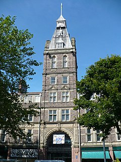
Newport Technical Institute is a Grade II-listed building in the city centre of Newport, Wales.

Ebbw Vale bus station, also known as Inner Bypass, is a bus terminus located in the town centre of Ebbw Vale, South Wales.
 Definitions from Wiktionary
 Media from Commons
 News from Wikinews
 Quotations from Wikiquote
 Texts from Wikisource
 Textbooks from Wikibooks
 Resources from Wikiversity