
Commercial Street is a 700-yard (660-metre) long main shopping street leading from the city centre of Newport, South Wales.
Commercial Street is a 700-yard (660-metre) long main shopping street leading from the city centre of Newport, South Wales.
Commercial Street and Commercial Road were created in 1810 across open pasture land [1] which had to be raised several feet using ship ballast so that it no longer flooded at the high Spring tides. [2] This was part of a plan by Charles Morgan, 1st Baron Tredegar to increase Newport's importance and develop his land; in 1807 he had granted a lease on 200 acres of land to allow the Tredegar Wharf Company to create the new mile-long road. [2] The new road led approximately south-southeast from the junction with High Street (and Westgate Hotel), linking the town centre with Pillgwenlly and the early Newport Docks.
Notable buildings on Commercial Street were the Westgate Hotel [3] (now on what is called Westgate Square), Newport's Town Hall (1885 by T. M. Lockwood, [4] demolished when it was replaced by the 1940 Civic Centre), the Empire Theatre (which burnt down in the 1940s), [5] and several banks and large department stores. [3] [6]
The northern half of Commercial Street, from Westgate Square as far as Hill Street, is part of the Town Centre Conservation Area, including many listed buildings rising to three or four storeys, dating from the Victorian period to the early 20th century. [7]
In the 2010s several large national stores left Commercial Street, amongst them Marks and Spencer, Burton and Monsoon leaving empty shop units, charity shops or bargain stores in their place. [8] [9]
Joining Commercial Street to John Frost Square is Llanarth Street, the shops on which include shoe shop A. G. Meek, trading since 1912 [10] and Vacara's Fish and Chip shop, which opened around 1900. [11]

Usk is a town and community in Monmouthshire, Wales, 10 miles (16 km) northeast of Newport. It is located on the River Usk, which is spanned by an arched stone bridge at the western entrance to the town. Usk Castle, above the town, overlooks the ancient crossing point. It developed as a small market town, with some industry including the making of Japanware, and with a notable prison built in 1841/2. In recent years Usk has become known for its history of success in Britain in Bloom competitions, winning the Large Village award in 2005. The resident population of the town in 2001 was 2,318, increasing to 2,834 at the 2011 census.

Cwmbran is a town in the county borough of Torfaen in South Wales.

Chepstow is a town and community in Monmouthshire, Wales, adjoining the border with Gloucestershire, England. It is located on the tidal River Wye, about 2 miles (3.2 km) above its confluence with the River Severn, and adjoining the western end of the Severn Bridge. It is the easternmost settlement in Wales, situated 16 miles (26 km) east of Newport, 28 miles (45 km) east-northeast of Cardiff, 18 miles (29 km) northwest of Bristol and 110 miles (180 km) west of London.

Newport is a city and county borough in Wales, situated on the River Usk close to its confluence with the Severn Estuary, 12 mi (19 km) northeast of Cardiff. With a population of 145,700 at the 2011 census, Newport is the third-largest authority with city status in Wales, and seventh most populous overall. Newport became a unitary authority in 1996 and forms part of the Cardiff-Newport metropolitan area. Newport was the site of the last large-scale armed insurrection in Great Britain, the Newport Rising of 1839. The population grew considerably during the 2021 census, rising to 159,587, the largest growth of a unitary authority in Wales.

Blaenau Gwent is a county borough in the south-east of Wales. It borders the unitary authority areas of Monmouthshire and Torfaen to the east, Caerphilly to the west and Powys to the north. Its main towns are Abertillery, Brynmawr, Ebbw Vale and Tredegar. Its highest point is Coity Mountain at 1,896 feet (578 m).

Cardiff city centre is the city centre and central business district of Cardiff, Wales. The area is tightly bound by the River Taff to the west, the Civic Centre to the north and railway lines and two railway stations – Central and Queen Street – to the south and east respectively. Cardiff became a city in 1905.

Tredegar is a town and community situated on the banks of the Sirhowy River in the county borough of Blaenau Gwent, in the southeast of Wales. Within the historic boundaries of Monmouthshire, it became an early centre of the Industrial Revolution in Wales. The relevant wards collectively listed the town's population as 15,103 in the UK 2011 census.

The University of Wales, Newport, was a university based in Newport, South Wales, before the merger that formed the University of South Wales in April 2013. The university had two campuses in Newport, Caerleon on the northern outskirts of the city, which was subsequently closed during July 2016, and a £35 million campus on the east bank of the River Usk in Newport city centre which opened in 2011. In 2012 the university was ranked 111th out of 120 UK universities in the Guardian League Table for university rankings, 105th out of 116 in The Complete University Guide and 104th out of 116 UK universities in the Times Good University Guide.

Tredegar House is a 17th-century Charles II-era mansion on the southwestern edge of Newport, Wales. For over five hundred years it was home to the Morgan family, later Lords Tredegar; one of the most powerful and influential families in the area. Described as, "the grandest and most exuberant country house in Monmouthshire" and one of the "outstanding houses of the Restoration period in the whole of Britain", the mansion stands in a reduced landscaped garden of 90 acres (0.36 km2) forming the non-residential part of Tredegar Park. The property became a Grade I listed building on 3 March 1952 and has been under the care of the National Trust since March 2012. The park surrounding the house is designated Grade II* on the Cadw/ICOMOS Register of Parks and Gardens of Special Historic Interest in Wales.

Newport Civic Centre is a municipal building in Godfrey Road in Newport, South Wales. The civic centre, which is the headquarters of Newport City Council, is a Grade II* Listed building.

The Royal Gwent Hospital is a local general hospital in the city of Newport. It is managed by the Aneurin Bevan University Health Board. Since 2020, the hospital no longer has a full Emergency Department, and redirects those with a serious illness or injury to call 999 or go to attend the Grange University Hospital in Cwmbran. The Royal Gwent hospital has a 24-hour Minor Injuries Unit.

Newport city centre is traditionally regarded as the area of Newport, Wales bounded by the west bank of the River Usk, the George Street Bridge, the eastern flank of Stow Hill and the South Wales Main Line. Most of the city centre is contained within two conservation areas: the central area and the area around Lower Dock Street. Most of the city centre is located in the Stow Hill district.

The South Wales Argus is a daily tabloid newspaper published in Newport, South Wales. The Argus is distributed in Newport, Blaenau Gwent, Caerphilly, Monmouthshire, and Torfaen.

Frederick James Hando MBE was a Welsh writer, artist and schoolteacher from Newport. He chronicled the history, character and folklore of Monmouthshire, which he also called Gwent, in a series of nearly 800 newspaper articles and several books published between the 1920s and 1960s.

Habershon & Fawckner or Habershon, Pite & Fawckner was a British architectural practice active in England and Wales from the 1860s, particularly in Cardiff and the South Wales area. They had had offices in London, Cardiff and Newport, designing a large number of houses, villas and non-conformist chapels.
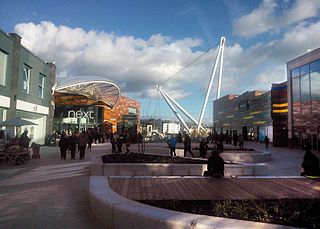
John Frost Square is a large public space in the centre of Newport, South Wales, named after the Chartist leader, John Frost. It was redeveloped as part of the Friars Walk shopping and leisure complex in 2014 and 2015.

High Street is the main historical street and the original main thoroughfare in the centre of Newport, South Wales. Nowadays it runs approximately 280m between Westgate Square and the Old Green Interchange.

1–6 Priory Street in Monmouth, Wales, is a row of six shop houses designed by the architect George Vaughan Maddox and constructed c. 1837. They form part of Maddox's redevelopment of the centre of Monmouth and stand opposite his Market Hall. The architectural historian John Newman has written that Maddox's work "gives Monmouth its particular architectural flavour," and considers Priory Street to be "his greatest work."
The 1973 Gwent County Council election was held on Thursday 12 April 1973 to elect councillors to the new Gwent County Council, governing the new county of Gwent, Wales. It took place on the same day as other county council elections in the United Kingdom.