The London Borough of Croydon is a London borough in south London, part of Outer London. It covers an area of 87 km2 (33.6 sq mi). It is the southernmost borough of London. At its centre is the historic town of Croydon from which the borough takes its name; while other urban centres include Coulsdon, Purley, South Norwood, Norbury, New Addington, Selsdon and Thornton Heath. Croydon is mentioned in Domesday Book, and from a small market town has expanded into one of the most populous areas on the fringe of London. The borough is now one of London's leading business, financial and cultural centres, and its influence in entertainment and the arts contribute to its status as a major metropolitan centre. Its population is 390,719, making it the most populous London borough and sixteenth largest English district.

Addington is a village and area in south London, England, within the London Borough of Croydon. It is south of Spring Park, west of Coney Hall, north of New Addington and east of Forestdale and Selsdon, and is 11.1 miles (18 km) south of Charing Cross and 4 miles (6.4 km) south-east of the centre of Croydon.

Selsdon is an area in South London, England, located in the London Borough of Croydon, in the ceremonial county of Greater London. Prior to 1965 it was in the historic county of Surrey. It now has the character of a suburb and sits at a high elevation, bordering downland.

Croydon is a large town in South London, England, 9.3 miles (15.0 km) south of Charing Cross. Part of the London Borough of Croydon, a local government district of Greater London, it is one of the largest commercial districts in Greater London, with an extensive shopping district. The entire town had a population of 192,064 as of 2011, whilst the wider borough had a population of 384,837.

East Croydon is a railway station, tram stop and associated bus station in Croydon, Greater London, England. It is located in Travelcard Zone 5. At 10 miles 28 chains from London Bridge, it is the 20th busiest station in Britain, was the 10th busiest in 2020–21, is the busiest national rail station in London outside of fare zones 1 and 2 and is one of the busiest non-terminal stations in the country. It is one of three railway stations in the London Borough of Croydon with Croydon in their name, the others being West Croydon and South Croydon. A Tramlink tram stop is located immediately outside the main station entrance.
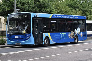
Brighton & Hove Bus and Coach Company Limited, trading as Metrobus, is a bus operator with routes in parts of Surrey, Kent, Sussex, and Greater London. Formed through a management buyout in 1983, Metrobus was purchased by the Go-Ahead Group in September 1999 and is now under the control of Brighton & Hove, part of the Go-Ahead Group.

West Wickham is an area of South East London, England, in the London Borough of Bromley. It lies south of Park Langley, Eden Park Beckenham and Bromley town center, west of Hayes and north of Coney Hall, east of Spring Park and Shirley. 10.3 miles (16.6 km) south-east of Charing Cross on the line of a Roman road, the London to Lewes Way. Before the creation of Greater London in 1965, West Wickham was in Kent.

Shirley is an area of south London, England, within the London Borough of Croydon. It lies north of Spring Park and Addington, east of Addiscombe, south of Monks Orchard and west of West Wickham, and 10 miles south-southeast of Charing Cross. Prior to the creation of Greater London in 1965, Shirley was in the administrative county of Surrey.

Monks Orchard is a suburb on the edge of the London Borough of Croydon, in the ceremonial county of Greater London, England, prior to 1965 it was located in the historical county of Surrey. It is situated about 10 miles (16.1 km) south south-east of Charing Cross, south of Elmers End and Eden Park, west of West Wickham, and north and east of Shirley and Shirley Oaks.

Sanderstead railway station is on the Oxted Line in the London Borough of Croydon, 1 mile (1.6 km) from Sanderstead village. It is in Travelcard Zone 6, 12 miles 23 chains from London Bridge. The station is managed by Southern.
New Addington is an area of South London, England, within the London Borough of Croydon. It is located 5 miles south east of Croydon and is adjacent to the Greater London boundary with Surrey.

South Croydon in south London is the area surrounding the valley south of central Croydon and running as far south as the former Red Deer public house on the Brighton Road. It is bounded by Waddon to the West and Selsdon and Sanderstead to the East. It is part of the South Croydon (CR2) post town and in the London Borough of Croydon.

The Woodside and South Croydon Joint Railway (W&SC) was a short, relatively short-lived and unsuccessful railway in the London Borough of Croydon in London, England. Its site is now largely occupied by Tramlink.

Eden Park is a suburban area in Greater London, England, within the London Borough of Bromley, Greater London and prior to 1965, in the historic county of Kent. It lies south of Beckenham, west of Park Langley and Shortlands, north of West Wickham and Monks Orchard and east of Elmers End.
Coney Hall is an area of Greater London, within the London Borough of Bromley, Greater London and formerly in the historic county of Kent. It is located south of Hayes, west of Keston, north of Nash, and east of West Wickham of which it is usually considered a part. The Prime Meridian passes through Coney Hall.

Woodside tram stop is a light rail stop situated between Woodside Green and Ashburton Park in the London Borough of Croydon in the southern suburbs of London. The stop is located on the site of the former Woodside railway station of the Woodside and South Croydon Railway; the old station buildings survive, though not used by Tramlink.

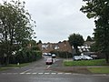
The A2022 is a non-primary road in England. It runs south-west into the foothills of the North Downs from West Wickham in the London Borough of Bromley through Selsdon, Sanderstead, Addington, Purley, the Woodcote part of that town, Banstead in Surrey and Epsom Downs through which it descends to a similar altitude as at its beginning to end at Epsom.

Selsdon Wood is a woodland area located in the London Borough of Croydon. The park is owned by the National Trust but managed by the London Borough of Croydon. It is a Local Nature Reserve. The wood has a Friends group – the Friends of Selsdon Wood (FSW) – who have their own website.

London Buses route 433 is a Transport for London contracted bus route in London, England. Running between Addington Village Interchange and Croydon, it is operated by Transport UK London Bus.