
The Bakerloo line is a London Underground line that runs from Harrow & Wealdstone in suburban north-west London to Elephant & Castle in south London, via the West End. Printed in brown on the Tube map, it serves 25 stations, 15 of which are underground, over 23.2 kilometres (14.4 mi). It runs partly on the surface and partly through deep-level tube tunnels.

The Jubilee line is a London Underground line that runs between Stanmore in suburban north-west London and Stratford in east London, via the Docklands, South Bank and West End. Opened in 1979, it is the newest line on the Underground network, although some sections of track date back to 1932 and some stations to 1879.

The Piccadilly line is a deep-level London Underground line running from the north to the west of London. It has two branches, which split at Acton Town, and serves 53 stations. The line serves Heathrow Airport, and some of its stations are near tourist attractions such as Piccadilly Circus and Buckingham Palace. The District and Metropolitan lines share some sections of track with the Piccadilly line. Printed in dark blue on the Tube map, it is the sixth-busiest line on the Underground network, with nearly 218 million passenger journeys in 2019.

Keston is a village in Greater London, England, located within the London Borough of Bromley, Greater London. Prior to 1965 it was within the historic county of Kent. It is part suburban, part rural in nature and lies on the edge of Hayes Common, just beyond the London conurbation to the south of Bromley Common. It includes the small hamlet of Nash to the southwest. The northern, more suburban part of Keston is sometimes referred to as Keston Mark.

The London Borough of Bexley is a London borough in south-east London, forming part of Outer London. It has a population of 248,287. The main settlements are Sidcup, Erith, Bexleyheath, Crayford, Welling and Old Bexley. The London Borough of Bexley is within the Thames Gateway, an area designated as a national priority for urban regeneration. The local authority is Bexley London Borough Council.
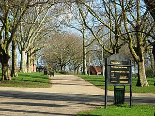
Finsbury Park is a public park in the London neighbourhood of Haringey, north London, England. The park lies on the southern-most edge of the London Borough of Haringey. It is in the area formerly covered by the historic parish of Hornsey, succeeded by the Municipal Borough of Hornsey. It was one of the first of the great London parks laid out in the Victorian era. The park borders the neighbourhoods of Harringay, Finsbury Park, Stroud Green, and Manor House.

Victoria Park is a park in the London Borough of Tower Hamlets in East London, England.

Upton Park is an area of the East London borough of Newham, centred on Green Street which is the boundary between West Ham and East Ham. West Ham United Football Club formerly played at the Boleyn Ground, commonly known as Upton Park.

Welling railway station is situated in Welling, part of the London Borough of Bexley, and is served by the Bexleyheath Line, 11 miles 28 chains (18.3 km) from London Charing Cross.
Danson Park is a public park in the London Borough of Bexley, South East London, located between Welling and Bexleyheath. At 75 hectares, it is the second largest public park in the borough, and the most used by the community. Opened in 1925, it is often considered the finest green open space in the borough, and is Grade II listed on the Register of Historic Parks and Gardens. The park also gives its name to the electoral ward that covers the park and the surrounding area. The park is located at grid reference TQ472752. The southern boundary of both the park and the ward is delineated by Rochester Way, the A2 road.

Dollis Brook runs through the London Borough of Barnet in north London. It is a tributary of the River Brent, which is itself a tributary of the River Thames. The Dollis Valley Greenwalk follows almost all of Dollis Brook, apart from a short section at the beginning which passes through private land, and the London Loop follows it as far as Barnet Lane. The name Dollis is probably derived from the Middle English word 'dole', meaning the shares of land in the common field.
Green Lanes is a main road in North London which forms part of the A105 road. Covering a distance of 6.3 miles (10.1 km) between Newington Green and Winchmore Hill, it is one of the longest streets in the capital, passing through the N16, N4, N8, N13 and N21 postcode areas.
The London Borough of Bexley owns and maintains over 100 parks and open spaces within its boundaries, with a total of 638 hectares. They include small gardens, river and woodland areas, and large parks with many sporting and other facilities.

Ravenscourt Park or RCP is an 8.3 hectares public park and garden located in the London Borough of Hammersmith and Fulham, England. It is one of the Borough's flagship parks, having won a Green Flag Award. Stamford Brook and Ravenscourt Park tube stations are close by.

Southwark Park is located in Rotherhithe, in central South East London, England, and is managed by the London Borough of Southwark. It first opened in 1869 by the Metropolitan Board of Works as one of its first parks. It was designed by Alexander McKenzie and covers 63 acres (250,000 m2). It takes its name from being in what was the old Parliamentary constituency of Southwark at the time of its opening.

Moat Mount Open Space is a 110-hectare park and nature reserve in Mill Hill in the London Borough of Barnet. It is part of Moat Mount Open Space and Mote End Farm Site of Borough Importance for Nature Conservation, Grade II, which includes Barnet Gate Wood and Scratchwood Countryside Park, but is separate from Scratchwood itself, which is a neighbouring park and nature reserve. Most of the site is open to the public, but Mote End Farm and some other areas are private. Scratchwood and Moat Mount are a Local Nature Reserve.

The Dollis Valley Greenwalk is a footpath route in the London Borough of Barnet in London, England, between Moat Mount Nature Reserve in Mill Hill and Hampstead Heath. The route is designed to act as a link between the Capital Ring and the London Loop, and between the many green spaces and wildlife corridors along the way. It is approximately 10 miles (16 km) long. It mainly follows the Dollis Brook and is one of the many parks and open spaces in Barnet.

Mutton Brook is a stream which runs between East Finchley and Hendon in the London Borough of Barnet. It is a tributary of the River Brent, which is itself a tributary of the River Thames.

Parsloes Park is a 58 hectare public park in Dagenham in the London Borough of Barking and Dagenham. It is owned and managed by the borough council. A small area opposite the Wren Road entrance is managed for wildlife and designated as a Local Nature Reserve called Parsloes Park Squatts.

Lonsdale Road Reservoir is a disused reservoir in Barnes in the London Borough of Richmond upon Thames. It is an 8.2 hectare local nature reserve and Site of Borough Importance for Nature Conservation, Grade 1, owned and managed by Richmond upon Thames London Borough Council.


