
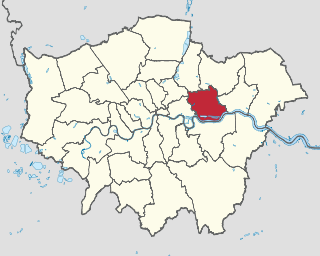
The London Borough of Croydon is a London borough in south London, part of Outer London. It covers an area of 87 km2 (33.6 sq mi). It is the southernmost borough of London. At its centre is the historic town of Croydon from which the borough takes its name; while other urban centres include Coulsdon, Purley, South Norwood, Norbury, New Addington and Thornton Heath. Croydon is mentioned in Domesday Book, and from a small market town has expanded into one of the most populous areas on the fringe of London. The borough is now one of London's leading business, financial and cultural centres, and its influence in entertainment and the arts contribute to its status as a major metropolitan centre. Its population is 390,719, making it the Largest London borough and sixteenth largest English district.

The London Borough of Islington is a London borough which forms part of Inner London. Islington has an estimated population of 215,667. It was formed in 1965 under the London Government Act 1963, which simultaneously abolished the metropolitan boroughs of Islington and Finsbury.

The London Borough of Hackney is a London borough in Inner London. The historical and administrative heart of Hackney is Mare Street, which lies 5 miles (8 km) north-east of Charing Cross. The borough is named after Hackney, its principal district. Southern and eastern parts of the borough are popularly regarded as being part of east London, with the northwest belonging to north London. Its population is 281,120 inhabitants.

The London Borough of Hounslow is a London borough in West London, England, forming part of Outer London. It was created in 1965 when three smaller borough councils amalgamated under the London Government Act 1963. It is governed by Hounslow London Borough Council.
Feltham is a town in West London, England, 13 miles (21 km) from Charing Cross. Historically part of Middlesex, it became part of the London Borough of Hounslow in 1965. The parliamentary constituency of Feltham and Heston has been held by Labour Party MPs since 1992. In 2011, the population of the combined census area of Feltham, Bedfont and Hanworth was 63,368.

The London Borough of Waltham Forest is a London borough in north-east London, England. Its population is estimated to be 276,983 in 2019. It borders five other London boroughs: Enfield to the north-west, Haringey to the west, Hackney to the south-west, Newham to the south-east and Redbridge to the east, as well as the non-metropolitan county of Essex to the north.
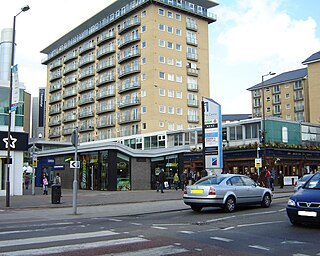
The London Borough of Newham is a London borough created in 1965 by the London Government Act 1963. It covers an area previously administered by the Essex county boroughs of West Ham and East Ham, authorities that were both abolished by the same act. The name Newham reflects its creation and combines the compass points of the old borough names. Situated in the East London part of Inner London, Newham has a population of 387,576, which is the third highest of the London boroughs and also makes it the 17th most populous district in England. The local authority is Newham London Borough Council.

Air Raid Precautions (ARP) refers to a number of organisations and guidelines in the United Kingdom dedicated to the protection of civilians from the danger of air raids. Government consideration for air raid precautions increased in the 1920s and 30s, with the Raid Wardens' Service set up in 1937 to report on bombing incidents. Every local council was responsible for organising ARP wardens, messengers, ambulance drivers, rescue parties, and liaison with police and fire brigades.

The Borough of Dartford is a local government district in the north-west of the county of Kent, England. Its council is based in the town of Dartford. It is part of the contiguous London urban area. It borders the borough of Gravesham to the east, Sevenoaks District to the south, the London Borough of Bexley to the west, and the Thurrock unitary authority in Essex to the north, across the River Thames. The borough was formed on 1 April 1974 by the merger of the Municipal Borough of Dartford, the Swanscombe Urban District, and part of the Dartford Rural District. According to the 2011 Census, its population was 97,365.
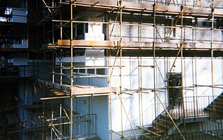
Pear Tree House was the former Civil Defence control centre for South-East London. It is a block of council flats in the Central Hill Estate of Upper Norwood with eight two-bedroom flats and the control centre in the basement.

The Metropolitan Borough of Greenwich was a metropolitan borough in the County of London between 1900 and 1965. It bordered the boroughs of Woolwich, Lewisham and Deptford and, across the River Thames, the borough of Poplar and the County Borough of West Ham in Essex. Within the area of the borough were the Royal Naval College, the Royal Observatory and Greenwich Park.

The Metropolitan Borough of Stoke Newington was a metropolitan borough in the County of London between 1900 and 1965 when it became part of the London Borough of Hackney.

Broxtowe is a local government district with borough status in Nottinghamshire, England, west of the City of Nottingham. The population of the district as taken at the 2011 Census was 109,487. It is part of the Nottingham Urban Area. Broxtowe's neighbour to the west is the borough of Erewash, which is in Derbyshire.

The Borough of Basildon is a local government district in south Essex in the East of England, centred on the town of Basildon. It was formed as the Basildon District on 1 April 1974 from the former area of Basildon Urban District and the part of Thurrock Urban District that was within the Basildon New Town. The population of the district as of 2010 is about 172,000. The local authority is Basildon Borough Council. The council made an application for borough status in February 2010 and this was given approval that year, with Mo Larkin becoming the first mayor in October.

The Local Government Act 1985 is an Act of Parliament in the United Kingdom. Its main effect was to abolish the six county councils of the metropolitan counties that had been set up in 1974, 11 years earlier, by the Local Government Act 1972, along with the Greater London Council that had been established in 1965. In their place many single purpose authorities known collectively as 'joint authorities' were established for fire service, police and passenger transport. An ad hoc education authority was established for Inner London and a planning authority for Greater London. The legislation permitted councils to form 'joint arrangements' for waste disposal and other services that they wished to provide together. Time-limited residuary bodies were created to dispose of the assets of the former authorities.
New Eltham is an area of south east London, in the London Boroughs of Greenwich and Bexley. It lies south east of Eltham and north west of Sidcup.

West Ham was a local government district in the extreme south west of Essex from 1886 to 1965, forming part of the built-up area of London, although outside the County of London. It was immediately north of the River Thames and east of the River Lea.
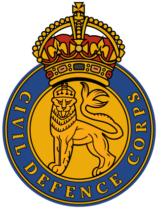
The Civil Defence Corps (CDC) was a civilian volunteer organisation established in Great Britain in 1949 to mobilise and take local control of the affected area in the aftermath of a major national emergency, principally envisaged as being a Cold War nuclear attack. By March 1956, the Civil Defence Corps had 330,000 personnel. It was stood down in Great Britain in 1968, although two Civil Defence Corps still operate within the British Isles, namely the Isle of Man Civil Defence Corps and the unrelated Civil Defence Ireland in the Republic of Ireland. Many other countries maintain a national Civil Defence Corps, usually having a wide brief for assisting in large scale civil emergencies such as flood, earthquake, invasion, or civil disorder.
The Lines of Communication were English Civil War fortifications commissioned by Parliament and built around London between 1642 and 1643 to protect the capital from attack by the Royalist armies of Charles I. It acted to supplement the inner defences provided by Roman and medieval wall in the City of London which underwent repairs and maintenance at this time.
The London Borough of Camden is a London borough in Inner London. Camden Town Hall, on Euston Road, lies 1.4 mi (2.3 km) north of Charing Cross. The borough was established on 1 April 1965 from the area of the former boroughs of Hampstead, Holborn, and St Pancras—which together, prior to that date, had comprised part of the historic County of London.
