
Barnes is a district in south London, part of the London Borough of Richmond upon Thames, England. It takes up the extreme north-east of the borough, and as such is the closest part of the borough to central London. It is centred 5.8 miles (9.3 km) west south-west of Charing Cross in a bend of the River Thames.
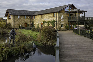
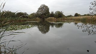
WWT London Wetland Centre is a wetland reserve managed by the Wildfowl and Wetlands Trust in the Barnes area of the London Borough of Richmond upon Thames, southwest London, England, by Barn Elms. The site is formed of four disused Victorian reservoirs tucked into a loop in the Thames.

East Sheen, also known as Sheen, is a suburb in south-west London in the London Borough of Richmond upon Thames.

Spelthorne is a local government district and borough in Surrey, England. Its council is based in Staines-upon-Thames; other settlements in the area include Ashford, Sunbury-on-Thames, Shepperton, Stanwell and Laleham.
Wimbledon Common is a large open space in Wimbledon, southwest London. There are three named areas: Wimbledon Common, Putney Heath, and Putney Lower Common, which together are managed under the name Wimbledon and Putney Commons totalling 460 hectares. Putney Lower Common is set apart from the rest of the Common by a minimum of 1 mile of the built-up western end of Putney.

Kingston Vale with Kingston Hill is a district in the Royal Borough of Kingston upon Thames in south-west London. It is a residential area between Richmond Park, the much smaller Putney Vale, Wimbledon Common, Coombe/Coombe Hill and the Norbiton part of the very old borough. The main road is the A308 which is a through route for traffic passing to and from Kingston Hill to the A3 trunk road. Many of the branch roads are cul-de-sacs. It includes, toward the east and in the Vale, the only part of Kingston which drains eastward, that is, into Beverley Brook. The hill expanse, shared with Coombe and a golf course, has a hotel, some tall blocks overlooking Kingston, the edge of Kingston Hospital, the main campus of Kingston University London and faint remnants of dense woodland.
Whitton is an area of the London Borough of Richmond upon Thames, England. Historically, it was the north-western part of Twickenham manor, bounded by the River Crane and the Duke of Northumberland's River.

Beverley Brook is a 14.3 km (8.9 mi)-long river in the south-western suburbs of London, England. It rises in Worcester Park and joins the River Thames to the north of the Putney Embankment at Barn Elms, having flowed through the green spaces of Wimbledon Common, Richmond Park, Barnes Common and Putney Lower Common on its course. It is followed for much of its course by the Beverley Brook Walk.
Putney Lower Common is an open parkland space in the London Borough of Wandsworth between the town centres of Putney and Barnes. It is part of Wimbledon and Putney Commons, lying 1.5 miles from the rest of the common area.

Richmond Park is a constituency in Greater London represented in the House of Commons of the UK Parliament. Since 2019, its Member of Parliament (MP) has been Sarah Olney of the Liberal Democrats.

The London Government Act 1899 was an Act of the Parliament of the United Kingdom that reformed the administration of the capital. The Act divided the County of London into 28 metropolitan boroughs, replacing the 41 parish vestries and District Boards of Works administering the area. The legislation also transferred a few powers from the London County Council to the boroughs, and removed a number of boundary anomalies. The first elections to the new boroughs were held on 1 November 1900.

Brixton Hundred or the Hundred of Brixton was for many centuries a group of parishes (hundred) used for meetings and taxation of their respective great estates in the north east of the county of Surrey, England. Its area has been entirely absorbed by the growth of London; with its name currently referring to the Brixton district. Its area corresponds to London Boroughs: Southwark, Lambeth, Wandsworth and parts of Lewisham, Merton and Richmond upon Thames.

Moat Mount Open Space is a 110-hectare park and nature reserve in Mill Hill in the London Borough of Barnet. It is part of Moat Mount Open Space and Mote End Farm Site of Borough Importance for Nature Conservation, Grade II, which includes Barnet Gate Wood and Scratchwood Countryside Park, but is separate from Scratchwood itself, which is a neighbouring park and nature reserve. Most of the site is open to the public, but Mote End Farm and some other areas are private. Scratchwood and Moat Mount are a Local Nature Reserve.
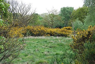
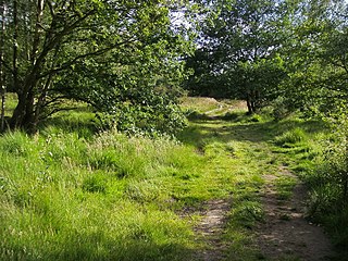
Barnes Common is a local nature reserve on common land in the south east of Barnes, London, England, adjoining Putney Lower Common to the east and bounded to the south by the Upper Richmond Road. Along with Barnes Green, it is one of the largest zones of common land in London with 49.55 hectares of protected commons. It is also a Local Nature Reserve. Facilities include a full-size football pitch and a nature trail.
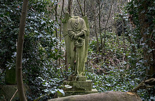
Barnes Cemetery, also known as Barnes Old Cemetery, is a disused cemetery in Barnes, in the London Borough of Richmond upon Thames. It is located off Rocks Lane on Barnes Common.

Ham Lands is a 72-hectare Local Nature Reserve and Site of Metropolitan Importance for Nature Conservation in Ham in the London Borough of Richmond upon Thames and the Royal Borough of Kingston upon Thames. The area is very popular with walkers, nature lovers, and horse-riders. There is an unofficial off-road BMX track near Teddington Lock.
The Chase is a nature reserve in Dagenham in London. Most of it is in the London Borough of Barking and Dagenham, with a small part in Havering. It is owned by the boroughs, and managed by London Borough of Barking & Dagenham - Parks & Countryside Ranger Service. The boroughs have designated the sections in their respective boroughs as Local Nature Reserves. The Chase, together with the neighbouring Eastbrookend Country Park, is also designated a Site of Metropolitan Importance for Nature Conservation.

Oak Avenue is a 1.85 hectare Local Nature Reserve and Grade II Site of Borough Importance for Nature Conservation in Hampton in the London Borough of Richmond upon Thames. It is owned and managed by Richmond upon Thames Borough Council.

The Beverley Brook Walk is a walking route in the south-western suburbs of London, England. It is 11.5 km (7.1 mi) long, of which the last 10.5 kilometres (6.5 mi) follows the lower reaches of the Beverley Brook, a tributary of the River Thames. It starts at New Malden railway station and ends to the north of the Putney Embankment at Barn Elms, having passed through the green spaces of Wimbledon Common, Richmond Park, Barnes Common and Putney Lower Common on its route.


