Addington is a village and area in south London, England, within the London Borough of Croydon. It is south of Spring Park, west of Coney Hall, north of New Addington and east of Forestdale and Selsdon, and is 11.1 miles (18 km) south of Charing Cross and 4 miles (6.4 km) south-east of the centre of Croydon.
Beckenham is a town in Greater London, England, within the London Borough of Bromley and the historic county of Kent. It is located 8.4 miles (13.5 km) south-east of Charing Cross, situated north of Elmers End and Eden Park, east of Penge, south of Lower Sydenham and Bellingham, and west of Bromley and Shortlands. Its population at the 2011 census counted 46,844 inhabitants.

Carshalton is a town, with a historic village centre, in south London, England, within the London Borough of Sutton. It is situated 9.5 miles (15.3 km) south-southwest of Charing Cross, in the valley of the River Wandle, one of the sources of which is Carshalton Ponds in the middle of the village. Prior to the creation of Greater London in 1965, Carshalton was in the administrative county of Surrey.

Mitcham is an area within the London Borough of Merton in South London, England. It is centred 7.2 miles (11.6 km) southwest of Charing Cross. Originally a village in the county of Surrey, today it is mainly a residential suburb, but includes Mitcham Common.

The London Borough of Bromley is the southeasternmost of the 32 London boroughs that make up Greater London, bordering the ceremonial county of Kent, which most of Bromley was part of before 1965. The borough's population is an estimated 332,336. It is named after Bromley, its principal town; other major towns are Penge, Hayes, West Wickham, Chislehurst, Beckenham and Orpington. The local authority is Bromley London Borough Council.

South Norwood Country Park is a park in South Norwood, close to Elmers End and Birkbeck train stations. The historic Kent-Surrey border runs through the site, and since 1965 it has been located wholly in the London Borough of Croydon. It is a 47 hectare green space which opened in 1989. The park is a mix of countryside and parkland, and land formerly used for sewage farms serving the growing London population.

Monks Orchard is a suburb on the edge of the London Borough of Croydon, England, historically located in Surrey. It is situated about 10 miles (16.1 km) south south-east of Charing Cross, south of Elmers End and Eden Park, west of West Wickham, and north and east of Shirley and Shirley Oaks.
The County Borough of Croydon was a local government district in and around the town of Croydon in north east Surrey, England from 1889 to 1965. Since 1965 the district has been part of the London Borough of Croydon within Greater London.

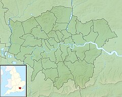
The London Borough of Croydon has over 120 parks and open spaces within its boundaries, ranging from the 200 acre (80ha) Selsdon Wood Nature Reserve to many recreation grounds and sports fields scattered throughout the Borough. Croydon covers an area of 86.52 km², the 256th largest district in England. Croydon's physical features consist of many hills and rivers that are spread out across the borough and into the North Downs, Surrey and the rest of South London. Some of the open spaces in Croydon form part of the well-known London LOOP walks where the first section was opened on 3 May 1996 with a ceremony on Farthing Downs in Coulsdon. As a borough in Outer London it also contains some open countryside in the form of country parks. Croydon Council is associated with several other boroughs who are taking part in the Downlands Countryside Management Project. These boroughs are Sutton; and by Surrey County Council; the City of London Corporation; the Surrey districts of Reigate and Banstead and Tandridge; and the Countryside Agency. An additional partner is Natural Britain.

Woodside is an area in south London, in the London Borough of Croydon and the historic county of Surrey. It is between Addiscombe and South Norwood. It is south of South Norwood, west of Shirley and Monks Orchard, north of Addiscombe, and east of Selhurst.
Beaulieu Heights 16 acres (6.5 ha) is an area of ancient woodland between South Norwood and Upper Norwood in the London Borough of Croydon, London. It is located between South Norwood Hill and Auckland Road with Auckland Rise to the north and Tummonds Gardens to the south. There are pedestrian entrances from South Norwood Hill and Auckland Rise, and a pond. The name is pronounced as if spelled "Beulah" like the nearby Beulah Hill, and not like the French word or the town of Beaulieu, Hampshire.

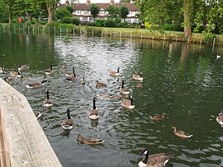
South Norwood Lake and Grounds is a park in South Norwood in the London Borough of Croydon. The main entrance is in Woodvale Avenue while other entrances are located in Auckland Road and Sylvan Road. The area measures up to 281⁄2 acres.

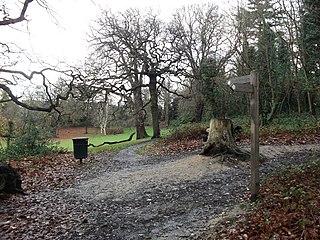
Selsdon Wood is a woodland area located in the London Borough of Croydon. The park is owned by the National Trust but managed by the London Borough of Croydon. It is a Local Nature Reserve. The wood has a Friends group - the Friends of Selsdon Wood (FSW) - who have their own website.

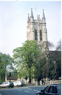
Croydon Minster is the parish and civic church of the London Borough of Croydon. There are currently more than 35 churches in the borough, with Croydon Minster being the most prominent. It is Grade I listed.

Littleheath Woods is the collective name for Littleheath Wood, Foxearth Woods, part of Queenhill Shaw and part of Gee Wood in Selsdon in the London Borough of Croydon. It is a Site of Borough Importance for Nature Conservation, Grade I, with an area of 64 acres (26 ha). It is owned by Croydon Council and the Friends of Littleheath Woods assist with the management.

Spring Park is a small area in London, England. It is within the London Borough of Bromley and the London Borough of Croydon, straddling the traditional Kent-Surrey border along The Beck. Spring Park is located north of Addington, west of West Wickham and south of Monks Orchard and Shirley.

Wandle Park is an 8.5-hectare (21-acre) park located in the Broad Green Ward of Croydon, south London, England. It was opened in 1890 by the Mayor of Croydon. The site is protected by Fields in Trust through a legal "Deed of Dedication" safeguarding the future of the space as public recreation land for future generations to enjoy.

Lloyd Park is a 114 acres (46 ha) park on the outskirts of central Croydon, Greater London, managed by the London Borough of Croydon. It is bordered by Coombe Road to the south and Lloyd Park Avenue to the west. To the north, access is from Deepdene and Mapledale Avenue, and the park adjoins Grimwade Avenue and Addiscombe Cricket Club. To the east the park is bordered by Shirley Park Golf Course. It was created from land owned by Frank Lloyd a newspaper proprietor who died in 1927 which was bequeathed to the Borough of Croydon by his family, after his death.

Spa Wood is an area of ancient woodland in the London Borough of Croydon that was once a part of The Great North Wood. In 2017, the London Wildlife Trust began a four-year project based around the Great North Wood, working with Croydon Council and the Friends of Spa Wood to improve the site for wildlife, as a part of The Great North Wood Project. The 15.5 acres (6.3 ha) site, also known as The Lawns, is owned by the Borough of Croydon and includes the woods, a multi-games court and playground.
Waddon Ponds is an ornamental 8.5 acres (3.4 ha) urban park / inland water in the western part of the London Borough of Croydon, by whom it is managed. It is bordered to the north by Mill Lane, and on the other three sides by Waddon Court Road, Court Drive and The Ridgeway.