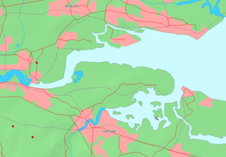
Authorised in 1801, the canal was originally intended to extend northwards to Rotherhithe, but the simultaneous construction of the Grand Surrey Canal provided a convenient access route. It was 9+1⁄4 miles (15km) long, and opened on 22 October 1809.[1]
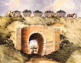
The Croydon Canal linked to the Croydon, Merstham and Godstone Railway (itself connected to the Surrey Iron Railway), enabling the canal to be used to transport stone and lime from workings at Merstham. The canal was never extended further south-west, as was initially intended, to reach Epsom.
The canal was originally planned with two inclined planes but 28 locks, arranged in two flights, were used instead. To keep the canal supplied with water, reservoirs were constructed at Sydenham and South Norwood; the latter still exists as South Norwood Lake in a public park.
History
Origins
A canal from Croydon to Rotherhithe was the idea of Ralph Dodd, who had been commissioned in 1799 to ascertain “… the most eligible part of the River Thames” for a canal from Croydon.[2][3] Dodd’s canal was to be on a small scale, only 3+1⁄2ft (1.1m) deep and 24 feet (7.3m) wide at the top for boats up to 20 tons (20.3 tonnes).[4][3] It would start in today’s Tamworth Road, Croydon and head north to the west of London Road (A23) until Broad Green where it would swing northeast towards Selhurst, Woodside and the west of Beckenham. It would broadly follow the Ravensbourne valley to Lewisham and Deptford, finally turning west of north to join the Thames at Rotherhithe, a distance of about 12 miles.[5][3] Instead of locks there would be horse-powered inclined planes where the boat would be lowered down the hillside in a tank of water or caisson, counterbalanced by another caisson being raised.[6] Bridges would be minimised where possible by using paved fords,[4] the whole costing no more than £25,000.[7][3] After finishing his report in November 1799,[8][3] Dodd had no further involvement with the Croydon and Rotherhithe Canal, but went on to promote a scheme for a Grand Surrey Canal from Rotherhithe.
Design and planning
Following Dodd’s report, a meeting of prospective investors was held at the Croydon Greyhound where it was agreed that a canal from Croydon to Rotherhithe would be of great utility to Croydon, towns close to the canal and considerable parts of Kent, Surrey and Sussex.[9]
A detailed survey was made by Mr Warner, and John Rennie was hired as the consulting engineer.[10] This canal took a more direct line to Rotherhithe along a ridge of higher ground, which could loosely be described as the west side of the Ravensbourne valley. It headed northeast from West Croydon to Selhurst, turned north to South Norwood, Sydenham, Forest Hill and New Cross to join the Thames at Rotherhithe. The canal would remain on the same level from Croydon to Brockley at 149.6ft (45.6m) and drop down the hillside by 17 locks or 2 inclined planes by slightly different paths to New Cross,[11] where it would remain on the same level to a tidal lock at the Thames. Rennie agreed that a canal of small dimensions would be sufficient, but recommended a larger canal to act in part as a reservoir.[12] It was to be 6ft (1.8m) deep, 34ft (10m) wide along the summit level from Croydon and 44ft (13m) wide on the lower Rotherhithe level.[13] Rennie also favoured a canal with steam powered inclined planes over locks on cost grounds.[14] A disadvantage of inclined planes was they could only lift smaller, lighter boats that limited the bulky goods that could be carried on the canal. Several 5-7 ton (5.1 - 7.1 tonnes) boats or barges could be pulled in gangs by a single horse, but there would be delays at the inclined planes where the boats were individually raised or lowered. At over £46,000 Rennie’s canal was nearly twice the cost of Dodd’s; a large proportion of this was for the cost of 47 bridges (£6,460) and steam engines to power the inclined planes (£6,000).[15] The large number of bridges were necessary to allow land owners to access land bisected by the canal.
Royal assent
United Kingdom legislation
Croydon Canal and Croydon, Streatham, Dulwich and Sydenham Water Supply Act 1801
An act for making and maintaining a navigable canal from or from near the town of Croydon, in the county of Surrey, into the Grand Surrey Canal, in the parish of St. Paul, Deptford, in the county of Surrey; and for supplying the towns of Croydon, Streatham and Dulwich, and the district called Norwood, in the parish of Croydon, in the said county of Surrey; and the town of Sydenham, in the county of Kent, with water from the said canal.
Rennie completed his report on the 8 October 1800,[14] which was presented to the investors on 10 October 1800.[16] They adopted Rennie’s recommendation for a canal with inclined planes and submitted a petition to parliament on 18 February 1801.[17] A petition for Dodd’s Grand Surrey Canal had already been submitted,[18] and its proprietors petitioned against the Croydon canal bill in the House of Lords.[19] As a result, the Croydon canal was changed to join the Grand Surrey Canal rather than the Thames.[20] There were other petitions for and against the canal but the biggest effect was the petition from the Wandle mill owners. They were concerned that a deep cut across Croydon Common, between West Croydon and Selhurst would drain water into the canal instead of Norbury Brook and the River Wandle to the detriment of their mills.[21][22] As a result the canal had raised banks across Croydon Common so it only cut 3ft (0.91m) into the soil and reduced its depth to 5ft (1.5m).[23] The summit level between Selhurst and Honor Oak Park was also raised further up the hillside.[24] Despite these delays the canal received royal assent on 27 June 1801 via the Croydon Canal and Croydon, Streatham, Dulwich and Sydenham Water Supply Act 1801 (41 Geo. 3. (U.K.) c. cxxvii).[25]
Inclined planes to locks
The decision to implement a canal with locks was made soon after the act of Parliament was passed, because "it was realised the boats would be too small to meet the needs of the public, particularly the conveyance of large sized timber".[26] The board realised there would be little cost advantage over toll-roads without larger 30-35 ton (30.5 - 35.6 tonnes) boats and traffic on the canal would be less than Rennie’s estimate of 5 boats in each direction.[12] Trade was also threatened by the Surrey Iron Railway, which had received royal assent a month before the Croydon canal. Connection with the Grand Surrey Canal took boats close to the King’s Yard and victualing office at Deptford.[26] These docks supplied the Royal Navy, but supply ships sailing along the coast to Portsmouth were liable to attack from the French and an inland navigation was desirable.[27] In 1802, Rennie was commissioned to consider extending the canal to Portsmouth, but ultimately nothing became of it.[28][29][30]
The adoption of locks required a water source for the canal to replace water lost when ascending / descending through the locks. Rennie’s original plan was to pump water from the Thames, which with the cost of the locks made it nearly £20,000 more expensive than a canal with inclined planes.[31] The proprietors considered a deviation between Brockley and the Grand Surrey Canal so the ascent / descent would be less steep, take the canal closer to the King’s Yard and join the Grand Surrey at its southeast corner.[30][32] This conflicted with plans for a branch of the Grand Surrey Canal to Deptford,[18] and was objected to by their board. Instead, reservoirs were built at South Norwood and Sydenham. According to the resident engineer Dudley Clark[33] the canal “is of itself so considerable, that, with the addition of a large reservoir upon Sydenham, and another upon Norwood Common, it leaves no doubt, of a most ample supply in the driest season."[34] The reservoirs collected rainwater from the adjacent hillsides by ditches or feeder canals.[35][36] Rainwater was also collected by ditches on Plowgarlic / Telegraph Hill above New Cross that fed into small reservoirs or side ponds at the locks.[37]
Implementation
The canal was 34 feet (10m) wide. It had a maximum depth of 5 feet (1.5m). After the initial flights of locks, most of the canal followed the 161 feet (49m) contour.[38]
The first 2¼ miles of the canal was dug approximately between today’s Penge West and Forest Hill railway stations.[39] By 17 April 1804 tenders were invited for cutting the remaining 2 miles of the canal’s north end[40] and contracts for the iron and woodwork on “upwards of 20” locks were received a month later.[41] By October 1805 Sydenham reservoir had been completed, the canal was in water and in use from within a few miles of the town of Croydon to Brockley Green for conveying bricks, timber and other materials for the works.[42][43] The Brockley locks were “well built and exceedingly water tight”.[44] Closer to New Cross the canal was less complete and locks were in every stage of their progress. Around March 1807 a commodious bridge carried the New Cross Road over the canal at New Cross.[45] Contrary to Rennie's original plan there were also locks between New Cross Road and the Grand Surrey Canal.[46]
The proprietors expected to join the Grand Surrey canal by July,[47] having announced to the public that it would be open for navigation from the Thames to the crossroads at (South) Norwood.[48] The canal was at least partially open by 15 August 1807.[49] Hugh McIntosh, a major construction contractor, claimed he played a significant part in the canal’s construction.[50]
Having already spent over £68,000 on the canal, the company required a further £30,000 to complete the works and repay the money borrowed.[51] They petitioned Parliament on 10 February 1808[52] and were granted authority to raise the additional funds via the Croydon Canal Act 1808 (48 Geo. 3. c. xviii) on 14 April 1808.[53] Although the act did not increase the tolls, the minimum tonnage was increased from 4 to 20 tons when passing through a lock. Tenders were placed for bricks, building the basin wall at Croydon, fencing, a crane, counting house, warehouse and lock keeper’s cottage at Forest Wood.[54][55][56][57][58] Despite raising the summit level, it was still lower than Croydon Common and a deviation between Selhurst and West Croydon was considered.[59] Instead it was decided to raise the canal by two additional locks near Selhurst. These final two locks at Croydon Common raised the canal to the 174 feet (53m) contour, and because there was no natural source of water a steam pumping station was built at the foot of the locks to pump water up to the summit pound.[60][61]
At around £300 p.a. this was expensive to run.[62] In June 1830 a new pumping engine was installed on Croydon Common,[63][64] which was the first commercial installation of Samuel Brown's gas vacuum engine, and quite probably the first commercial internal combustion engine in the world. The economics of the gas engine were interesting as the gas it consumed was made by turning coal into coke. The value of the resulting coke and coal tar by-products of making the gas substantially exceeded the cost of the coal, ground rent, repairs etc., so the gas vacuum engine made a profit of over £100 a year before considering the useful work it was doing.[65] Unlike a steam engine, which required time for the water to be heated into steam, Brown’s engine could be turned on and off almost instantly; it was typically used for 3 hours every other day.[66] Around 1827 there was a steam engine near today’s Towpath Way, south of Tennison Road, Selhurst to pump water from a well or spring.[67][68]
The canal had 28 locks, 11 more than Rennie planned (excluding the Thames lock): 10 near New Cross, 16 between Forest Wood (Honor Oak Park) and Brockley, and two near Selhurst.[69] The locks would only admit boats 60ft (18m) long[70] rather than 75ft (23m) long as originally proposed.[71] Lock 26 near Honor Oak Park had three gates which could be used singly or in pairs,[72] and would today be counted as two locks.[38] Near the Thames, the Grand Surrey Canal became a dock which had a lock to protect the canal, and another at the Thames,[73] making a total of 31 locks for the navigation from Croydon to the Thames.
Opening and third act of Parliament
The canal was officially opened on Monday 23 October 1809 with a procession that left Sydenham at 11am to a band playing "God save the King" and a 21 gun salute.[74][75][76][77] The proprietor’s barge was followed by “a great many barges loaded with coal, stone, corn etc.”
At Croydon they were greeted by many thousands of people, church bells, guns firing and a band playing "God save the King". The proprietors witnessed the arrival of the barges at the Croydon basin, examined the wharf and warehouses before walking to the Greyhound at 4pm, led by the workmen marching in order with their tools on their shoulders and accompanied by a band.
An Act for enabling the Company of Proprietors of the Croydon Canal to raise Money to complete the said Canal and Works, and for amending the former Acts passed relative thereto.
Despite the canal being opened, it was not complete. They had not built the road mentioned in clause 10 of their first act between Church Street and the Croydon wharf[78] and in January 1810 they invited tenders for warehouses at Croydon,[79] with more in August.[80] A third act of Parliament, the Croydon Canal Act 1811 (51 Geo. 3. c. xi) was sought and granted in 1811 to raise £80,000 (with £2,658 in hand) to pay off debts (£25,700), loans (£29,615) and complete the works (£27,343).[81][82] The total cost of the canal and works was £150,000.[83] Tenders for the road, and a tramway along its east side were sought.[84][85] The tramway connected with the Croydon Merstham and Godstone railway and ran alongside the south side of the canal basis. It was open for business by January 1812 when it was leased to Edward Grantham.[86] Other work included enlarging the reservoirs and building wharves at New Cross and Sydenham.[87][88][89][90] Sydenham wharf was on the site of today’s Sydenham railway station on Sydenham Road and was initially leased to R Hutson on 22 December 1813.[91] It was subsequently let to Henry Doo on 23 October 1824 until the canal closed when he was a successful coal merchant, lighterman and boat owner with an average trade of £700 p.a. Land owners were also entitled to build wharves (clause 102),[92] which included Penge wharf on the north side of Penge High Street, near Penge West railway station.[75][93]
Boats
By 1811, 22 barges plied the canal. The barges were 60 feet (18m) long and 9 feet (2.7m) wide and could carry about 30 tons. The main cargo was timber.
The barges, or strictly lighters, had flat bottoms, which were joined to the sides of the boat by a quadrant of a circle to reduce damage to the canal bank.[94] Depicted in several paintings,[95][96] the barges had no living accommodation,[97] were steered by a large rudder and pulled by a horse led along the towpath on the easterly side of the canal.[98] At least initially, the docks on the Grand Surrey Canal near the Thames had no towpath.[99] There was also no towpath on the Thames, which barges navigated using the tides, rudder and oar-like sweeps.[100] Navigation through the pool of London was particularly dangerous because of the shipping,[101] and in 1818 a Croydon canal bargeman was assaulted seeking shelter at a private mooring during tempestuous weather.[102]
The boats had to be registered with the canal company and the number, name of the owner and abode had to be painted in white letters 4 inches high on a black background (clause 105).[103] The canal company had its own barges, not only for the construction and maintenance of the canal, but also for its own freight carrier business that barely broke even.[104] This was often prohibited in canal acts to reduce the risk of anticompetitive behaviour.[105][106]
Pleasure craft also plied sections of the canal,[107][108][109] to the benefit of several hostelries.[98][110] The Selhurst lockkeeper, ‘old Grumble’, rented boats at a shilling (5p) an hour.[98]
Trade
Dodd’s introductory report forecast revenues of more than £3,200,[111][112] most of this was from the importation of coal via London:
Dodd's revenue estimates (Based on an average journey of 8 miles and 240d to £1)[113]
Dodd believed the canal would stimulate demand by reducing transportation costs to a quarter to a third of those by road and extend trade to places as far away as East Grinstead.[113] The committee did determine its own forecasts following Rennie’s report,[114] but Phillips feared the lack of manufacturing towns, mines and heavy goods would prevent a proper return for investors.[115]
Trade was boosted with the opening of the canal tramway by around £600 per annum with goods from Merstham quarry transported to the canal via the Croydon Merstham and Godstone iron railway.[116] Toll revenues averaged about £2,700 between 1820 – 1824, but there were additional revenues from rents of about £350 p.a. and £80 p.a. from osier sales, as well as the freight business.[117] This was comparable with Dodd’s estimate, but the capital cost was significantly higher. The tolls authorised by parliament were also higher, although the company may have set lower rates:
Tonnage rates (per ton per mile)
d
Timber, Stone, Coal, Bricks, Tiles, and all other goods and commodities
3
Dung, Chalk etc.
1½
Profits and dividends were significantly less because of costs. In 1827 the canal made a profit of £196 on revenues of £3,634, which had steadily declined from a profit of £500 in 1825.[118] There were calls to close the canal, but it was agreed to continue for another year without incurring further expense.
Closure and opening of the railway
The canal was never a success and closed in 1836,[1] the first canal to be abandoned by an act of Parliament, the London and Croydon Railway Act 1835 (5 & 6 Will. 4. c. x). Much of the alignment was used by the London and Croydon Railway Company, which had bought the canal for £40,250,[1] for part of the railway between London Bridge and West Croydon station, which is on the site of the canal basin. The gas vacuum engine appears to have been in full working order when offered for sale in 1837.[119] It was described as able to lift water a height of 11 feet (3.4m) at a rate of 2,000 imperial gallons per minute (9.1m3/min). Tenders for its purchase (including the 18-foot (5.5m) diameter gasometer) were to be sent to the offices of the Croydon Railway Company, which shared the same address as the London and Croydon Railway Company and dealt with the acquisition of the canal and disposal of any unwanted assets.
Today
After the canal closed, sections were retained for leisure use, and some remained in water for a considerable time. The section at the Anerley Arms, Ridsdale Road in Anerley was used as a boating lake, and the area was called Anerley Tea Rooms. The canal in Betts Park was turned into a concrete trough in 1934, approximately 170m can still be seen at the northern corner of Betts Park. Another section exists as a long curved pond in the Dacres Wood Nature Reserve[120] in Dacres Road, Forest Hill. This was considered for redevelopment in 1989, but research by Lewisham Council resulted in its identity being confirmed and it now forms an attractive wetland, having been returned to its former width.[121][122] There is a high pavement in David's Road, Forest Hill, which is thought to be part of the towpath. Part of the wall below the path has been rebuilt with murals depicting transport in Forest Hill.[123] The Norwood reservoir is now preserved as South Norwood Lake.[124]
Dodd, Ralph (1799). Introductory Report on the proposed canal navigation from Croydon to the River Thames at Rotherhithe. London: Gosnell.
Hadfield, Charles (1969). The Canals of South and South East England. David and Charles. ISBN978-0-7153-4693-8.
Russell, Ronald (1971). Lost canals of England and Wales. David and Charles. ISBN978-0-7153-5417-9.
Salter, Brian J (1986). Retracing canals to Croydon and Camberwell. Living History Publications. ISBN0905592018.
Related Research Articles
The Thames and Medway Canal is a disused canal in Kent, south east England, also known as the Gravesend and Rochester Canal. It was originally some 11 km (6.8 mi) long and cut across the neck of the Hoo peninsula, linking the River Thames at Gravesend with the River Medway at Strood. The canal was first mooted in 1778 as a shortcut for military craft from Deptford and Woolwich Dockyards on the Thames to Chatham Dockyard on the Medway, avoiding the 74 km (46 mi) journey round the peninsula and through the Thames estuary. The canal was also intended to take commercial traffic between the two rivers.
Regent's Canal is a canal across an area just north of central London, England. It provides a link from the Paddington Arm of the Grand Union Canal, 550 yards (500 m) north-west of Paddington Basin in the west, to the Limehouse Basin and the River Thames in east London. The canal is 8.6 miles (13.8 km) long.
William Jessop was an English civil engineer, best known for his work on canals, harbours and early railways in the late 18th and early 19th centuries.
The Surrey Iron Railway (SIR) was a horse-drawn narrow-gauge plateway that linked Wandsworth and Croydon via Mitcham, all then in Surrey but now suburbs of south London, in England. It was established by Act of Parliament in 1801, and opened partly in 1802 and partly in 1803. It was a toll railway on which carriers used horse traction. The chief goods transported were coal, building materials, lime, manure, corn and seeds. The first 8.25 miles (13.28 km) to Croydon opened on 26 July 1803, with a branch line off from Mitcham to Hackbridge.
Croydon is a large town in South London, England, 9.3 miles (15.0 km) south of Charing Cross. Part of the London Borough of Croydon, a local government district of Greater London, it is one of the largest commercial districts in Greater London, with an extensive shopping district. The entire town had a population of 192,064 as of 2011, whilst the wider borough had a population of 384,837.
The Grand Junction Canal is a canal in England from Braunston in Northamptonshire to the River Thames at Brentford, with a number of branches. The mainline was built between 1793 and 1805, to improve the route from the Midlands to London, by-passing the upper reaches of the River Thames near Oxford, thus shortening the journey.
Teddington Lock is a complex of three locks and a weir on the River Thames between Ham and Teddington in the London Borough of Richmond upon Thames, England. Historically in Middlesex, it was first built in 1810.
The London and Croydon Railway (L&CR) was an early railway in England. It opened in 1839 and in February 1846 merged with other railways to form the London, Brighton and South Coast Railway (LB&SCR).
The Diocese of Southwark is one of the 42 dioceses of the Church of England, part of the worldwide Anglican Communion. The diocese forms part of the Province of Canterbury in England. It was created on 1 May 1905 from part of the ancient Diocese of Rochester that was served by a suffragan bishop of Southwark (1891–1905). Before 1877 most of the area was part of the Diocese of Winchester, some being part of the Diocese of London.
The Brighton Main Line is a railway line in southern England linking London to Brighton. It starts at two termini in the capital, London Victoria and London Bridge, and the branches from each meet at East Croydon, from where the route continues southwards via Gatwick Airport to the coast. The line serves the suburbs of South London, as well as the towns of Redhill, Horley, Crawley, Haywards Heath and Burgess Hill.
The Grand Surrey Canal was a canal constructed in south London, England during the early 19th century. It opened to the Old Kent Road in 1807, to Camberwell in 1810, and to Peckham in 1826. Its main purpose was to transport cargo, primarily timber from the Surrey Commercial Docks.
Sydenham is a railway station in Sydenham in the London Borough of Lewisham, South London. Originally opened in 1839, the station is located on the former Croydon Canal, which is now a branch of the Brighton Main Line, often known as the Sydenham Corridor. Sydenham falls within Travelcard Zone 3 and is served by London Overground and Southern. The station is 6 miles 32 chains down the line from London Bridge.
The Aberdeenshire Canal was a waterway in Aberdeenshire, Scotland, designed by John Rennie, which ran from the port of Aberdeen to Port Elphinstone, Inverurie. It was originally planned to reach Monymusk, but had been truncated by the time an act of Parliament was obtained in 1796. Construction was hampered by a lack of finance, and some local opposition, but it opened in 1805. Some of the workmanship was sub-standard, and several of the locks failed soon afterwards, but they were reconstructed, and reopened in late 1806.
The London Borough of Croydon has over 120 parks and open spaces within its boundaries, ranging from the 200 acre (80ha) Selsdon Wood Nature Reserve to many recreation grounds and sports fields scattered throughout the Borough. Croydon covers an area of 86.52 km2, the 256th largest district in England. Croydon's physical features consist of many hills and rivers that are spread out across the borough and into the North Downs, Surrey and the rest of South London. Some of the open spaces in Croydon form part of the well-known London LOOP walks where the first section was opened on 3 May 1996 with a ceremony on Farthing Downs in Coulsdon. As a borough in Outer London it also contains some open countryside in the form of country parks. Croydon Council is associated with several other boroughs who are taking part in the Downlands Countryside Management Project. These boroughs are Sutton; and by Surrey County Council; the City of London Corporation; the Surrey districts of Reigate and Banstead and Tandridge; and the Countryside Agency. An additional partner is Natural Britain.
Josias Jessop (1781–1826) was a canal engineer, and second son of William Jessop, one of the great canal engineers of the late eighteenth and early nineteenth centuries. He was trained by his father, and worked under him on his early projects, but proved his abilities during the construction of Bristol harbour. He became an independent consulting engineer from 1811. He died fourteen years later, a little before he reached the age of 45.
The Norwood Ridge is a 10-square-mile (26 km2) rectangular upland which occupies the geographical centre of south London, centred 5 miles (8 km) south of London Bridge. Beneath its topsoil it is a ridge of London Clay that is capped on all sides with remaining natural gravel deposits mixed with some sandy soil, which in the South Thames basin is a material known as the Claygate Beds.
The London to Portsmouth canal was a concept for the construction of a secure inland canal route from the British capital of London to the headquarters of the Royal Navy at Portsmouth. It would have allowed craft to move between the two without having to venture into the English Channel and possibly encounter enemy ships. There is no naturally navigable route between the two cities, which resulted in several schemes being suggested. The first, which was put before Parliament in 1641, was for a canal to link the River Wey and the River Arun, whose sources were only 2 miles (3.2 km) apart, but the bill was defeated. Improvements to the River Wey were authorised in 1651, and navigation was extended to Godalming in 1763. During the American War of Independence, goods was conveyed to Godalming by water, and overland from there to Portsmouth, but this ceased when the war ended.
The River Wey Navigation and Godalming Navigation together provide a 20-mile (32 km) continuous navigable route from the River Thames near Weybridge via Guildford to Godalming. Both waterways are in Surrey and are owned by the National Trust. The River Wey Navigation connects to the Basingstoke Canal at West Byfleet, and the Godalming Navigation to the Wey and Arun Canal near Shalford. The navigations consist of both man-made canal cuts and adapted parts of the River Wey.
Selhurst is an area in the London Borough of Croydon, England, 7.8 miles (12.6 km) south-south-east of Charing Cross. Historically it lays in Surrey. The area is bounded to the west and south by Thornton Heath and Croydon and to the east and south by South Norwood and Woodside. Selhurst Park, the home stadium of Crystal Palace Football Club, is sited at the northern end of the neighbourhood.
Ralph Dodd was a late 18th-century British civil engineer primarily known for his attempt to produce the first tunnel underneath the Thames in 1798.
↑ Farey, John (1806). "Canal river navigation and rail-ways". In Rees, Abraham (ed.). The Cyclopædia: Universal dictionary of arts, sciences and literature. Vol.6. Philadelphia: Samuel F Bradford. p.109.
↑ "From an American paper". Jackson's Oxford Journal. No.2835. 29 August 1807. p.2.
↑ "Court of compensation". Morning Advertiser. 12 April 1836. p.3.
↑ "To road builders". The Times. 21 May 1811. p.1.
↑ "To iron founders and carpenters". The Times. 7 June 1811. p.1.
↑ "Junction of the Croydon canal". The Times. 29 January 1812. p.5.
↑ House of Lords, Committee office (25 March 1811). "Croydon canal bill". Proceedings at Committees on Private Bills & Other Matters (14/12/1810 - 15/7/1811). 57: 98 – via Parliamentary Archives.
↑ House of Lords (25 March 1811). "Croydon Canal Bill". Proceedings at Committees on Private Bills & Other Matters (14 December 1810 - 15 July 1811). 57: 98 – via Parliamentary archives.
↑ "To excavators". Public Ledger. No.16027. 29 January 1812. p.1.
This page is based on this Wikipedia article Text is available under the CC BY-SA 4.0 license; additional terms may apply. Images, videos and audio are available under their respective licenses.