River Sow Navigation

Last updated

River Sow Navigation
Fairway Bridge River Sow - geograph.org.uk - 2358151.jpg
The river at Fairway Bridge
Specifications
Locks1
Statusabandoned
History
Date of actPrivately built
Date of first use1816
Date closed1920s
Geography
Start point Stafford
End point Baswich
Connects to Staffordshire and Worcestershire Canal
River Sow Navigation
BSicon CONTg.svg
BSicon uexCONTg.svg
River Sow (to source)
BSicon STR.svg
BSicon uexSKRZ-Au.svg
A518 Victoria Road bridge
BSicon BHF.svg
BSicon uexSTR+l.svg
BSicon uexABZgr.svg
Stafford railway station
BSicon STR.svg
BSicon uxWEIRg.svg
BSicon uxMILL.svg
Weir and Town Mill
BSicon STR.svg
BSicon uexSTRl.svg
BSicon uexABZg+r.svg
BSicon STR.svg
BSicon uexSKRZ-Yu.svg
Bridge Street (Green Bridge)
BSicon STR.svg
BSicon ugWHRF.svg
BSicon uxSTRbr.svg
Coal wharf and Royal Brine Baths
BSicon STR.svg
BSicon gSTR.svg
BSicon uexSKRZ-Eu.svg
Towpath bridge
BSicon STR.svg
BSicon gSTRl.svg
BSicon gmABZg+r exu+.svg
BSicon STR.svg
BSicon uexSKRZ-Au.svg
A34 Queensway (built 1970s)
BSicon STR.svg
BSicon uexSKRZ-Yu.svg
Riverway bridge
BSicon CONTgq.svg
BSicon ABZgr.svg
BSicon uexSTR.svg
BSicon STR.svg
BSicon uexSKRZ-Yu.svg
Fairway bridge
BSicon STR+l.svg
BSicon STRr.svg
BSicon uexSTRl.svg
BSicon uexSTR+r.svg
BSicon emKRZo.svg
BSicon uexSTRq.svg
BSicon uexSTR+r.svg
BSicon gSTRq.svg
BSicon gSKRZ-Euq.svg
BSicon gmABZg+r exu+.svg
old course of River Penk
BSicon emKRZo.svg
BSicon uexSTRq.svg
BSicon uexABZg+r.svg
BSicon uexSTR.svg
Deepmoor Drain
BSicon mKRZo.svg
BSicon uSTR+r.svg
BSicon uexSTR.svg
BSicon uexSTR.svg
Staffordshire and Worcestershire Canal
BSicon STR.svg
BSicon ugFABZgl+l.svg
BSicon uxgKRZu.svg
BSicon ugLockl.svg
BSicon uexFABZgr+r.svg
Aqueduct and Baswich Lock
BSicon STR.svg
BSicon uSTR.svg
BSicon uexSTRl.svg
BSicon uexSTRq.svg
BSicon uexABZg+r.svg
River Penk (was Deepmoor Drain)
BSicon SKRZ-Yu.svg
BSicon uSKRZ-Yu.svg
BSicon uexSKRZ-Yu.svg
St Thomas Bridge
BSicon STR.svg
BSicon uSTR.svg
BSicon uexSTR.svg
BSicon STR.svg
BSicon uSTRl.svg
BSicon uSTRq.svg
BSicon uSTRq.svg
BSicon uxKRZu.svg
Aqueduct
BSicon CONTf.svg
BSicon uexCONTf.svg
River Sow (to River Trent)

The River Sow Navigation was a short river navigation in Staffordshire, England, which connected the Staffordshire and Worcestershire Canal to the centre of Stafford. There was a coal wharf in Stafford, and a single lock to connect it to the canal. It opened in 1816, and closed in the 1920s. There are proposals to restore the navigation as the Stafford Riverway Link. [1]

Contents

History

The Staffordshire and Worcestershire Canal provided a navigable link between the River Severn and Birmingham, and had been opened in May 1772. [2] It served Stafford by the provision of a wharf at Radford Bank, but goods had to be transferred to carts for the final 1.5-mile (2.4 km) journey into the town. [3] The first proposals for a navigable link to Stafford were made in 1798. The scheme involved aqueducts to cross the River Sow and the River Penk, but the canal was not built. In order to supply Stafford, a horse tramway was constructed from the town to Radford Wharf, which opened on 1 November 1805. [4] The Stafford Railway Coal and Lime Company owned the tramway, on which horses hauled wagons capable of holding around 1.5 tons of coal or lime. The terminus was by Green Bridge in Stafford, but it appears that it was not a profitable concern, as John Hall, one of the four owners, sold his £810 share in the business for £254 in 1811, and the company was bankrupt by 1813. [3]

A navigation was again proposed in 1810 by Owen Hall, who wanted to make the Penk and the Sow navigable, and obtained permission from the Staffordshire and Worcestershire Canal to construct a lock at Radford. [4] By 1812, the plans included an inclined plane to connect the Penk and the Sow to the main canal. [3] By the time it was built, it had been simplified by connecting the Sow directly to the canal at Baswich. The lock was opened on 19 February 1816, and so the canal cannot have been used before that, although the railway had been sold in 1814. [4] Although it used the river, much of the channel was a new cut, designed to eliminate a series of sharp bends which remained as oxbow lakes to the south of the new route [3] and were still clearly visible on maps in 1938. [5]

The canal was privately built, as all the land through which it ran was owned by Sir George William Jerningham, later Lord Stafford. A lease for its use was initially held by Messrs Fereday and Company who owned Gornal colliery. This was later transferred to the Moat Colliery Company, and in 1838, they sold it to the Staffordshire and Worcestershire Canal company for £50. Subsequently, the branch was improved and the tolls were reduced. [4] At Stafford, the navigation had its own channel, separated from the river by a narrow strip of land, which carried the towpath, and there was a coal wharf to the south of the channel. The area was bounded to the west by Green Bridge, originally constructed in the thirteenth century, but rebuilt in brick and stone in 1781/2 and widened in the 1860s. A wooden footbridge carried the towpath from the north bank of the river to the north bank of the coal wharf channel. [3]

Decline

The Staffordshire and Worcestershire Canal leased the navigation from Lord Stafford throughout its life, but did not renew the lease in 1927. Adam Boulton leased the coal wharf at Stafford until 1927, but there is no record of its use after that date. The coal wharf channel was filled in during the 1930s, and the writer Tom Rolt wrote that the entrance from the canal was blocked in 1944. Although Stafford Borough Council were hopeful for its future when they surveyed it in 1948, it continued to decline. Most of the infrastructure near the lock was removed in the 1970s, as part of a scheme to improve flood relief on the Penk and the Sow. [3] The Penk itself was diverted into the Deepmoor Drain, over which the aqueduct used to run, and now joins the Sow much closer to St Thomas Bridge. [6]

Restoration

The River Sow at Victoria Park. The terminus of the Stafford Riverway Link would eventually be near here. River Sow at Victoria Park - geograph.org.uk - 2358549.jpg
The River Sow at Victoria Park. The terminus of the Stafford Riverway Link would eventually be near here.

With the steady progress made in restoring and reopening canals during the 1970s, members of a local canal society first suggested that the navigation could be restored in 1975. It was seen as a way to ease congestion on the Staffordshire and Worcestershire Canal, and the group suggested that the appropriate authorities should review the possibilities. [7] The next significant event was the publishing of a letter in Waterways World in August 2002, in which a resident of Stafford called Keith Taylor stated that he had found the remains of the lock. The towpath had by then become a recognised walking route, and his suggestion that the navigation should be explored led to research by a number of others, and the formation of Stafford Riverway Link, a group which would spearhead the restoration and attempt to gain local authority support for it. [8] The group became a community interest company in December 2009. [9]

Because of the flood relief work and the diversion of the River Penk, the Environment Agency are unlikely to approve the reinstatement of the aqueduct. A feasibility study for reconstruction, carried out by the engineers Halcrow Group, has therefore suggested a lock much closer to the junction with the Staffordshire and Worcestershire Canal, to connect the canal to the River Penk. The new route would either follow the Penk downstream to its junction with the Sow, or a new cut would be made between the two. The initial proposal is to reach a temporary terminus just below Green Bridge, close to the Asda Supermarket. The estimated cost for a navigation with a channel which is 4 feet (1.2 m) deep is £4.7 million. In the longer term, the aim is for the terminus to be at Victoria Park, a little way upstream from the town centre, and this would increase the cost to £6 million. [10]

Significant progress was made in early 2021, when Stafford Borough Council granted planning permission for the first stage of the project. This involves the creation of a basin at Baswich with 12 berths, reinstatement of the junction into the Staffordshire and Worcestershire Canal, and the construction of a bridge across the junction to carry users of the towpath and farm vehicles. Prior to receiving permission, the company had already excavated part of the basin, as they had been leasing the land on a peppercorn rent from Eunice Finney, in accordance with the wishes of her late husband Bill. [11]

Route

The navigation left the Staffordshire and Worcestershire Canal immediately opposite Baswich Salt Works. A roving bridge carried the canal towpath over the channel, which headed north. A small aqueduct carried it over a drainage ditch, and into the lock. [12] At normal river levels, the fall of the lock was about 6.5 feet (2.0 m). The course turned to the north-west, to join the River Sow, with the towpath on the south bank. Most traffic turned left, to proceed upstream, but boats could also reach St Thomas flour mill a little way downstream, although this was not advisable when the river was in flood. [3] Immediately after the junction, the River Penk joined the Sow, and a footbridge carried the towpath over the confluence. [12]

The river follows a generally western course towards Stafford. At Fairway Bridge, the site of the first of the oxbox lakes formed by straightening the channel, the towpath crosses to the north bank of the river. [12] The next bridge carried Riverway over the navigation. Its single span is made of reinforced concrete, and it was designed by William Plant, who was the Stafford Town surveyor and engineer at the time. It was formally opened on 15 December 1914. [3] The next bridge is much more recent. It was built in the late 1970s and carries the A34 road, here called Queensway. [13] The coal wharf channel left the river just to the west of the bridge site, and ended just before Green Bridge, which carries Bridge Street. [12]

On the north bank of the river to the east of Green Bridge there were public Brine Baths, which were called the Royal Brine Baths after a visit by Princess Mary, later the wife of King George V, in 1895. There was a boatyard beside the baths in 1907, where canoes and rowing boats could be hired by the public, and boating for pleasure was popular at that time. [3]

Points of interest

Map all coordinates using: OpenStreetMap  
Download coordinates as: KML

Bibliography

Related Research Articles

Stratford-upon-Avon Canal

The Stratford-upon-Avon Canal is a canal in the south Midlands of England. The canal, which was built between 1793 and 1816, runs for 25.5 miles (41.0 km) in total, and consists of two sections. The dividing line is at Kingswood Junction, which gives access to the Grand Union Canal. Following acquisition by a railway company in 1856, it gradually declined, the southern section being un-navigable by 1945, and the northern section little better.

Staffordshire and Worcestershire Canal

The Staffordshire and Worcestershire Canal is a navigable narrow canal in Staffordshire and Worcestershire in the English Midlands. It is 46 miles (74 km) long, linking the River Severn at Stourport in Worcestershire with the Trent and Mersey Canal at Haywood Junction by Great Haywood.
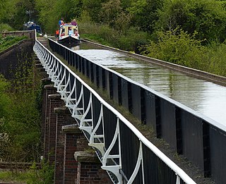
Wyrley and Essington Canal

The Wyrley and Essington Canal, known locally as "the Curly Wyrley", is a canal in the English Midlands. As built it ran from Wolverhampton to Huddlesford Junction near Lichfield, with a number of branches: some parts are currently derelict. Pending planned restoration to Huddlesford, the navigable mainline now terminates at Ogley Junction near Brownhills. In 2008 it was designated a Local Nature Reserve.

Llangollen Canal

The Llangollen Canal is a navigable canal crossing the border between England and Wales. The waterway links Llangollen in Denbighshire, north Wales, with Hurleston in south Cheshire, via the town of Ellesmere, Shropshire. The name, which was coined in the 1980s, is a modern designation for parts of the historic Ellesmere Canal and the Llangollen navigable feeder, both of which became part of the Shropshire Union Canals in 1846.

Montgomery Canal

The Montgomery Canal, known colloquially as "The Monty", is a partially restored canal in eastern Powys and northwest Shropshire. The canal runs 33 miles (53 km) from the Llangollen Canal at Frankton Junction to Newtown via Llanymynech and Welshpool and crosses the England–Wales border.

Hatherton Canal

The Hatherton Canal is a derelict branch of the Staffordshire and Worcestershire Canal in south Staffordshire, England. It was constructed in two phases, the first section opening in 1841 and connecting the main line to Churchbridge, from where a tramway connected to the Great Wyrley coal mines. The second section was a joint venture with the Birmingham Canal Navigations, and linked Churchbridge to the Cannock Extension Canal by a flight of 13 locks, which were opened with the Extension Canal in 1863. The coal traffic was very profitable, and the canal remained in use until 1949. It was formally abandoned in 1955, after which the Churchbridge flight and much of the Extension Canal were destroyed by open cast mining.

Shrewsbury Canal

The Shrewsbury Canal was a canal in Shropshire, England. Authorised in 1793, the main line from Trench to Shrewsbury was fully open by 1797, but it remained isolated from the rest of the canal network until 1835, when the Birmingham and Liverpool Junction Canal built the Newport Branch from Norbury Junction to a new junction with the Shrewsbury Canal at Wappenshall. After ownership passed to a series of railway companies, the canal was officially abandoned in 1944; many sections have disappeared, though some bridges and other structures can still be found. There is an active campaign to preserve the remnants of the canal and to restore the Norbury to Shrewsbury line to navigation.

New Junction Canal

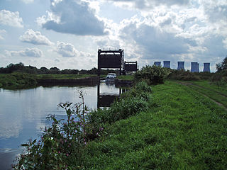
The New Junction Canal is a canal in South Yorkshire, England. It is part of the Sheffield and South Yorkshire Navigation (S&SYN), although it was jointly funded by the Aire and Calder Navigation, and was opened in 1905. It links the River Don Navigation and the Stainforth and Keadby Canal with the Aire and Calder Navigation. It is completely straight, and was the last canal built in England for commercial purposes.

River Sow

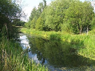
The River Sow is a tributary of the River Trent in Staffordshire, England, and is the river that flows through Stafford.

Stourbridge Canal

The Stourbridge Canal is a canal in the West Midlands of England. It links the Staffordshire and Worcestershire Canal with the Dudley Canal, and hence, via the Birmingham Canal Navigations, to Birmingham and the Black Country.

Dudley Canal

The Dudley Canal is a canal passing through Dudley in the West Midlands of England. The canal is part of the English and Welsh connected network of navigable inland waterways, and in particular forms part of the popular Stourport Ring narrowboat cruising route.

Westport Canal

The Westport Canal was built in the late 1830s to link Westport and Langport in Somerset, England. It was part of a larger scheme involving improvements to the River Parrett above Burrow Bridge. Langport is the point at which the River Yeo joins the River Parrett and the intention was to enable trade via the port at Bridgwater. It remained in use until the 1870s, but closed when the Somerset Drainage Commissioners took over control of the River Parrett. Despite a petition against closure by local people, the Commissioners ruled that navigation of the canal must cease due to their interpretation of the Act which gave them control of it, leaving the canal to serve as a drainage channel since 1878.

Baswich Estate on the south eastern side of Stafford

Baswich is an estate on the south eastern side of Stafford. It is part of the civil parish of Berkswich and is in Staffordshire, England. It is situated next to Weeping Cross, which is also part of the civil parish.

Haywood Junction

Haywood Junction, or Great Haywood Junction, is the name of the canal junction where the Staffordshire and Worcestershire Canal terminates and meets the Trent and Mersey Canal near to the village of Great Haywood, Staffordshire, England.

Cannock Extension Canal

The current Cannock Extension Canal is a 1.8-mile (2.9 km) canal in England. It runs from Pelsall Junction on the Wyrley and Essington Canal, north to Norton Canes Docks and forms part of the Birmingham Canal Navigations. Historically, it ran to Hednesford, and served a number of collieries, which provided the main traffic. It opened in 1863, and the northern section closed in 1963, as a result of mining subsidence.

The BCN Main Line, or Birmingham Canal Navigations Main Line describes the evolving route of the Birmingham Canal between Birmingham and Wolverhampton in England.

Itchen Navigation Disused canal system in Hampshire, England

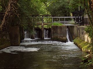
The Itchen Navigation is a 10.4-mile (16.7 km) disused canal system in Hampshire, England, that provided an important trading route from Winchester to the sea at Southampton for about 150 years. Improvements to the River Itchen were authorised by Act of Parliament in 1665, but progress was slow, and the navigation was not declared complete until 1710. It was known as a navigation because it was essentially an improved river, with the main river channel being used for some sections, and cuts with locks used to bypass the difficult sections. Its waters are fed from the River Itchen. It provided an important method of moving goods, particularly agricultural produce and coal, between the two cities and the intervening villages.

Four Counties Ring

The Four Counties Ring is a canal ring which links the four English counties of Cheshire, Staffordshire, Shropshire and the West Midlands.

River Don Navigation Waterway navigation in South Yorkshire, England

The River Don Navigation was the result of early efforts to make the River Don in South Yorkshire, England, navigable between Fishlake and Sheffield. The Dutch engineer Cornelius Vermuyden had re-routed the mouth of the river in 1626, to improve drainage, and the new works included provision for navigation, but the scheme did not solve the problem of flooding, and the Dutch River was cut in 1635 to link the new channel to Goole. The first Act of Parliament to improve navigation on the river was obtained in 1726, by a group of Cutlers based in Sheffield; the Corporation of Doncaster obtained an Act in the following year for improvements to the lower river. Locks and lock cuts were built, and, by 1751, the river was navigable to Tinsley.

Rumer Hill Junction

Rumer Hill Junction was a canal junction on the Cannock Extension Canal where the Churchbridge Branch left to join the Hatherton Canal. The junction, along with the northern section of the canal was abandoned in 1963. The Churchbridge Branch and Rumer Hill Junction were subsequently obliterated by opencast mining.

References

  1. "Stafford Riverway Link". Inland Waterways Association. Archived from the original on 4 July 2010. Retrieved 10 December 2011.CS1 maint: discouraged parameter (link)
  2. Hadfield 1985 , p. 50
  3. 1 2 3 4 5 6 7 8 9 Jones 2006
  4. 1 2 3 4 Hadfield 1985 , p. 130
  5. Ordnance Survey, 1:10,560 map, 1938
  6. Ordnance Survey, 1:10,000 map, 1973-1990
  7. Squires 2008, p. 85.
  8. Squires 2008, p. 157.
  9. "Company Details". Companies House. Retrieved 10 December 2011.CS1 maint: discouraged parameter (link)
  10. Potter 2012, p. 73.
  11. "Planning approval for next stage of Stafford Riverway Link". Waterways World. February 2021. p. 21. ISSN   0309-1422.
  12. 1 2 3 4 Ordnance Survey, 1:2500 map, 1901
  13. Ordnance Survey, 1:10,000 map, 1981