Stourbridge Extension Canal

Last updated

Stourbridge Extension Canal
Junction Footbridge - geograph.org.uk - 3551340.jpg
The stub of the Extension Canal turns off the Stourbridge Canal feeder, and passes under the towpath bridge
Specifications
Locksnone
Statussmall part extant
History
Principal engineerWilliam Fowler, Benjamin Townshend, William Richardson
Date of actJune 1837
Date completed1840
Date closed1935
Geography
Connects to Stourbridge Canal feeder
Stourbridge Extension Canal
BSicon gKHSTa.svg
Sandhills Branch terminus
BSicon gKHSTaq.svg
BSicon gFABZgr+r.svg
Branch
BSicon exCONTgq.svg
BSicon gemKRZu.svg
BSicon exCONTfq.svg
Private Railway siding
BSicon gKHSTaq.svg
BSicon gFABZgr+r.svg
Branch
BSicon gSKRZ-Yu.svg
B4175 bridge
BSicon gFABZgl+l.svg
BSicon gKHSTeq.svg
Branch
BSicon gSTR.svg
BSicon exPUMPHOUSE.svg
Shut End Ironworks
BSicon gemKRZu.svg
Bradleys Incline
BSicon gFABZgl+l.svg
BSicon gKHSTeq.svg
Branch
BSicon gemKRZu.svg
Fosters Incline
BSicon gSKRZ-Au.svg
A4101 bridge
BSicon gSTR+l.svg
BSicon gFABZgr+r.svg
BSicon gSTRl.svg
BSicon gSTR.svg
BSicon exPUMPHOUSE.svg
Corbyn's Hall Ironworks
BSicon gFABZgl+l.svg
BSicon gKHSTeq.svg
Branch to factory
BSicon exCONTgq.svg
BSicon gemKRZu.svg
BSicon exCONTfq.svg
Private Railway siding
BSicon gSKRZ-Yu.svg
Bromley Lane bridge
BSicon gKHSTa.svg
BSicon gSTR.svg
Bromley Basin
BSicon gSTRl.svg
BSicon gFABZgr+r.svg
Bromley Branch
BSicon ugFGATEu.svg
Stop lock
BSicon guENDE.svg
Infilled above here
BSicon uddSTRr.svg
Moorings
BSicon uSTRq.svg
BSicon uFABZqlr.svg
BSicon uSTRq.svg
Brockmoor Jn

The Stourbridge Extension Canal was a short canal built to serve a number of mines in the Kingswinford area of Staffordshire in England. Although connected to the Stourbridge Canal, it was independent from it. It opened in 1840, and was abandoned in 1935. A short section of it is still used as moorings for boats using the Stourbridge Canal.

Contents

History

In the 1820s, a number of coal mines opened up in the Kingswinford area, which was just to the north-west of the Fens branch of the Stourbridge Canal. Although a survey was carried out by Samuel Hodgekinson for a canal or a railway to service the mines, no definite proposals emerged. Gibbons and Co., owners of the first mine to open, built a tramway to Brockmoor in 1825, and a railway from the Staffordshire and Worcestershire Canal was constructed by Lord Dudley, which opened in 1829, but there were further plans for both canals and railways to the area of Shutt End. The Stourbridge Canal company then proposed an extension of their canal to Shutt End, but the scheme was opposed by Lord Dudley, and was not pursued. [1] In 1836, the Stourbridge, Wolverhampton & Birmingham Junction Canal was proposed by a group of businessmen, including some of the Stourbridge Canal shareholders, who formed a separate company. This would have started near Fens Pool on the Stourbridge Canal and run via the mines at Shutt End to Straits Green and Cotwallend, before passing through a 1-mile (1.6 km) tunnel at Bloomfield to reach the Birmingham Canal Navigations main line near Factory Junction, where Thomas Telford's new main line left the old one. This did not meet with general approval, with opposition from Lord Dudley, the Dudley Canal company, the Staffordshire and Worcestershire Canal and the Birmingham Canal Navigation, and the company were unable to raise the £125,000 capital required for the project. Consequently, when they obtained an Act of Parliament in June 1837, to authorise the work, it was for a much smaller scheme, running from Brockmoor to Oak Farm, just beyond Shutt End. One concession made was that they promised to buy the tramway which ran from Corbyn Hall to Brockmoor once the canal was operational. [2]

Construction of the canal began in June 1837 with William Fowler as the engineer, who was replaced by Benjamin Townshend in September 1838, who had himself been replaced by William Richardson by the time construction was completed. The main contractor was James Frost, who was from Wednesbury. The canal was all on one level, with a stop lock at its junction with the Stourbridge Canal, and the length of the main line was about 2 miles (3.2 km). It was completed in 1840, opening on 27 June, and had cost £49,000, including £3,000 to purchase the tramway, which was paid for in 1841. The Sandhills Branch, which ran for 0.6 miles (0.97 km) from the main line to wharves and limekilns on the Kinswinford to Sandhills, was opened later in 1840. The 0.3-mile (0.48 km) Bromley Branch left the main line a little above the stop lock, and opened in 1841, although it was not authorised by the enabling Act. The canal was a success, [3] with good amounts of iron ore and limestone being carried to blast furnaces, and finished iron and coal being exported to the wider region. [4]

The coming of the railways

The canal was barely open, when the railways posed a threat. The Oxford, Worcester and Wolverhampton Railway was active in the area, and in 1845 applied for an Act of Parliament to authorise a number of routes, one of which would run along the banks of the canal. An agreement was reached, whereby the Railway Company would buy the canal if the Act was granted. It was, and the canal passed into the hands of the Railway Company on 27 March 1847. Unlike many such takeovers, the Act specified that the canal was to be well maintained, that tolls were not to be raised so that the canal became uncompetitive, and gave powers to the Treasury or other government departments to intervene if the railway company did not run the canal in the public interest. The railway company paid £49,000 for the canal, and it provided one of the two sources of income to the new company, the other being the Stratford and Moreton Tramway, which they leased under the powers of the Act. The canal thrived, carrying an average of 502,013 tons per year between 1850 and 1859, and seeing its profits trebling from £1,331 to £3,532 over the same period. [5] By the 1850s, the canal served two brickworks, four collieries, and six ironworks, which operated a total of seventeen blast furnaces. [4]

When the Oxford, Worcester and Wolverhampton Railway became part of the West Midland Railway and then the Great Western Railway, the canal also had new owners. Despite its short length, and the fact that much of the traffic travelled less than a mile on the canal, the canal still made a profit, and it was not until the early 1900s that traffic started to decline. The canal was finally abandoned in 1935. [4]

Today

Most of the canal was filled in after its abandonment. A trading estate covers most of the northern end of the Sandhill Branch, and housing has been built over the middle section. A short stub, from the Brockmoor Junction with the Stourbridge Canal to the stop lock at Bromley has been retained in water, and mooring facilities with a boundary fence were constructed by British Waterways on the north bank of the stub in 2004. [6]

See also

Bibliography

Related Research Articles

<span class="mw-page-title-main">Staffordshire and Worcestershire Canal</span> Canal in the West Midlands, England

The Staffordshire and Worcestershire Canal is a navigable narrow canal in Staffordshire and Worcestershire in the English Midlands. It is 46 miles (74 km) long, linking the River Severn at Stourport in Worcestershire with the Trent and Mersey Canal at Haywood Junction by Great Haywood.

<span class="mw-page-title-main">Wyrley and Essington Canal</span> Narrow canal in the Midlands, England

The Wyrley and Essington Canal, known locally as "the Curly Wyrley", is a canal in the English Midlands. As built it ran from Wolverhampton to Huddlesford Junction near Lichfield, with a number of branches: some parts are currently derelict. Pending planned restoration to Huddlesford, the navigable mainline now terminates at Ogley Junction near Brownhills. In 2008 it was designated a Local Nature Reserve.
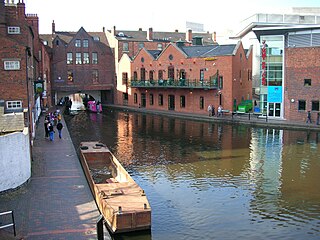
<span class="mw-page-title-main">Brierley Hill</span> Human settlement in England

Brierley Hill is a town and electoral ward in the Metropolitan Borough of Dudley, West Midlands, England, 3 miles south of Dudley and 1 mile north of Stourbridge. Part of the Black Country and in a heavily industrialised area, it has a population of 13,935 at the 2011 census. It is best known for glass and steel manufacturing, although industry has declined considerably since the 1970s. One of the largest factories in the area was the Round Oak Steelworks, which closed down and was redeveloped in the 1980s to become the Merry Hill Shopping Centre. Brierley Hill was originally in Staffordshire.

<span class="mw-page-title-main">Dudley Tunnel</span>

Dudley Tunnel is a canal tunnel on the Dudley Canal Line No 1, England. At about 3,172 yards (2,900.5 m) long, it is now the second longest canal tunnel on the UK canal network today.. However, since the Dudley Tunnel is not continuous this status is sometimes questioned:.

<span class="mw-page-title-main">Shropshire Union Railways and Canal Company</span>

The Shropshire Union Railways and Canal Company was a Company in England, formed in 1846, which managed several canals and railways. It intended to convert a number of canals to railways, but was leased by the London and North Western Railway (LNWR) from 1847, and although they built one railway in their own right, the LNWR were keen that they did not build any more. They continued to act as a semi-autonomous body, managing the canals under their control, and were critical of the LNWR for not using the powers which the Shropshire Union Company had obtained to achieve domination of the markets in Shropshire and Cheshire by building more railways.

<span class="mw-page-title-main">Stourbridge Canal</span> Canal in England

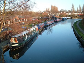
The Stourbridge Canal is a canal in the West Midlands of England. It links the Staffordshire and Worcestershire Canal with the Dudley Canal, and hence, via the Birmingham Canal Navigations, to Birmingham and the Black Country.

<span class="mw-page-title-main">Dudley Canal</span> Canal in the West Midlands, England

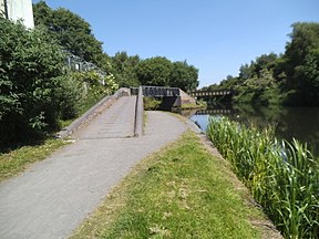
The Dudley Canal is a canal passing through Dudley in the West Midlands of England. The canal is part of the English and Welsh network of connected navigable inland waterways and forms part of the popular Stourport Ring narrowboat cruising route.

The Oxford, Worcester and Wolverhampton Railway (OW&WR) was a railway company in England. It built a line from Wolvercot Junction near Oxford to Worcester, Stourbridge, Dudley and Wolverhampton, as well as some branches.

<span class="mw-page-title-main">Brettell Lane railway station</span> Disused railway station in Dudley

Brettell Lane railway station was a station on the Oxford-Worcester-Wolverhampton Line which served the town of Brierley Hill in England.

<span class="mw-page-title-main">Wombourne branch line</span>

The Wombourne branch was a railway situated in the West Midlands, England. It branched from the Great Western Railway's Oxford, Worcester and Wolverhampton line at Kingswinford Junction to the north of Brettell Lane railway station and joined the same company's Shrewsbury to Wolverhampton line at the triangular Oxley Junction on the north-western approach to Wolverhampton Low Level.

<span class="mw-page-title-main">Aldersley Junction</span> Canal junction

Aldersley Junction is the name of the canal junction where the Birmingham Main Line Canal terminates and meets the Staffordshire and Worcestershire Canal near to Oxley, north Wolverhampton, West Midlands, England. It opened in 1772.

<span class="mw-page-title-main">Cannock Extension Canal</span>

The current Cannock Extension Canal is a 1.8-mile (2.9 km) canal in England. It runs from Pelsall Junction on the Wyrley and Essington Canal, north to Norton Canes Docks and forms part of the Birmingham Canal Navigations. Historically, it ran to Hednesford, and served a number of collieries, which provided the main traffic. It opened in 1863, and the northern section closed in 1963, as a result of mining subsidence.

<span class="mw-page-title-main">Horseley Fields Junction</span>

Horseley Fields Junction is a canal junction at the western limit of the Wyrley and Essington Canal where it meets the BCN Main Line, at Horseley Fields east of Wolverhampton, in the West Midlands, England.

<span class="mw-page-title-main">Ogley Junction</span> Canal junction in the English Midlands

Ogley Junction, on the Staffordshire county border near Brownhills, West Midlands, England, is a historic canal junction on the Wyrley and Essington Canal where the Anglesey Branch left the main line.

<span class="mw-page-title-main">Pelsall Junction</span> Canal junction in England

Pelsall Junction is a canal junction at the southern limit of the Cannock Extension Canal where it meets the Wyrley and Essington Canal main line, near Pelsall, West Midlands, England.

<span class="mw-page-title-main">Ridgacre Branch</span> UK canal

The Ridgacre Branch is a canal branch of the Wednesbury Old Canal, part of the Birmingham Canal Navigations, in the West Midlands, England. It opened in 1828, to serve collieries and iron works, and was disused by the 1960s. Except for its branches and a small section at the eastern end, which have been filled in, most of it is still in water, but it is not navigable as a low-level bridge carrying the Black Country New Road spans the entrance.

<span class="mw-page-title-main">Wednesbury Oak Loop</span>

The Wednesbury Oak Loop, sometimes known as the Bradley Arm, is a canal in the West Midlands, England. It is part of the Birmingham Canal Navigations (BCN), and was originally part of James Brindley's main line, but became a loop when Thomas Telford's improvements of the 1830s bypassed it by the construction of the Coseley Tunnel. The south-eastern end of the loop was closed and in parts built over, following the designation of the entire loop as "abandoned" in 1954, including the section which was filled in at the beginning of the 1960s to make way for the Glebefields Estate in Tipton.

<span class="mw-page-title-main">Birmingham and Liverpool Junction Canal</span>

The Birmingham and Liverpool Junction Canal was a canal in England which ran from Nantwich, where it joined the Chester Canal, to Autherley, where it joined the Staffordshire and Worcestershire Canal. Forming part of a major link between Liverpool and the industrial heartlands of the Midlands, the canal was opened in 1835, and merged with the Ellesmere and Chester Canal Company in 1845, which became the Shropshire Union Railways and Canal Company in the following year.

<span class="mw-page-title-main">Pensnett Canal</span>

The Pensnett Canal, also called Lord Ward's Canal was a private 1.25 miles (2 km) long canal near Brierley Hill, West Midlands, England, which opened in 1840 and served the industrial enterprises of Lord Dudley's Estate. The engineer was Mathew Frost. Since its closure to navigation in 1950, much of it has been lost by overbuilding, but a small section at its junction with the Dudley Canal was restored in 1995, and the section through Brierley Hill remains in water, although it is polluted and not navigable.

John Bradley & Co was a company established in 1800 by John Bradley at Stourbridge in the West Midlands area of England. The company developed into a large industrial concern with furnaces, ironworks and mines. Under James Foster, John Bradley's half brother, it was instrumental in bringing the first commercial steam locomotive into the Midlands area in 1829. The firm stayed under family control until the early years of the 20th century when first the mining (1913) and then the ironworks (1919) were sold off. Part of the business continued to trade under the name John Bradley & Co. (Stourbridge) Ltd until after the Second World War.

References

  1. Hadfield 1985 , p. 103
  2. Hadfield 1985 , pp. 103–105
  3. Hadfield 1985 , pp. 105–106
  4. 1 2 3 "Canals: Dudley and Stourbridge". Birmingham City Council. Archived from the original on 30 September 2011. Retrieved 1 February 2012.
  5. Hadfield 1985 , pp. 266–267
  6. "2004 tour cruising record and pictures". Tuesday Night Club. Archived from the original on 18 May 2011.

52°29′14″N2°08′14″W / 52.4872°N 2.1373°W / 52.4872; -2.1373