Hackney Canal

Last updated

Hackney Canal
Hackney Canal Bridge - geograph.org.uk - 1870031.jpg
The railway bridge over the entrance to the canal. The lock was just beyond the bridge.
Specifications
Locks1
Statusmostly filled in
History
Date of actPrivately built
Date of first use1843
Date closed1928
Geography
Start pointHackney Clay Cellars
End point River Teign
Hackney Canal
BSicon FEATURE.svg
Hackney Clay Cellars
BSicon ugHWHRF.svg
BSicon gSTRq.svg
BSicon gSTR+r.svg
Hackney Wharf
BSicon BUILDINGl.svg
BSicon gTEEnl.svg
Newton Abbot Pottery + Feeder
BSicon gSTR.svg
BSicon gSTR.svg
BSicon exSTR+l.svg
BSicon exSTRq.svg
BSicon gemKRZu.svg
BSicon exSTR+r.svg
Newton Abbot racecource
BSicon exSTRl.svg
BSicon exSTRq.svg
BSicon gemKRZu.svg
BSicon exSTRr.svg
BSicon ugLock5.svg
Hackney Lock
BSicon CONTgq.svg
BSicon uxmKRZu.svg
BSicon CONTfq.svg
Teignmouth - Newton Abbot Rly
BSicon uexSTR+l.svg
BSicon uexFABZqlr.svg
BSicon uexSTR+r.svg
Hackney Channel
BSicon uexSTRq.svg
BSicon uexABZqr.svg
BSicon uexSTRq.svg
BSicon uexABZql.svg
BSicon uexSTRq.svg
River Teign Whitelake Channel

The Hackney Canal was a short canal in Devon, England, that linked the Hackney Clay Cellars to the River Teign. It was privately built by Lord Clifford in 1843, and throughout its life carried ball clay for use in the production of pottery. It closed in 1928, when its function was replaced by road vehicles.

Contents

History

The area to the north of the River Teign, particularly near to Chudleigh Knighton, Kingsteignton and Preston, was an important source of ball clay in the eighteenth and nineteenth centuries. Most of the extraction sites were owned by Lord Clifford, who lived at Ugbrooke House. The clay was taken to Hackney Clay Cellars for drying, and was then transferred to Teignmouth by packhorse, where it was loaded into coasters for delivery to the pottery industry. The situation was far from ideal, particularly as the Teignmouth moorings were tidal, and the high tidal range made loading difficult. [1]

In order to improve the situation, Lord Clifford built a canal to link the clay pits to the River Teign. Its terminus was close to the Newton Abbot to Kingsteignton road. The canal opened on 17 March 1843. [2] It was 0.6 miles (0.97 km) long, and had a single lock where it joined the river [3] that was 108 by 14 feet (32.9 by 4.3 m), with a depth of 3.75 feet (1.14 m) over the lower cill. [1] The wooden boats which sailed on the estuary were around 50 feet (15 m) long and 14 feet (4.3 m) wide, with a flat bottom, a rounded bow and a flat transom stern. They were fitted with a single square sail, like a Viking longboat, and in many respects were very similar to the Humber keels which plied the waterways of the north east of England. [4] The length of the lock enabled two boats to use it at the same time. [1]

In 1844 the South Devon Railway Company built a bridge over the canal, with the harbour commissioners of the port of Teignmouth retaining John Rennie to ensure that, among other things, the bridge over the canal was large enough to allow boat traffic to continue. [2]

In 1858, the Newton and Moretonhampstead Railway was authorised, although the company was reconstituted as the Moretonhampstead and South Devon Railway in 1861, before any work began. It was effectively owned by the South Devon Railway. The neighbouring Stover Canal negotiated with the company, and they bought out the canal for £8,000 in 1862. A month after the acquisition, the minutes recorded a letter from Watts, Blake and Company, who traded on that canal, asking what price they would be willing to sell the canal for, as they believed the directors intended to dispose of it. Although there is no record of the railway company buying the Hackney Canal, a letter was received at the same time from Mr Whiteway, acting on behalf of a Mr Knight who held the lease for the Hackney Canal, asking much the same question. The railway company agreed to notify both parties that no decisions had been made to dispose of their canal interests. [5]

Decline

The canal ceased to be used in 1928. [3] Since the terminus was next to a main road, the advent of the motor lorry resulted in its closure. The basin was briefly used by a company building yachts in 1954, but they resorted to sending the completed boats to Teignmouth by lorry, and moved to Brixham soon afterwards. A wall was constructed around the lock in 1955 after high tides in the estuary broke through and flooded Newton Abbot Racecourse. [6]

Route

The terminus was close to the Kingsteignton road, and consisted of a basin with buildings on both sides. The basin was filled in to enable lorries to turn, [7] and the buildings were for many years used by A J Booker's Autobodies as a car body workshop. [8] Although they were grade II listed structures, all except one were demolished in 2001 as part of a redevelopment of the area. [9] The tow-path followed the north bank of the canal, and the water supply entered the canal from a leat which passed under the tow-path to the east of the wharf buildings, [7] crossing over a drainage ditch on an aqueduct before it did so. To the south of the wharf area was Newton Abbot Potteries, built before 1905, and labelled "Bricks and Pipes" on the 1956 map. [10] After a short distance, the canal turned to the south-east, and followed a nearly straight line across what is now the end of Newton Abbot racecourse. In 1969, the end of the racetrack followed the west bank of the canal, [11] but by 1989 the track had been extended across the site of the canal. A drainage ditch crosses the area, which gives an indication of where the canal was, since the ditch was on the west side of the canal before it was filled in. [12] Just beyond the second crossing by the race track are the remains of the lock and the wall which prevents the Teign flooding the area. The route turns to the east, to pass under the railway line, and joins the Hackney channel of the River Teign. [13]

Map showing the short Hackney Canal in relation to some other relevant features Templer transport map.svg
Map showing the short Hackney Canal in relation to some other relevant features

Points of interest

Map all coordinates using: OpenStreetMap  
Download coordinates as: KML

See also

Bibliography

Related Research Articles

<span class="mw-page-title-main">River Teign</span> River in Devon, England

The River Teign is a river in the county of Devon, England. It is 31 mi (50 km) long and rises on Dartmoor, becomes an estuary just below Newton Abbot and reaches the English Channel at Teignmouth.

<span class="mw-page-title-main">Teignmouth</span> Town in Devon, England

Teignmouth is a seaside town, fishing port and civil parish in the English county of Devon. It is situated on the north bank of the estuary mouth of the River Teign, about 12 miles south of Exeter. The town had a population of 14,749 at the last census in 2011.

<span class="mw-page-title-main">Teignbridge</span> Non-metropolitan district in England

Teignbridge is a local government district in Devon, England. Its council is based in Newton Abbot.

<span class="mw-page-title-main">Newton Abbot</span> Town in Teignbridge District, Devon, England

Newton Abbot is a market town and civil parish on the River Teign in the Teignbridge District of Devon, England. Its 2011 population of 24,029 was estimated to reach 26,655 in 2019. It grew rapidly in the Victorian era as the home of the South Devon Railway locomotive works. This later became a major steam engine shed, retained to service British Railways diesel locomotives until 1981. It now houses the Brunel industrial estate. The town has a race course nearby, the most westerly in England, and a country park, Decoy. It is twinned with Besigheim in Germany and Ay in France.

<span class="mw-page-title-main">Riviera Line</span> Railway line in Devon, England

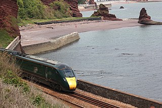
The Riviera Line is the railway between the city of Exeter, towns Dawlish and Teignmouth, and the English Riviera resorts of Torbay in Devon, England. Its tracks are shared with the Exeter to Plymouth Line along the South Devon sea wall. It is part of the Network Rail Route 12.

<span class="mw-page-title-main">Teignbridge (UK Parliament constituency)</span> Former UK Parliament constituency

Teignbridge was, from 1983 until 2010, a county constituency represented in the House of Commons of the Parliament of the United Kingdom. It elected one Member of Parliament (MP) by the first past the post system of election.

<span class="mw-page-title-main">Kingsteignton</span> Town in Devon, England

Kingsteignton, is a town and civil parish in South Devon, England. It lies at the head of the Teign Estuary to the west of Teignmouth in the Teignbridge district. It is bypassed by the A380 and is also on the A383, A381, B3193 and B3195. Kingsteignton is currently represented in parliament by Anne Marie Morris, as part of the Newton Abbot Constituency.The local education centers (schools) include : Rydon Primary School, Teign School and Saint Michael's School Church of England School.

<span class="mw-page-title-main">Stainforth and Keadby Canal</span> Canal in Yorkshire and Lincolnshire, England

The Stainforth and Keadby Canal is a navigable canal in South Yorkshire and Lincolnshire, England. It connects the River Don Navigation at Bramwith to the River Trent at Keadby, by way of Stainforth, Thorne and Ealand, near Crowle. It opened in 1802, passed into the control of the River Don Navigation in 1849, and within a year was controlled by the first of several railway companies. It became part of the Sheffield and South Yorkshire Navigation, an attempt to remove several canals from railway control, in 1895. There were plans to upgrade it to take larger barges and to improve the port facilities at Keadby, but the completion of the New Junction Canal in 1905 made this unnecessary, as Goole could easily be reached and was already a thriving port.
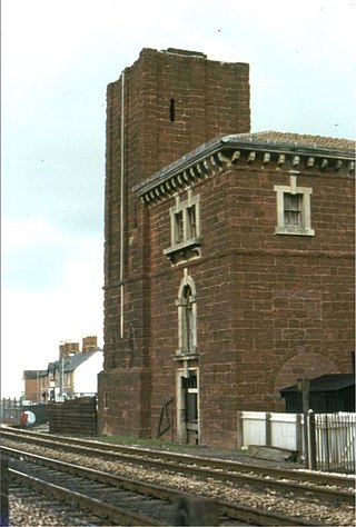
<span class="mw-page-title-main">South Devon Railway sea wall</span> Sea wall on the south coast of Devon, England

The South Devon Railway sea wall is situated on the south coast of Devon in England. A footpath runs alongside the railway between Dawlish Warren and Dawlish, then another footpath forms a continuation to the sea front promenade at Teignmouth. Both of these form part of the South West Coast Path.

The Moretonhampstead and South Devon Railway was a 7 ft 14 in broad gauge railway which linked the South Devon Railway at Newton Abbot railway station with Bovey, Lustleigh and Moretonhampstead, Devon, England.

<span class="mw-page-title-main">Heathfield railway station (Devon)</span> Disused railway station in Devon, England

Heathfield railway station, originally Chudleigh Road railway station before the Teign Valley Line opened, was on the Moretonhampstead and South Devon Railway at Heathfield, nearly 4 miles from Newton Abbot, Devon, England.

<span class="mw-page-title-main">Stover Canal</span> Derelict canal in Devon, England

The Stover Canal is a canal located in Devon, England. It was opened in 1792 and served the ball clay industry until it closed in the early 1940s. Today it is derelict, but the Stover Canal Society is aiming to restore it and reopen it to navigation.

<span class="mw-page-title-main">Haytor Granite Tramway</span> Horse-drawn tramway built to convey granite (1820-1858)

The Haytor Granite Tramway was a tramway built to convey granite from Haytor Down, Dartmoor, Devon to the Stover Canal. It was very unusual in that the track was formed of granite sections, shaped to guide the wheels of horse-drawn wagons.

<span class="mw-page-title-main">A381 road</span> Road in Devon, England

The A381 road is a non-trunk 'A'-class road in Devon, England which serves as an important link between the towns of Teignmouth, Kingsteignton, Newton Abbot, Totnes and Salcombe and many villages in between, with the busiest section having 6 lanes and carrying an average of over 40,000 vehicles per day. The route overlaps with other A-roads for several sections of its length. It is a faster route from Teignmouth to Salcombe than the A379 which meets it at both ends. It is under the control of Devon County Council as highway authority.

<span class="mw-page-title-main">Chudleigh Knighton Halt railway station</span> Disused railway station in Devon, England

Chudleigh Knighton Halt was on the Teign Valley Line serving the small village of Chudleigh Knighton, Devon, England. The halt, built by the Great Western Railway at a later date than most of the other stations on the line, was located on the west side of Pipehouse Lane off the B3344, to the south of the village.

<span class="mw-page-title-main">Exeter–Plymouth line</span> Railway line in Devon, England

The Exeter–Plymouth line, also called the South Devon Main Line, is a central part of the trunk railway line between London Paddington and Penzance in the southern United Kingdom. It is a major branch of the Great Western Main Line and runs from Exeter St Davids to Plymouth, from where it continues as the Cornish Main Line. It was one of the principal routes of the Great Western Railway which in 1948 became part of the Western Region of British Railways and are now part of the Network Rail system.

<span class="mw-page-title-main">James Templer (canal builder)</span> British canal builder

James Templer (1748–1813) of Stover House, Teigngrace, Devon, was a Devon landowner and the builder of the Stover Canal.

<span class="mw-page-title-main">Teigngrace</span>

Teigngrace is a civil parish centred on a hamlet that lies about two miles north of the town of Newton Abbot in Devon, England. According to the 2001 census, its population was 235, compared to 190 a century earlier. The western boundary of the parish mostly runs along the A382 road; its short northern boundary along the A38; and its eastern partly along the rivers Bovey and Teign. It comes to a point at its southern extremity, near Newton Abbot Racecourse. The parish is surrounded, clockwise from the north, by the parishes of Bovey Tracey, Kingsteignton, Newton Abbot and a small part of Ilsington.

<span class="mw-page-title-main">Hackney Marshes, Devon</span> Nature reserve in Devon, England

Hackney Marshes is a local nature reserve in Devon, England. It comprises a low-lying area of flood meadows located at the head of the Teign Estuary by Kingsteignton.

References

  1. 1 2 3 Ewans 1966 , p. 38
  2. 1 2 Hadfield 1985 , pp. 121–122
  3. 1 2 Hadfield 1985 , p. 190
  4. Ewans 1966 , p. 35
  5. Ewans 1966 , pp. 39–41
  6. Ewans 1966 , p. 49
  7. 1 2 Ewans 1966 , p. 59
  8. Historic England. "Clay Cellars Kingsteighton (1165512)". National Heritage List for England . Retrieved 14 December 2011.
  9. Harris 2010 , p. 3
  10. Ordnance Survey, 1:2500 map, 1905 and 1956
  11. Ordnance Survey, 1:10,560 map, 1969
  12. Ordnance Survey, 1:2500 map, 1956 and 1989
  13. Ewans 1966 , p. 60

Commons-logo.svg Media related to Hackney Canal at Wikimedia Commons