
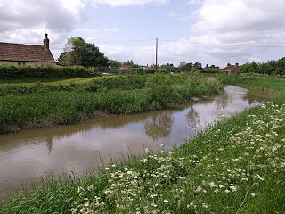
The River Parrett flows through the counties of Dorset and Somerset in South West England, from its source in the Thorney Mills springs in the hills around Chedington in Dorset. Flowing northwest through Somerset and the Somerset Levels to its mouth at Burnham-on-Sea, into the Bridgwater Bay nature reserve on the Bristol Channel, the Parrett and its tributaries drain an area of 660 square miles (1,700 km2) – about 50 per cent of Somerset's land area, with a population of 300,000.

The Calder and Hebble Navigation is a broad inland waterway, with locks and bridge holes that are suitable for 14-foot-wide (4.3 m) boats, in West Yorkshire, England. Construction to improve the River Calder and the River Hebble began in 1759, and the initial scheme, which included 5.7 miles (9.2 km) of new cuts, was completed in 1770 and has remained navigable since it was opened. Significant improvements were made, including the Salterhebble branch to Halifax, opened in 1828, and ever-longer cuts to bypass river sections. Trade was assisted by the opening of the Rochdale Canal in 1804, which provided a through route from Sowerby Bridge to Manchester. There were plans to abandon the river sections completely in the 1830s, but these were modified as the needs of mill owners and other riparian landowners were recognised.
The Stratford-upon-Avon Canal is a canal in the south Midlands of England. The canal, which was built between 1793 and 1816, runs for 25.5 miles (41.0 km) in total, and consists of two sections. The dividing line is at Kingswood Junction, which gives access to the Grand Union Canal. Following acquisition by a railway company in 1856, it gradually declined, the southern section being un-navigable by 1945, and the northern section little better.

The Bridgwater and Taunton Canal is a canal in the south-west of England between Bridgwater and Taunton, opened in 1827 and linking the River Tone to the River Parrett. There were a number of abortive schemes to link the Bristol Channel to the English Channel by waterway in the 18th and early 19th centuries. These schemes followed the approximate route eventually taken by the Bridgwater and Taunton Canal, but the canal was instead built as part of a plan to link Bristol to Taunton by waterway.
The River Tone is a river in the English county of Somerset. The river is about 33 kilometres (21 mi) long. Its source is at Beverton Pond near Huish Champflower in the Brendon Hills, and is dammed at Clatworthy Reservoir. The reservoir outfall continues through Taunton and Curry and Hay Moors, which are designated as a Site of Special Scientific Interest. Finally, it flows into the River Parrett at Burrowbridge.

The River Weaver is a river, navigable in its lower reaches, running in a curving route anti-clockwise across west Cheshire, northern England. Improvements to the river to make it navigable were authorised in 1720 and the work, which included eleven locks, was completed in 1732. An unusual clause in the enabling Act of Parliament stipulated that profits should be given to the County of Cheshire for the improvement of roads and bridges, but the navigation was not initially profitable, and it was 1775 before the first payments were made. Trade continued to rise, and by 1845, over £500,000 had been given to the county.

Ilchester is a village and civil parish, situated on the River Yeo or Ivel, five miles north of Yeovil, in the English county of Somerset. Originally a Roman town, and later a market town, Ilchester has a rich medieval history and was a notable settlement in the county; around the 12th and 13th centuries it was effectively the county town. It had, however, declined in size and importance by the beginning of the 18th century, and the last markets were held in 1833. In 1889 the historic corporation that had governed the town was dissolved.

The Andover Canal was a canal built in Hampshire, England. It ran 22 miles (35 km) from Andover to Redbridge through Stockbridge and Romsey. The canal had a fall of 179 feet (55 m) through 24 locks, and for much of its length paralleled the River Anton and River Test. It opened in 1794, but was never a commercial success. The only dividend paid to shareholders was in 1859, using the proceeds from the sale of the canal to the London and South Western Railway, who bought it to lay a railway line along much of its course. The railway line is now also defunct.

The Blyth Navigation was a canal in Suffolk, England, running 7 miles (11 km) from Halesworth to the North Sea at Southwold. It opened in 1761, and was insolvent by 1884. Its demise was accelerated by an attempt to reclaim saltings at Blythburgh, which resulted in the estuary silting up. It was used sporadically until 1911, and was not formally abandoned until 1934.

The Lichfield Canal, as it is now known, was historically a part of the Wyrley and Essington Canal, being the section of that canal from Ogley Junction at Brownhills on the northern Birmingham Canal Navigations to Huddlesford Junction, east of Lichfield, on the Coventry Canal, a length of 7 miles (11.3 km). The branch was abandoned in 1955, along with several other branches of the Wyrley and Essington, and much of it was filled in.

The Droitwich Canal is a synthesis of two canals in Worcestershire, England; the Droitwich Barge Canal and the Droitwich Junction Canal. The Barge Canal is a broad canal which opened in 1771 linking Droitwich Spa to the River Severn at Hawford Bottom Lock, Claines. The Droitwich Junction Canal is a narrow canal, opened in 1854, which linked Droitwich to the Worcester and Birmingham Canal. Both were built to carry salt, and were abandoned in 1939. They have been the subject of a restoration plan since 1973, and the Barge Canal was officially reopened in 2010, while the Junction Canal reopened in July 2011. Following the opening of the canal, ownership transferred to the newly created Canal and River Trust
The Glastonbury Canal ran for approximately 14 miles (23 km) through two locks from Glastonbury to Highbridge in Somerset, England, where it entered the River Parrett and from there the Bristol Channel. The canal was authorised by Parliament in 1827 and opened in 1834. It was operated by the Glastonbury Navigation and Canal Company. Most of it was abandoned as a navigation in 1854, when a railway was built along the towpath.

The Leven Canal runs for 3.18 miles (5.1 km) from the River Hull to the village of Leven, East Riding of Yorkshire, England. It was built for Mrs Charlotta Bethell in 1805, and remained in use until 1935. It is now a Site of Special Scientific Interest.
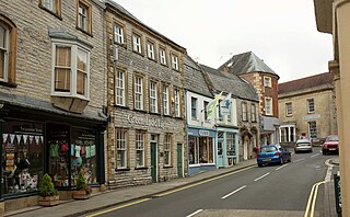
Langport is a town and civil parish in Somerset, England, 5 miles (8 km) west of Somerton. The parish, which covers only part of the town, has a population of 3,578. Langport is contiguous with Huish Episcopi, a separate parish that includes much of the town's outskirts.
The Shrewsbury Canal was a canal in Shropshire, England. Authorised in 1793, the main line from Trench to Shrewsbury was fully open by 1797, but it remained isolated from the rest of the canal network until 1835, when the Birmingham and Liverpool Junction Canal built the Newport Branch from Norbury Junction to a new junction with the Shrewsbury Canal at Wappenshall. After ownership passed to a series of railway companies, the canal was officially abandoned in 1944; many sections have disappeared, though some bridges and other structures can still be found. There is an active campaign to preserve the remnants of the canal and to restore the Norbury to Shrewsbury line to navigation.

The Driffield Navigation is an 11-mile (18-kilometre) waterway, through the heart of the Holderness Plain to the market town of Driffield, East Riding of Yorkshire, England. The northern section of it is a canal, and the southern section is part of the River Hull. Construction was authorised in 1767, and it was fully open in 1770. Early use of the navigation was hampered by a small bridge at Hull Bridge, which was maintained by Beverley Corporation. After protracted negotiation, it was finally replaced in 1804, and a new lock was built to improve water levels at the same time. One curious feature of the new works were that they were managed quite separately for many years, with the original navigation called the Old Navigation, and the new works called the New Navigation. They were not fully amalgamated until 1888.

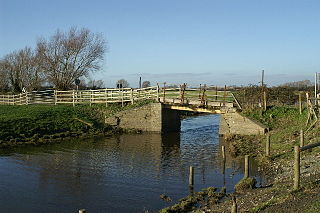
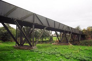
The Westport Canal was built in the late 1830s to link Westport and Langport in Somerset, England. It was part of a larger scheme involving improvements to the River Parrett above Burrow Bridge. Langport is the point at which the River Yeo joins the River Parrett and the intention was to enable trade via the port at Bridgwater. It remained in use until the 1870s, but closed when the Somerset Drainage Commissioners took over control of the River Parrett. Despite a petition against closure by local people, the Commissioners ruled that navigation of the canal must cease due to their interpretation of the Act which gave them control of it, leaving the canal to serve as a drainage channel since 1878.

The Selby Canal is a 6-mile (9.7 km) canal with two locks, which bypasses the lower reaches of the River Aire in Yorkshire, England, from the village of West Haddlesey to the town of Selby where it joins the River Ouse. It opened in 1778, and provided the main outlet for the Aire and Calder Navigation until 1826, when it was bypassed by a new cut from Ferrybridge to Goole. Selby steadily declined after that, although traffic to York still used the canal.

The Wisbech Canal was a broad canal from Wisbech, Isle of Ely in the Fenland area of Cambridgeshire, England. It ran from the River Nene at Wisbech to the Well Creek at Outwell now in Norfolk, which gave access to the River Great Ouse. It was abandoned in 1926 and filled in during the 1970s.
The Parrett Navigation Company was formed to improve river navigation on the River Parrett, Ivelchester and Langport Navigation and linked waterways. Tolls were introduced to pay for the improvements. It was a trading company owned by Vincent Stuckey and Walter Bagehot.
