Rochdale Branch Canal

Last updated

Rochdale Branch Canal
Rochdale canal rochdale branch.jpg
The branch canal heading into Rochdale (in the centre). The route to Hebden bridge is on the right; that to Manchester is behind the photographer.
Rochdale Branch Canal
Specifications
StatusFilled in and built over
History
Original ownerRochdale Canal Company
Date of act1794
Date of first use1798
Date closed1920s
Geography
Start point Rochdale
Connects to Rochdale Canal
Rochdale Branch Canal
BSicon ugWHRF.svg
Richard Street basin
BSicon ugWHRF.svg
BSicon ugWHRF.svg
Basin and wharves
BSicon gSTRl.svg
BSicon gABZg+r.svg
BSicon gABZg+l.svg
BSicon ugHWHRF.svg
Arm and wharves
BSicon gSKRZ-Yu.svg
High Level Road
BSicon gmKRZu.svg
Calder Valley railway line
BSicon gSKRZ-Eu.svg
Halfpenny Bridge
BSicon ugHWHRF.svg
BSicon gFABZgr+r.svg
Bedford Street Mills arm
BSicon gSKRZ-Eu.svg
Crossfield Bridge
BSicon gSTR.svg
BSicon gSKRZ-Yu.svg
Durham Street bridge
BSicon uFABZgl+l.svg
BSicon uSKRZ-Auq.svg
BSicon uFGATEr.svg
A671 + Moss Lower Lock 50
BSicon uSTRq.svg
BSicon uSTRr.svg
Rochdale Canal Main Line

The Rochdale Branch Canal was a branch of the Rochdale Canal in north-west England which led close to Rochdale Town Centre. It was in use from 1794, and was bordered by the landscaped gardens of Lark Mill House on the western bank until the 1850s. A number of industries grew up around the branch, ranging from cotton mills and an iron and brass foundry in the early years, to a bakery and jam manufactory, woollen mills and sawmills later on. The branch declined with the main canal, and was little used after the 1920s, although not officially abandoned until 1952. It was filled in during the 1960s, and the site of the main basins now lies beneath the car park of a retail shopping centre.

Contents

History

The Rochdale Canal was surveyed by John Rennie in June 1791, although he had no experience of building canals at the time. He was chosen because the engineers of choice, William Jessop and Robert Whitworth, did not have time for the project. In August 1791 Rennie was asked to conduct further surveys for a branch to Rochdale, another to Oldham and a third to some limeworks near Todmorden. [1] The canal was authorised by Rochdale Canal Act 1794 (34 Geo. 3. c. 78) on 4 April 1794, which created the Rochdale Canal Company and sanctioned the building of a canal across the Pennines from Sowerby Bridge, where it would join the Calder and Hebble Navigation, to Manchester, where it would connect to the Bridgewater Canal. [2]

Construction of the whole canal would take around 13 years, but sections were opened as and when they became useful, and the Rochdale Branch, which was about half a mile (0.8 km) long, was opened in 1798, from a basin at Richard Street to Halfpenny Bridge. [3] Additional sections were opened in 1799, and the canal was formally opened in 1804, but there seems to be some doubt that it was all constructed, for two more acts of Parliament[ which? ] were obtained in 1804 and 1806 to raise additional finance, and a final one in 1807 to tidy up some loose ends. [2]

Navigation on the main canal had all but ceased by 1927, and the Rochdale Canal Act 1952 (15 & 16 Geo. 6 & 1 Eliz. 2. c. xxxvii) banned public navigation on most of the waterway. [3] It lay dormant for 20 years, but between then and 2002 the waterway was steadily restored and reopened. In 2000, ownership of the canal transferred from the Rochdale Canal Company to British Waterways, [3] but there were no plans to re-open the Rochdale Branch.

The branch was filled in at the end of the 1960s, and a retail shopping centre has been built over the end of the canal, with the former basin serving as the car park. Just a short section from the junction to Durham Street remains in water, and is used as a turning point. [4] However, the line of the canal can still be traced as far as the railway bridge, while Durham Street bridge and Halfpenny Bridge remain. [5] [6] Dating from 1831, Halfpenny Bridge is a grade II listed structure, and is a rare example of a toll bridge crossing a canal. It is constructed of wrought iron and cast iron, with York stone paving. The footbridge was restored in 1978, and the bridge carries a plaque to commemorate this. [7]

Industry

The canal viewed from Halfpenny Bridge in 1955 View from Halfpenny Bridge, Rochdale Branch Canal - geograph.org.uk - 1322716.jpg
The canal viewed from Halfpenny Bridge in 1955

The branch acted as a centre for industry. In 1851, Durham Street Bridge had yet to be built, but Crossfield Bridge crossed the canal just below the Bedford Street Mills arm. Nothing had been built to the west of the canal or on either side of Bedford Street Mills arm, but to the east of the canal, there were houses at the bottom, and above that, Oldham Road Mill, which was a cotton spinning mill and Soho Foundry, which was an iron and brass foundry. [8] By 1892, Collinge Street had been built, and Durham Street Bridge carried it over the canal. Cotton mills had been built on the west side of the junction with the Rochdale Canal, and Crossfield Bridge had been removed, as the rest of the west bank up to the arm was now occupied by Grove Cotton Mills. Oldham Road Mill had been replaced by a larger building housing Victoria Woolen Mill, and the iron and brass foundry had been split to become Soho Woollen Mill and Soho Iron Foundry. [9] In 1910, the mills at the start of the branch can be identified as the Norwich Street Mills, and both of the Soho works have become the Soho Iron Works, [10] which was still the case in 1930. [11] By 1958, most of the buildings are just labelled "works", and so usage is not so obvious. [12]

On the west bank, most of the area between the Bedford Street Mills arm and the Halfpenny Bridge was occupied by Lark Mill House in 1851, with landscaped gardens running down to the edge of the canal, which was lined with trees. [8] By 1892, Larkfield Cotton Mills had been built on the south side of the arm, and Lark Cotton Mills on the north-west corner. [9] In 1910, the map shows that Bedford Street had been built, Lark Mills had become the Bridgewater Mill, and Lark Mill House had been replaced by rows of terraced housing. [10] The north side of the arm was occupied by Windsor Mill in 1930, which was used for mill furnishing, and the end of the arm is covered, but it is not clear if this is an awning or a building. [11] By 1958, Lark Mill had become the British Tours garage. [12]

On the east bank above the arm, the towpath in 1851 was flanked by Moss Hall Mill, a cotton spinning mill with a boilerhouse to the north, and Gibralter Cotton Mill. [8] Both had become Moss Hall Cotton Mill by 1892, a bakery and jam manufactory by 1910, [10] and warehousing by 1930. [11] Beyond was Halfpenny Bridge, although not named as such in 1851, and the twin-tracked railway bridge. Sandwiched between them was Lark Corn Mill on the west bank and Oldham Road Cotton Mill to the east. [8] By 1892, the cotton mill was disused, and the site of the corn mill had been cleared. Halfpenny Bridge is clearly labelled as such. It was a footbridge, and the steps leading up to it on the west bank, and another set leading down from the road to the towpath on the east bank can be clearly identified. [9] The Grecian Emery Works had appeared on the east bank by 1910, [10] and was still operating in 1930. [11]

Basins

To the north of the railway were a short arm and two basins. The arm was a similar width to the canal, and was bordered by wharves, equipped with cranes. Next was a longer and somewhat wider basin, with bays on both sides near the end, where there was a warehouse on the east bank. Again there are cranes marked on the map, and Vicars Moss cotton spinning mills and Union Sawmills were located between the two basins in 1851. The final basin was much wider, and was flanked by warehouses to the east and across the north end. The western side was bordered by wharves, with canal warehouses beyond them, and a total of twelve cranes. Radcliffe Cotton Mill was located between the wharves and the railway bridge. [8] By 1892, Radcliffe Mill had gone, to be replaced by a dry dock equipped with a travelling crane, and more wharves, with two travelling cranes. High Level Road had been built, and Union Sawmills had been replaced by a sawmill between the first arm and the bridge. Vicars Moss Mills were now a woollen mill. [9] The sawmills had been replaced by wharves in 1910, and a timber yard occupied the east side of the middle basin. [10] By 1930, Vicars Moss Mill was processing cotton waste, while most of the first arm had been filled in. Between its location and the bridge, a picture house and a billiard hall had been built. The dry dock was no more, and a masonic hall had been built on the wharf. [11] The first arm was the site of a garage in 1958, and the picture house and billiard hall had been replaced by a works, but again its usage is unspecified. [12]

See also

Bibliography

Related Research Articles

<span class="mw-page-title-main">Manchester Bolton & Bury Canal</span> Canal in Greater Manchester, England

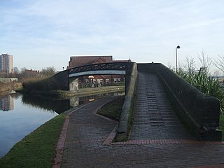
The Manchester Bolton & Bury Canal is a disused canal in Greater Manchester, England, built to link Bolton and Bury with Manchester. The canal, when fully opened, was 15 miles 1 furlong (24 km) long. It was accessed via a junction with the River Irwell in Salford. Seventeen locks were required to climb to the summit as it passed through Pendleton, heading northwest to Prestolee before it split northwest to Bolton and northeast to Bury. Between Bolton and Bury the canal was level and required no locks. Six aqueducts were built to allow the canal to cross the rivers Irwell and Tonge and several minor roads.

<span class="mw-page-title-main">Castlefield</span> Conservation area in Manchester, England

Castlefield is an inner-city conservation area in Manchester, North West England. The conservation area which bears its name is bounded by the River Irwell, Quay Street, Deansgate and Chester Road. It was the site of the Roman era fort of Mamucium or Mancunium which gave its name to Manchester. It was the terminus of the Bridgewater Canal, the world's first industrial canal, built in 1764; the oldest canal warehouse opened in 1779. The world's first passenger railway terminated here in 1830, at Liverpool Road railway station and the first railway warehouse opened here in 1831.

<span class="mw-page-title-main">Bentley Canal</span>

The Bentley Canal is an abandoned canal that was part of the Birmingham Canal Navigations. A very short section still exists where it joins the Wyrley and Essington Canal in Wolverhampton. From there it headed generally southeast through Willenhall and Walsall and connected with the Anson Branch and thus the Walsall Canal. The main line opened in 1843, with the Neachell Hall Branch following two years later. The branch closed in 1953 and the main line in the early 1960s.

<span class="mw-page-title-main">Huddersfield Broad Canal</span> Navigation canal in West Yorkshire, England

The Huddersfield Broad Canal or Sir John Ramsden's Canal, is a wide-locked navigable canal in West Yorkshire in northern England. The waterway is 3.75 miles (6 km) long and has 9 wide locks. It follows the valley of the River Colne and connects the Calder and Hebble Navigation at Cooper Bridge junction with the Huddersfield Narrow Canal near Aspley Basin in Huddersfield.

<span class="mw-page-title-main">Ancoats</span> Area of Manchester, Greater Manchester, England

Ancoats is an area of Manchester, England, next to the Northern Quarter, the northern part of Manchester city centre.

<span class="mw-page-title-main">Islington Branch Canal</span>

The Islington Branch Canal was a short canal branch at Ancoats in north-west England, which joined the main line of the Ashton Canal between locks 1 and 2.

<span class="mw-page-title-main">River Spodden</span> River in North West England

The River Spodden is a watercourse in North West England, one of two major tributaries of the River Roch. It rises in the Lancashire South Pennine hills north of Whitworth and flows south through what is now known as the Whitworth Valley to Rochdale, Greater Manchester, where the river merges with the River Roch. Nestled within the picturesque wooded valley is Healey Dell Nature Reserve.

<span class="mw-page-title-main">Grosvenor Canal</span> Former canal in the Pimlico area of London

Grosvenor Canal was a canal in the Pimlico area of London, opened in 1824. It was progressively shortened, as first the railways to Victoria Station and then the Ebury Bridge housing estate were built over it. It remained in use until 1995, enabling barges to be loaded with refuse for removal from the city, making it the last canal in London to operate commercially. A small part of it remains within the Grosvenor Waterside development.

The BCN Main Line, or Birmingham Canal Navigations Main Line is the evolving route of the Birmingham Canal between Birmingham and Wolverhampton in England.

<span class="mw-page-title-main">Architecture of Manchester</span> Overview of the architecture of Manchester, England

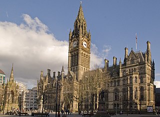
The architecture of Manchester demonstrates a rich variety of architectural styles. The city is a product of the Industrial Revolution and is known as the first modern, industrial city. Manchester is noted for its warehouses, railway viaducts, cotton mills and canals – remnants of its past when the city produced and traded goods. Manchester has minimal Georgian or medieval architecture to speak of and consequently has a vast array of 19th and early 20th-century architecture styles; examples include Palazzo, Neo-Gothic, Venetian Gothic, Edwardian baroque, Art Nouveau, Art Deco and the Neo-Classical.

<span class="mw-page-title-main">Horseley Ironworks</span>

The Horseley Ironworks was a major ironworks in the Tipton area in the county of Staffordshire, now the West Midlands, England.

<span class="mw-page-title-main">Ridgacre Branch</span> UK canal

The Ridgacre Branch is a canal branch of the Wednesbury Old Canal, part of the Birmingham Canal Navigations, in the West Midlands, England. It opened in 1828, to serve collieries and iron works, and was disused by the 1960s. Except for its branches and a small section at the eastern end, which have been filled in, most of it is still in water, but it is not navigable as a low-level bridge carrying the Black Country New Road spans the entrance.

<span class="mw-page-title-main">Wednesbury Oak Loop</span>

The Wednesbury Oak Loop, sometimes known as the Bradley Arm, is a canal in the West Midlands, England. It is part of the Birmingham Canal Navigations (BCN), and was originally part of James Brindley's main line, but became a loop when Thomas Telford's improvements of the 1830s bypassed it by the construction of the Coseley Tunnel. The south-eastern end of the loop was closed and in parts built over, following the designation of the entire loop as "abandoned" in 1954, including the section which was filled in at the beginning of the 1960s to make way for the Glebefields Estate in Tipton.

<span class="mw-page-title-main">Piethorne Brook</span> Stream in Greater Manchester, England

Piethorne Brook is a watercourse in Greater Manchester. It is a tributary of the River Beal.

<span class="mw-page-title-main">Murrays' Mills</span> Mill complex in Manchester, England

Murrays' Mills is a complex of former cotton mills on land between Jersey Street and the Rochdale Canal in the district of Ancoats, Manchester, England. The mills were built for brothers Adam and George Murray.

<span class="mw-page-title-main">Heywood Branch Canal</span> Branch of Rochdale Canal

The Heywood Branch Canal was a branch of the Rochdale Canal from Castleton which led to Heywood. It opened in 1834 and carried traffic until 1937. It was abandoned in 1952, along with most of the Rochdale Canal, and although the Rochdale Canal has been reopened, the junction lies under the embankments of the M62 motorway.

<span class="mw-page-title-main">Bradley Branch</span>

The Bradley Branch or Bradley Locks Branch was a short canal of the Birmingham Canal Navigations in the West Midlands, England. Completed in 1849, it included nine locks, and had a number of basins which enabled it to service local collieries and industrial sites. The locks were unusual, as they had a single gate at both ends, rather than double gates at the bottom end. The route closed in the 1950s, and the top seven locks were covered over and landscaped.

<span class="mw-page-title-main">Cotton End, Northampton</span> District of Northampton, England

Cotton End is a small district of the town of Northampton, England, about half a mile south of the town centre, north of the area known as Far Cotton and west of the road from South Bridge to Ransome Road known as Cotton End. The district population is included in the Delapre and Briar Hill Ward of Northampton Council.

Havelock Mills in central Manchester were built between 1820 and 1840. It was probably the largest surviving silk mill in the north-west region in the 1970s and had a unique combination of silk and cotton mills on one site. It was a landmark on the Rochdale Canal, overlooking Tib Lock, one of the Rochdale Nine.

<span class="mw-page-title-main">Burnley Embankment</span> Waterway in the United Kingdom

The Burnley Embankment is an embankment carrying the Leeds and Liverpool Canal across the Calder and Brun valleys in Burnley, Lancashire. Also known as the Straight Mile, the embankment is 1,256 yards long and the canal runs up to 60 feet (18 m) above the valley floor. The structure was chosen as one of the original Seven Wonders of the Waterways, and has been awarded a Red Wheel by the Transport Trust.

References

  1. Hadfield & Biddle 1970 , p. 264
  2. 1 2 Priestley 1831, p. 542.
  3. 1 2 3 "The rise, fall and rise of the Rochdale". Rochdale Observer. Archived from the original on 5 November 2009.
  4. "No way back for the town basin". Rochdale Observer. Archived from the original on 5 November 2009.
  5. Ordnance Survey, 1:25,000 map
  6. "Walk: Exploring Abandoned Sections of the Rochdale Canal". The Railway and Canal Historical Society. 29 February 2024. Archived from the original on 2 February 2025.
  7. Historic England. "Rochdale Branch Canal Arm Halfpenny Bridge (1031919)". National Heritage List for England .
  8. 1 2 3 4 5 Ordnance Survey, 1:1056 map, 1851
  9. 1 2 3 4 Ordnance Survey, 1:500 map, 1892
  10. 1 2 3 4 5 Ordnance Survey, 1:2500 map, 1910
  11. 1 2 3 4 5 Ordnance Survey, 1:2500 map, 1930
  12. 1 2 3 Ordnance Survey, 1:2500 map, 1958

Commons-logo.svg Media related to Rochdale Branch Canal at Wikimedia Commons

53°36′29″N2°08′54″W / 53.6080°N 2.1482°W / 53.6080; -2.1482